 English
 Spanish
 French
 Chinese
 Russian
 Portuguese
 Latest Activation
Charter activations
Earthquake in Iraq
A 7.3 magnitude earthquake struck the northern border of Iraq at 18:18 UTC on 12 November.
The epicentre of the earthquake was in the Kermanshah Province of neighbouring Iran, but it was in close proximity to the border and impacted the Kurdistan region of Iraq.
It is estimated that nine people have died in Kurdistan, and the town of Darbandikhan was particularly affected. Hundreds more are reported to be injured.
This is a mostly mountainous region, and rescue operations have been disrupted by landslides.
7.3 is on the higher end of the Richter scale, and indicates an earthquake that can cause major damage. According to USGS, the earthquake was shallow at a depth of approximately 25 km.
| Tipo de evento: | Earthquake |
| Local do evento: | Iraq |
| Data da Ativação da Carta: | 2017-11-12 |
| Tempo de Ativação da Carta: | 23:41 |
| Zona de Tempo da Ativação da Carta: | UTC+05:30 |
| Requisitante da Carta: | UNITAR/UNOSAT on behalf of UN OCHA |
| ID da Ativação: | 558 |
| Gerenciamento de projeto: | UNITAR/UNOSAT |
Products

Damage assessment in Darbandikhan city and dam, Sulaymaniyah province
Direitos autorais: Pleiades © CNES (2017) - Distribution: Airbus Defence and Space, all rights reserved
Map produced by UNITAR / UNOSAT
Information about the Product
Adquirida: 15/11/2017
Fonte: Plediades
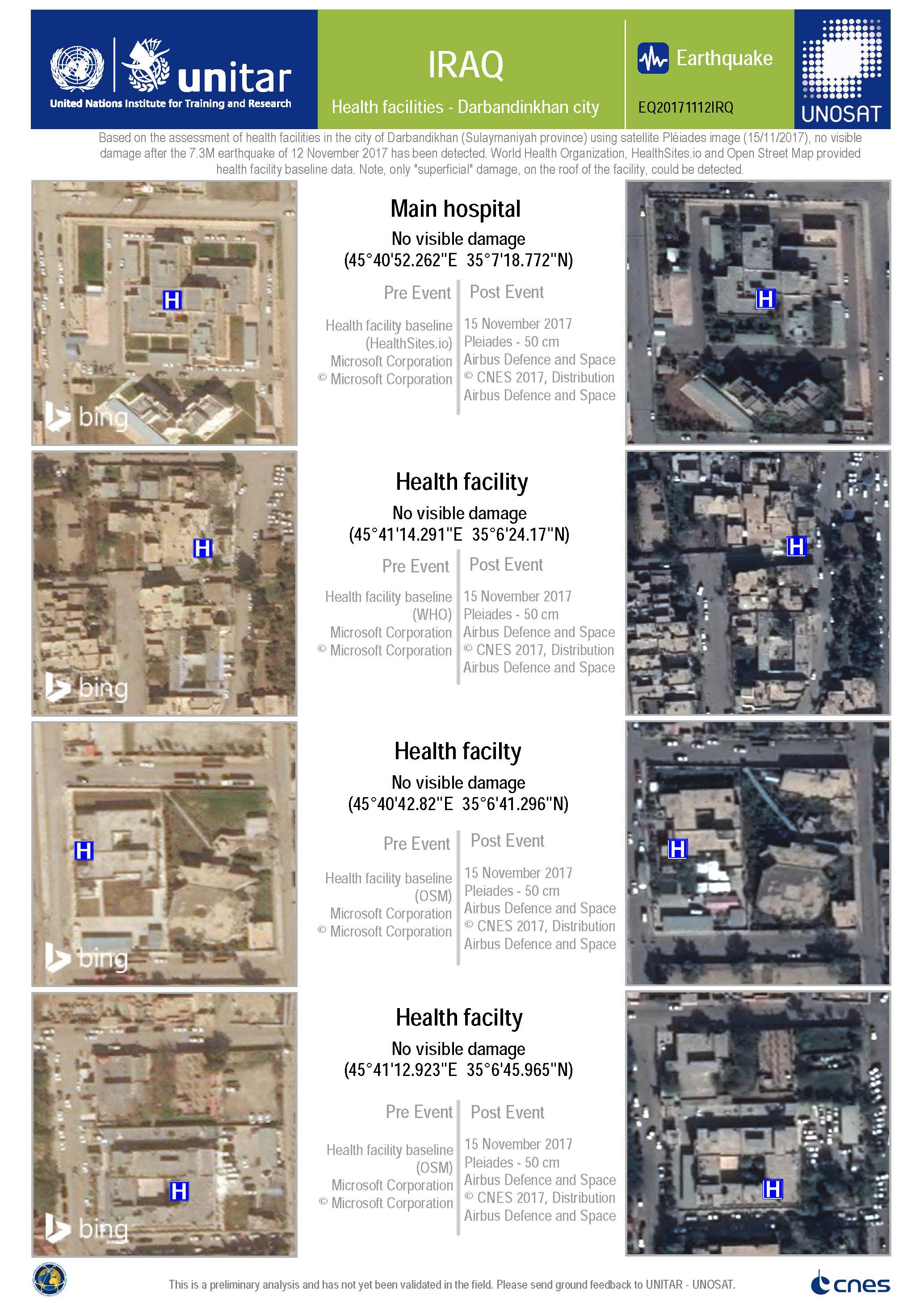
Damage assessment of health facilities in Darbandikhan city
Direitos autorais: Pleiades © CNES (2017) - Distribution: Airbus Defence and Space, all rights reserved
Map produced by UNITAR / UNOSAT
Information about the Product
Adquirida: 15/11/2017
Fonte: Pleiades
 Voltar ao arquivo completo da Ativação

