 English
 Spanish
 French
 Chinese
 Russian
 Portuguese
 最新宪章启动
Charter activations
中美洲飓风、洪水、滑坡;萨尔瓦多火山爆发
斯坦飓风10月1日在尤卡坦半岛登陆,随后几天在中美洲引发重大洪灾和滑坡。有4万多人受灾。据报道有70人死亡。在萨尔瓦多,伊尔阿马特佩克火山(圣安那)于10月1日当地时间8时20分爆发,造成火山西部地区居民至少两人死亡和约1万人受到影响。10月5日宪章启动为终端用户萨尔瓦多国家登记中心提供帮助。应联合国人道主义事务协调厅(UN-OCHA)的请求,这次呼叫延至10月7日。
| 事件类型: | 飓风、火山 |
| 事件地点: | 中美洲:尼加拉瓜、萨尔瓦多、危地马拉、墨西哥 |
| 启动宪章的日期: | 2005年10月5日 |
| 宪章要求者: | 阿根廷SIFEM;UN-OCHA |
| 项目经理: | Instituto Nacional del Agua |
Products

Armenia Salvador SPOT-4
版权: CNES 2004, 2005
Distributed by Spotimage Processing: Instituto Nacional del Agua, Argentina, map created 16/10/2005
Information about the Product
已获得: 11/10/2005, 23/03/2004
Post- and pre-disaster SPOT-4 images showing flooding extent in Armenia, La Libertad, El Salvador.
源: SPOT-4, 10m resolution

Pre and post-disaster SPOT-4 images showing flooding extent in Armenia, La Libertad, El Salvador.
版权: CNES 2004, 2005, distributed by SPOT
Image Processing: Instituto Nacional del Agua, Argentina, map created 16/10/2005
Information about the Product
已获得: 11/10/2005, 23/03/2004
源: SPOT-4, 10m resolution

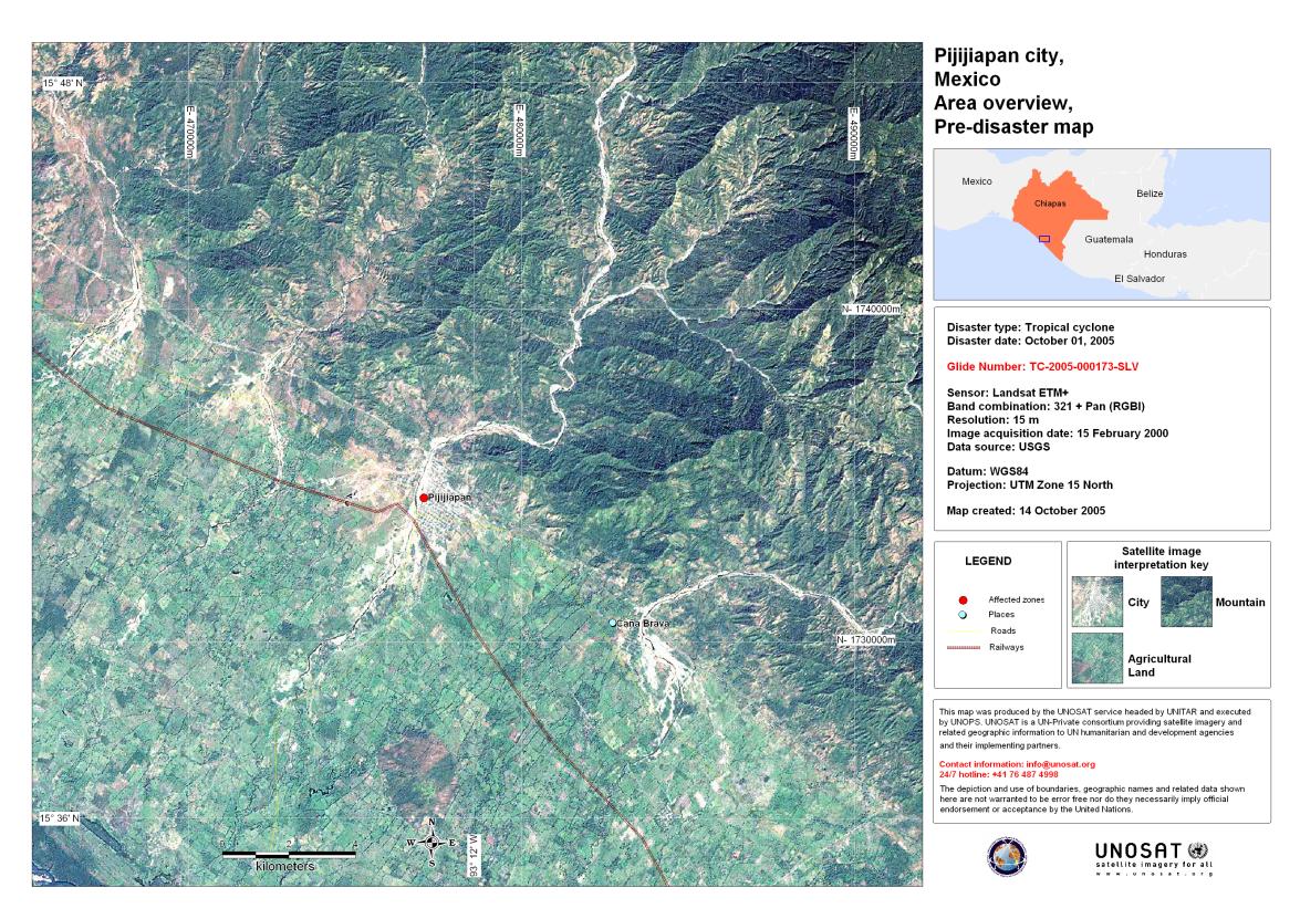
Chiapas State, Mexico, Post-disaster map
版权: Background: Landsat 7 satellite image derived map
showing Chiapas prior to hurricane Stan.
Flood extent extracted from RADARSAT WS data acquired 10/10/2005
Image processing: SERVIR Project / NASA, map created 15/10/2005 by UNOSAT
USGS 2000
Radarsat Intl., 2005
Information about the Product
已获得: Landsat (pre-disaster): 15/02/2000
RADARSAT (post-disaster): 10/10/2005
源: Landsat 7, RADARSAT, 15m resolution

Do Lempa-El Salvador - 11 Oct 05 - SPOT
版权: CNES 2004, 2005
Distributed by Spotimage Processing: Instituto Nacional del Agua, Argentina.
Information about the Product
已获得: 11/10/2005, 23/10/2004
Post- and pre-disaster SPOT-4 and SPOT-5 merged images showing flooding extent in Do Lempa, Salvador.
源: SPOT-4, SPOT-5, 10m resolution


Barra De Santiago Salvador 11 Oct 05 SPOT
版权: CNES 2004, 2005 distributed by Spotimage Processing: Instituto Nacional del Agua, Argentina.
Information about the Product
已获得: 11/10/2005, 23/03/2004
Post- and pre-disaster SPOT-4 and SPOT-5 merged images showing flooding extent in Barra de Santiago Salvador, Salvador.
源: SPOT-4, SPOT-5, 10m resolution


San Jose and Puerto Iztapa
版权: USGS 2000
Image processing, map created 12/10/2005 by Instituto Nacional del Agua, Argentina
Information about the Product
已获得: 15/02/2000
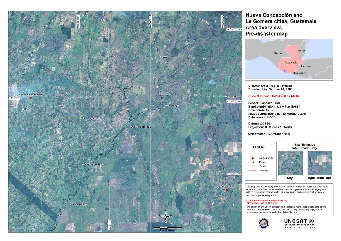
Pre-disaster Landsat 7 satellite image derived map showing San Jose and Puerto Iztapa cities, Guatemala.
源: Landsat 7, ETM+, 15m resolution


Pre-disaster Landsat 7 satellite image derived map showing Santiago Atitlan and Panajachel cities, Guatemala, prior to hurricane Stan on 1st October 2005.
版权: USGS 2000
Image processing, map created 10/10/2005 by Instituto Nacional del Agua, Argentina
Information about the Product
已获得: 15/02/2000
源: Landsat 7, ETM+, 15m resolution

RADARSAT, San Salvador, El Salvador
版权: CSA, distribution RADARSAT 2005 Processing: Instituto Nacional del Agua, Argentina, map created 14/10/2005
Information about the Product
已获得: 26/03/2005, 07/10/2005
Before and After hurricane Stan. RADARSAT data, before hurricane: 26/03/2005 RADARSAT data, after hurricane: 07/10/2005
源: RADARSAT, 15m resolution
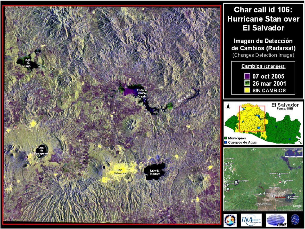
El Salvador RADARSAT Change Detection Change Detection, El Salvador
版权: CSA, distribution RADARSAT 2005 Processing: Instituto Nacional del Agua, Argentina, map created 21/10/2005 Image processing, map created 21/10/2005 by Instituto Nacional del Agua, Argentina
Information about the Product
已获得: 26/03/2005, 07/10/2005
Before and After hurricane Stan. RADARSAT data, before hurricane: 26/03/2005 RADARSAT data, after hurricane: 07/10/2005
源: RADARSAT, 15m resolution

Salvador - Ilogpango - Change Detection Image - RADARSAT Image processing, map created 10/10/2005 by Instituto Nacional del Agua, Argentina Higher resolution version
版权: Canadian Space Agency, CONAE
Map created 10/10/2005 by Instituto Nacional del Agua
Information about the Product
已获得: 26/03/2001, 07/10/2005
源: RADARSAT-1


Acapetahua and Escuintla
版权: USGS 2000
Image processing, map created 14/10/2005 by Instituto Nacional del Agua, Argentina
Information about the Product
已获得: 15/02/2000
Pre-disaster Landsat 7 satellite image derived map showing Acapetahua and Escuintla city, Mexico.
源: Landsat 7, ETM+, 15m resolution
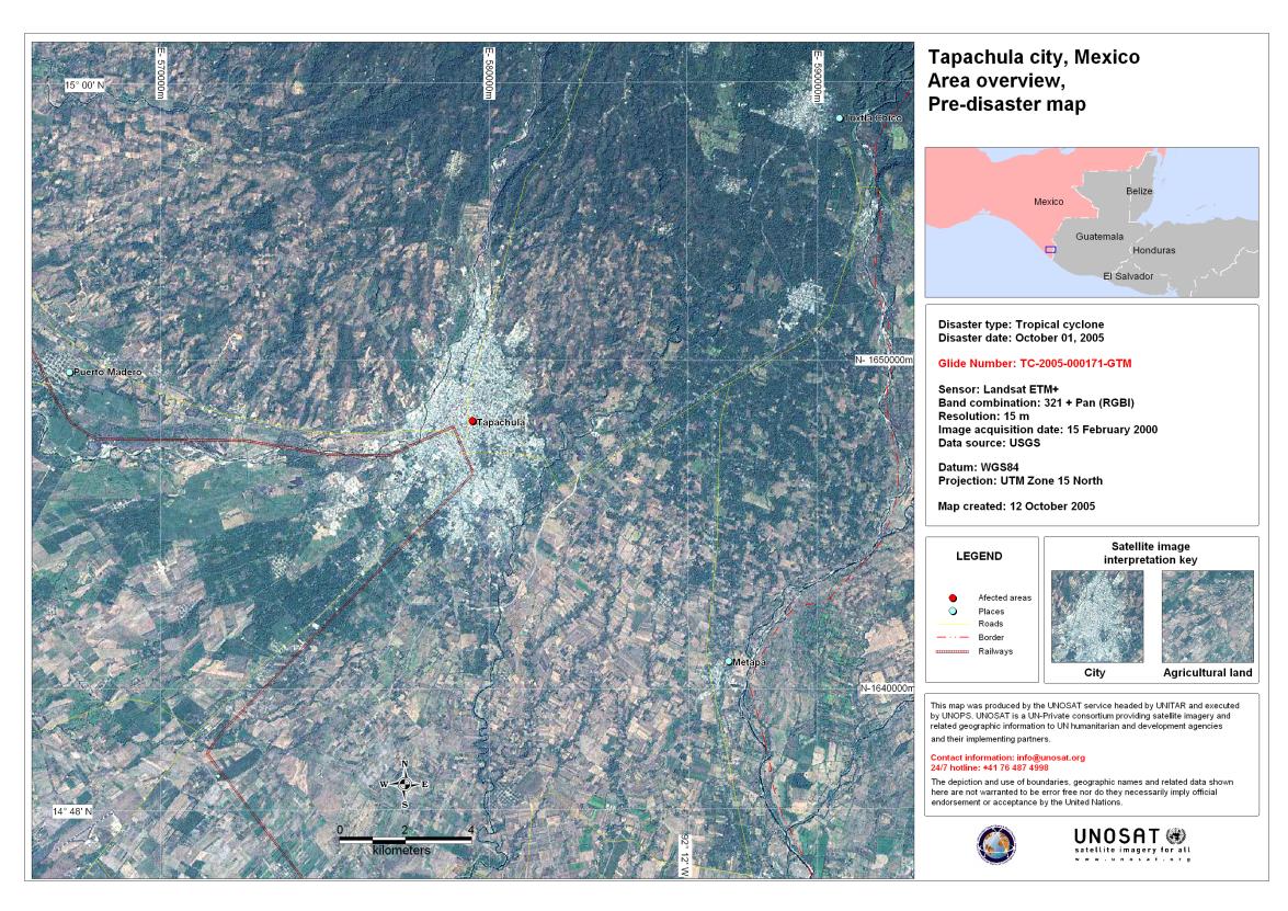
Tapachula Mexico
版权: USGS 2000
Source: Landsat 7, ETM+, 15m resolution Acquired: 15/02/2000 Pre-disaster Landsat 7 satellite image derived map showing Tapachula city, Mexico.
Copyright: USGS 2000 Image processing, map created 14/10/2005 by Instituto Nacional del Agua, Argentina
Information about the Product
已获得: 15/02/2000
Pre-disaster Landsat 7 satellite image derived map showing Tapachula city, Guatemala.
源: Landsat 7, ETM+, 15m resolution


Champerico city, Guatemala, pre-disaster
版权: USGS 2000
Image processing, map created 12/10/2005 by Instituto Nacional del Agua, Argentina
Information about the Product
已获得: 15/02/2000
Pre-disaster Landsat 7 satellite image derived map showing Champerico city, Guatemala.
源: Landsat 7, ETM+, 15m resolution


Champerico Post-disaster Map
版权: USGS 2000
Image processing, map created 12/10/2005 by Instituto Nacional del Agua, Argentina
Information about the Product
已获得: Landat 7: 15/02/2000
RADARSAT-1: 10/10/2005
Pre-disaster Landsat 7 satellite image derived map showing Champerico city, Guatemala.
源: RADARSAT-1; Landsat 7 ETM+, 15m resolution


Chiapa De Corzo Chiapas
版权: CNES 2003, 2005, distributed by Spotimage Processing: Instituto Nacional del Agua, Argentina.
Information about the Product
已获得: 09/10/2005, 26/10/2003
Post- and pre-disaster SPOT-4 images showing flooding extent in Chiapa de Corzo, Chiapas, Mexico.
源: SPOT-4, 10m resolution


Chiapas Post-disaster
版权: USGS, UNOSAT
Information about the Product
已获得: Landsat 7: 15/02/2000
RADARSAT-1: 10/10/2005
Background: Landsat 7 satellite image derived map
showing Chiapas prior to hurricane Stan.
Flood extent extracted from RADARSAT WS data acquired 10/10/2005
Image processing: SERVIR Project / NASA, map created 15/10/2005 by Instituto Nacional del Agua, Argentina
USGS 2000, RADARSAT Intl., 2005
源: Landsat 7, RADARSAT, 15m resolution

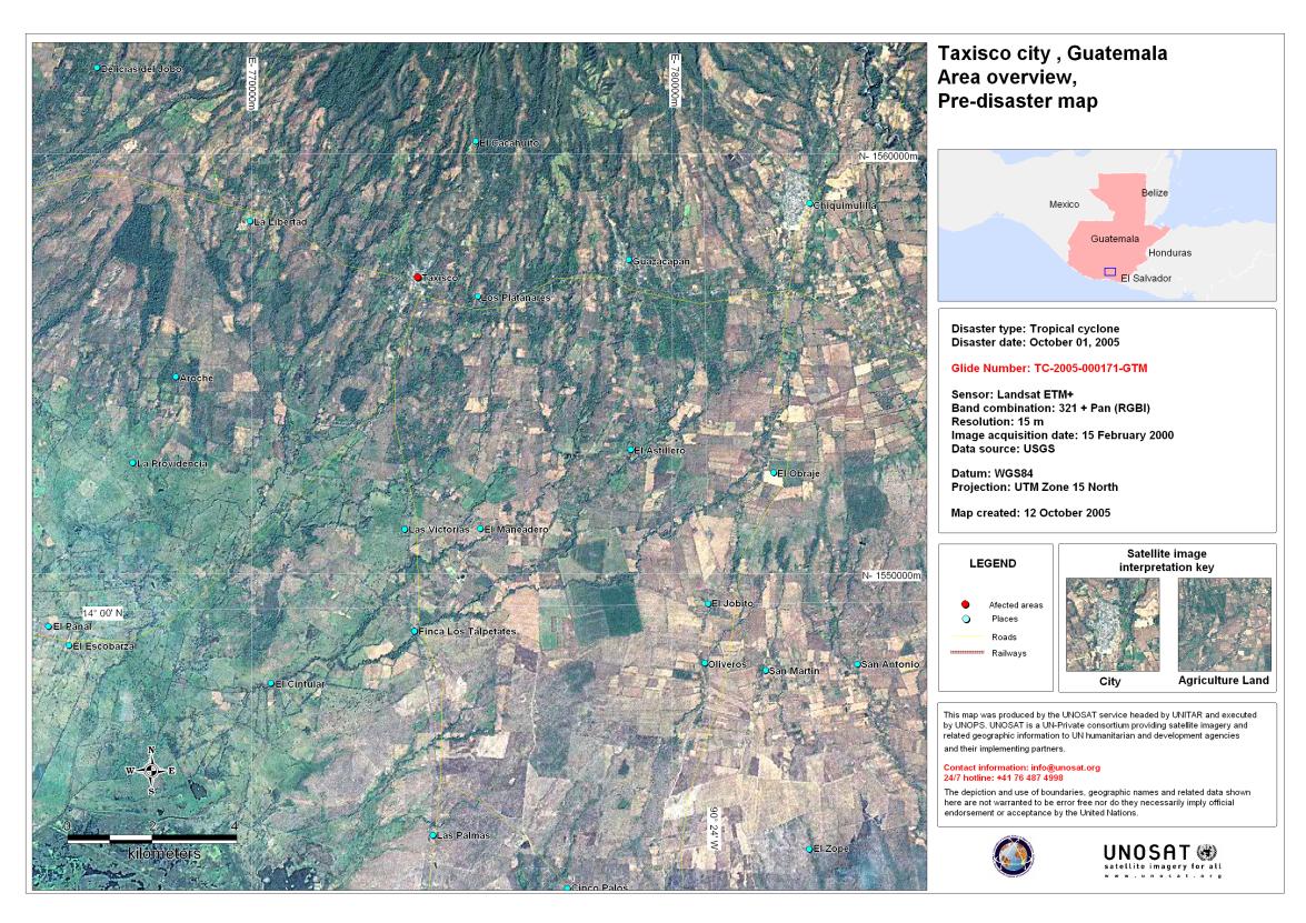
Taxisco city, Guatemala, post-disaster
版权: Flood extent extracted from RADARSAT WS data acquired 10/10/2005
Image processing: SERVIR Project / NASA, map created 15/10/2005 by Instituto Nacional del Agua, Argentina
USGS 2000
RADARSAT Intl., 2005
Information about the Product
已获得: Landsat: 15/02/2000
RADARSAT: 10/10/2005
Background: Landsat 7 satellite image derived map showing Taxisco prior to hurricane Stan.
源: Landsat 7, RADARSAT, 15m resolution


Cuyotenango city, Guatemala - pre-disaster
版权: USGS 2000
UNOSAT
Image processing, map created 13/10/2005 by Instituto Nacional del Agua, Argentina
Information about the Product
已获得: 15/02/2000
Pre-disaster Landsat 7 satellite image derived map showing Cuyutenango city, Guatemala.
源: Landsat 7, ETM+, 15m resolution


Potonico Departemento - Chalatenango, El Salvador. Before and After hurricane Stan.
版权: CSA, distribution RADARSAT 2005 Processing: Instituto Nacional del Agua, Argentina, map created 14/10/2005
Information about the Product
已获得: Pre-disaster: 26/03/2005
Post-disaster: 07/10/2005
源: RADARSAT, 15m resolution


Volcano Santa Ana / Ilamatepec - 07 Oct 05. RADARSAT-1 Image processing, map created 10/10/2005 by Instituto Nacional del Agua, Argentina.
版权: Product prepared by the Canadian Space Agency. RADARSAT is an official trademark of the Canadian Space Agency.
Information about the Product
已获得: 26/03/2001, 07/10/2005
源: RADARSAT-1

Huixtla city, Chiapas Mexico, pre-disaster
版权: USGS 2000
UNOSAT
Image processing, map created 14/10/2005 by Instituto Nacional del Agua, Argentina
Information about the Product
已获得: 15/02/2000
Pre-disaster Landsat 7 satellite image derived map showing Huixtla city, Mexico.
源: Landsat 7, ETM+, 15m resolution
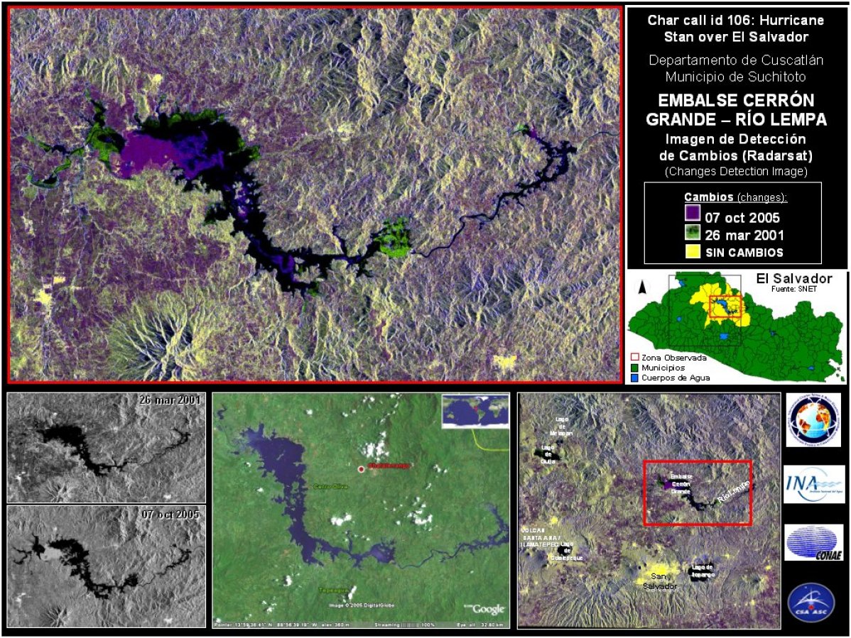
Embalse Cerron Salvador - Change Detection - RADARSAT Image processing, map created 10/10/2005 by Instituto Nacional del Agua, Argentina.
版权: Product prepared by the Canadian Space Agency. RADARSAT is an official trademark of the Canadian Space Agency.
Information about the Product
已获得: 26/03/2001, 07/10/2005
源: RADARSAT-1


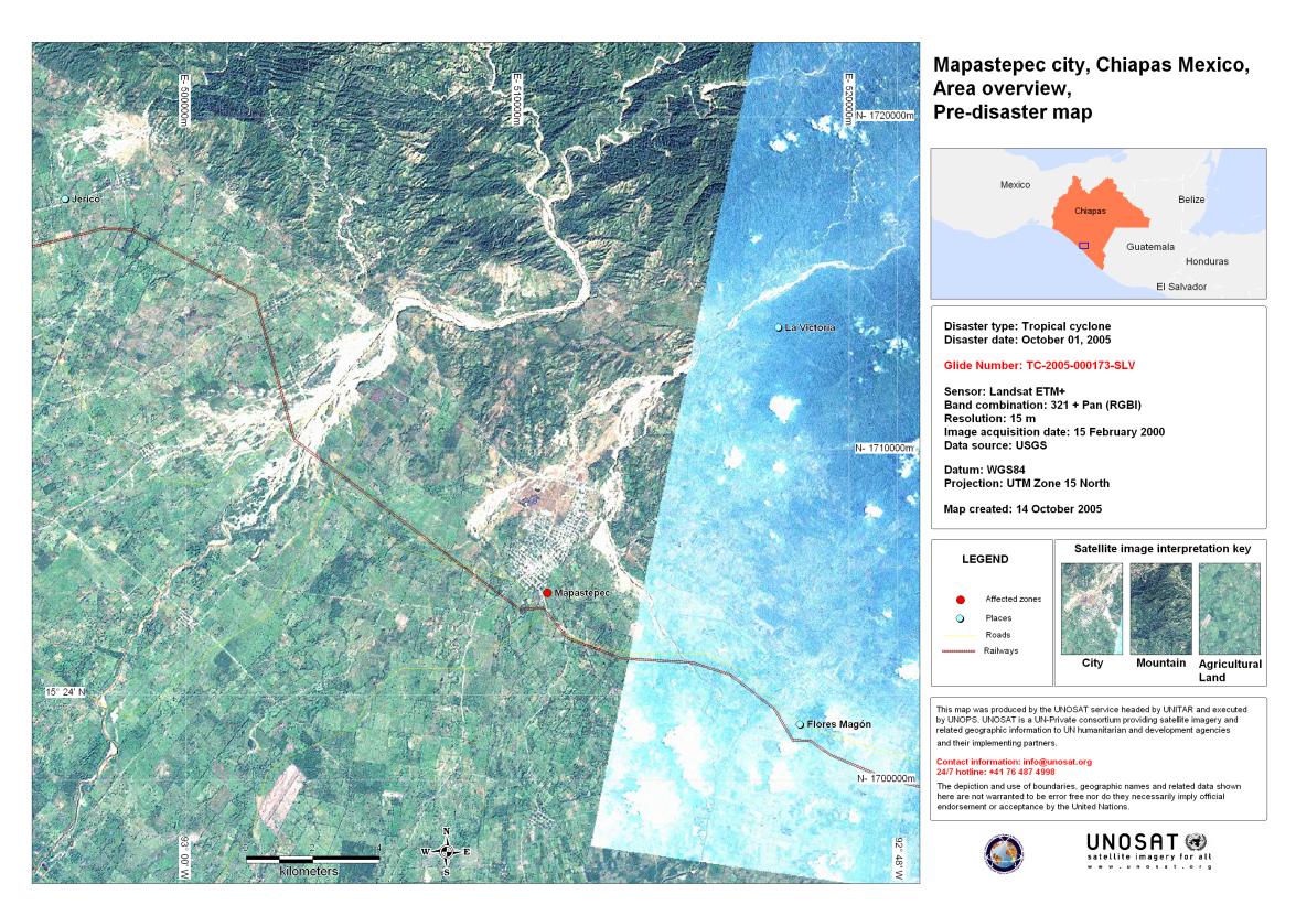
Mapastepec city, Mexico, pre-disaster
版权: USGS 2000 >br>
UNOSAT
Image processing, map created 14/10/2005 by Instituto Nacional del Agua, Argentina
Information about the Product
已获得: 15/02/2000
Pre-disaster Landsat 7 satellite image derived map showing Mapastepec city, Mexico.
源: Landsat 7, ETM+, 15m resolution


Motozintla city, Mexico, pre-disaster
版权: USGS 2000
UNOSAT
Image processing, map created 14/10/2005 by Instituto Nacional del Agua, Argentina
Information about the Product
已获得: 15/02/2000
Pre-disaster Landsat 7 satellite image derived map showing Motozintla city, Mexico.
源: Landsat 7, ETM+, 15m resolution


Lago Guija - Laguna Metapan, Hurricane Stan over El Salvador. Change Detection image - RADARSAT Image processing, map created 10/10/2005 by Instituto Nacional del Agua, Argentina
版权: Canadian Space Agency, CONAE
Map created 10/10/2005 by Instituto Nacional del Agua
Information about the Product
已获得: 26/03/2001, 07/10/2005
源: RADARSAT-1

 返回完整的响应档案

