 English
 Spanish
 French
 Chinese
 Russian
 Portuguese
 Последняя Активация
Charter activations
Hurricane, floods, landslides in Central America; Volcanic eruption in El Salvador
Hurricane Stan which made landfall on the Yucatan peninsula on 1st October caused heavy flooding and landslides over the next days in Central America. More than 40,000 people were affected. 70 people were reported dead. In El Salvador, the Ilamatepec (Santa Ana) volcano erupted on 1st October at around 8:20 local time, causing at least two deaths and affecting some 10,000 people living in areas west of the volcano. The Charter was activated on the 5th of October to assist the end user, Centro Nacional de Registros of El Salvador. The call was extended on 7th October at the request of UN-OCHA.
| Тип события: | Hurricane, Volcano, Floods, Landslides |
| Место события: | Central America: Nicaragua, El Salvador, Guatemala, Mexico |
| Date of Charter Activation: | 05/10/2005 |
| Запрос на активацию поступил от: | SIFEM-Argentina; UN-OCHA |
| Менеждер проекта от: | Instituto Nacional del Agua |
Products


Cyclone Fengal Flood Impact around Ampara District, Sri Lanka
Авторские права: Contains modified Copernicus Sentinel data (2024)
Map produced by Mitigation, Research & Development Division, Disaster Management Centre, Sri Lanka.
Information about the Product
Получено: 08/12/2024
Источник: Sentinel-1
Категория: Delineation Map

Flood situation in Philippines, Camarines Norte, Daet.
Авторские права: USGS/NASA Landsat Program
Contains modified Copernicus Sentinel data (2024)
Map produced by Geo-Information Systems
Information about the Product
Получено: Landsat-9: 18/11/2024, Sentinel-2: 04/12/2024
Источник: Landsat-9, Sentinel-2
Категория: Delineation Map

Marine pollution surveillance report of oil spill in Russia
Авторские права: RADARSAT Constellation Mission Imagery © Government of Canada (2024) - RADARSAT is an official mark of the Canadian Space Agency
Map produced by ISTOP
Information about the Product
Получено: 31/12/2024
Источник: RCM
Категория: Delineation Map

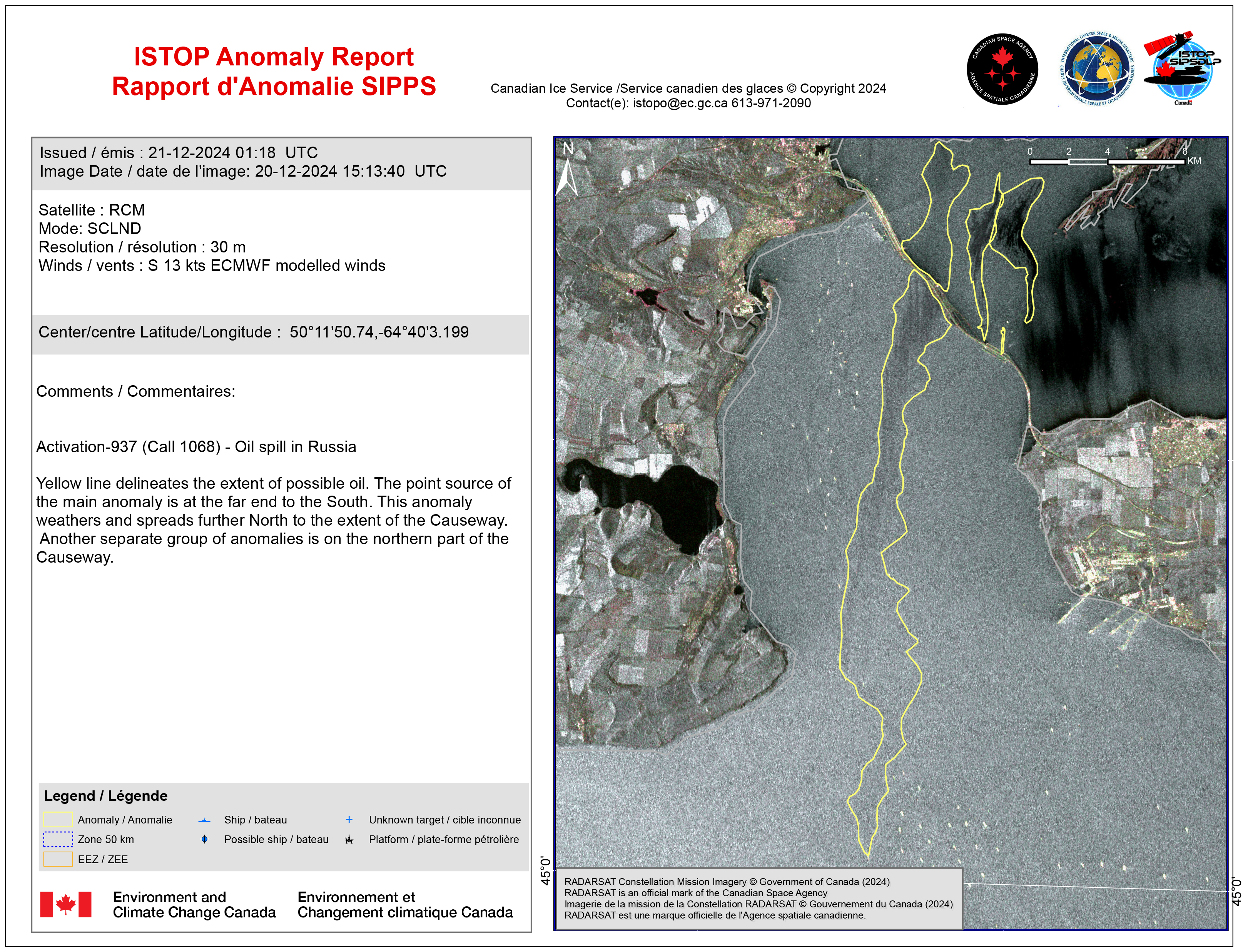
Marine pollution surveillance report of oil spill in Russia
Авторские права: RADARSAT Constellation Mission Imagery © Government of Canada (2024) - RADARSAT is an official mark of the Canadian Space Agency
Map produced by ISTOP
Information about the Product
Получено: 26/12/2024
Источник: RCM
Категория: Delineation Map


Marine pollution surveillance report of oil spill in Russia
Авторские права: RADARSAT Constellation Mission Imagery © Government of Canada (2024) - RADARSAT is an official mark of the Canadian Space Agency
Map produced by ISTOP
Information about the Product
Получено: 21/12/2024
Источник: RCM
Категория: Delineation Map
Marine pollution surveillance report of oil spill in Russia
Авторские права: RADARSAT Constellation Mission Imagery © Government of Canada (2024) - RADARSAT is an official mark of the Canadian Space Agency
Map produced by ISTOP
Information about the Product
Получено: 20/12/2024
Источник: RCM
Категория: Delineation Map


Preliminary satellite-derived damage assessment - Balake, Machinga & Nsanje Districts, Southern Region, Malawi
Download full report
Авторские права: Includes Pleiades material © CNES (2024), Distribution Airbus DS.
Report prepared by UNITAR / UNOSAT
Information about the Product
Получено: 19/12/2024
Источник: Pleiades
Категория: Reference Map


Grading Product with the damage grade assessment over Metuge
Download full image
Авторские права: © Maxar Technologies, Inc. (2024). Copernicus EMS (© 2021 European Union). Map produced by Copernicus EMS
Information about the Product
Получено: 19/12/2024
Источник: GeoEye,
Категория: Grading Map

ISTOP anomaly report - Marine pollution surveillance report of oil spill in Russia
Авторские права: RADARSAT Constellation Mission Imagery © Government of Canada (2024) - RADARSAT is an official mark of the Canadian Space Agency
Map produced by ISTOP
Information about the Product
Получено: 19/12/2024
Источник: RCM
Категория: Delineation Map

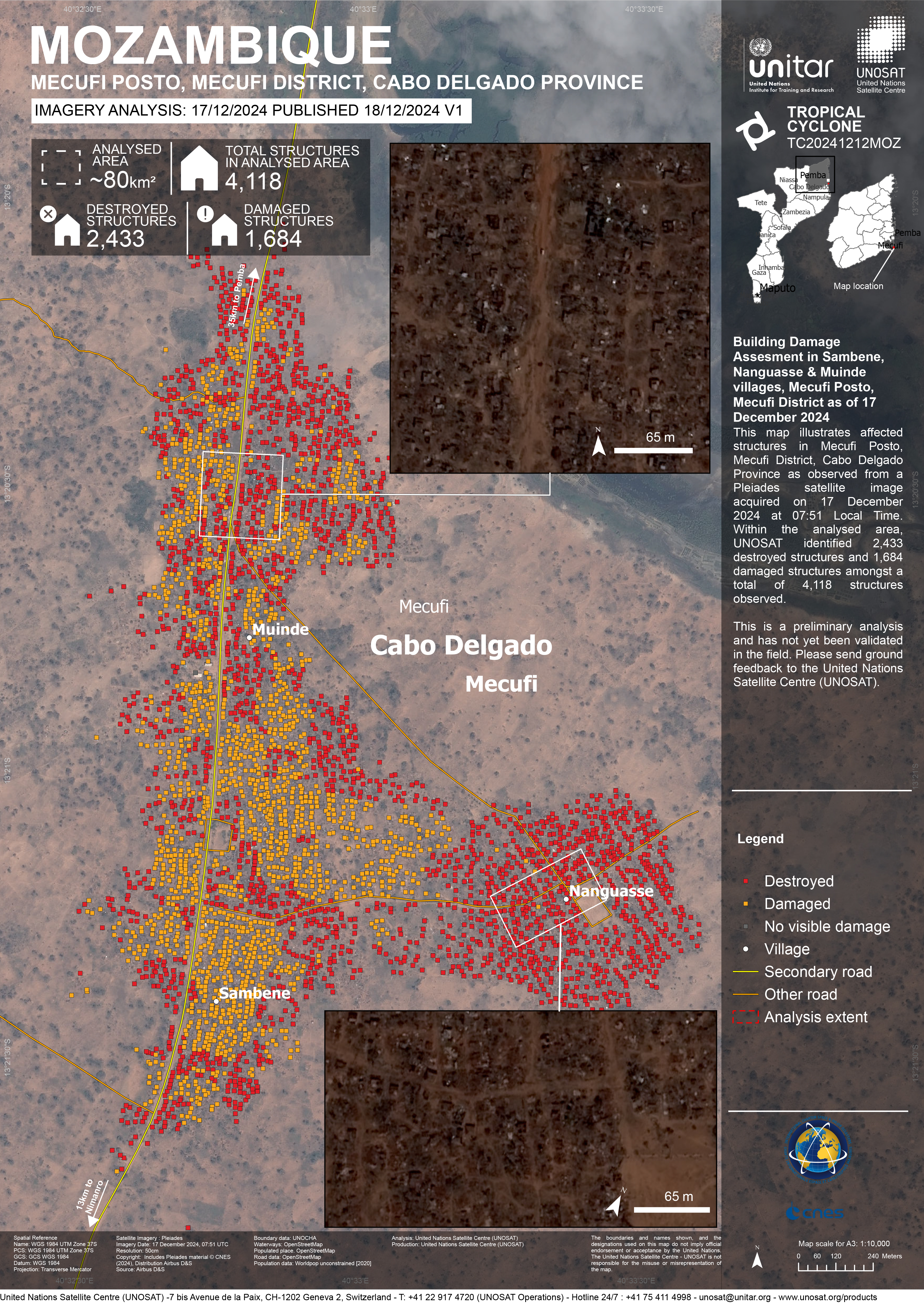
Building Damage Assesment in Sambene, Nanguasse & Muinde villages, Mecufi Posto, Mecufi District
Авторские права: Includes Pleiades material © CNES (2024), Distribution Airbus DS.
Map produced by UNOSAT/ UNITAR
Information about the Product
Получено: 17/12/2024
Источник: Pleiades
Категория: Reference Map

Preliminary satellite-derived damage assessment, Quissanga, Montepuez & Metuge Districts, Cabo Delgado Province, Mozambique
Download full report
Авторские права: Includes Pleiades material © CNES (2024), Distribution Airbus DS.
Map produced by UNOSAT/ UNITAR
Information about the Product
Получено: 17/12/2024
/ 18/12/2024
Источник: Pleiades
Категория: Reference Map

Delineation Product with the identification of the affected areas over Pemba, Mozambique
Download full product
Авторские права: RADARSAT-2 Data and Products © Maxar Technologies Ltd. (2024) – All Rights Reserved
RADARSAT is an official mark of the Canadian Space Agency
Map produced by Copernicus
Information about the Product
Получено: 16/12/2024
Источник: RADARSAT-2
Категория: Delineation Map

Preliminary satellite-derived damage assessment, Mecufi and Cidade de Pemba Districts, Cabo Delgado Province, Mozambique
Download full report
Авторские права: Includes Pleiades material © CNES (2024), Distribution Airbus DS.
Report produced by UNITAR / UNOSAT
Information about the Product
Получено: 16/12/2024
Источник: Pleiades
Категория: Delineation Map

Flood impact and sea surge assessment in the coastal area of Khan Younis and Rafah, Gaza Strip
Авторские права: Maxa2024
Includes Pleiades material © CNES (2024), Distribution Airbus DS.
Map produced by UNITAR / UNOSAT
Information about the Product
Получено: WorldView-2: 01/12/2024
Pleiades: 30/11/2024
Источник: Pleiades
Категория: Grading Map


Flood impact assessment, Sri Lanka
Авторские права: RADARSAT Constellation Mission Imagery © Government of Canada (2024) - RADARSAT is an official mark of the Canadian Space Agency
Map produced by the Canadian Space Agency
Information about the Product
Получено: 28/11/2024
Источник: RCM
Категория: Reference Map

Cyclone "Fengal" Impact in the Mullaitivu District, Sri Lanka.
Авторские права: RADARSAT Constellation Mission Imagery © Government of Canada (2024) - RADARSAT is an official mark of the Canadian Space Agency
Map produced by Mitigation, Research & Development Division, Disaster Management Centre, Sri Lanka.
Information about the Product
Получено: 28/11/2024
Источник: RCM
Категория: Grading Map

Cyclone "Fengal" Impact in the Anuradhapura District, Sri Lanka.
Авторские права: RADARSAT Constellation Mission Imagery © Government of Canada (2024) - RADARSAT is an official mark of the Canadian Space Agency
Map produced by Mitigation, Research & Development Division, Disaster Management Centre, Sri Lanka.
Information about the Product
Получено: 28/11/2024
Источник: RCM
Категория: Delineation Monitoring Maps

Preliminary satellite-derived flood impact assessment in the Batticaloa District, Eastern Province, Sri Lanka
Download full report
Авторские права: Includes Pleiades material © CNES (2024), Distribution Airbus DS.
Report produced by UNITAR / UNOSAT
Information about the Product
Получено: 03/12/2024
Источник: Pleiades
Категория: Dossier

Preliminary satellite-derived flood impact assessment in the Jaffna District, Northern Province, Sri Lanka
Download full report
Авторские права: Includes Pleiades material © CNES (2024), Distribution Airbus DS.
Map produced by UNITAR / UNOSAT
Information about the Product
Получено: 03/12/2024
Источник: Pleiades
Категория: Dossier

Synoptic View of Cyclone "Fengal" Impact in Kilinochchi District, Sri Lanka.
Авторские права: RADARSAT Constellation Mission Imagery © Government of Canada (2024) - RADARSAT is an official mark of the Canadian Space Agency
Map produced by Mitigation, Research & Development Division, Disaster Management Centre, Sri Lanka.
Information about the Product
Получено: 28/11/2024
Источник: RCM
Категория: Grading Map

Synoptic View of Cyclone "Fengal" Impact in the Jaffna District in Sri Lanka.
Авторские права: RADARSAT Constellation Mission Imagery © Government of Canada (2024) - RADARSAT is an official mark of the Canadian Space Agency
Map produced by Mitigation, Research & Development Division, Disaster Management Centre, Sri Lanka.
Information about the Product
Получено: 28/11/2024
Источник: RCM
Категория: Grading Map

Flood impact and sea surge assessment in the coastal area of Deir Al Balah and Khan Younis, Gaza Strip
Авторские права: Includes Pleiades material © CNES (2024), Distribution Airbus DS.
Includes material © AIRBUS DS (2024)
Maxa2024
Map produced by UNITAR / UNOSAT
Information about the Product
Получено: Pleiades: 30/11/2024, WorldView-2: 01/12/2024
Источник: Pleiades, WorldView-2
Категория: Grading Map

Preliminary satellite-derived flood impact assessment in the North Central Province and the Eastern Province, Sri Lanka
Download full report
Авторские права: Contains modified Copernicus Sentinel data (2024)
Report prepared by UNITAR / UNOSAT
Information about the Product
Получено: 02/12/2024
Источник: Sentinel-2
Категория: Dossier


Areas affected by flooding in Santa Cruz, Guanacaste Province, Costa Rica
Авторские права: © (2024) DigitalGlobe, Inc., Longmont CO USA 80503. DigitalGlobe and the DigitalGlobe logos are trademarks of DigitalGlobe, Inc. The use and/or dissemination of this data and/or of any product in any way derived there from are restricted. Unauthorized use and/or dissemination is prohibited
Map produced by the University of Costa Rica
Information about the Product
Получено: 23/11/2024
Источник: WorldView-3
Категория: Delineation Map


Preliminary satellite-derived impact assessment in Aurora Province, Central Luzon Region, The Philippines
Download full report
Авторские права: Includes material © AIRBUS DS (2024)
© NTs OMZ, All Rights Reserved
Report produced by UNITAR / UNOSAT
Information about the Product
Получено: PNEO4: 21/11/2024, Kanopus-V: 23/11/2024, PNEO3: 24/11/2024, Resures-P: 24/11/2024
Источник: PNEO3 / PNEO4 / Kanopus-V / Resures-P
Категория: Dossier


Building Damage Assessment in Panay Island, Catanduanes Province, Bicol Region, The Philippines
Авторские права: Includes Pleiades material © CNES (2024), Distribution Airbus DS.
Map produced by UNITAR / UNOSAT
Information about the Product
Получено: 18/11/2024, 20/11/2024
Источник: Pleiades
Категория: Grading Map

Building Damage Assessment in Bacak Village, Catanduanes Province, Bicol Region, The Philippines
Авторские права: Includes Pleiades material © CNES (2024), Distribution Airbus DS.
Map produced by UNITAR / UNOSAT
Information about the Product
Получено: 18/11/2024, 20/11/2024
Источник: Pleiades
Категория: Grading Map

Building Damage Assessment in Panganiban City, Catanduanes Province, Bicol Region, The Philippines
Авторские права: Includes Pleiades material © CNES (2024), Distribution Airbus DS.
Map produced by UNITAR / UNOSAT
Information about the Product
Получено: 18/11/2024, 20/11/202
Источник: Pleiades
Категория: Grading Map

Building Damage Assessment in Bagamanoc City, Catanduanes Province, Bicol Region, The Philippines
Авторские права: Includes Pleiades material © CNES (2024), Distribution Airbus DS.
Map produced by UNITAR / UNOSAT
Information about the Product
Получено: 18/11/2024, 20/11/2024
Источник: Pleiades
Категория: Grading Map


Areas affected by flood in Lajas Bebedero
Авторские права: Contains modified Copernicus Sentinel data (2024)
© DLR e.V. (2024), Distribution Airbus DS Geo GmbH
Contains modified Copernicus Sentinel data (2024)
Map produced by the University of Costa Rica
Information about the Product
Получено: Sentinel-1: 04/11/2024, 16/11/2024
Tandem-X: 16/11/2024
Источник: Sentinel-1, Tandem-X
Категория: Delineation Map


Preliminary satellite-derived impact assessment, Camarines Sur and Camarines Norte Provinces, Bicol Region, The Philippines
Download full report
Авторские права: Contains modified Copernicus Sentinel data (2024)
Includes Pleiades material © CNES (2024), Distribution Airbus DS.
Report produced by UNITAR / UNOSAT
Information about the Product
Получено: Pleiades: 18/11/2024, Sentinel-2: 19/11/2024
Источник: Sentinel-2, Pleiades
Категория: Dossier

Preliminary satellite-derived impact assessment, Catanduanes Province, Bicol Region, The Philippines
Download full report
Авторские права: Includes Pleiades material © CNES (2024), Distribution Airbus DS.
RADARSAT Constellation Mission Imagery © Government of Canada (2024) - RADARSAT is an official mark of the Canadian Space Agency
Map produced by UNITAR / UNOSAT
Information about the Product
Получено: Pleiades: 18/11/2024
RCM: 18/11/2024
Источник: Pleiades / RCM
Категория: Dossier

Flood situation in Camarines Norte, Daet, Philippines
Авторские права: USGS/NASA Landsat Program
Includes Pleiades material © CNES (2024), Distribution Airbus DS.
Map produced by UE "Geoinformation systems"
Information about the Product
Получено: Landsat 9: 18/11/2024
Pleiades: 18/11/2024
Источник: Landsat 9 / Pleiades
Категория: Reference Map


Areas affected by flooding in Rio Nosara, Costa Rica
Авторские права: RADARSAT Constellation Mission Imagery © Government of Canada (2024) - RADARSAT is an official mark of the Canadian Space
Map produced by the University of Costa Rica
Information about the Product
Получено: 18/11/2024
Источник: RCM
Категория: Reference Map


Armenia Salvador SPOT-4
Авторские права: CNES 2004, 2005
Distributed by Spotimage Processing: Instituto Nacional del Agua, Argentina, map created 16/10/2005
Information about the Product
Получено: 11/10/2005, 23/03/2004
Post- and pre-disaster SPOT-4 images showing flooding extent in Armenia, La Libertad, El Salvador.
Источник: SPOT-4, 10m resolution
Pre-disaster Landsat 7 satellite image derived map showing Nueva Conception and La Gomera cities, Guatemala.
Авторские права: USGS 2000
UNOSAT
Image processing, map created 12/10/2005 by Instituto Nacional del Agua, Argentina
Information about the Product
Получено: 15/02/2000
Источник: Landsat 7, ETM+, 15m resolution

Pre and post-disaster SPOT-4 images showing flooding extent in Armenia, La Libertad, El Salvador.
Авторские права: CNES 2004, 2005, distributed by SPOT
Image Processing: Instituto Nacional del Agua, Argentina, map created 16/10/2005
Information about the Product
Получено: 11/10/2005, 23/03/2004
Источник: SPOT-4, 10m resolution

Chiapas State, Mexico, Post-disaster map
Авторские права: Background: Landsat 7 satellite image derived map
showing Chiapas prior to hurricane Stan.
Flood extent extracted from RADARSAT WS data acquired 10/10/2005
Image processing: SERVIR Project / NASA, map created 15/10/2005 by UNOSAT
USGS 2000
Radarsat Intl., 2005
Information about the Product
Получено: Landsat (pre-disaster): 15/02/2000
RADARSAT (post-disaster): 10/10/2005
Источник: Landsat 7, RADARSAT, 15m resolution

Do Lempa-El Salvador - 11 Oct 05 - SPOT
Авторские права: CNES 2004, 2005
Distributed by Spotimage Processing: Instituto Nacional del Agua, Argentina.
Information about the Product
Получено: 11/10/2005, 23/10/2004
Post- and pre-disaster SPOT-4 and SPOT-5 merged images showing flooding extent in Do Lempa, Salvador.
Источник: SPOT-4, SPOT-5, 10m resolution


Barra De Santiago Salvador 11 Oct 05 SPOT
Авторские права: CNES 2004, 2005 distributed by Spotimage Processing: Instituto Nacional del Agua, Argentina.
Information about the Product
Получено: 11/10/2005, 23/03/2004
Post- and pre-disaster SPOT-4 and SPOT-5 merged images showing flooding extent in Barra de Santiago Salvador, Salvador.
Источник: SPOT-4, SPOT-5, 10m resolution


San Jose and Puerto Iztapa
Авторские права: USGS 2000
Image processing, map created 12/10/2005 by Instituto Nacional del Agua, Argentina
Information about the Product
Получено: 15/02/2000
Pre-disaster Landsat 7 satellite image derived map showing San Jose and Puerto Iztapa cities, Guatemala.
Источник: Landsat 7, ETM+, 15m resolution

Pre-disaster Landsat 7 satellite image derived map showing Nueva Conception and La Gomera cities, Guatemala.
Авторские права: USGS 2000
Image processing, map created 12/10/2005 by Instituto Nacional del Agua, Argentina
Information about the Product
Получено: 15/02/2000
Источник: Landsat 7, ETM+, 15m resolution

Pre-disaster Landsat 7 satellite image derived map showing Santiago Atitlan and Panajachel cities, Guatemala, prior to hurricane Stan on 1st October 2005.
Авторские права: USGS 2000
Image processing, map created 10/10/2005 by Instituto Nacional del Agua, Argentina
Information about the Product
Получено: 15/02/2000
Источник: Landsat 7, ETM+, 15m resolution

RADARSAT, San Salvador, El Salvador
Авторские права: CSA, distribution RADARSAT 2005 Processing: Instituto Nacional del Agua, Argentina, map created 14/10/2005
Information about the Product
Получено: 26/03/2005, 07/10/2005
Before and After hurricane Stan. RADARSAT data, before hurricane: 26/03/2005 RADARSAT data, after hurricane: 07/10/2005
Источник: RADARSAT, 15m resolution
El Salvador RADARSAT Change Detection Change Detection, El Salvador
Авторские права: CSA, distribution RADARSAT 2005 Processing: Instituto Nacional del Agua, Argentina, map created 21/10/2005 Image processing, map created 21/10/2005 by Instituto Nacional del Agua, Argentina
Information about the Product
Получено: 26/03/2005, 07/10/2005
Before and After hurricane Stan. RADARSAT data, before hurricane: 26/03/2005 RADARSAT data, after hurricane: 07/10/2005
Источник: RADARSAT, 15m resolution

Salvador - Ilogpango - Change Detection Image - RADARSAT Image processing, map created 10/10/2005 by Instituto Nacional del Agua, Argentina Higher resolution version
Авторские права: Canadian Space Agency, CONAE
Map created 10/10/2005 by Instituto Nacional del Agua
Information about the Product
Получено: 26/03/2001, 07/10/2005
Источник: RADARSAT-1

Siltepec city, Chiapas Mexico
Авторские права: USGS 2000
Image processing, map created 14/10/2005 by Instituto Nacional del Agua, Argentina
Information about the Product
Получено: 15/02/2000
Pre-disaster Landsat 7 satellite image derived map showing Siltepec city, Mexico.
Источник: Landsat 7, ETM+, 15m resolution


Acapetahua and Escuintla
Авторские права: USGS 2000
Image processing, map created 14/10/2005 by Instituto Nacional del Agua, Argentina
Information about the Product
Получено: 15/02/2000
Pre-disaster Landsat 7 satellite image derived map showing Acapetahua and Escuintla city, Mexico.
Источник: Landsat 7, ETM+, 15m resolution
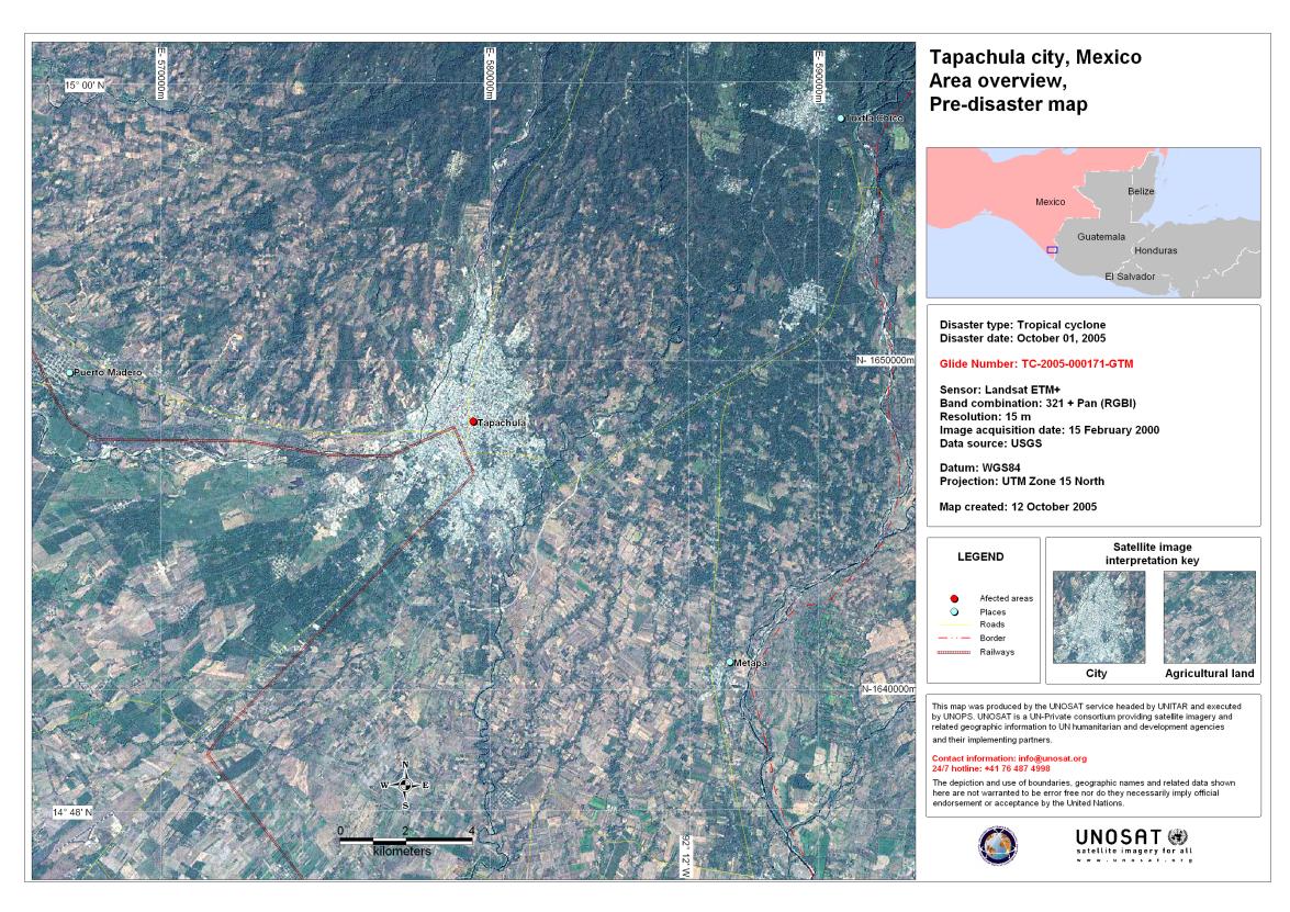
Tapachula Mexico
Авторские права: USGS 2000
Source: Landsat 7, ETM+, 15m resolution Acquired: 15/02/2000 Pre-disaster Landsat 7 satellite image derived map showing Tapachula city, Mexico.
Copyright: USGS 2000 Image processing, map created 14/10/2005 by Instituto Nacional del Agua, Argentina
Information about the Product
Получено: 15/02/2000
Pre-disaster Landsat 7 satellite image derived map showing Tapachula city, Guatemala.
Источник: Landsat 7, ETM+, 15m resolution


Champerico city, Guatemala, pre-disaster
Авторские права: USGS 2000
Image processing, map created 12/10/2005 by Instituto Nacional del Agua, Argentina
Information about the Product
Получено: 15/02/2000
Pre-disaster Landsat 7 satellite image derived map showing Champerico city, Guatemala.
Источник: Landsat 7, ETM+, 15m resolution


Champerico Post-disaster Map
Авторские права: USGS 2000
Image processing, map created 12/10/2005 by Instituto Nacional del Agua, Argentina
Information about the Product
Получено: Landat 7: 15/02/2000
RADARSAT-1: 10/10/2005
Pre-disaster Landsat 7 satellite image derived map showing Champerico city, Guatemala.
Источник: RADARSAT-1; Landsat 7 ETM+, 15m resolution


Pre-disaster Landsat 7 satellite image derived map showing Nueva Conception and La Gomera cities, Guatemala
Авторские права: USGS 2000
Image processing, map created 12/10/2005 by Instituto Nacional del Agua, Argentina
Information about the Product
Получено: 15/02/2000
Источник: Landsat 7, ETM+, 15m resolution
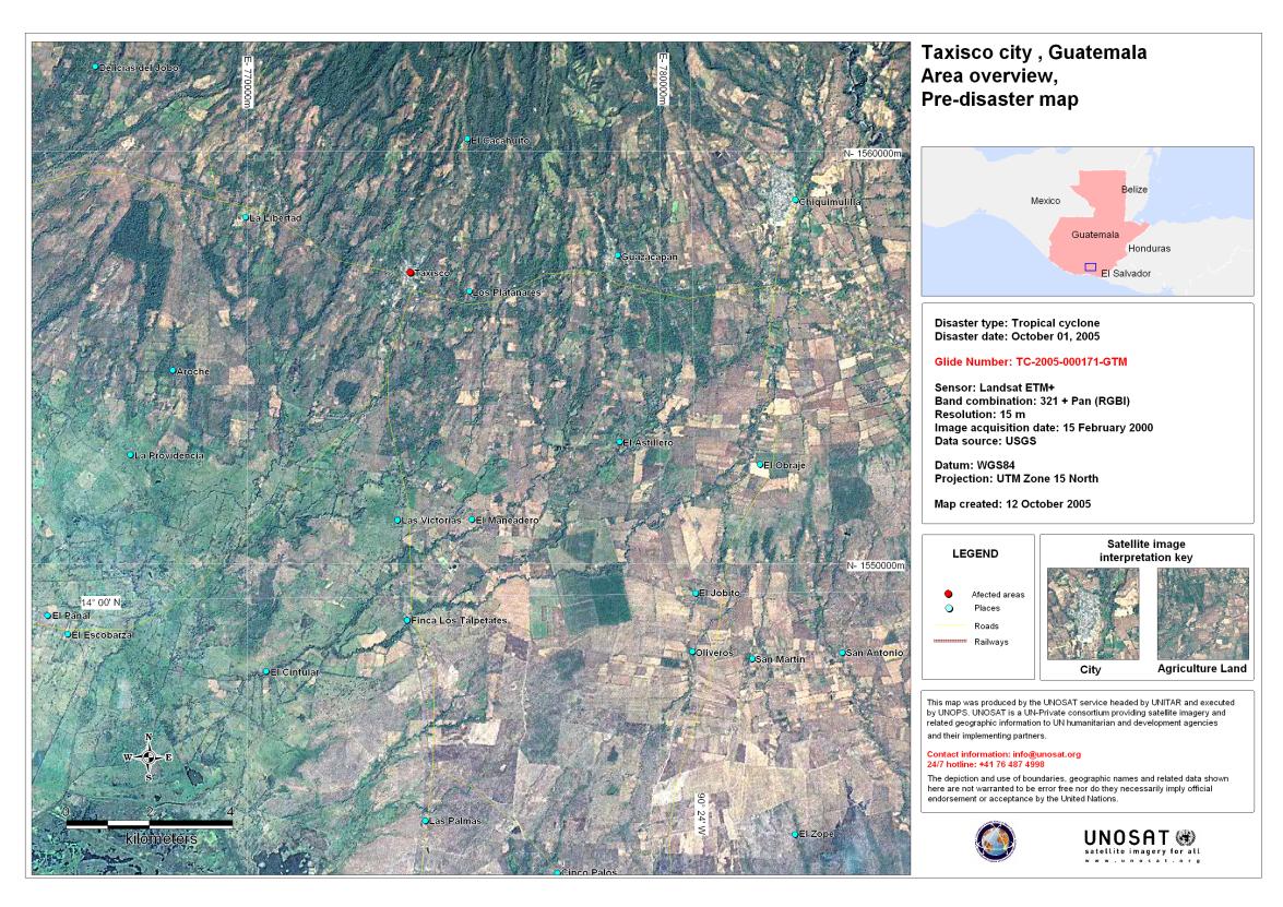
Taxisco city, Guatemala
Авторские права: USGS 2000
Image processing, map created 12/10/2005 by Instituto Nacional del Agua, Argentina
Information about the Product
Получено: 15/02/2000
Pre-disaster Landsat 7 satellite image derived map showing Taxisco city, Guatemala.
Источник: Landsat 7, ETM+, 15m resolution


Chiapa De Corzo Chiapas
Авторские права: CNES 2003, 2005, distributed by Spotimage Processing: Instituto Nacional del Agua, Argentina.
Information about the Product
Получено: 09/10/2005, 26/10/2003
Post- and pre-disaster SPOT-4 images showing flooding extent in Chiapa de Corzo, Chiapas, Mexico.
Источник: SPOT-4, 10m resolution

Pre-disaster Landsat 7 satellite image derived map showing San Jose and Puerto Iztapa cities, Guatemala.
Авторские права: USGS 2000
Image processing, map created 12/10/2005 by Instituto Nacional del Agua, Argentina
Information about the Product
Получено: 15/02/2000
Источник: Landsat 7, ETM+, 15m resolution


Chiapas Post-disaster
Авторские права: USGS, UNOSAT
Information about the Product
Получено: Landsat 7: 15/02/2000
RADARSAT-1: 10/10/2005
Background: Landsat 7 satellite image derived map
showing Chiapas prior to hurricane Stan.
Flood extent extracted from RADARSAT WS data acquired 10/10/2005
Image processing: SERVIR Project / NASA, map created 15/10/2005 by Instituto Nacional del Agua, Argentina
USGS 2000, RADARSAT Intl., 2005
Источник: Landsat 7, RADARSAT, 15m resolution

Taxisco city, Guatemala, post-disaster
Авторские права: Flood extent extracted from RADARSAT WS data acquired 10/10/2005
Image processing: SERVIR Project / NASA, map created 15/10/2005 by Instituto Nacional del Agua, Argentina
USGS 2000
RADARSAT Intl., 2005
Information about the Product
Получено: Landsat: 15/02/2000
RADARSAT: 10/10/2005
Background: Landsat 7 satellite image derived map showing Taxisco prior to hurricane Stan.
Источник: Landsat 7, RADARSAT, 15m resolution


Chiapas Pre-disaster
Авторские права: USGS, UNOSAT
Information about the Product
Получено: 15/02/2000
Pre-disaster Landsat 7 satellite image derived map showing Chiapas state, Mexico.
USGS 2000
Image processing, map created 15/10/2005 by Instituto Nacional del Agua, Argentina
Источник: Landsat 7, 15m resolution

Cuyotenango city, Guatemala - pre-disaster
Авторские права: USGS 2000
UNOSAT
Image processing, map created 13/10/2005 by Instituto Nacional del Agua, Argentina
Information about the Product
Получено: 15/02/2000
Pre-disaster Landsat 7 satellite image derived map showing Cuyutenango city, Guatemala.
Источник: Landsat 7, ETM+, 15m resolution

Tejutla city, Guatemala
Авторские права: USGS 2000
Image processing, map created 13/10/2005 by Instituto Nacional del Agua, Argentina
Information about the Product
Получено: 15/02/2000
Pre-disaster Landsat 7 satellite image derived map showing Tejutla city, Guatemala.
Источник: Landsat 7, ETM+, 15m resolution


Potonico Departemento - Chalatenango, El Salvador. Before and After hurricane Stan.
Авторские права: CSA, distribution RADARSAT 2005 Processing: Instituto Nacional del Agua, Argentina, map created 14/10/2005
Information about the Product
Получено: Pre-disaster: 26/03/2005
Post-disaster: 07/10/2005
Источник: RADARSAT, 15m resolution


Volcano Santa Ana / Ilamatepec - 07 Oct 05. RADARSAT-1 Image processing, map created 10/10/2005 by Instituto Nacional del Agua, Argentina.
Авторские права: Product prepared by the Canadian Space Agency. RADARSAT is an official trademark of the Canadian Space Agency.
Information about the Product
Получено: 26/03/2001, 07/10/2005
Источник: RADARSAT-1

Huixtla city, Chiapas Mexico, pre-disaster
Авторские права: USGS 2000
UNOSAT
Image processing, map created 14/10/2005 by Instituto Nacional del Agua, Argentina
Information about the Product
Получено: 15/02/2000
Pre-disaster Landsat 7 satellite image derived map showing Huixtla city, Mexico.
Источник: Landsat 7, ETM+, 15m resolution
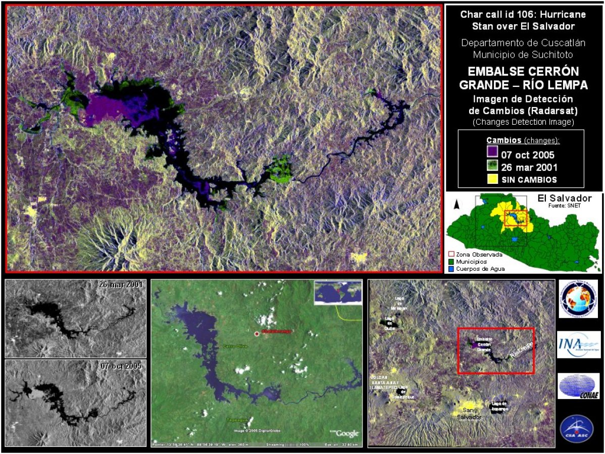
Embalse Cerron Salvador - Change Detection - RADARSAT Image processing, map created 10/10/2005 by Instituto Nacional del Agua, Argentina.
Авторские права: Product prepared by the Canadian Space Agency. RADARSAT is an official trademark of the Canadian Space Agency.
Information about the Product
Получено: 26/03/2001, 07/10/2005
Источник: RADARSAT-1


Mapastepec city, Mexico, pre-disaster
Авторские права: USGS 2000 >br>
UNOSAT
Image processing, map created 14/10/2005 by Instituto Nacional del Agua, Argentina
Information about the Product
Получено: 15/02/2000
Pre-disaster Landsat 7 satellite image derived map showing Mapastepec city, Mexico.
Источник: Landsat 7, ETM+, 15m resolution


San Salvador, El Salvador, before and after hurricane Stan.
Авторские права: CSA, distribution RADARSAT 2005 Processing: Instituto Nacional del Agua, Argentina, map created 14/10/2005
Information about the Product
Получено: Pre-disaster: 26/03/2005
Post-disaster: 07/10/2005
Источник: RADARSAT, 15m resolution

Acapetahua and Escuintla
Авторские права: USGS 2000
Image processing, map created 14/10/2005 by UNOSAT Higher resolution version
Information about the Product
Получено: 15/02/2000
Pre-disaster Landsat 7 satellite image derived map showing Acapetahua and Escuintla city, Mexico.
Источник: Landsat 7, ETM+, 15m resolution

Motozintla city, Mexico, pre-disaster
Авторские права: USGS 2000
UNOSAT
Image processing, map created 14/10/2005 by Instituto Nacional del Agua, Argentina
Information about the Product
Получено: 15/02/2000
Pre-disaster Landsat 7 satellite image derived map showing Motozintla city, Mexico.
Источник: Landsat 7, ETM+, 15m resolution


Lago Guija - Laguna Metapan, Hurricane Stan over El Salvador. Change Detection image - RADARSAT Image processing, map created 10/10/2005 by Instituto Nacional del Agua, Argentina
Авторские права: Canadian Space Agency, CONAE
Map created 10/10/2005 by Instituto Nacional del Agua
Information about the Product
Получено: 26/03/2001, 07/10/2005
Источник: RADARSAT-1

Pre-disaster Landsat 7 satellite image derived map showing Nueva Conception and La Gomera cities, Guatemala.
Авторские права: USGS 2000
UNOSAT
Image processing, map created 12/10/2005 by Instituto Nacional del Agua, Argentina
Information about the Product
Получено: 15/02/2000
Источник: Landsat 7, ETM+, 15m resolution
 Вернуться к полному архиву активаций

