 English
 Spanish
 French
 Chinese
 Russian
 Portuguese
 Последняя Активация
Charter activations
Flooding in Germany
The Elbe region in Saxony was affected by heavy flooding following strong rainfall in conjunction with snowmelt in the Krkonose Mountains (Czech Republic). The Elbe river rose to a level of 7.45 meters. In the city of Dresden, areas near the river had to be evacuated. Along the Elbe, whole districts of several towns were flooded. A state of emergency was declared in four Saxony counties.
| Тип события: | Flooding |
| Место события: | Elbe region of Germany |
| Date of Charter Activation: | 01/04/2006 |
| Запрос на активацию поступил от: | German Joint Information and Situation Centre; European Commission, Civil Protection Unit. |
| Менеждер проекта от: | DLR |
Products

Germany, Elbe Flood: Dresden
Авторские права: Canadian Space Agency 2006 Image processing, map created 08/04/2006 by DLR in the framework of GMES RISKEOS.
Information about the Product
Получено: 06/04/2006 Topographic map with flood mask derived from radar satellite data from April 2006 - Dresden (1:50.000)
Источник: RADARSAT-1
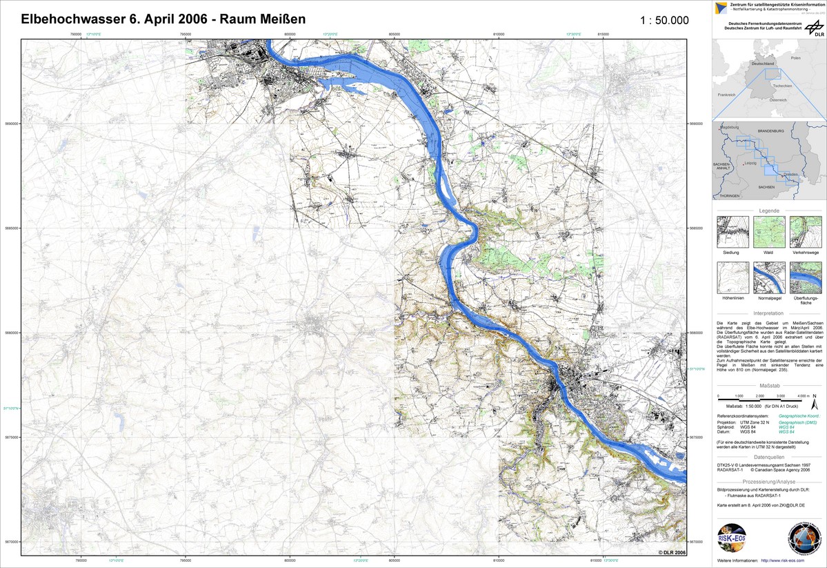
Germany, Elbe Flood: Meissen
Авторские права: Canadian Space Agency 2006 Image processing, map created 08/04/2006 by DLR in the framework of GMES RISKEOS.
Information about the Product
Получено: 06/04/2006 Topographic map with flood mask derived from radar satellite data from April 2006 - Meissen (1:50.000)
Источник: RADARSAT-1
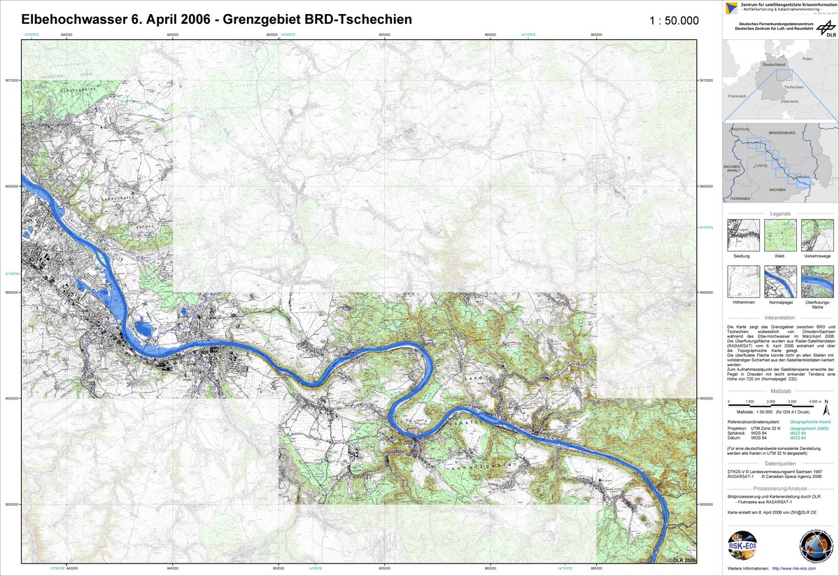
Germany, Elbe Flood: Border Area
Авторские права: Canadian Space Agency 2006 Image processing, map created 08/04/2006 by DLR in the framework of GMES RISKEOS.
Information about the Product
Получено: 06/04/2006 Topographic map with flood mask derived from radar satellite data from April 2006 - German-Czech border area (1:50.000)
Источник: RADARSAT-1

Germany, Elbe Flood: Riesa
Авторские права: ESA 2006 Image processing, map created 08/04/2006 by DLR in the framework of GMES RISKEOS.
Information about the Product
Получено: 04/04/2006 Topographic map with flood mask derived from radar satellite data from April 2006 - Riesa (1:50.000)
Источник: ERS

Germany, Elbe Flood: Torgau
Авторские права: ESA 2006 Image processing, map created 08/04/2006 by DLR in the framework of GMES RISKEOS.
Information about the Product
Получено: 04/04/2006 Topographic map with flood mask derived from radar satellite data from April 2006 - Torgau (1:50.000)
Источник: ERS

Germany, Elbe Flood: Dresden
Авторские права: NRSA 2006, USGS 2000 Image processing, map created 08/04/2006 by DLR in the framework of GMES RISKEOS.
Information about the Product
Получено: 02/04/2006, 24/09/2000 Topographic map with flood mask derived from radar satellite data from April 2006 - Greater Dresden (1:50.000)
Источник: IRS-P6/LISS III, Landsat 7 ETM
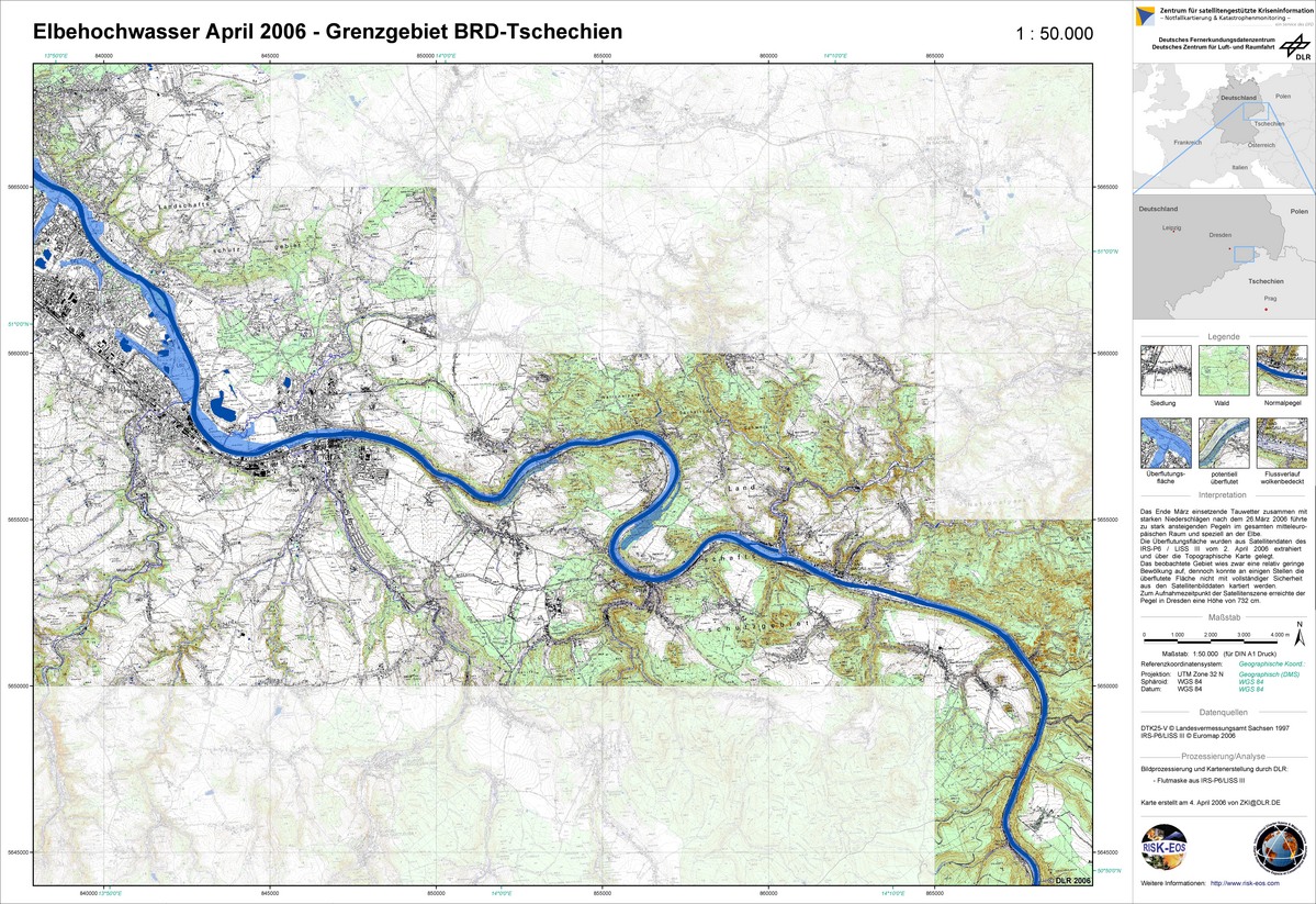
Germany, Elbe Flood: German-Czech Border Area Topographic Map
Авторские права: NRSA 2006 Image processing, map created 04/04/2006 by DLR in the framework of GMES RISKEOS.
Information about the Product
Получено: 02/04/2006 Topographic map with flood mask derived from radar satellite data from April 2006 - German-Czech border area (1:50.000)
Источник: IRS-P6/LISS III

Germany, Elbe Flood: Topographic Map
Авторские права: NRSA 2006 Image processing, map created 04/04/2006 by DLR in the framework of GMES RISKEOS.
Information about the Product
Получено: 02/04/2006 Topographic map with flood mask derived from radar satellite data from April 2006 - Greater Dresden (1:50.000)
Источник: IRS-P6/LISS III
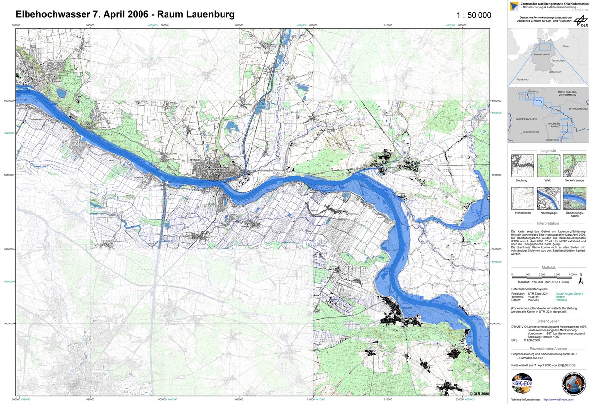
Germany, Elbe Flood: Lauenburg
Авторские права: ESA 2006 Image processing, map created 10/04/2006 by DLR in the framework of GMES RISKEOS.
Information about the Product
Получено: 07/04/2006 Topographic map with flood mask derived from radar satellite data from April 2006 - Lauenburg (1:50.000)
Источник: ERS

Germany, Elbe Flood: Hitzacker
Авторские права: ESA 2006 Image processing, map created 10/04/2006 by DLR in the framework of GMES RISKEOS.
Information about the Product
Получено: 07/04/2006 Topographic map with flood mask derived from radar satellite data from April 2006 - Hitzacker (1:50.000)
Источник: ERS

Germany, Elbe Flood: Dessau
Авторские права: ESA 2006 Image processing, map created 08/04/2006 by DLR in the framework of GMES RISKEOS.
Information about the Product
Получено: 04/04/2006 Topographic map with flood mask derived from radar satellite data from April 2006 - Dessau (1:50.000)
Источник: ERS
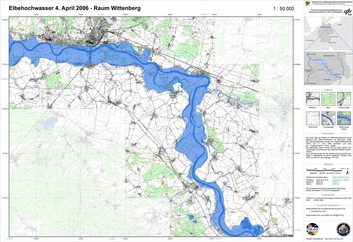
Germany, Elbe Flood: Wittenberg
Авторские права: ESA 2006 Image processing, map created 08/04/2006 by DLR in the framework of GMES RISKEOS.
Information about the Product
Получено: 04/04/2006 Topographic map with flood mask derived from radar satellite data from April 2006 - Wittenberg (1:50.000)
Источник: ERS
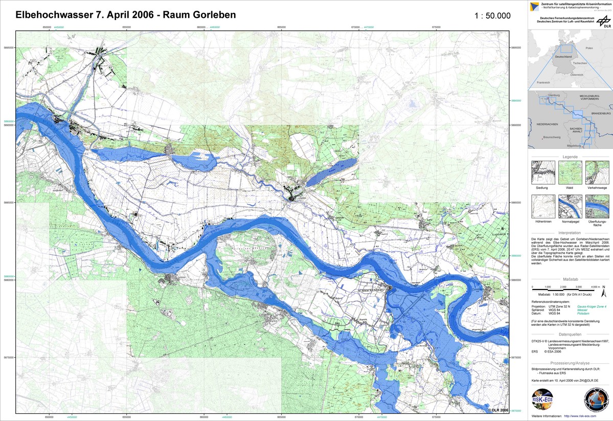
Germany, Elbe Flood: Gorleben
Авторские права: ESA 2006 Image processing, map created 10/04/2006 by DLR in the framework of GMES RISKEOS.
Information about the Product
Получено: 07/04/2006 Topographic map with flood mask derived from radar satellite data from April 2006 - Gorleben (1:50.000)
Источник: ERS
 Вернуться к полному архиву активаций

