 English
 Spanish
 French
 Chinese
 Russian
 Portuguese
 Latest Activation
Charter activations
Flooding in Central Europe
PRAGUE, 31 March, 2006 (AFP) - Large swathes of the Czech Republic, Slovakia, Romania and the German region of Saxony remained on flood alert Friday as the death toll from swollen rivers rose and more people were evacuated from their homes.
In Romania, a child was carried away by a raging river in the region of Suceava, in the north of the country, and his grandfather almost perished in the torrent trying to save him, local authorities said on Friday.
A 13 year old junior canoeing champion was still missing, two days after his boat capsized during a violent storm, police in the western town of Deva said.
At least four people, including two children, have already perished in the floods and two were misssing in the Czech Republic and Slovakia.
The River Elbe on both sides of the Czech-German border continued to be the main focus for concern as the river rose to critical levels late on Friday.
Local authorities in Dresden, Germany, warned they might be forced to evacuate 1,000 people from their homes in Saxony's main city on Saturday after the river rose above the seven-meter (23-foot) mark, more than three times its normal level.
Upstream, at Bad-Schandau, around 150 people were forced to leave their homes on Friday.
In the Czech Republic, a further 120 people were evacuated in the city of Usti Nad Labem, in addition to about 300 people who were cleared from their homes near the river embankment on Thursday and 150 who had to leave their homes around 20 kilometres upstream near Litomerice.
The situation was stable in the two worst-hit Czech regions -- south Moravia and south Bohemia. Around 2,000 people already had been evacuated from the south Moravian town of Znojmo and its surroundings on Wednesday and Thursday.
But the Czech hydrometeorological office late on Friday extended its nationwide flood warning to Monday evening as rain began to fall across the country. More showers and storms are predicted for the weekend together with a warmer spell which could thaw the remaining snow and further swell rivers.
In Slovakia firemen warned that levels of the Morava and Danube rivers will have to be monitored closely. The Slovak interior ministry said Friday that 140 towns and villages, in addition to 1,300 hectares, have been affected thus far, and that river levels were still rising in the east. Around 400 people -- 350 in Brodske, on the banks of the Morava -- have been evacuated thus far.
Czech Prime Minister Jiri Paroubek cut short a visit to Egypt and sought to reassure his countrymen, scarred by the catastrophic floods of 2002 and 1997. "At the moment there is no call for serious concern," he said after a special Cabinet meeting Thursday night. In Prague, a level-two flood alert remained in place Friday in spite of a slow rise in the level of the Vltava which had already overflowed some embankments. Level-three is the highest level alert.
The Romanian Ministry of Environment announced a flood alert in 19 of the country's 41 administrative regions with heavy rainfall predicted over the next days. Dozens of hectares of agricultural land are already under water with strong winds damaging roofs and power lines across the country.
| Type of Event: | Flooding |
| Location of Event: | Central Europe |
| Date of Charter Activation: | 01/04/2006 |
| Charter Requestor: | German Joint Information and Situation Centre; European Commission, Civil Protection Unit; Swiss National Emergency Operations Centre |
| Project Management: | DLR |
Products

Czech Republic Brno Dyje SPOT-5 Flood Impact Map Scale 1:100,000. Flood impact map over the Dyje River (South of Brno), at 1/100,000, with the flood mapping and interpretation draped over SPOT-5 natural colours data (2.5 m) of the 8th April 2006.
Copyright: CNES 2006
Image processing, map created 11/04/2006 by SERTIT in the framework of GMES RISKEOS.
Information about the Product
Acquired: 08/04/2006
Source: SPOT-5

Czech Republic Brno Jihlava Svratka SPOT-5 Flood Impact Map Scale 1:100,000. Flood impact map over the Jihlava and Svratka Rivers (South of Brno), at 1/100,000, with the flood mapping and interpretation draped over SPOT-5 natural colours data (2.5 m) of the 8th April 2006.
Copyright: CNES 2006
Image processing, map created 11/04/2006 by SERTIT in the framework of GMES RISKEOS.
Information about the Product
Acquired: 08/04/2006
Source: SPOT-5

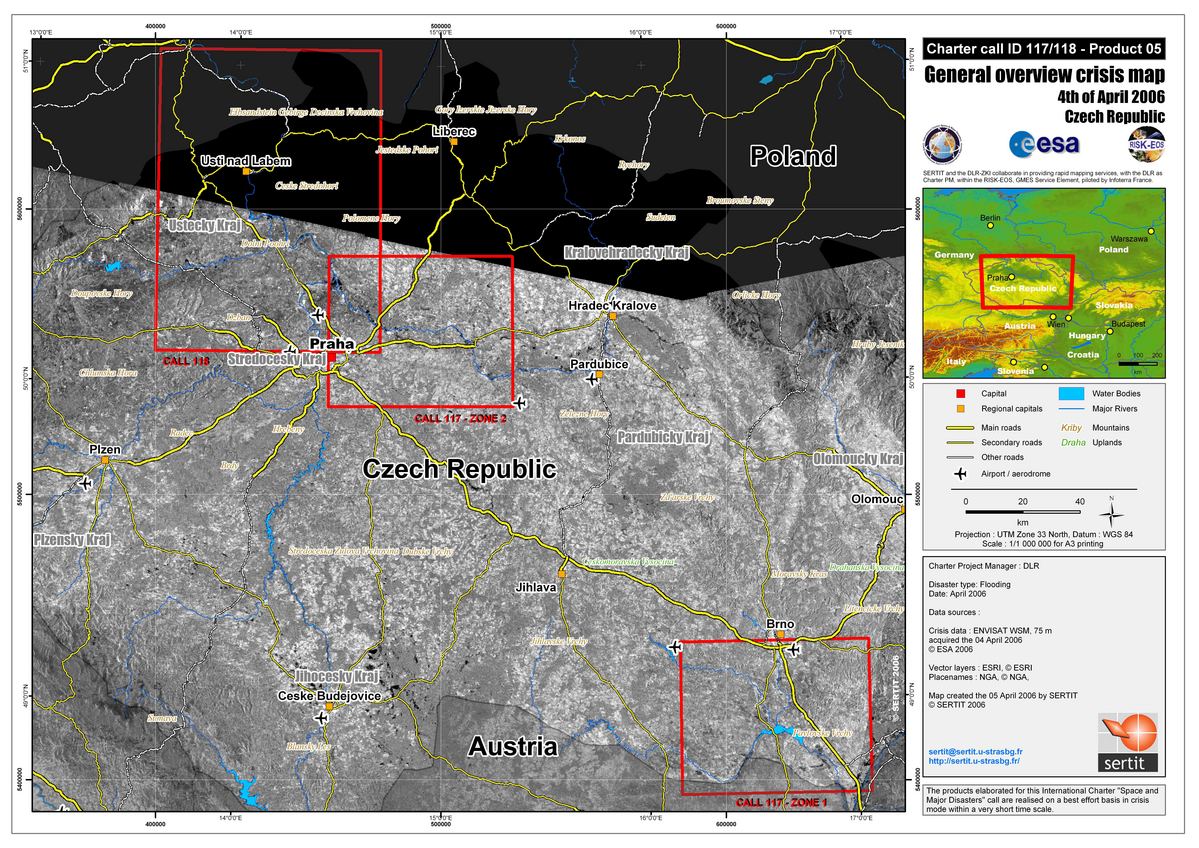
Czech Republic General Reference Spacemap, Scale 1:1000,000
Copyright: USGS 1999-2001, Maryland GLCF. Image processing, map created 05/04/2006 by SERTIT in the framework of GMES RISKEOS.
Information about the Product
Acquired: 24/05/2001 General overview space map covering the flooded areas of the Czech Republic at 1:1,000,000 using Landsat 7 ETM+ data from Maryland GLCF.
Source: Landsat 7 ETM+

Czech Republic Brno Area SPOT-5 Flood Dynamic Map Scale 1:150,000. Flood dynamic map covering the Brno area, at 1/150,000, exploiting SPOT-5 data of the 08th April 2006 and RADARSAT data of the 09th April 2006 draped on a SRTM relief map.
Copyright: CNES 2006
Canadian Space Agency 2006
Image processing, map created 11/04/2006 by SERTIT in the framework of GMES RISKEOS.
Information about the Product
Acquired: SPOT-5: 08/04/2006
RADARSAT-1: 09/04/2006
Source: SPOT-5, RADARSAT-1
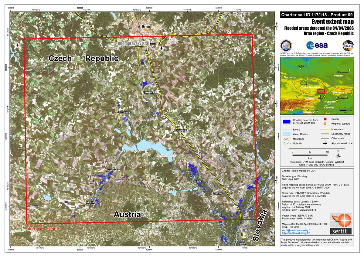
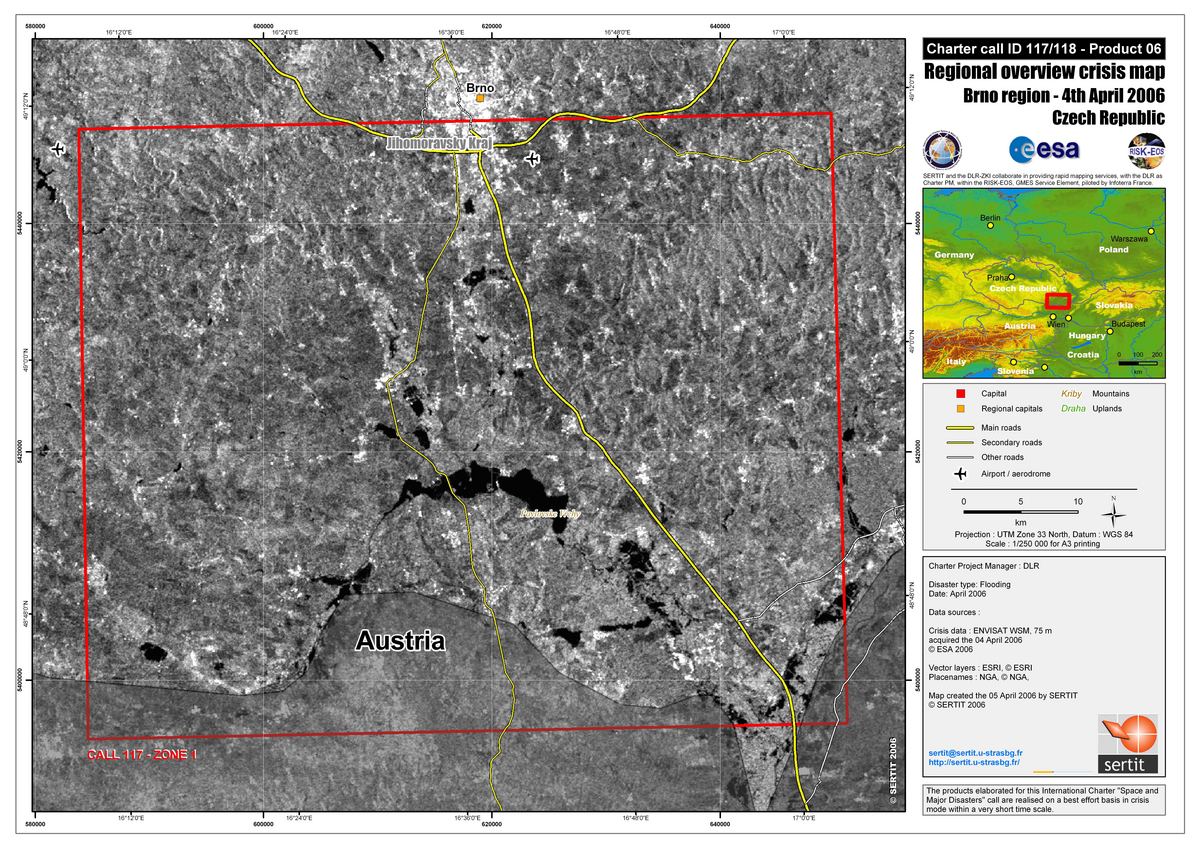
Czech Republic Brno Flood Spacemap, Scale 1:250,000
Copyright: ESA 2006, USGS 2001 Image processing, map created 06/04/2006 by SERTIT in the framework of GMES RISKEOS.
Information about the Product
Acquired: 04/04/2006, 24/05/2001 Event extent map covering the the Brno region in the Czech Republic at 1:250,000. A flood map is superposed on top of Landsat 7 ETM+ data from Maryland GLCF. The extraction and interpretation of the floods were done using ENVISAT Wide Swath Mode data (75m,VV) of 4 April 2006.
Source: Envisat and Landsat 7 ETM+
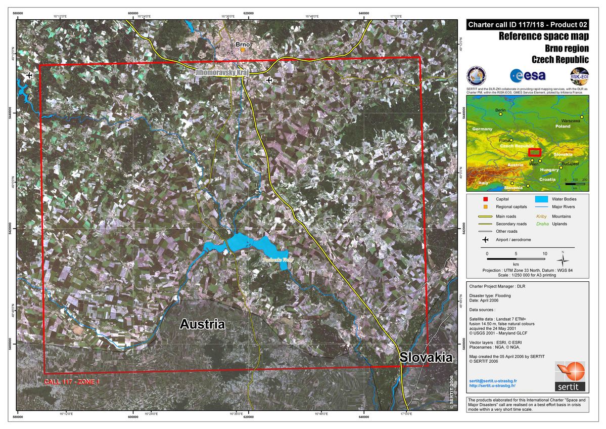
Czech Republic Brno Reference Spacemap, Scale 1:250,000
Copyright: USGS 2001 Image processing, map created 05/04/2006 by SERTIT in the framework of GMES RISKEOS.
Information about the Product
Acquired: 24/05/2001 General overview space map covering the flooded areas of the Czech Republic at 1:1,000,000 using Landsat 7 ETM+ data from Maryland GLCF.
Source: Landsat 7 ETM+

Czech Republic Brno Dyje SPOT-5 Flood Space-map, Scale 1:100,000. Crisis SPOT-5 space-map covering the Dyje River (South of Brno) in the Czech Republic, at 1:250,000, using SPOT-5 data (10 m) of the 8th April 2006.
Copyright: CNES 2006
Image processing, map created 08/04/2006 by SERTIT in the framework of GMES RISKEOS.
Information about the Product
Acquired: 08/04/2006
Source: SPOT-5
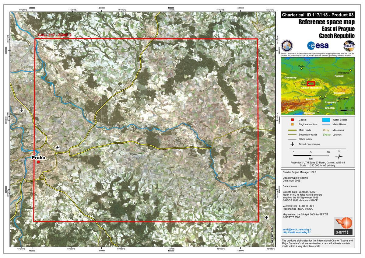
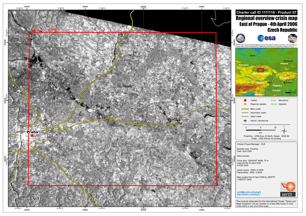
Czech Republic Prague Reference Spacemap, Scale 1:250,000
Copyright: USGS 2001 Image processing, map created 05/04/2006 by SERTIT in the framework of GMES RISKEOS.
Information about the Product
Acquired: 24/05/2001 General overview space map covering the flooded areas of the Czech Republic at 1:1,000,000 using Landsat 7 ETM+ data from Maryland GLCF.
Source: Landsat 7 ETM+

Crisis SPOT-5 space-map covering the Brno area in the Czech Republic, at scale 1:250,000, using SPOT-5 data (10 m) of the 8th April 2006.
Copyright: CNES 2006
Image processing, map created 08/04/2006 by SERTIT in the framework of GMES RISKEOS.
Information about the Product
Acquired: 08/04/2006
Source: SPOT-5
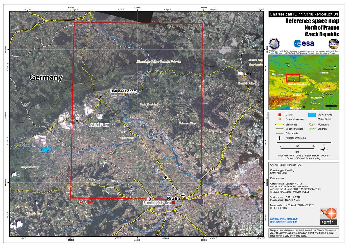
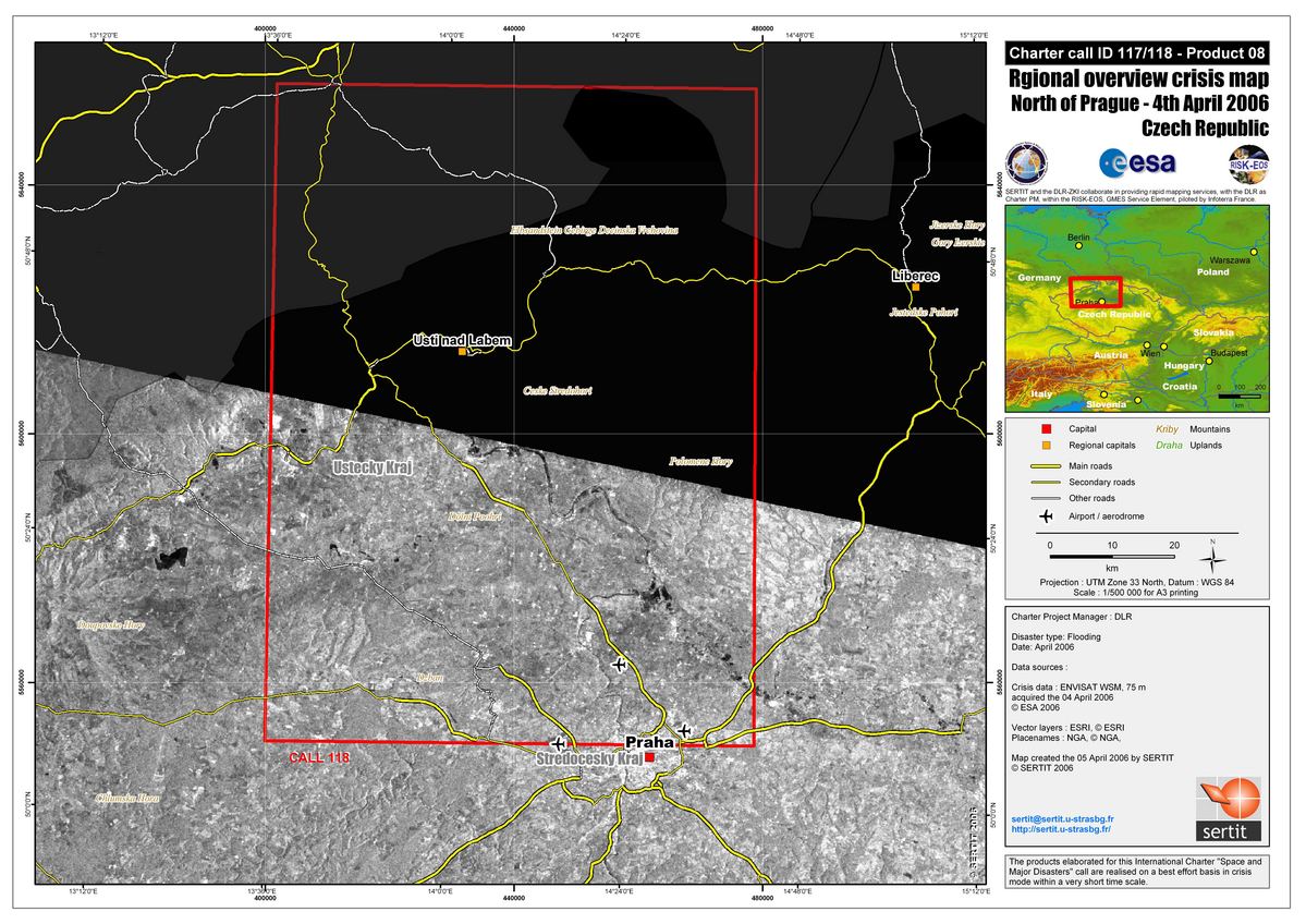
Czech Republic North Prague Reference Spacemap, Scale 1:500,000
Copyright: USGS 2001 Image processing, map created 05/04/2006 by SERTIT in the framework of GMES RISKEOS.
Information about the Product
Acquired: 24/05/2001 General overview space map covering the flooded areas of the Czech Republic at 1:1,000,000 using Landsat 7 ETM+ data from Maryland GLCF.
Source: Landsat 7 ETM+

Crisis SPOT-5 space-map covering the Jihlava and Svratka Rivers (South of Brno) in the Czech Republic, at scale 1:250,000, using SPOT-5 data (10 m) of the 8th April 2006.
Copyright: CNES 2006
Image processing, map created 08/04/2006 by SERTIT in the framework of GMES RISKEOS.
Information about the Product
Acquired: 08/04/2006
Source: SPOT-5

RADARSAT crisis space-map covering the Brno area of the Czech Republic using reference RADARSAT Standard mode image of the 31th August 2001 and crisis RADARSAT Standard mode image of the 09th April 2006, at 1/250,000, using SPOT-5 data (10 m) of the 8th April 2006.
Copyright: Canadian Space Agency 2001, 2006
CNES 2006
Image processing, map created 08/04/2006 by SERTIT in the framework of GMES RISKEOS.
Information about the Product
Acquired: RADARSAT-1: 31/08/2001, 09/04/2006 SPOT-5: 08/04/2006
Source: RADARSAT-1, SPOT-5
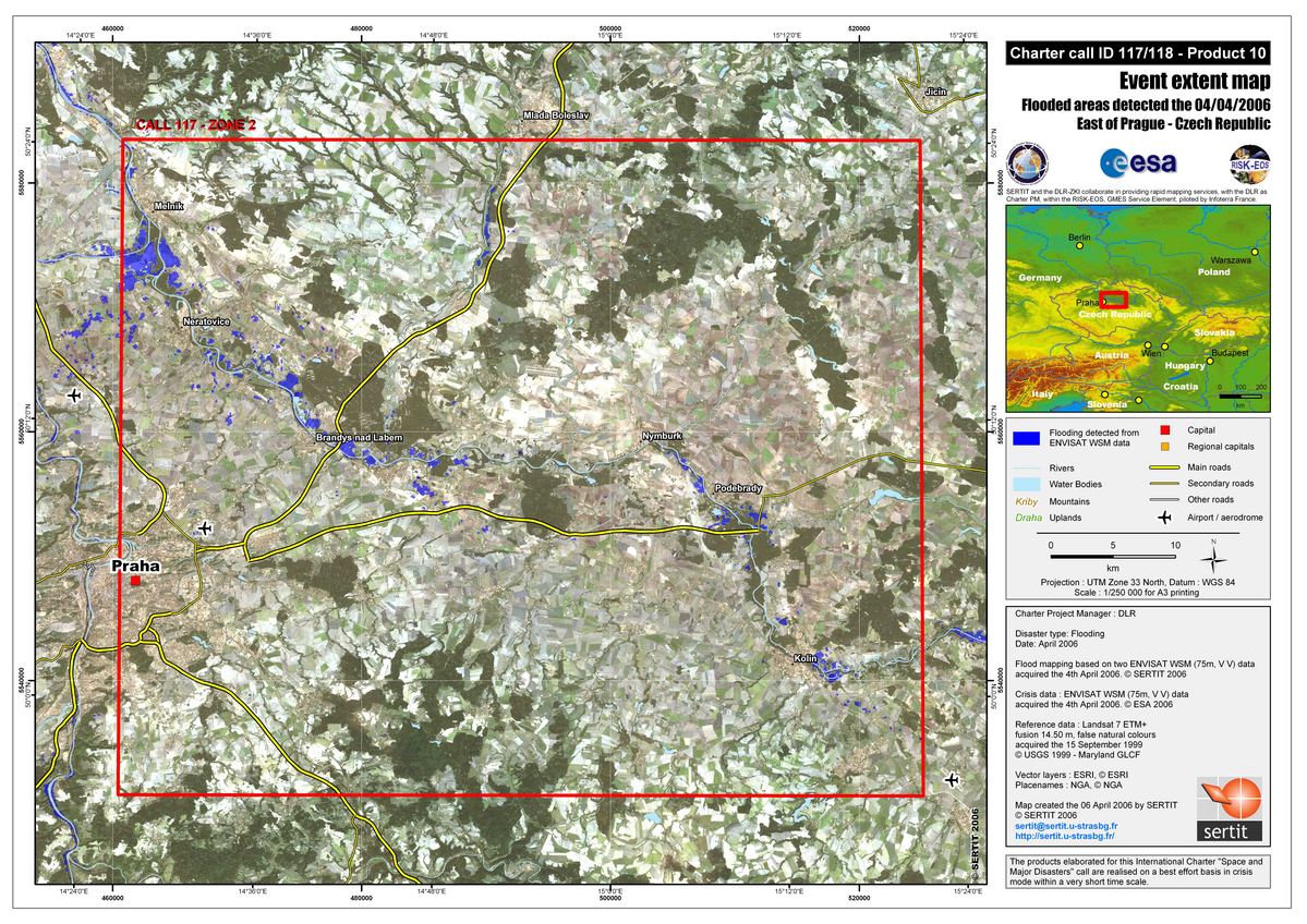
Czech Republic Prague Flood Spacemap, Scale 1:250,000
Copyright: ESA 2006, USGS 2001 Image processing, map created 06/04/2006 by SERTIT in the framework of GMES RISKEOS.
Information about the Product
Acquired: 04/04/2006, 24/05/2001 Event extent map covering the a region east of Prague in the Czech Republic at 1:250,000. A flood map is superposed on top of Landsat 7 ETM+ data from Maryland GLCF. The extraction and interpretation of the floods were done using ENVISAT Wide Swath Mode data (75m,VV) of 4 April 2006.
Source: Envisat and Landsat 7 ETM+

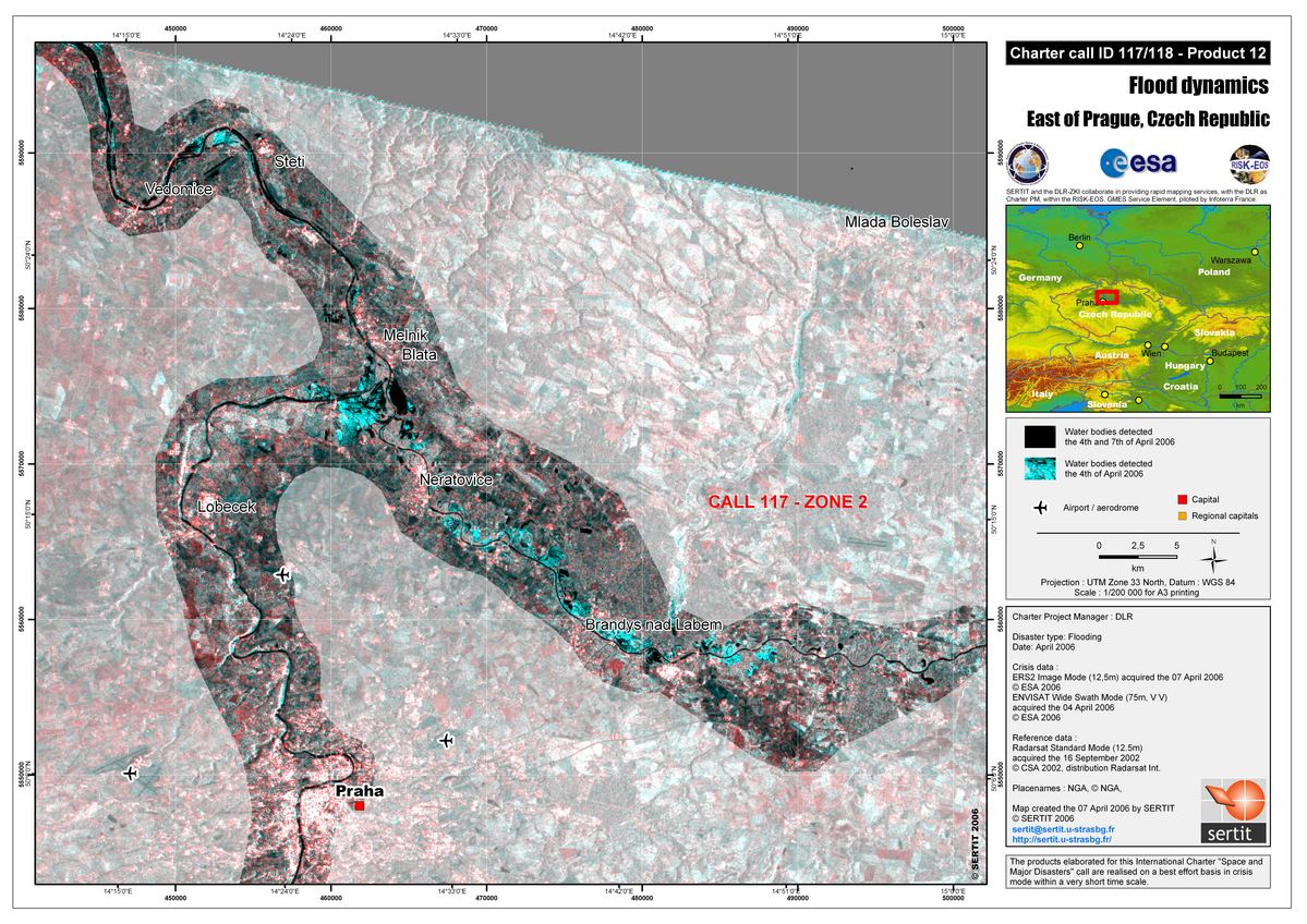
Czech Republic Prague Regional Flood Dynamic Impact Map Scale 1:200,000
Copyright: ESA 2006, Canadian Space Agency 2002. Image processing, map created 08/04/2006 by SERTIT in the framework of GMES RISKEOS.
Information about the Product
Acquired: 07/04/2006, 04/04/2006, 16/04/2002 Dynamic Radar spatio-map covering Elbe and Vltava confluence in the Czech Republic, at 1:200,000, exploiting Radarsat reference data of the 16th April 2002, crisis ENVISAT WSM data of the 4th April 2006 and ERS crisis data of the 07 April 2006.
Source: RADARSAT-1, Envisat, ERS

Czech Republic North Prague Flood Spacemap, Scale 1:150,000
Copyright: ESA 2006, USGS 2001 Image processing, map created 06/04/2006 by SERTIT in the framework of GMES RISKEOS.
Information about the Product
Acquired: 04/04/2006, 24/05/2001 Event extent map covering the a region north of Prague in the Czech Republic at 1:250,000. A flood map is superposed on top of Landsat 7 ETM+ data from Maryland GLCF. The extraction and interpretation of the floods were done using ENVISAT Wide Swath Mode data (75m,VV) of 4 April 2006.
Source: Envisat and Landsat 7 ETM+
Czech Republic Prague Regional Flood Dynamic Map Scale 1:200,000
Copyright: ESA 2006, Canadian Space Agency 2002. Image processing, map created 08/04/2006 by SERTIT in the framework of GMES RISKEOS.
Information about the Product
Acquired: 07/04/2006, 04/04/2006, 16/04/2002 Dynamic Radar spatio-map covering Elbe and Vltava confluence in the Czech Republic, at 1:200,000, exploiting Radarsat reference data of the 16th April 2002, crisis ENVISAT WSM data of the 4th April 2006 and ERS crisis data of the 07 April 2006.
Source: RADARSAT-1, Envisat, ERS

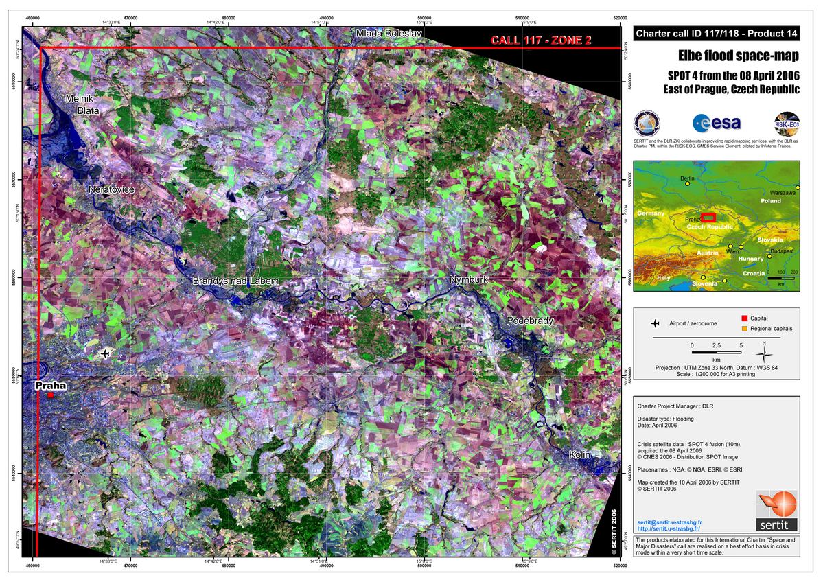
Czech Republic Prague Spot 4 Flood Impact Map Scale 1:200,000
Copyright: CNES 2006 Image processing, map created 11/04/2006 by SERTIT in the framework of GMES RISKEOS.
Information about the Product
Acquired: 08/04/2006 Flood impact map covering the Elbe and Vltava confluence, at 1/200,000, with the flood mapping and interpretation draped over SPOT 4 natural colours data (10 m) of the 8th April 2006.
Source: SPOT-4

Czech Republic Brno SPOT-5 Flood Impact Map Scale 1:250,000. Flood impact map over the Brno area, at 1/200,000, with the flood mapping and interpretation draped over SPOT-5 natural colours data (2.5 m) of the 8th April 2006.
Copyright: CNES 2006
Image processing, map created 11/04/2006 by SERTIT in the framework of GMES RISKEOS.
Information about the Product
Acquired: 08/04/2006
Source: SPOT-5

Czech Republic Prague Spot 4 Flood Dynamic Map Scale 1:200,000
Copyright: CNES 2006, ESA 2006, Canadian Space Agency 2006 Image processing, map created 11/04/2006 by SERTIT in the framework of GMES RISKEOS.
Information about the Product
Acquired: 04-07-08/04/2006 Flood impact map covering the Elbe and Vltava confluence, at 1/200,000, exploiting SPOT 4 data of the 8th April 2006, Radarsat data of the 08th April 2006, ERS data of the 07 April 2006, and ENVISAT WSM data of the 4th April 2006 draped on a SRTM relief map.
Source: SPOT-4, RADARSAT-1, Envisat
 Back to the full activation archive

