 English
 Spanish
 French
 Chinese
 Russian
 Portuguese
 Dernière activation
Charter activations
Typhoon Damrey in Vietnam
Typhoon Damrey battered Vietnam on 04 November. This devastating storm left 27 people dead and 22 missing. Vietnam is susceptible to storms but Accuweather has reported that this was the worst in the area in 16 years.
Damrey made landfall near Nha Trang area at Category 2 strength. Quang Ngai is believed to have been affected the most with an outstanding 580mm of rain since Damrey made landfall.
Heavy rainfall with strong winds of 140 kph flooded the local communities; resulting in damage to buildings and houses, the destruction of 40,000 hectares of crops, and trees and electricity poles were also knocked down. Local authorities have reported that there was an electricity cut and more than 36,000 people in the coastal Can Gio district of Ho Chi Min city were evacuated as a result.
| Type of Event: | Ocean Storm - Typhoon |
| Location of Event: | Vietnam |
| Date of Charter Activation: | 2017-11-06 |
| Time of Charter Activation: | 16:35 |
| Time zone of Charter Activation: | UTC+05:30 |
| Charter Requestor: | UNITAR-UNOSAT on behalf of UNOCHA |
| Activation ID: | 557 |
| Project Management: | UNITAR / UNOSAT |
Products
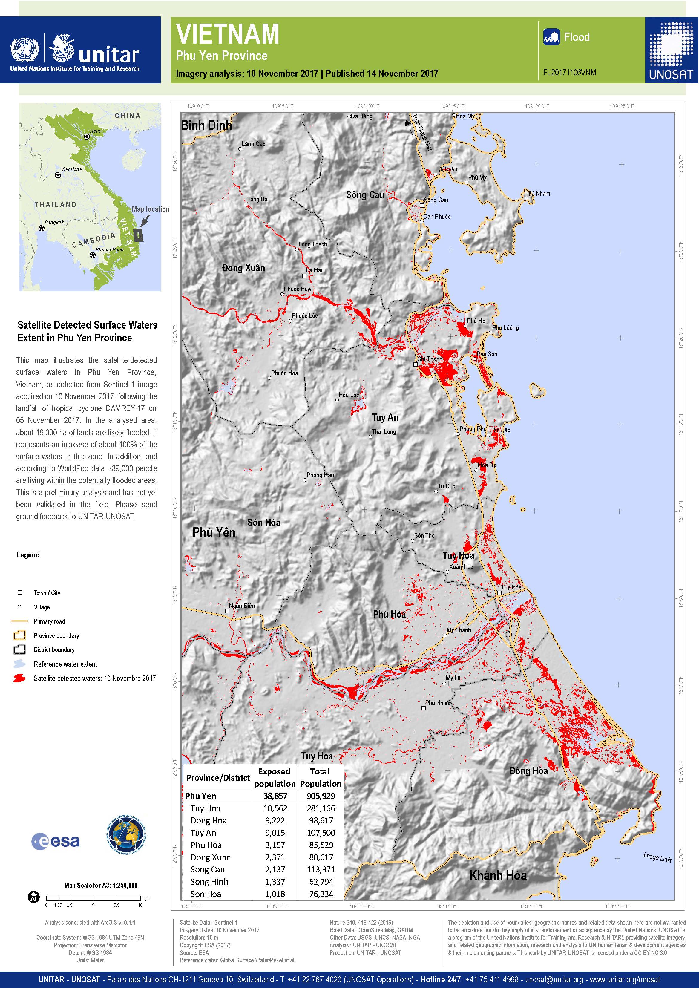
Détection des inondations dans la province de Phu Yen, Vietnam
Copyright: Sentinel-1A © Contient des données Copernicus Sentinel modifiées (2017)
Carte produite par UNITAR / UNOSAT
Information about the Product
Acquired: 10/11/2017
Source: Sentinel-1
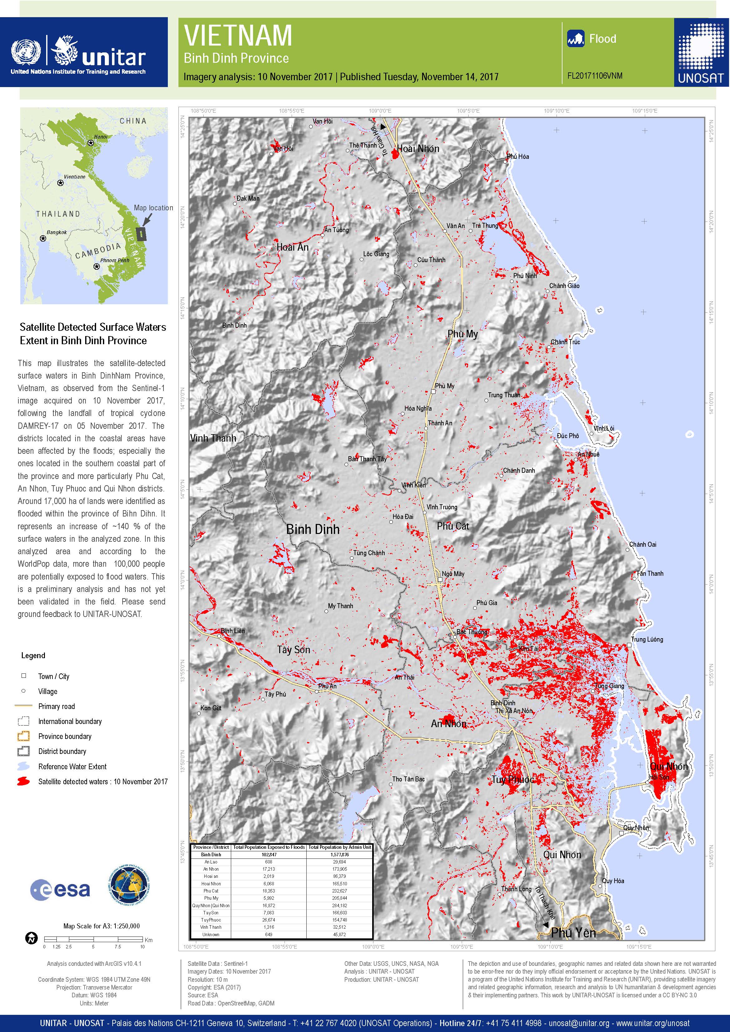
Détection des inondations dans la province de Binh Dinh, Vietnam
Copyright: Sentinel-1A © Contient des données Copernicus Sentinel modifiées (2017)
Carte produite par UNITAR / UNOSAT
Information about the Product
Acquired: 10/11/2017
Source: Sentinel-1

Flooding in the southern part of Vietnam
Copyright: Sentinel-1© Contains modified Copernicus Sentinel data (2017)
Map produced by UNITAR / UNOSAT
Information about the Product
Acquired: 07/11/2017
Source: Sentinel-1
Évaluation préliminaire rapide des inondations dans la province de Quang Binh
Télécharger le rapport complet
Copyright: RADARSAT-2 de données et produits © MacDonald, Dettwiler et Associates Ltd (2017) - Tous droits réservés. RADARSAT est une marque officielle de l'Agence spatiale canadienne.
Sentinel-1 © Copernicus Sentinel data (2017)
Rapport produit par UNITAR/UNOSAT
Information about the Product
Acquired: RADARSAT-2: 07/11/2017
Sentinel-1: 03/11/2017
Source: RADARSAT-2 / Sentinel-1

Eaux de surface détectées par satellite Étendue dans la province de Quang Nam
Copyright: RADARSAT-2 de données et produits © MacDonald, Dettwiler et Associates Ltd (2017) - Tous droits réservés. RADARSAT est une marque officielle de l'Agence spatiale canadienne.
Carte produite par UNITAR-UNOSAT
Information about the Product
Acquired: 07/11/2017
Source: RADARSAT-2
 Back to the full activation archive

