 English
 Spanish
 French
 Chinese
 Russian
 Portuguese
 Última Activación
Charter activations
Typhoon Damrey in Vietnam
Typhoon Damrey battered Vietnam on 04 November. This devastating storm left 27 people dead and 22 missing. Vietnam is susceptible to storms but Accuweather has reported that this was the worst in the area in 16 years.
Damrey made landfall near Nha Trang area at Category 2 strength. Quang Ngai is believed to have been affected the most with an outstanding 580mm of rain since Damrey made landfall.
Heavy rainfall with strong winds of 140 kph flooded the local communities; resulting in damage to buildings and houses, the destruction of 40,000 hectares of crops, and trees and electricity poles were also knocked down. Local authorities have reported that there was an electricity cut and more than 36,000 people in the coastal Can Gio district of Ho Chi Min city were evacuated as a result.
| Type of Event: | Ocean Storm - Typhoon |
| Location of Event: | Vietnam |
| Date of Charter Activation: | 2017-11-06 |
| Time of Charter Activation: | 16:35 |
| Time zone of Charter Activation: | UTC+05:30 |
| Charter Requestor: | UNITAR-UNOSAT on behalf of UNOCHA |
| Activation ID: | 557 |
| Project Management: | UNITAR / UNOSAT |
Products
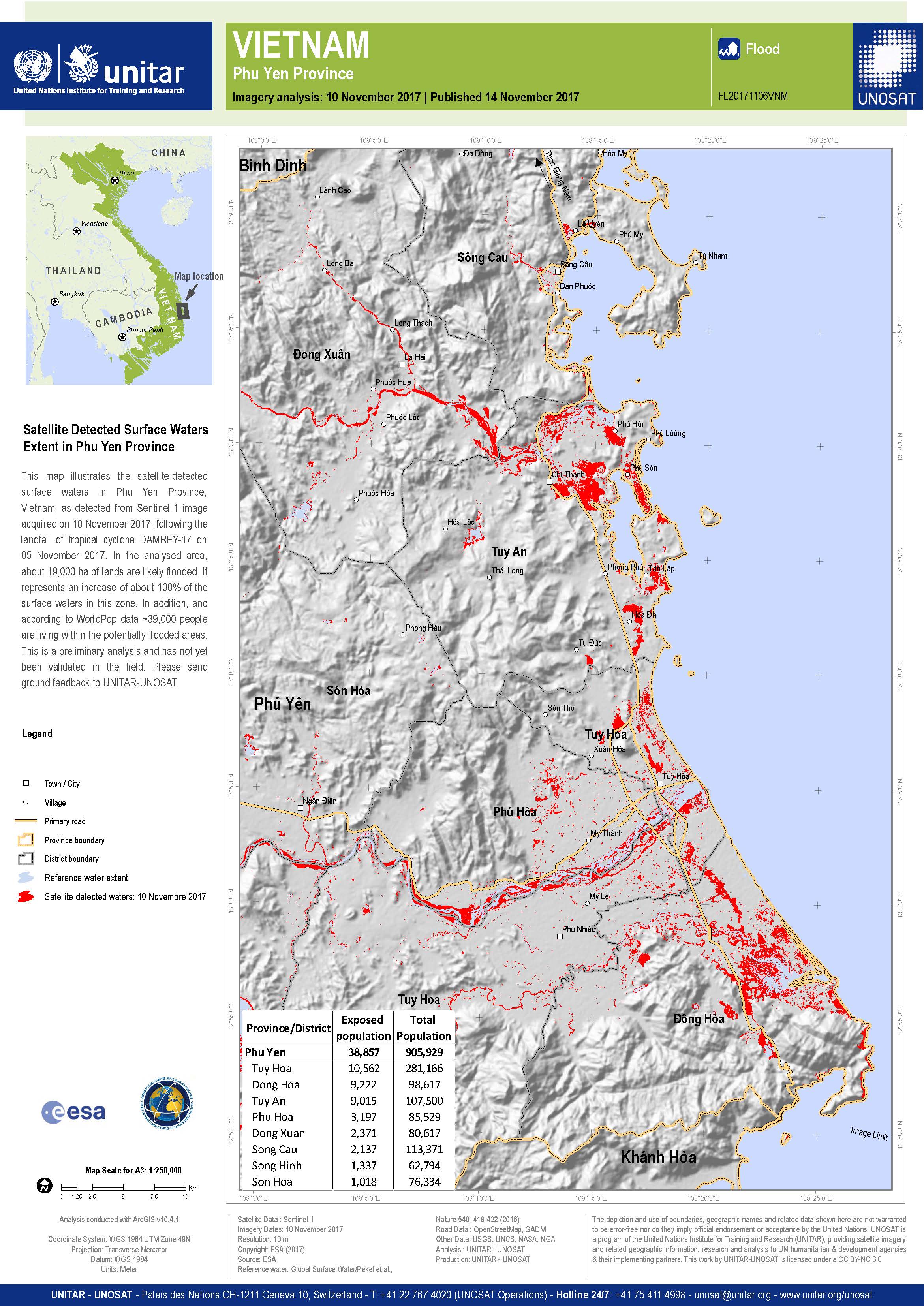
Detección de inundaciones en la provincia de Phu Yen, Vietnam
Copyright: Sentinel-1A © Contiene datos de Copernicus Sentinel modificados
(2017)
Mapa producido por UNITAR / UNOSAT
Information about the Product
Acquired: 10/11/2017
Source: Sentinel-1
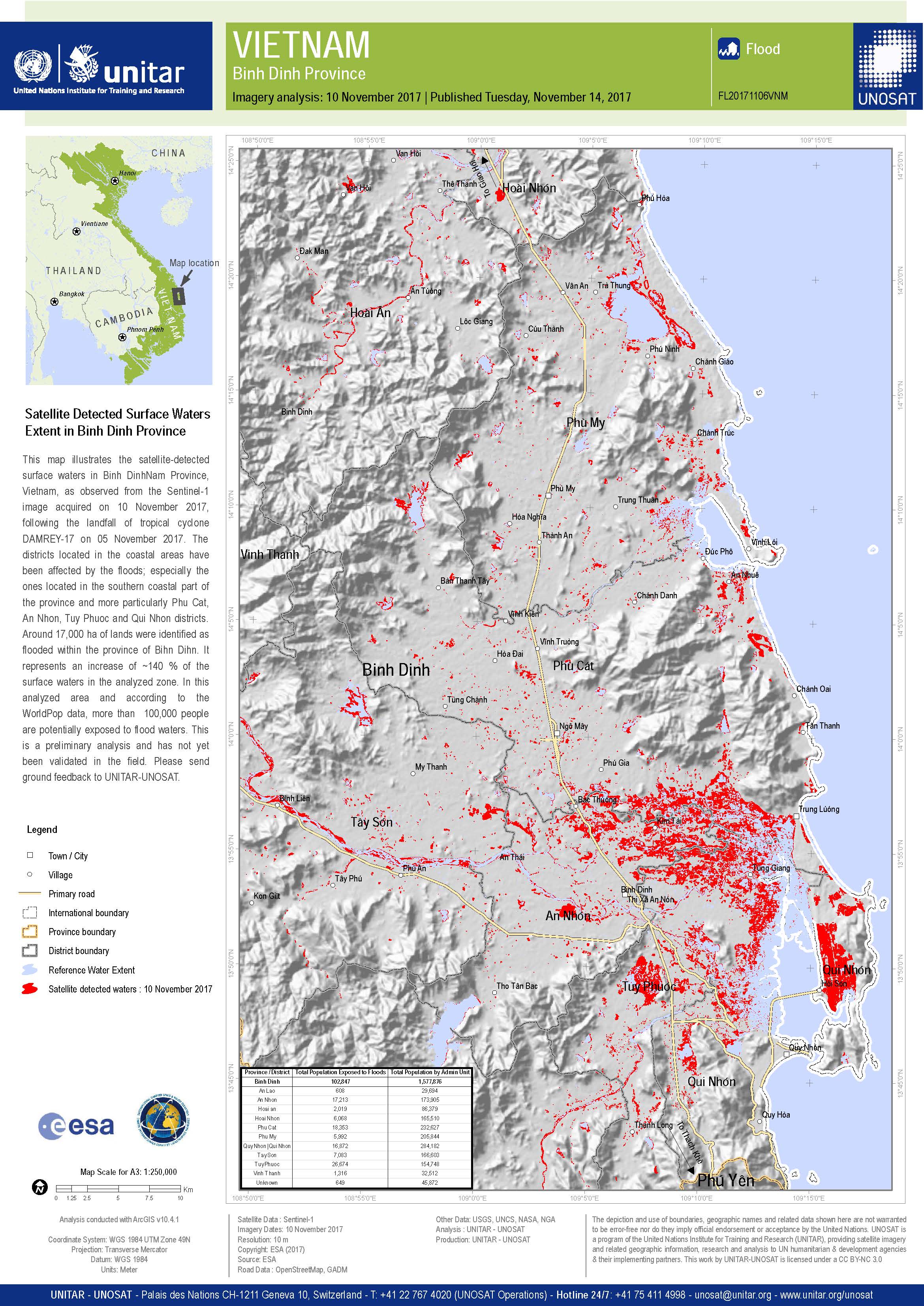
Detección de inundaciones en la provincia de Binh Dinh, Vietnam
Copyright: Sentinel-1A © Contiene datos de Copernicus Sentinel modificados (2017)
Map produced by UNITAR / UNOSAT
Information about the Product
Acquired: 10/11/2017
Source: Sentinel-1

Flooding in the southern part of Vietnam
Copyright: Sentinel-1© Contains modified Copernicus Sentinel data (2017)
Map produced by UNITAR / UNOSAT
Information about the Product
Acquired: 07/11/2017
Source: Sentinel-1
Evaluación preliminar de inundaciones rápidas en la provincia de Quang Binh
Descargue el informe completo
Copyright: RADARSAT-2 de datos y productos © MacDonald, Dettwiler y Asociados SA (2017) - Todos los derechos reservados. RADARSAT es una marca oficial de la Agencia Espacial Canadiense.
Sentinel-1 © Copernicus Sentinel data (2017)
Informe producido por UNITAR/UNOSAT
Information about the Product
Acquired: RADARSAT-2: 07/11/2017
Sentinel-1: 03/11/2017
Source: RADARSAT-2 / Sentinel-1

Aguas superficiales detectadas por satélite Extensión en la provincia de Quang Nam
Copyright: RADARSAT-2 de datos y productos © MacDonald, Dettwiler y Asociados SA (2017) - Todos los derechos reservados. RADARSAT es una marca oficial de la Agencia Espacial Canadiense.
Mapa producido por UNITAR-UNOSAT
Information about the Product
Acquired: 07/11/2017
Source: RADARSAT-2
 Back to the full activation archive

