 English
 Spanish
 French
 Chinese
 Russian
 Portuguese
 Latest Activation
Charter activations
Flood in England
There has been widespread flooding across a number of regions within England during the last 5 days and the event is still ongoing.
Over 900 properties have been flooded and two deaths have been reported. In addition to the flooded properties there has been widespread inundation of agricultural land on floodplains.
Among the affected areas are: Somerset levels, Oxford, Tewkesbury, Darlington to York, Nene Washlands, and Nottingham.
As of 29 November 2012, there have been 1650 flooded properties in total and one further fatality (3 deaths in total).
| Type of Event: | Flood |
| Location of Event: | England, United Kingdom |
| Date of Charter Activation: | 27 November 2012 |
| Charter Requestor: | Environment Agency (of England and Wales) |
| Project Management: | Environment Agency (of England and Wales) |
Products
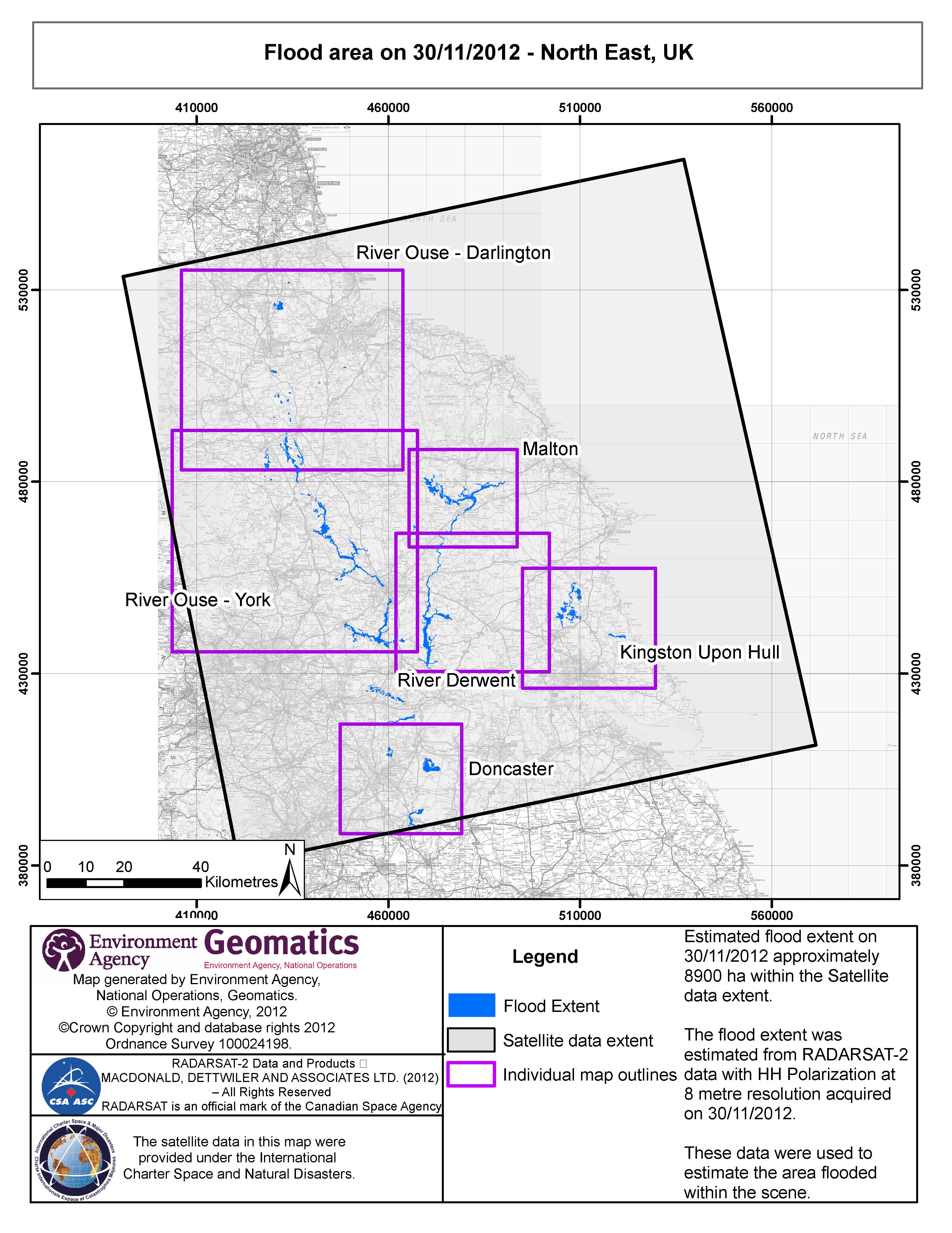
Estimated flood extent on 30/11/2012 approximately 8900 ha within the Satellite data extent.
The flood extent was estimated from RADARSAT-2 data with HH Polarisation at 8 metre resolution.
Copyright: RADARSAT-2 Data and Products © MacDonald, Dettwiler and Associates Ltd. (2012) - All Rights Reserved. RADARSAT is an official trademark of the Canadian Space Agency.
Map produced by Environment Agency, National Operations, Geomatics
Information about the Product
Acquired: 30/11/2012
Source: RADARSAT-2
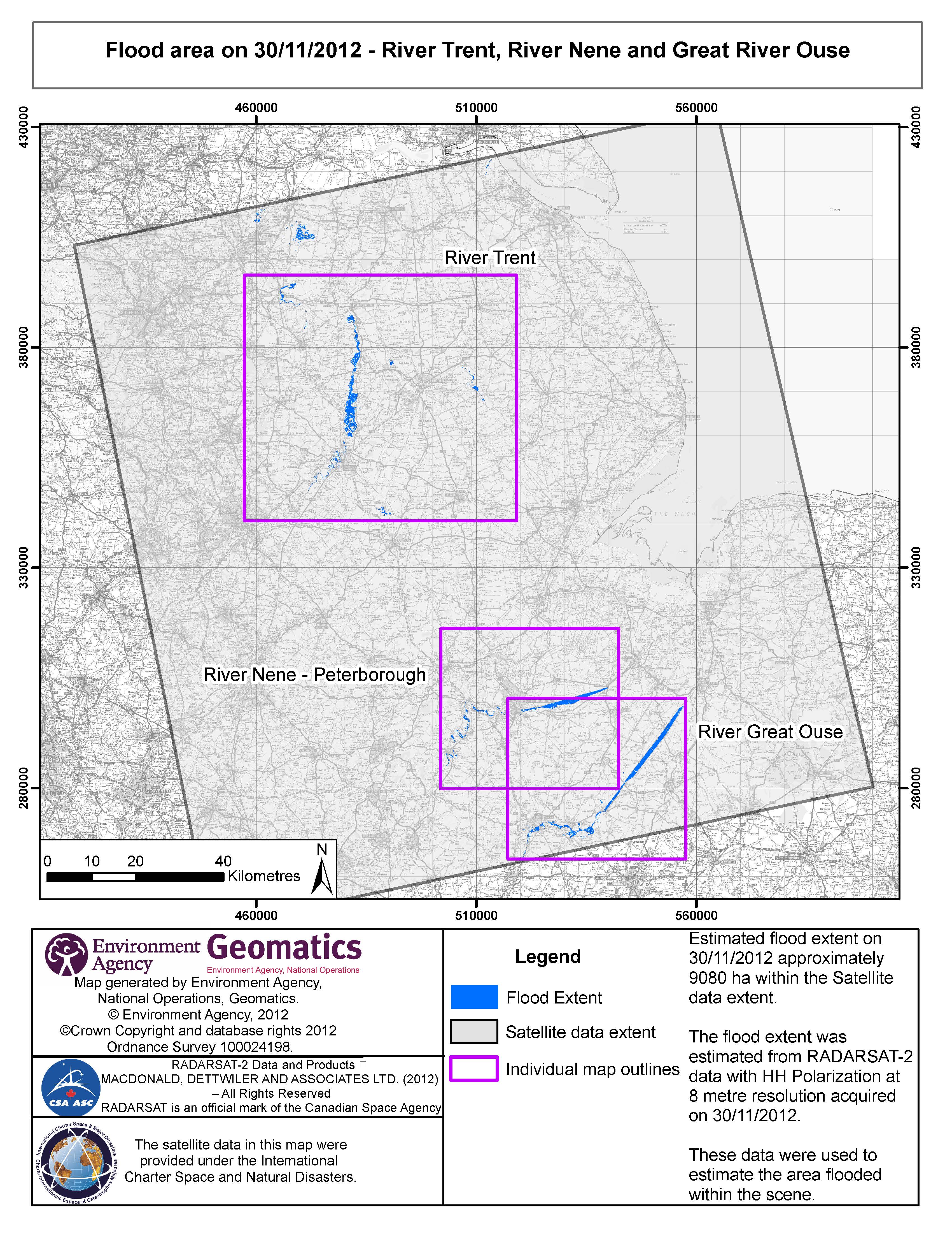
Estimated flood extent on 30/11/2012 approximately 9080 ha within the Satellite data extent.
The flood extent was estimated from RADARSAT-2 data with HH Polarisation at 8 metre resolution.
Copyright: RADARSAT-2 Data and Products © MacDonald, Dettwiler and Associates Ltd. (2012) - All Rights Reserved. RADARSAT is an official trademark of the Canadian Space Agency.
Map produced by Environment Agency, National Operations, Geomatics
Information about the Product
Acquired: 30/11/2012
Source: RADARSAT-2
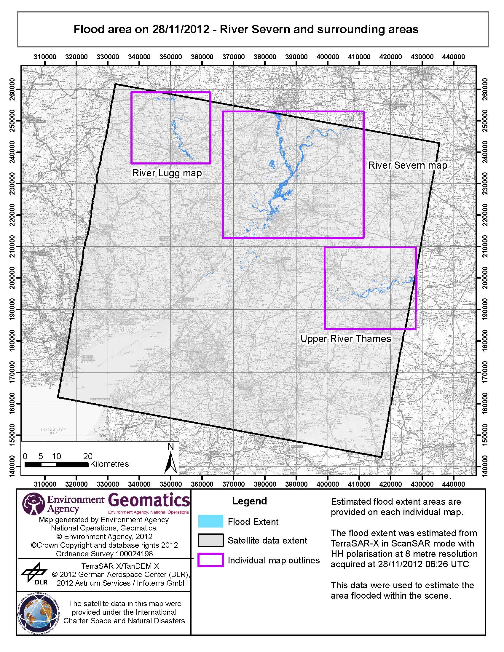
Estimated flood extent areas are provided on each map.
The flood extent was estimated from TerraSAR-X in ScanSAR mode with HH polarisation at 8 meter resolution.
Copyright: TerraSAR-X/TanDEM-X © 2012 German Aerospace Center (DLR), 2012 Astrium Services / Infoterra GmbH
Map produced by Environment Agency, National Operations, Geomatics
Information about the Product
Acquired: 28/11/2012
Source: TerraSAR-X
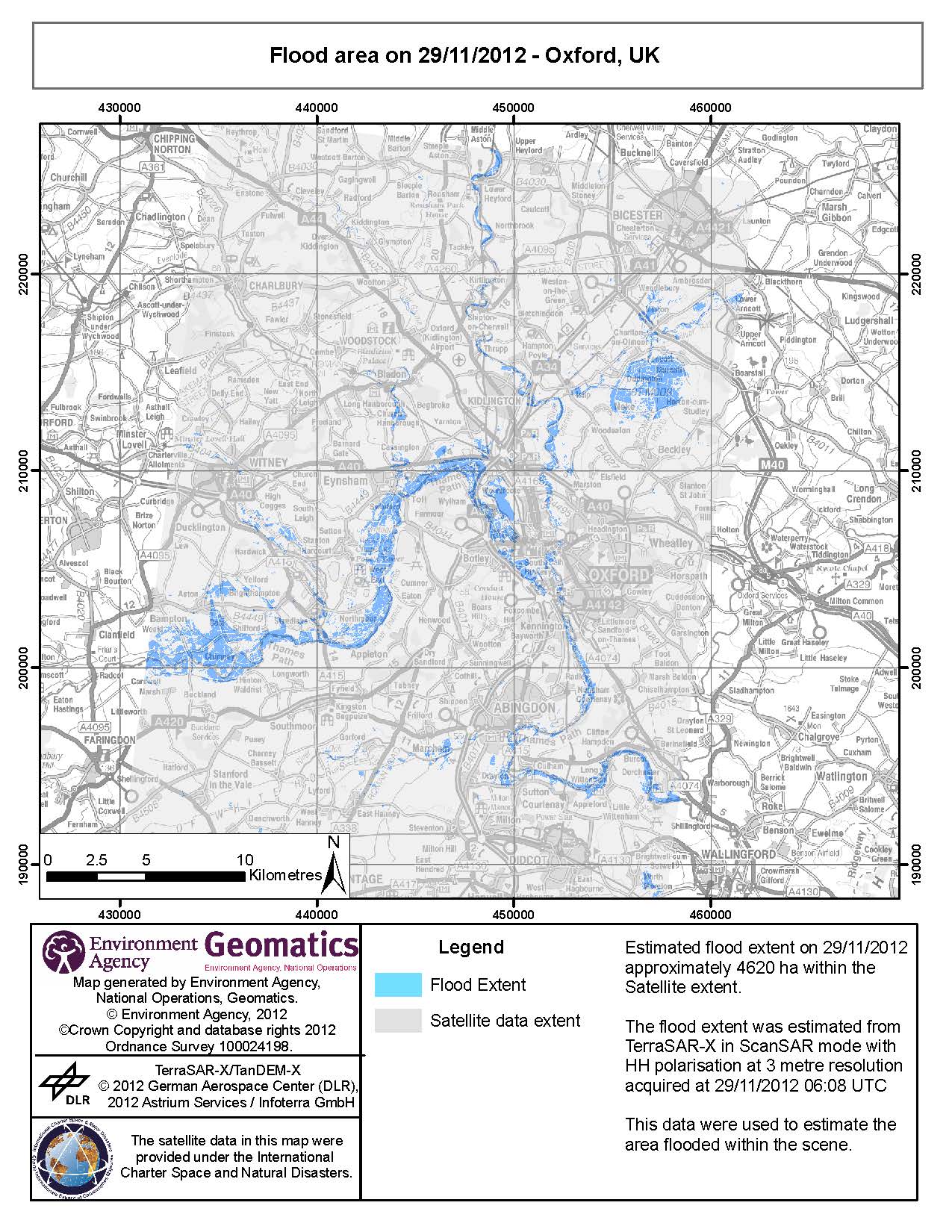
Estimated flood extent on 29/11/2012 - approximately 4620 ha within the Satellite extent.
The flood extent was estimated from TerraSAR-X in ScanSAR mode with HH polarisation at 3 metre resolution.
Copyright: TerraSAR-X/TanDEM-X © 2012 German Aerospace Center (DLR), 2012 Astrium Services / Infoterra GmbH
Map produced by Environment Agency, National Operations, Geomatics
Information about the Product
Acquired: 29/11/2012
Source: TerraSAR-X

Flood area on 28/11/2012 - Somerset Levels, UK
Aerial photography campaign overlaid
Copyright: TerraSAR-X/TanDEM-X © 2012 German Aerospace Center (DLR), 2012 Astrium Services / Infoterra GmbH
Map produced by Environment Agency, National Operations, Geomatics
Information about the Product
Acquired: Pre-crisis: 08/04/2010
Post-crisis: 23/11/2012, 26/11/2012 and 28/11/2012
Source: TerraSAR-X
 Back to the full activation archive

