 English
 Spanish
 French
 Chinese
 Russian
 Portuguese
 最新宪章启动
Charter activations
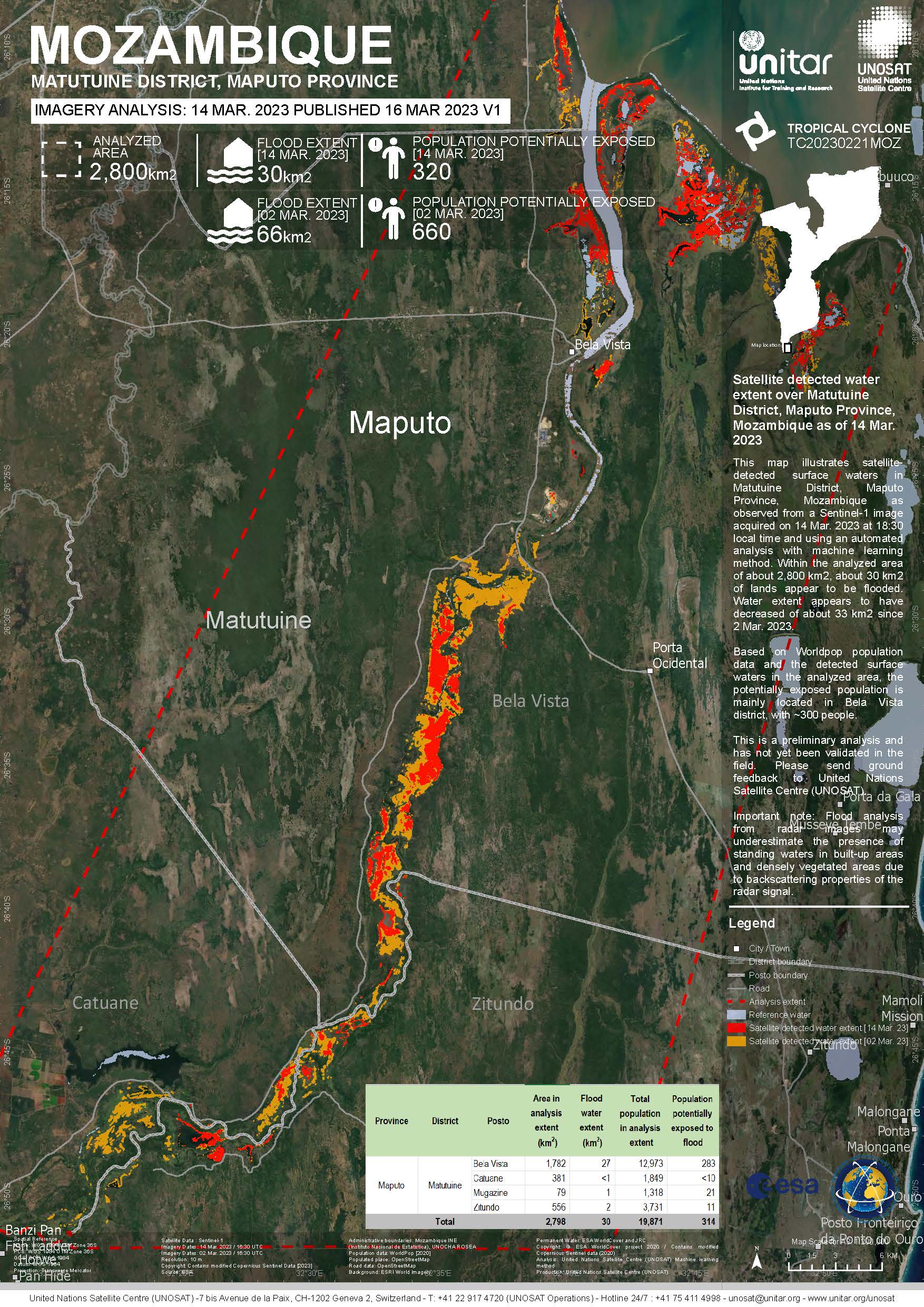
Tropical Storm Freddy in Mozambique
Tropical Storm Freddy made landfall in Vilankulo district, Inhambane province on 24 February, reaching Mozambique as a moderate tropical storm, with winds of 95 km/h, and further weakened to tropical storm with winds of 55km/h in the course of 25 February.
Freddy tracked across seven districts in Inhambane (Funhalouro, Govuro, Inhassoro, Mabote, Massinga, Morrumbene, Vilankulo) and the district of Gaza (Chigubo), an area where close to one million people live.
The National Institute of Meteorology (INAM) warned that rainfall above 200 mm per day would affect Gaza, Manica, Inhambane, and Sofala over the period 25-27 February.
Widespread damage to public infrastructure and services were reported, including over one thousand schools, many health units and close to four thousand kilometres of roads. Damages to road infrastructure severely affected movement across the country which has had a serious impact on economic activity such as trade.
Some centralized water supply systems and an unknown number of water sources have been damaged leaving thousands of people with no access to safe water.
Related News and Resources:
| 事件类型: | Tropical Storm |
| 事件地点: | Mozambique |
| 启动宪章的日期: | 2023-02-24 |
| 宪章启动时间: | 16:18 |
| 宪章启动时区: | UTC+01:00 |
| 宪章要求者: | UNITAR on behalf of United Nations Office for the Coordination of Humanitarian Affairs (OCHA) ¦ Regional Office for Southern & Eastern Africa |
| 启动ID: | 805 |
| 项目经理: | Jakrapong Tawala (UNITAR) |
| act-value-adders: | NOAA VA (NOAA) Alisson Oliveira (INPE) |
Products
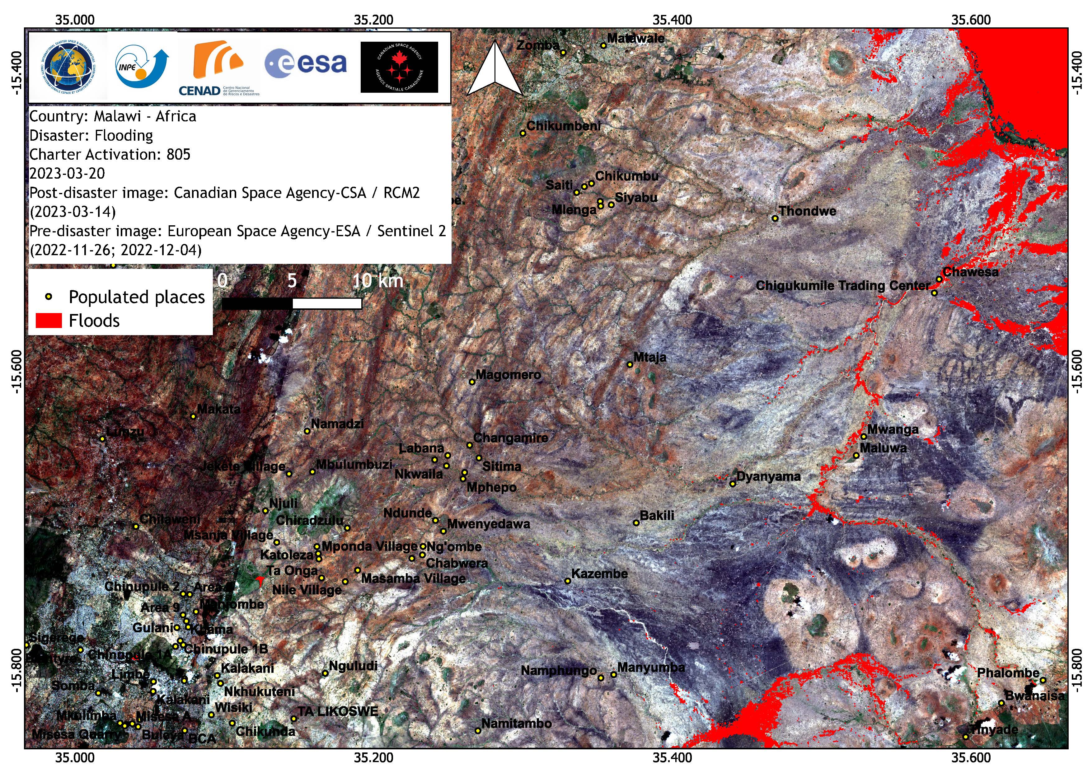
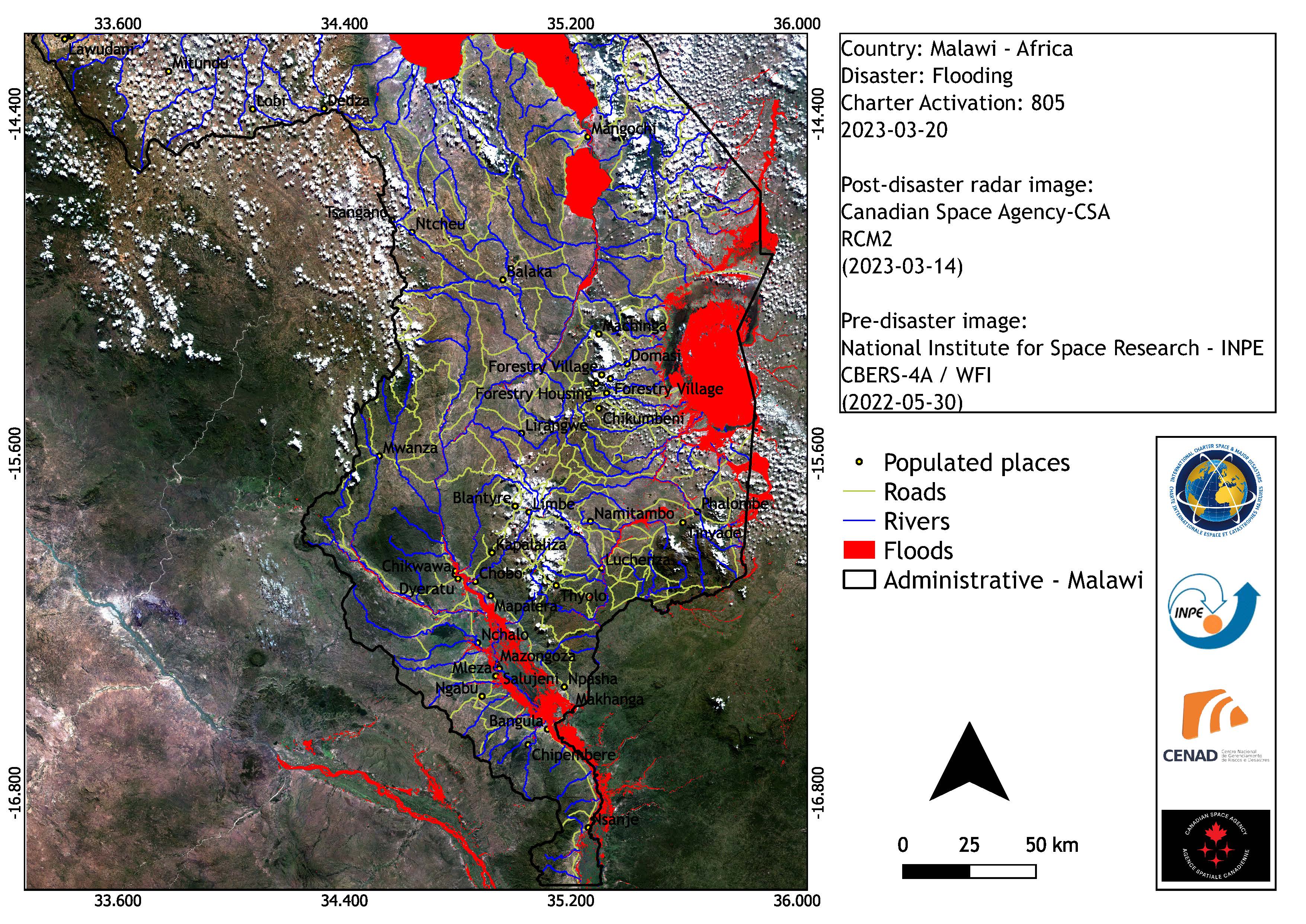
Floods in Malawi
版权: RADARSAT Constellation Mission Imagery © Government of Canada (2023) - RADARSAT is an official mark of the Canadian Space Agency
Contains modified Copernicus Sentinel data (2023)
Map produced by CENAD
Information about the Product
已获得: RCM:14/03/2023
Sentinel-2: 26/11/2022, 04/12/2022
源: RCM / Sentinel-2
类别: Reference Map
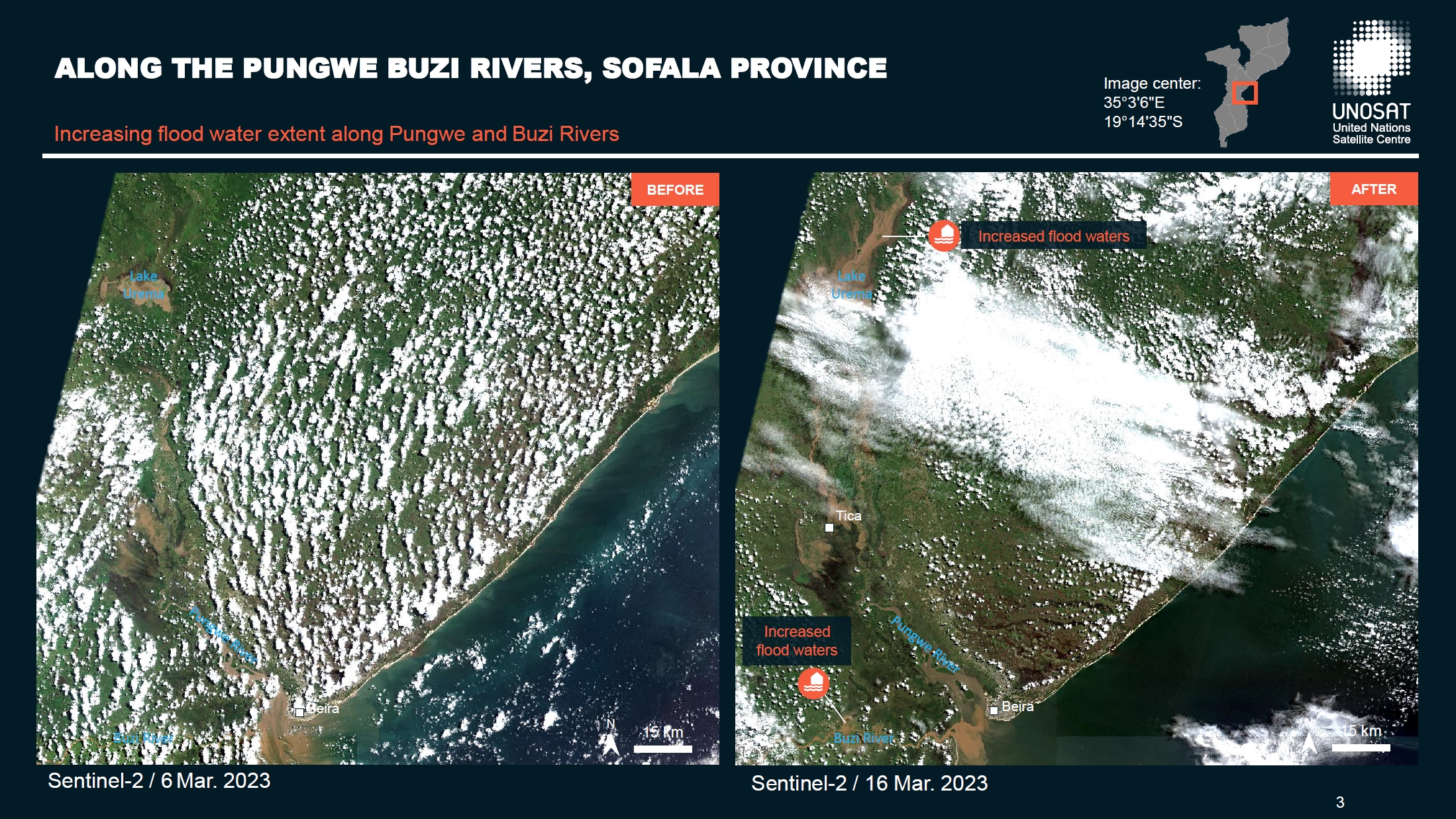
Preliminary satellite-flood assessment report in the Nhamatanda, Dondo, Cidade Da Beira and Buzi Districts, Sofala Province, Mozambique
Download full report
版权: Contains modified Copernicus Sentinel data (2023)
Report produced by UNITAR/UNOSAT
Information about the Product
已获得: 02/10/2022, 07/10/2022, 05/01/2023, 20/01/2023, 07/02/2023, 06/03/2023 and 16/03/2023
源: Sentinel-2
类别: Dossier

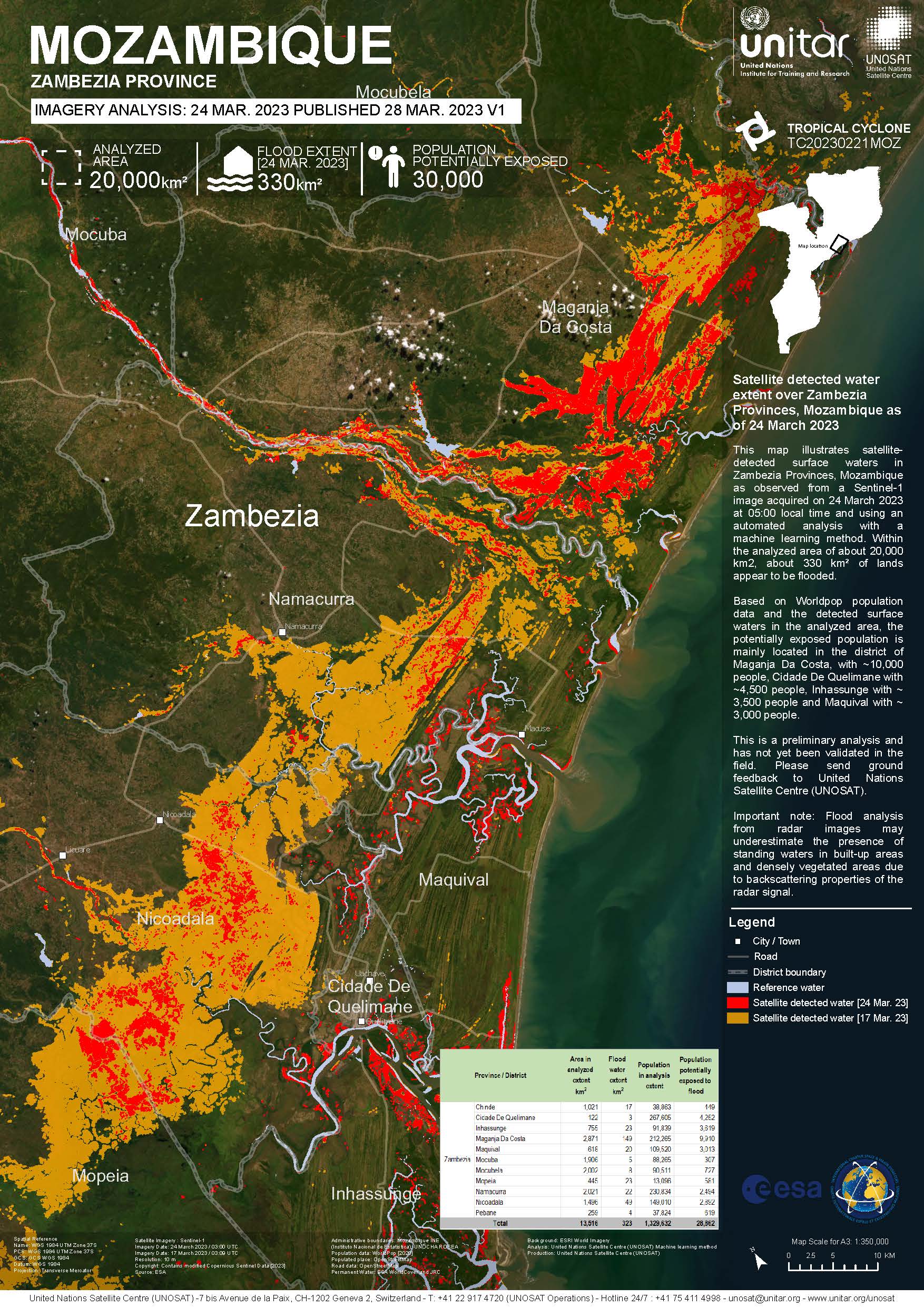
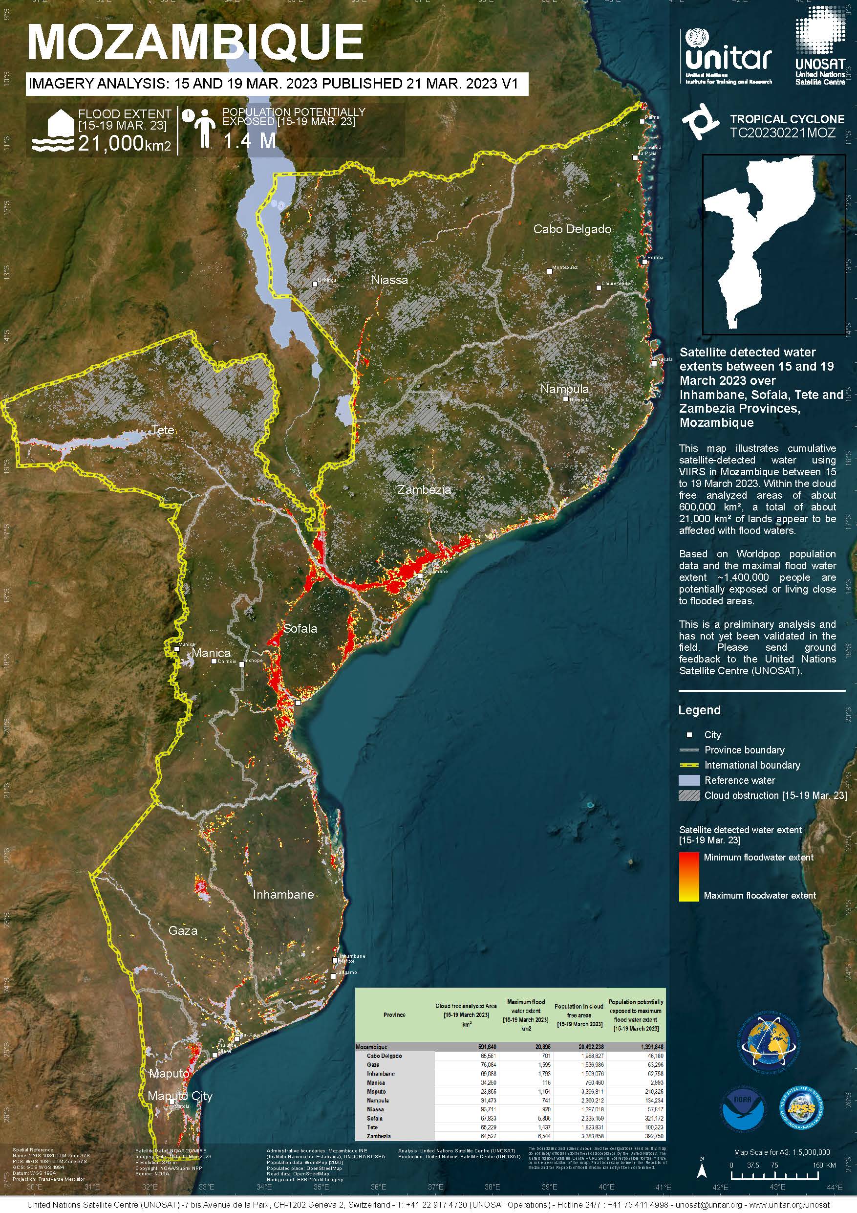
Satellite detected water extent and evolution over the Southern Region in the Malawi, Tete and Zambezia Provinces, Mozambique between 14 and 17 March 2023
版权: Contains modified Copernicus Sentinel data (2023)
RADARSAT Constellation Mission Imagery © Government of Canada (2023) - RADARSAT is an official mark of the Canadian Space Agency
Map produced by UNITAR and UNOSAT
Information about the Product
已获得: RCM: 14/03/2023
Sentinel-1: 17/03/2023
源: Sentinel-1 / RCM
类别: Delineation Monitoring Maps
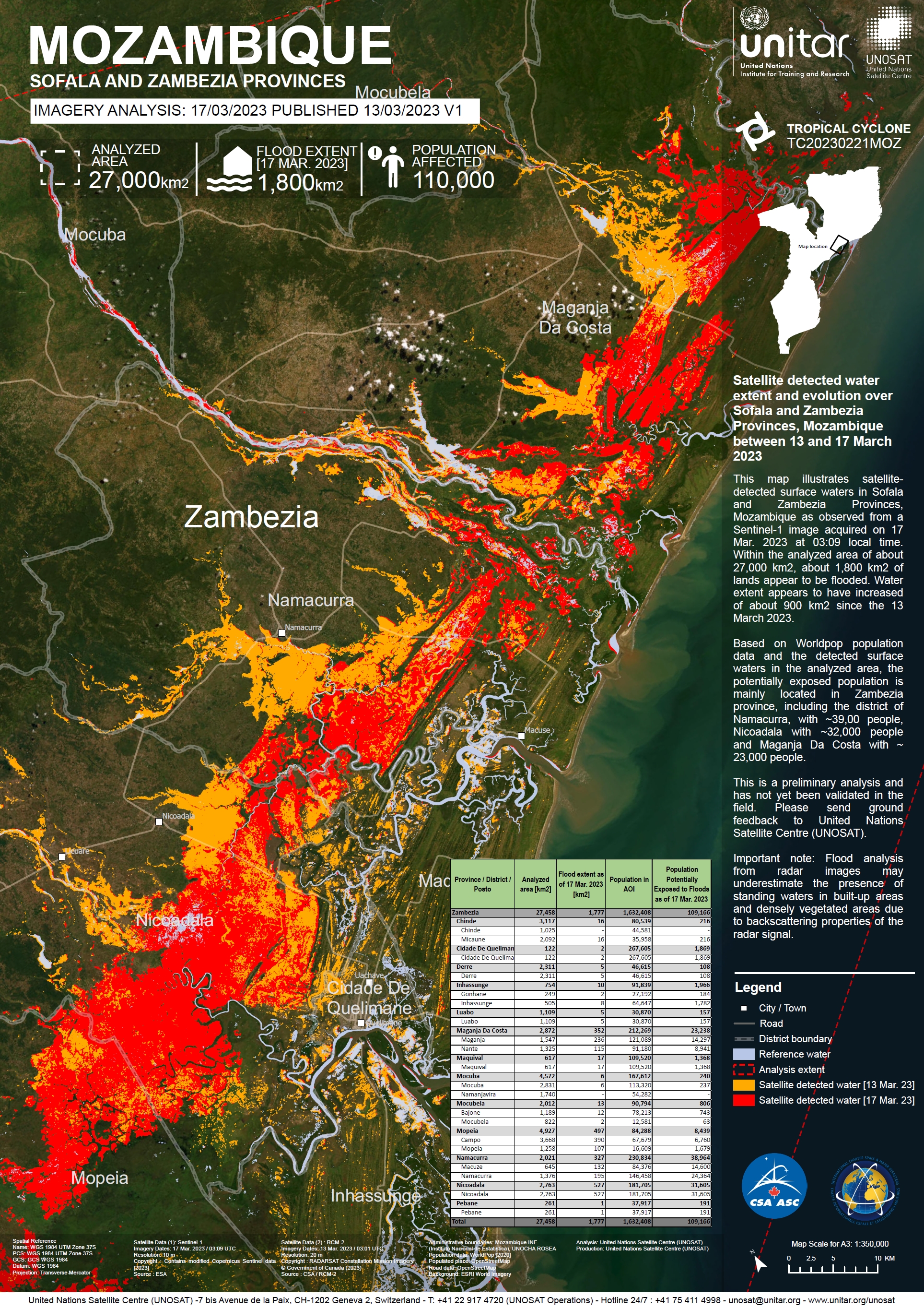
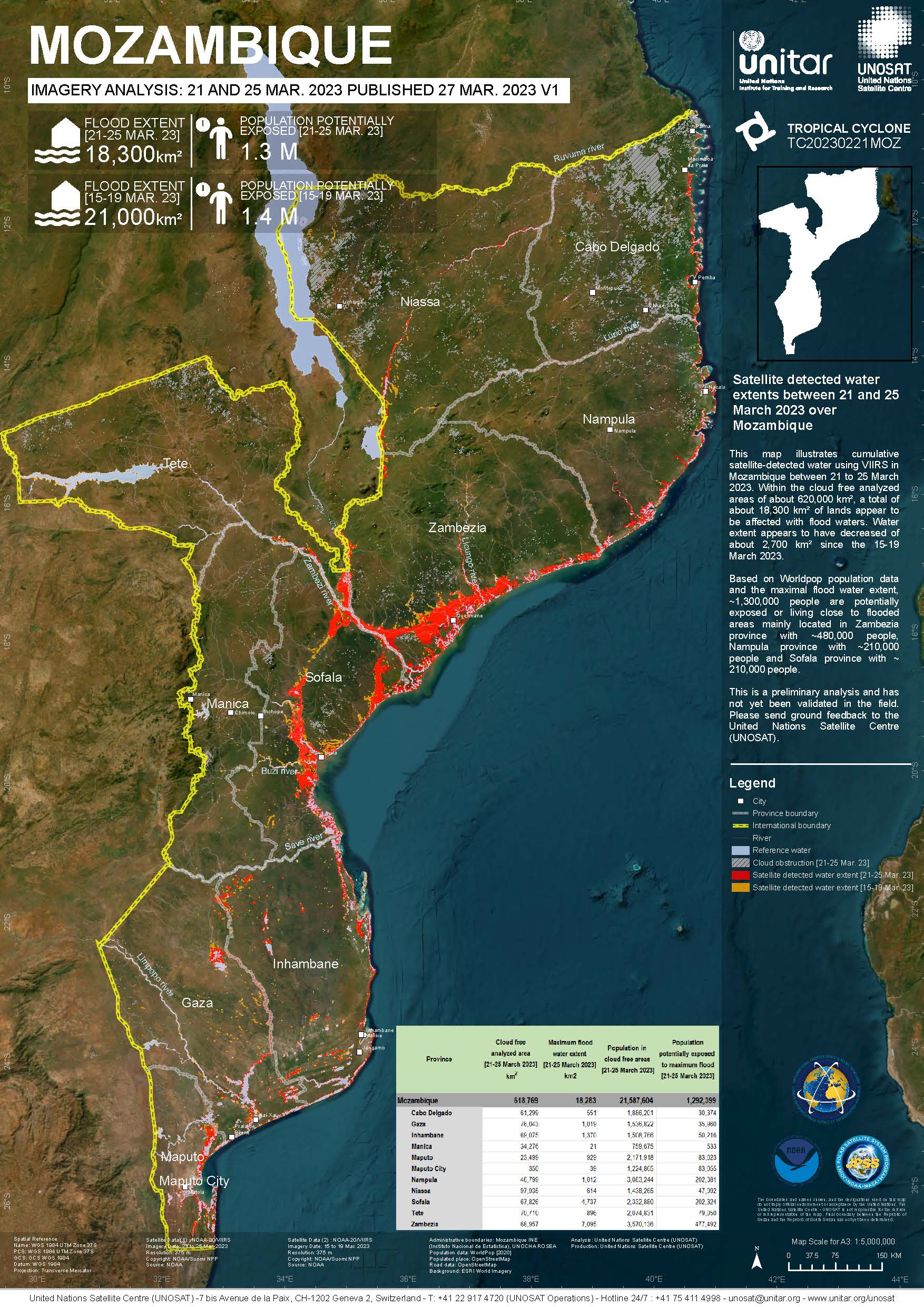
Satellite detected water extent and evolution over Sofala and Zambezia Provinces, Mozambique between 13 and 17 March 2023
版权: Contains modified Copernicus Sentinel data (2023)
RADARSAT Constellation Mission Imagery © Government of Canada (2023) - RADARSAT is an official mark of the Canadian Space Agency
Map produced by UNITAR and UNOSAT
Information about the Product
已获得: RCM: 13/03/2023
Sentinel-1: 17/03/2023
源: Sentinel-1 and RCM
类别: Delineation Map
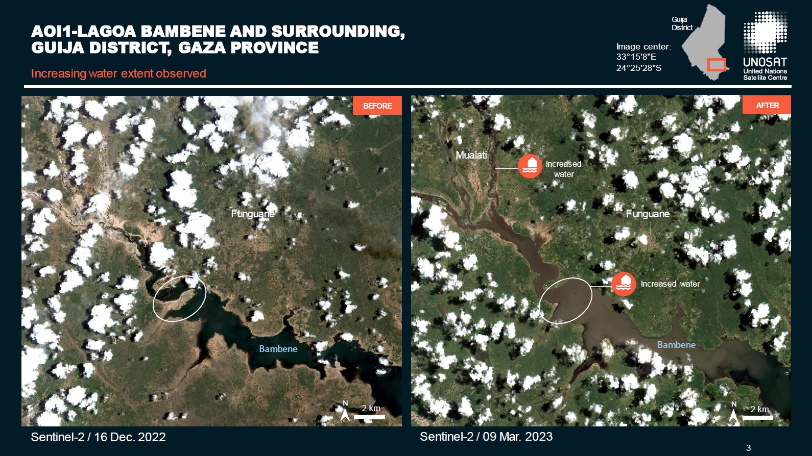
Preliminary satellite-flood assessment report in Lagoa Bambene and surrounding, Guija District, Gaza Province, Mozambique
Download full report
版权: Contains modified Copernicus Sentinel data (2022)
Report produced by UNITAR / UNOSAT
Information about the Product
已获得: 09/03/2023, 14/03/2023 and 16/12/2022
源: Sentinel-2
类别: Dossier
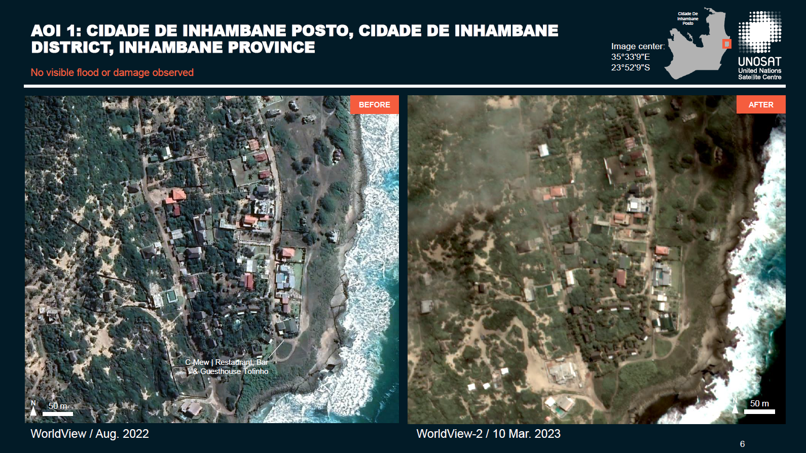
Preliminary Satellite Flood Assessment Report in Cidade De Inhambane District, Inhambane Provinces, Mozambique
Download Full Report
版权: © DigitalGlobe, Inc. (2023), Longmont CO USA 80503. DigitalGlobe and the DigitalGlobe logos are trademarks of DigitalGlobe, Inc.
The use and/or dissemination of this data and/or of any product in any way derived there from are restricted. Unauthorized use and/or dissemination is prohibited.
© Airbus Defence and Space Limited (2023)
Report prepared by UNITAR and UNOSAT
Information about the Product
已获得: Vision-1: 04/03/2023, 05/03/2023
WorldView-2: 10/03/2023
源: Vision-1 and WorldView-2
类别: Dossier
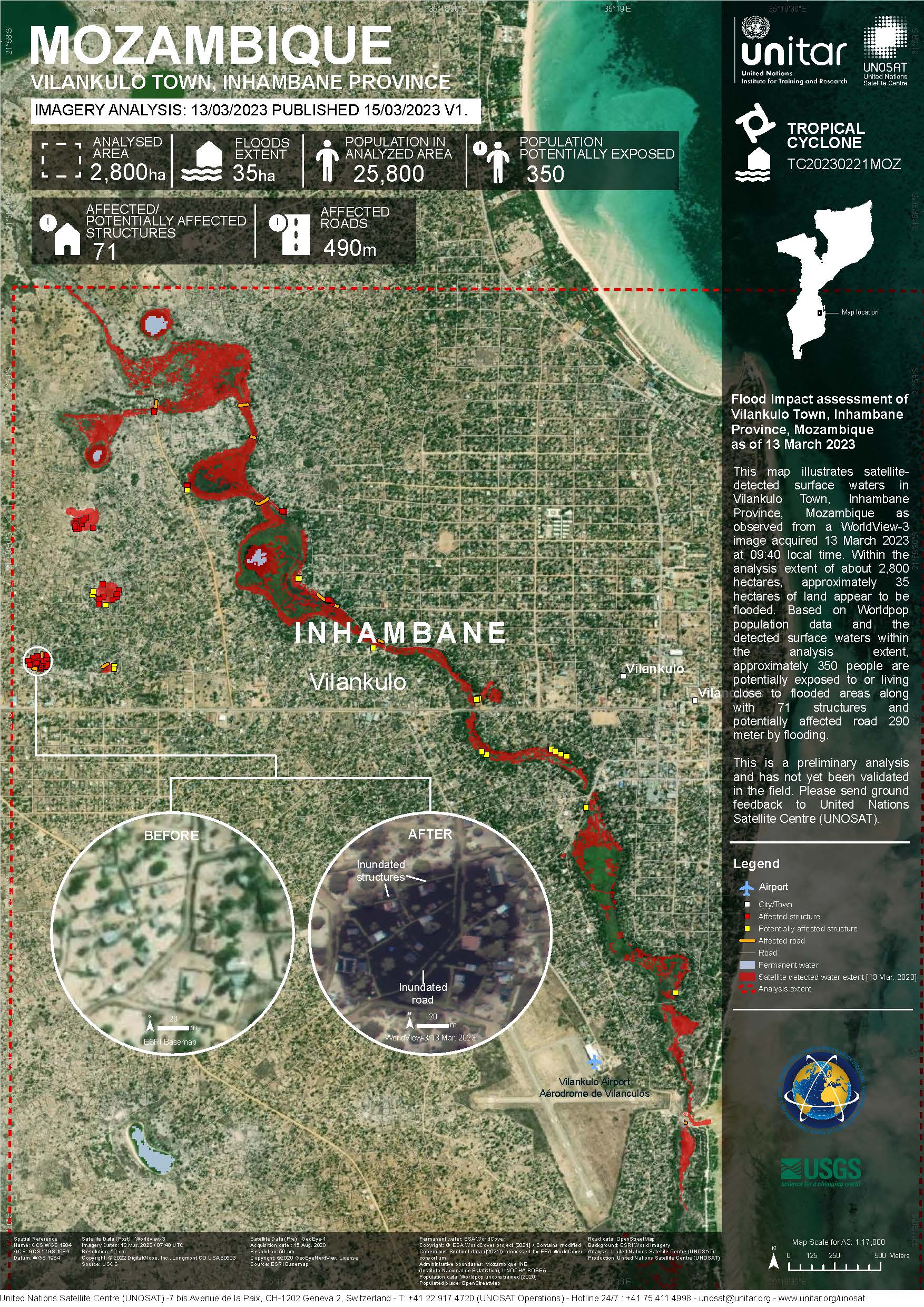
Flood Impact assessment of Vilankulo Town, Inhambane Province, Mozambique
版权: © (2023) DigitalGlobe, Inc., Longmont CO USA 80503. DigitalGlobe and the DigitalGlobe logos are trademarks of DigitalGlobe, Inc. The use and/or dissemination of this data and/or of any product in any way derived there from are restricted. Unauthorized use and/or dissemination is prohibited
Includes Pleiades material © CNES (2023), Distribution Airbus DS.
Map produced by UNITAR / UNOSAT
Information about the Product
已获得: Pleiades: 06/03/2023, 07/03/2023, 09/03/2023 and 10/03/2023
WorldView-3: 13/03/2023
源: WorldView-3 / Pleiades
类别: Delineation Map
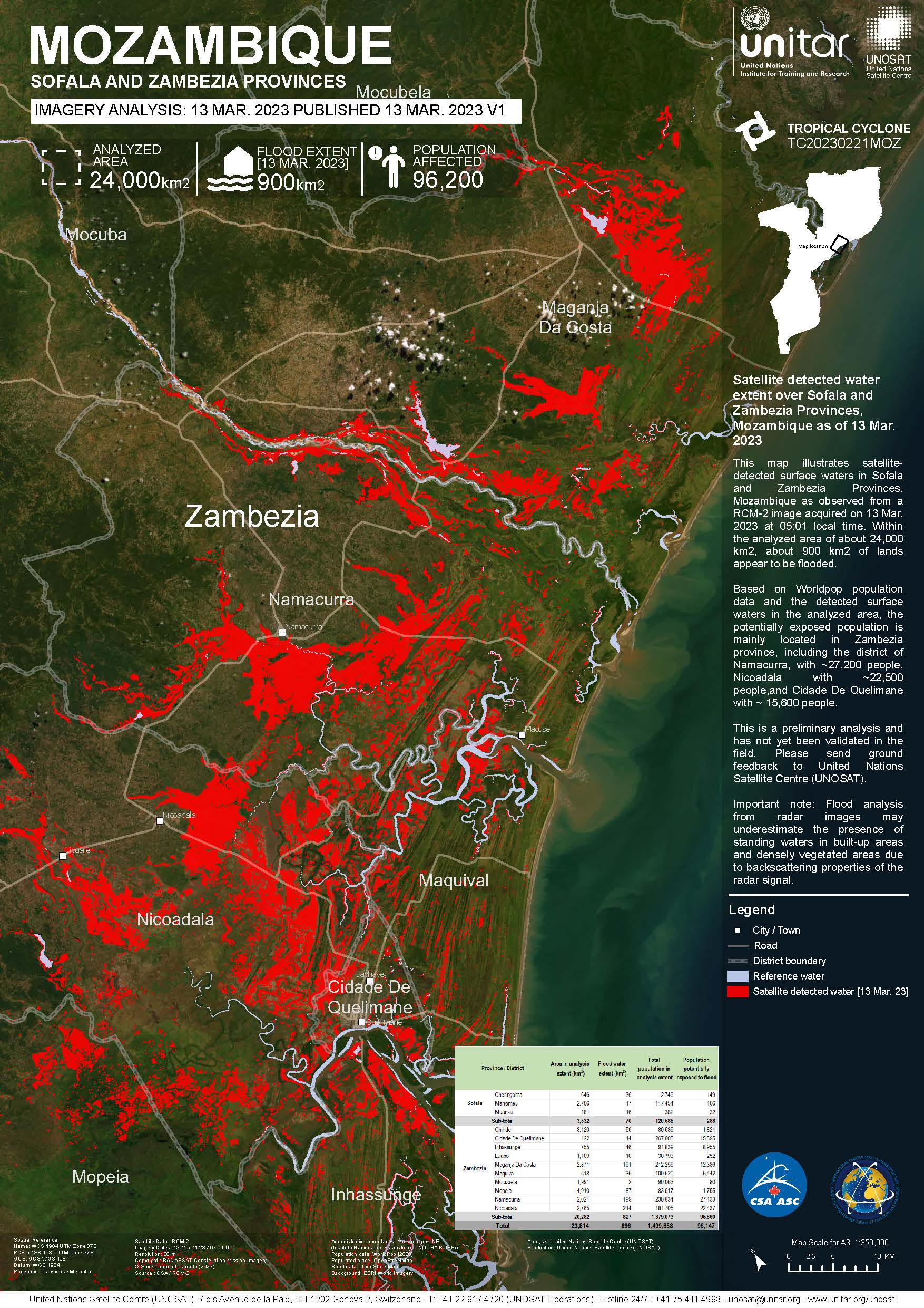
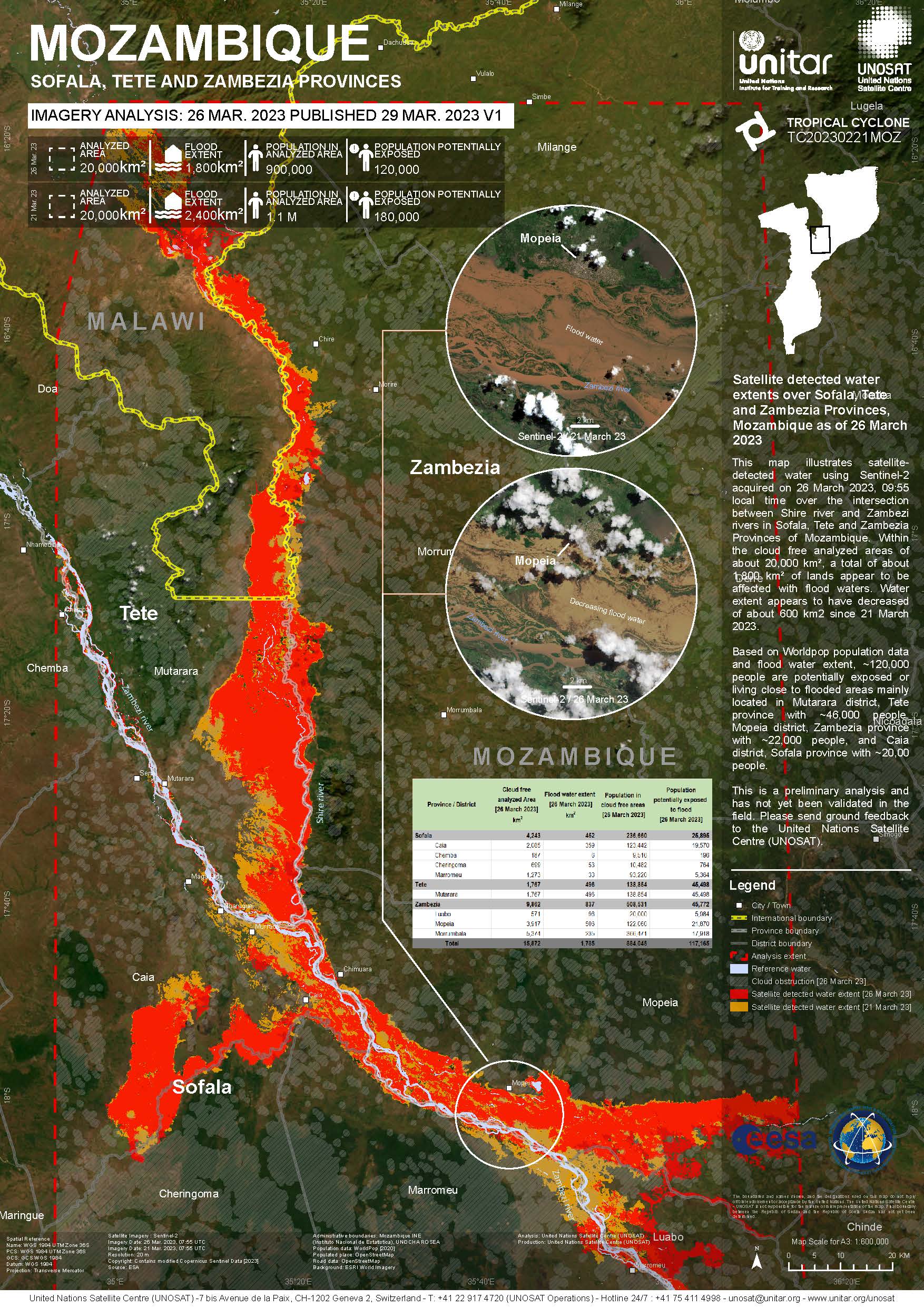
Satellite detected water extent over Sofala and Zambezia Provinces, Mozambique.
版权: RADARSAT Constellation Mission Imagery © Government of Canada (2023) - RADARSAT is an official mark of the Canadian Space Agency
Map produced by UNITAR / UNOSAT
Information about the Product
已获得: 13/03/2023
源: RCM
类别: Reference Map

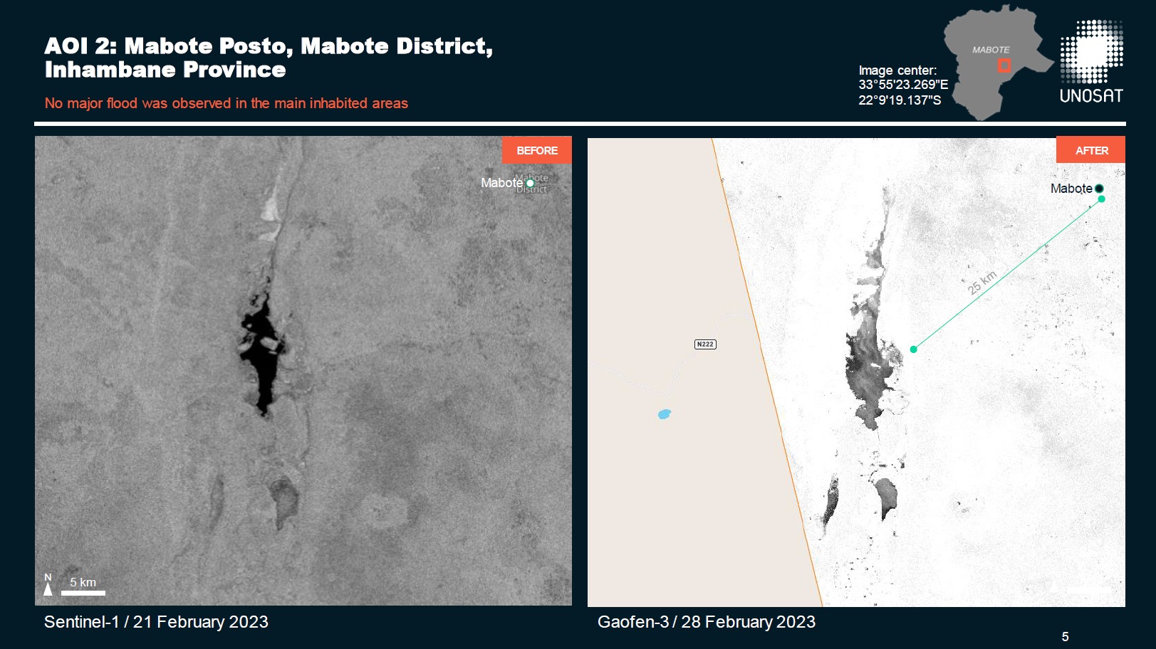
Preliminary satellite-flood assessment report in Inhambane and Sofala Provinces, Mozambique
Download full report
版权: RADARSAT Constellation Mission Imagery © Government of Canada (2023) - RADARSAT is an official mark of the Canadian Space Agency
© CNSA/CRESDA (2023)
Contains modified Copernicus Sentinel data (2023)
Report produced by UNITAR/UNOSAT
Information about the Product
已获得: Sentinel-1: 21/02/2023
RCM: 27/02/2023, 01/03/2023
Gaofen-3 : 28/02/2023
源: Gaofen-3 (GF-3) / RCM / Sentinel-1
类别: Dossier
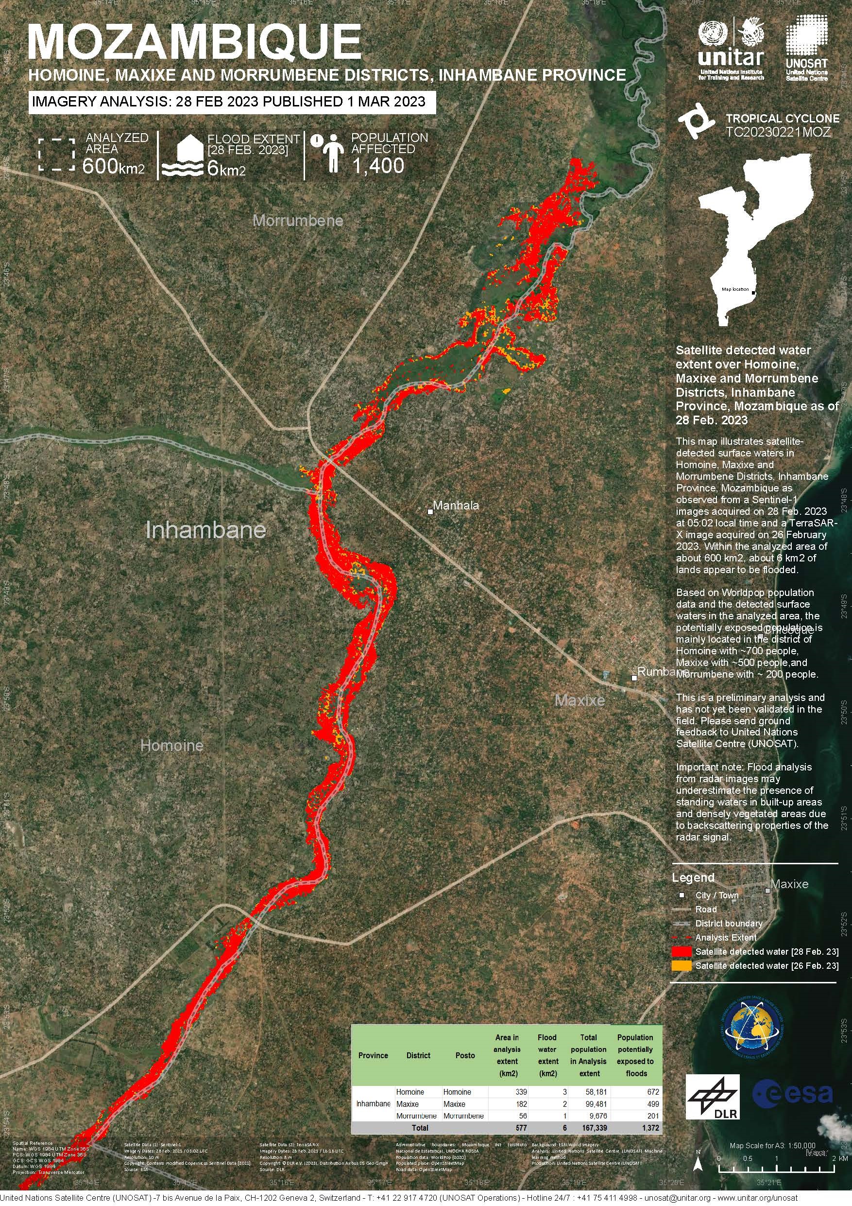
Satellite detected water extent over Homoine, Maxixe and Morrumbene Districts, Inhambane Province, Mozambique
版权: © DLR e.V. (2023), Distribution Airbus DS Geo GmbH
Contains modified Copernicus Sentinel data (2023)
Map produced by UNITAR / UNOSAT
Information about the Product
已获得: TerraSAR-X: 26/02/2023
Sentinel-1: 28/02/2023
源: TerraSAR-X / Sentinel-1
类别: Delineation Map
 返回完整的响应档案
