 English
 Spanish
 French
 Chinese
 Russian
 Portuguese
 最新宪章启动
Charter activations
越南洪水
此次暴雨淹没了越南北部地区,造成至少17人死亡,淹没成千上万的家庭。
据报道,暴雨开始于7月26日,是该地区四十年内经历的最为严重的暴雨。
受灾地区主要是越南北部海岸广宁省,包括夏浪,锦普,汪秘,东潮,云屯和横蒲等城市都遭遇洪水袭击。
在一些地区,洪水已达到2米的高度,促使救援工作向安全地点疏散数百名居民。据估计,3000多个家庭受洪水影响。
由于洪水,很多地点很难到达,许多道路被淹没,暴雨还导致该省山区的滑坡,这些滑坡破坏了几十个家庭。
天气预报目前估计,暴雨将持续到8月的第一周,可能造成进一步的洪水和滑坡。
| 事件类型: | 洪水 |
| 事件地点: | 越南 |
| 启动宪章的日期: | 2015年7月30日 |
| 宪章启动时间: | 16:00:00 |
| 宪章启动时区: | UTC+02:00 |
| 宪章要求者: | UNITAR/UNOSAT代表UN ESCAP |
Products

Overview of flood waters in Hai Phong Province, Vietnam
版权: Landsat 7 data and products © USGS (2015) - All rights reserved
TerraSAR-X © German Aerospace Center (DLR), 2015 Airbus Defence and Space / Infoterra GmbH
Map produced by UNITAR/UNOSAT
Information about the Product
已获得: Landsat 7: 05/10/2009
TerraSAR-X: 02/08/2015
源: Landsat 7 / TerraSAR-X

Overview of flood waters along northern coast, Quang Ninh Province, Vietnam
版权: RADARSAT-2 Data and Products © MacDonald, Dettwiler and Associates Ltd. (2015) - All Rights Reserved. RADARSAT is an official trademark of the Canadian Space Agency.
Map produced by UNITAR/UNOSAT
Information about the Product
已获得: Pre-disaster: 28/03/2015
Post-disaster: 02/08/2015
源: RADARSAT-2
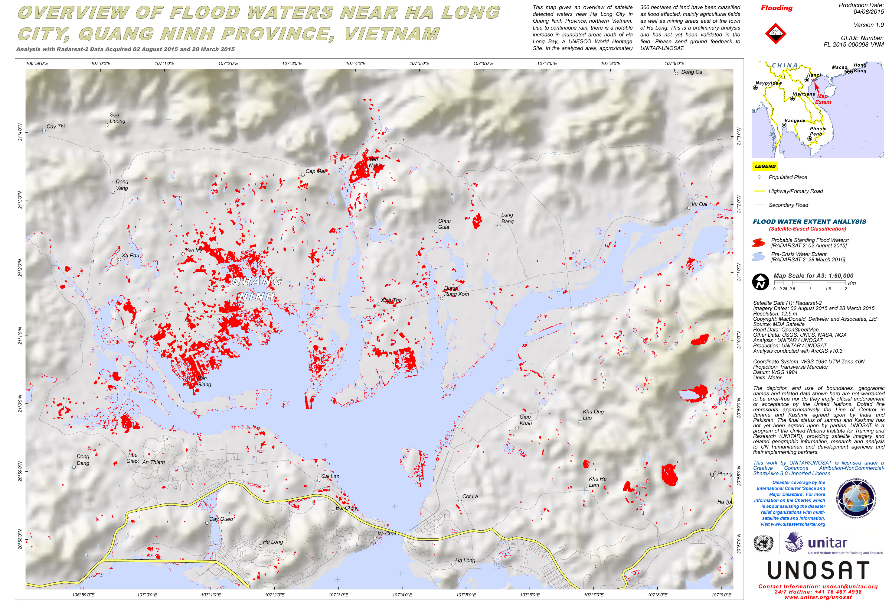
Overview of flood waters near Ha Long City, Quang Ninh Province, Vietnam
版权: RADARSAT-2 Data and Products © MacDonald, Dettwiler and Associates Ltd. (2015) - All Rights Reserved. RADARSAT is an official trademark of the Canadian Space Agency.
Map produced by UNITAR/UNOSAT
Information about the Product
已获得: Pre-disaster: 28/03/2015
Post-disaster: 02/08/2015
源: RADARSAT-2

Overview of flood waters near Hai Phong City, Vietnam
版权: JAXA 2015
Map produced by UNITAR/UNOSAT
Information about the Product
已获得: Pre-disaster: 19/06/2015
Post-disaster: 31/07/2015
源: ALOS-2 / PALSAR-2
 返回完整的响应档案

