 English
 Spanish
 French
 Chinese
 Russian
 Portuguese
 Latest Activation
Charter activations
Flood in Vietnam
Torrential rain in Vietnam has flooded the northern area of the country, leaving at least 17 dead and inundating thousands of homes.
The rain, which started on 26 July, is reportedly the heaviest the province has experienced in forty years.
Particularly affected is the Quang Ninh Province on Vietnam's north coast, with cities including Halong, Cam Pha, Uong Bi, Dong Trieu, Van Don and Hoanh Bo all experiencing flooding.
In some areas the flood waters have reached 2 metres in height, prompting rescue efforts to evacuate hundreds of residents to safe locations. It is estimated that more than 3000 homes have been affected by the floods.
The flood waters have made access to some locations difficult, as many roads have been inundated and the heavy rain has caused landslides in the mountainous areas of the province. These landslides damaged dozens of homes.
Weather forecasts currently estimate that the rain will continue into the first week of August, potentially causing further flooding and landslides.
| Tipo de evento: | Flood |
| Local do evento: | Vietnam |
| Data da Ativação da Carta: | 30 July 2015 |
| Tempo de Ativação da Carta: | 16:00:00 |
| Zona de Tempo da Ativação da Carta: | UTC+02:00 |
| Requisitante da Carta: | UNITAR/UNOSAT on behalf of UN ESCAP |
| Gerenciamento de projeto: | UNITAR/UNOSAT |
Products

Overview of flood waters in Hai Phong Province, Vietnam
Direitos autorais: Landsat 7 data and products © USGS (2015) - All rights reserved
TerraSAR-X © German Aerospace Center (DLR), 2015 Airbus Defence and Space / Infoterra GmbH
Map produced by UNITAR/UNOSAT
Information about the Product
Adquirida: Landsat 7: 05/10/2009
TerraSAR-X: 02/08/2015
Fonte: Landsat 7 / TerraSAR-X

Overview of flood waters along northern coast, Quang Ninh Province, Vietnam
Direitos autorais: RADARSAT-2 Data and Products © MacDonald, Dettwiler and Associates Ltd. (2015) - All Rights Reserved. RADARSAT is an official trademark of the Canadian Space Agency.
Map produced by UNITAR/UNOSAT
Information about the Product
Adquirida: Pre-disaster: 28/03/2015
Post-disaster: 02/08/2015
Fonte: RADARSAT-2
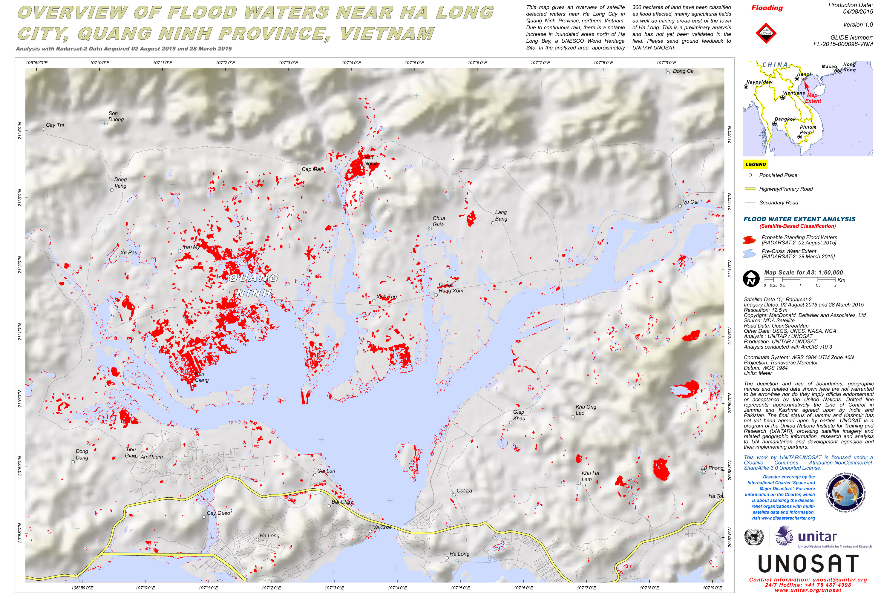
Overview of flood waters near Ha Long City, Quang Ninh Province, Vietnam
Direitos autorais: RADARSAT-2 Data and Products © MacDonald, Dettwiler and Associates Ltd. (2015) - All Rights Reserved. RADARSAT is an official trademark of the Canadian Space Agency.
Map produced by UNITAR/UNOSAT
Information about the Product
Adquirida: Pre-disaster: 28/03/2015
Post-disaster: 02/08/2015
Fonte: RADARSAT-2

Overview of flood waters near Hai Phong City, Vietnam
Direitos autorais: JAXA 2015
Map produced by UNITAR/UNOSAT
Information about the Product
Adquirida: Pre-disaster: 19/06/2015
Post-disaster: 31/07/2015
Fonte: ALOS-2 / PALSAR-2
 Voltar ao arquivo completo da Ativação

