Charter activations
Flood in Sri Lanka
Days of heavy rain have caused widespread flooding in Sri Lanka, leaving 37 dead and forcing hundreds of thousands of people to evacuate.
The torrential rain is the result of a tropical cyclone over the southern part of the Bay of Bengal and the rain is forecast to continue for several more days. The city of Kandy saw 69mm of rain and Galle had 71mm of rain in the 24 hours up to 0600 GMT on 15 May. Meanwhile Colombo recorded 128mm. Pottuui was even wetter with 144mm in the same period of time. The town of Killinochchi received 372mm of rain in just a 24 hour period on 18 May, a quarter of the area's normal annual rainfall.
The army and navy have been deployed to assist rescue operations and to help evacuate residents in low-lying areas or on slopes, at risk of flooding and landslides.
Some areas have been cut off by inundated roads, debris and fallen power lines. Motorists have been warned to be cautious of further landslides and residents in down-stream areas have been asked to stay aware of the water levels of canals and rivers nearby. The Kelani River has been overflowing, and residents nearby have been evacuated.
Over 200,000 people have sought refuge in welfare centres and it is estimated that as many as 300,000 people may be affected by the disaster. Hundreds of homes have been damaged by the floods and some villages have been entirely inundated by the flood waters or buried by landslides.
| Type of Event: | Flood |
| Location of Event: | Sri Lanka |
| Date of Charter Activation: | 17 May 2016 |
| Time of Charter Activation: | 08:36:57 |
| Time zone of Charter Activation: | UTC+02:00 |
| Charter Requestor: | ADRC on behalf of IWMI - DMC |
| Project Management: | Asian Institute of Technology (AIT) |
Products

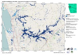
Flood in Colombo and Gampaha along the Kelani River, Sri Lanka
Copyright: RADARSAT-2 Data and Products © MacDonald, Dettwiler and Associates Ltd. (2016) - All Rights Reserved. RADARSAT is an official trademark of the Canadian Space Agency.
Map produced by Geoinformatics Center, AIT
Information about the Product
Acquired: Pre-disaster: 30/09/2015
Post-disaster: 24/05/2016
Source: RADARSAT-2

Monitoring and assessment of flood situation on 21 May
Download the flood monitoring bulletin
Copyright: RISAT-1 data and products © ISRO (2016) - All rights reserved
TerraSAR-X © DLR e. V. 2016, Distribution: Airbus DS Geo GmbH
Bulletin produced by International Water Management Institute
Information about the Product
Acquired: RISAT-1: 20/05/2016
TerraSAR-X: 21/05/2016
Source: RISAT-1 / TerraSAR-X

Monitoring and assessment of flood situation on 20 May using satellite data and Unmanned Aerial Vehicles
Download the flood monitoring bulletin
Copyright: DLR e. V. 2016, Distribution: Airbus DS Geo GmbH
Bulletin produced by International Water Management Institute
Information about the Product
Acquired: Pre-disaster: 05/12/2008
Post-disaster: 21/05/2016
Source: TerraSAR-X

Flood extent for Colombo and Gampaha, Sri Lanka
Copyright: RADARSAT-2 Data and Products © MacDonald, Dettwiler and Associates Ltd. (2016) - All Rights Reserved. RADARSAT is an official trademark of the Canadian Space Agency.
Map produced by International Water Management Institute
Information about the Product
Acquired: 21/05/2016
Source: RADARSAT-2
 Back to the full activation archive

 English
 Spanish
 French
 Chinese
 Russian
 Portuguese


