 English
 Spanish
 French
 Chinese
 Russian
 Portuguese
 Последняя Активация
Charter activations
Floods in southern Africa
Heavy flooding affected a number of southern Africa countries including Mozambique, Zimbabwe and Zambia. Media provisionally reported that almost 7,000 households have reached resettlement centres and more than 30,000 hectares of crops have been lost.
| Тип события: | Floods |
| Место события: | Zambia, Zimbabwe, Mozambique |
| Date of Charter Activation: | 10/01/2008 17:44 UTC |
| Запрос на активацию поступил от: | USGS |
| Менеждер проекта от: | Regional Centre for Mapping of Resources for Development |
Products
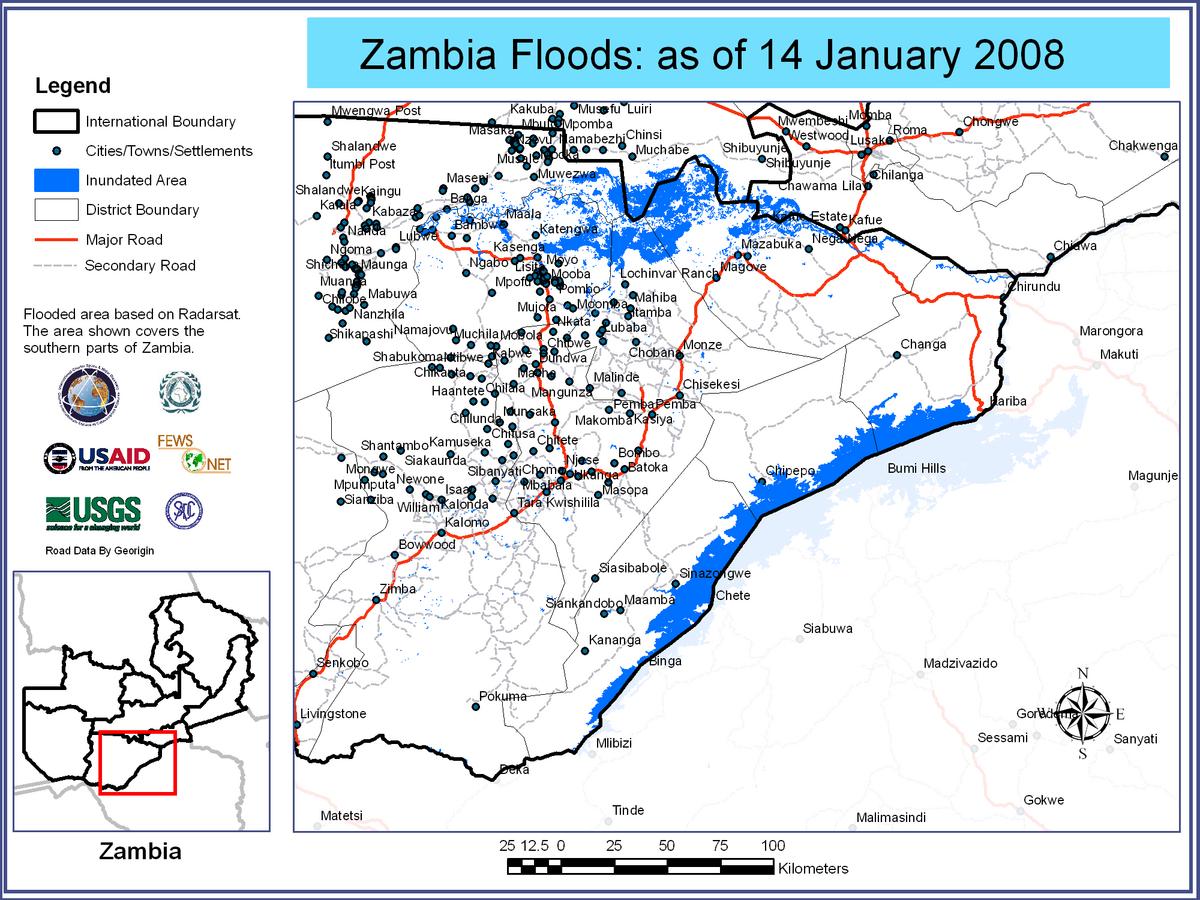
Flooded Areas of Zambia, 14/01/2008
Авторские права: CSA 2008 Image processing, map created 03/02/2008 by USGS/SADC (South African Development Community).
Information about the Product
Получено: 14/01/2008 Satellite-detected flooded areas over Zambia, southern areas.
Источник: RADARSAT-1 , 12.5m/pixel resolution.
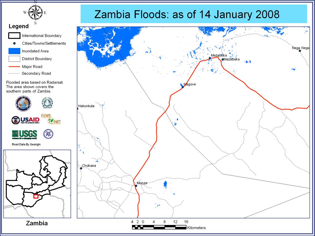
Flooded Areas of Zambia, 14/01/2008
Авторские права: CSA 2008 Image processing, map created 03/02/2008 by USGS/SADC (South African Development Community).
Information about the Product
Получено: 14/01/2008 Satellite-detected flooded areas over Zambia, areas around Magove.
Источник: RADARSAT-1 , 12.5m/pixel resolution.
Flooded Areas of Zambia, 14/01/2008
Авторские права: CSA 2008 Image processing, map created 03/02/2008 by USGS/SADC (South African Development Community).
Information about the Product
Получено: 14/01/2008 Satellite-detected flooded areas over Zambia, areas around Maala.
Источник: RADARSAT-1 , 12.5m/pixel resolution.
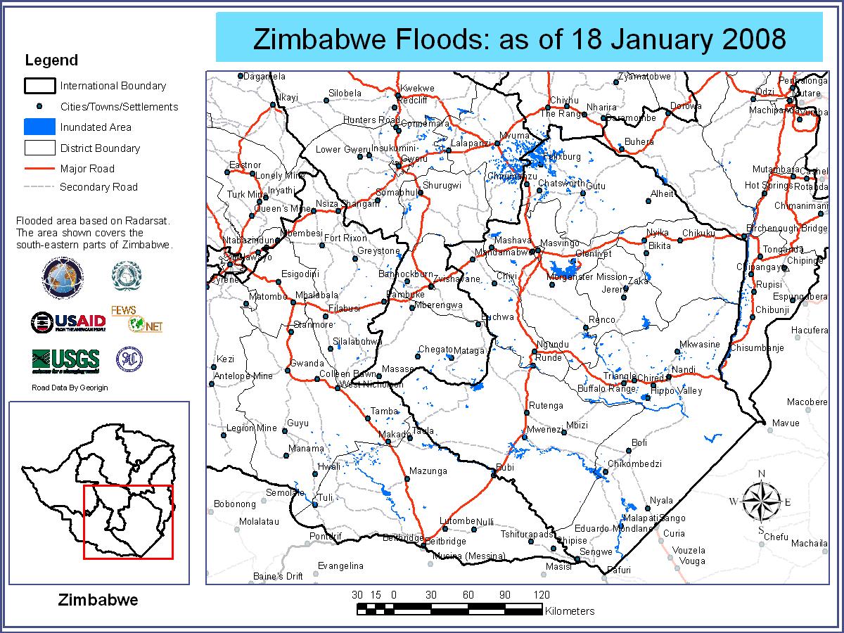
Flooded Areas of Zimbabwe, 18/01/2008
Авторские права: CSA 2008 Image processing, map created 03/02/2008 by USGS/SADC (South African Development Community).
Information about the Product
Получено: 18/01/2008 Satellite-detected flooded areas over Zimbabwe, southeastern areas.
Источник: RADARSAT-1 , 12.5m/pixel resolution.
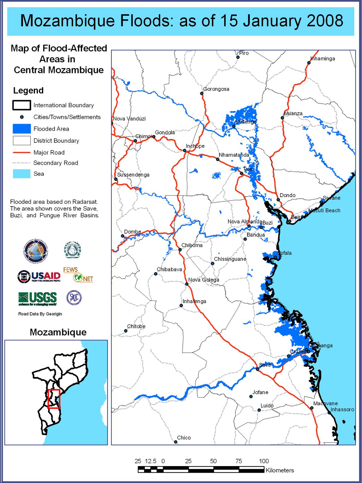
Flooded Areas of Mozambique, 15/01/2008
Авторские права: CSA 2008 Image processing, map created 03/02/2008 by USGS/SADC (South African Development Community).
Information about the Product
Получено: 15/01/2008 Satellite-detected flooded areas over Mozambique, central areas.
Источник: RADARSAT-1 , 12.5m/pixel resolution.
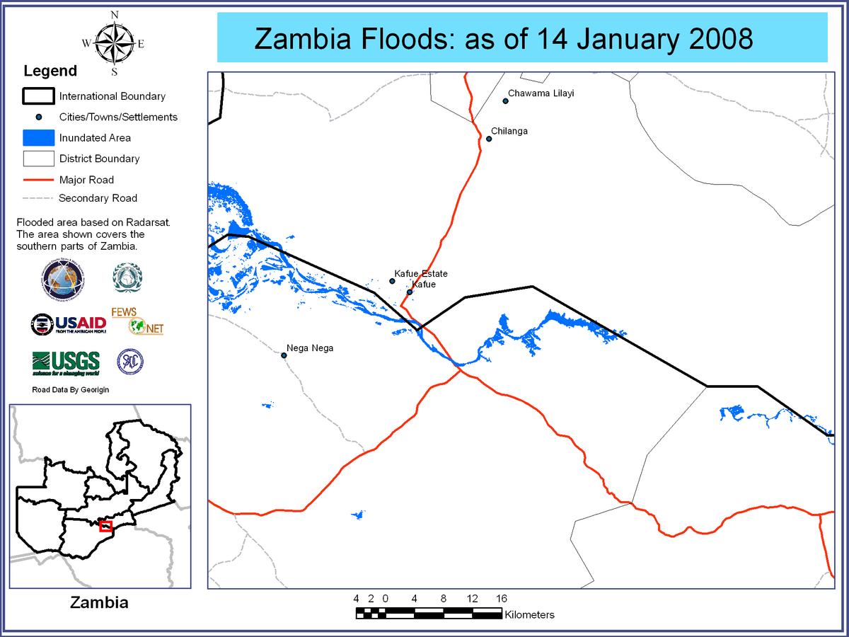
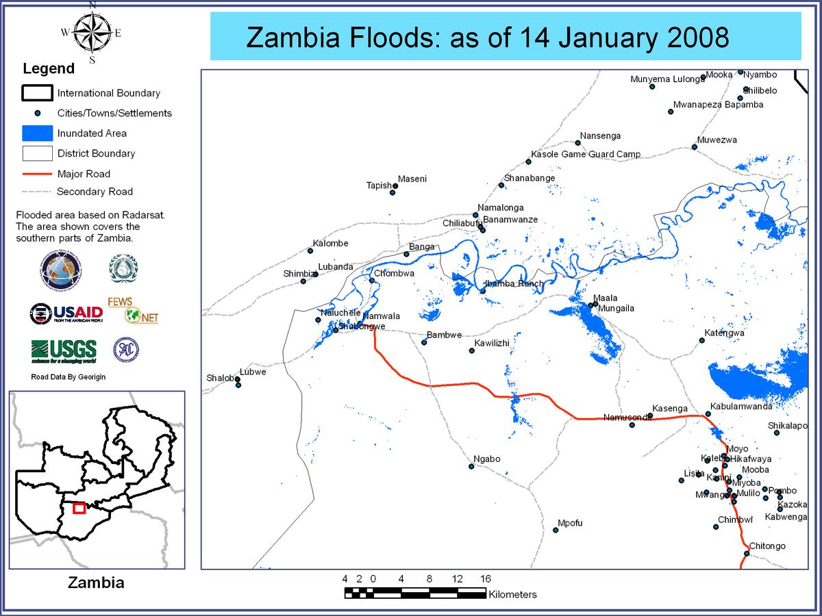
Flooded Areas of Zambia, 14/01/2008
Авторские права: CSA 2008 Image processing, map created 03/02/2008 by USGS/SADC (South African Development Community).
Information about the Product
Получено: 14/01/2008 Satellite-detected flooded areas over Zambia, areas around Kafue.
Источник: RADARSAT-1 , 12.5m/pixel resolution.
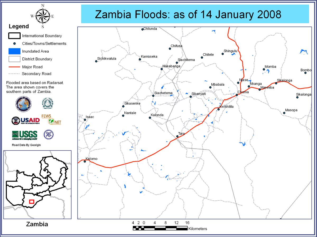
Flooded Areas of Zambia, 14/01/2008
Авторские права: CSA 2008 Image processing, map created 03/02/2008 by USGS/SADC (South African Development Community).
Information about the Product
Получено: 14/01/2008 Satellite-detected flooded areas over Zambia, areas around Choma.
Источник: RADARSAT-1 , 12.5m/pixel resolution.
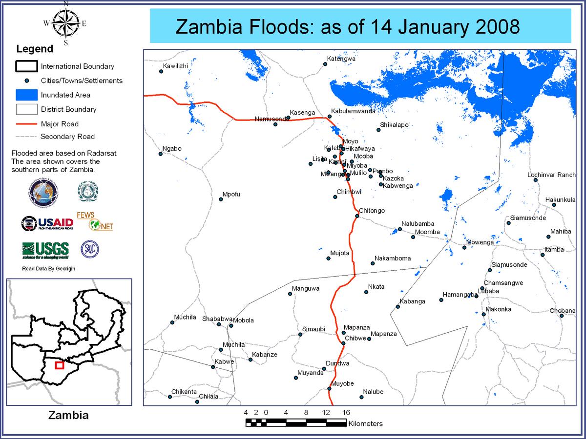
Flooded Areas of Zambia, 14/01/2008
Авторские права: CSA 2008 Image processing, map created 03/02/2008 by USGS/SADC (South African Development Community).
Information about the Product
Получено: 14/01/2008 Satellite-detected flooded areas over Zambia, areas around Chitongo.
Источник: RADARSAT-1 , 12.5m/pixel resolution.

Flood Waters over Southern Provinces of Zambia, 10/01/2008
Авторские права: ESA 2008, 2007 Image processing, map created 25/01/2008 by USGS/SADC (South African Development Community).
Information about the Product
Получено: 10/01/2008 and 25/01/2007 Satellite-detected flood waters over southern Zambia (in red). Flood water analysis using multi-temporal ASAR scenes from 10/01/2008 and 25/01/2007. Preliminary analysis not yet validated in the field.
Источник: Envisat ASAR WSM, 150m/pixel resolution.
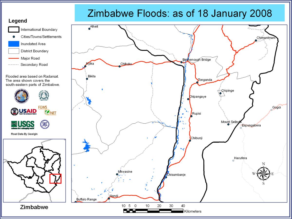
Flooded Areas of Zimbabwe, 18/01/2008
Авторские права: CSA 2008 Image processing, map created 03/02/2008 by USGS/SADC (South African Development Community).
Information about the Product
Получено: 18/01/2008 Satellite-detected flooded areas over Zimbabwe, areas around Tonganda.
Источник: RADARSAT-1 , 12.5m/pixel resolution.

Flooded Areas of Zimbabwe, 18/01/2008
Авторские права: CSA 2008 Image processing, map created 03/02/2008 by USGS/SADC (South African Development Community).
Information about the Product
Получено: 18/01/2008 Satellite-detected flooded areas over Zimbabwe, areas around Nandi.
Источник: RADARSAT-1 , 12.5m/pixel resolution.
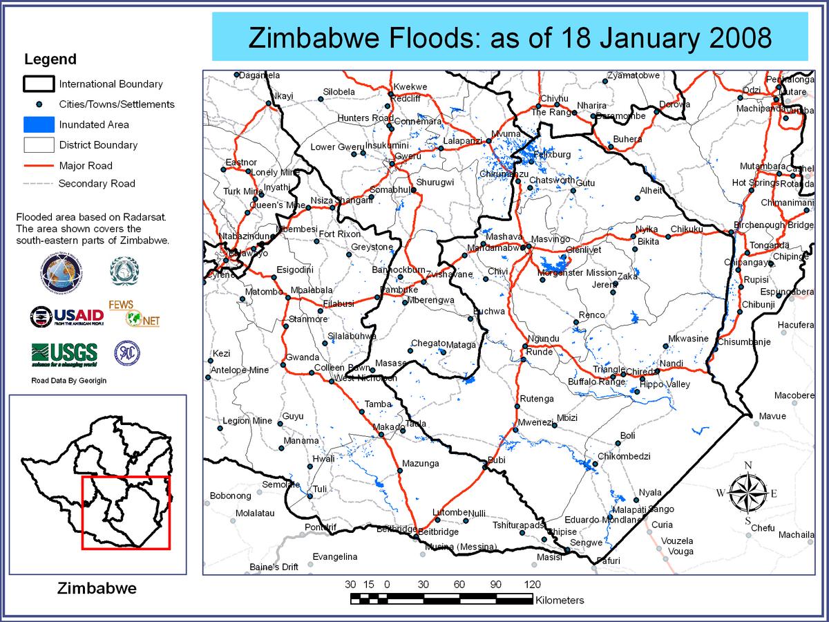
Flooded Areas of Zimbabwe, 18/01/2008
Авторские права: CSA 2008 Image processing, map created 03/02/2008 by USGS/SADC (South African Development Community).
Information about the Product
Получено: 18/01/2008 Satellite-detected flooded areas over Zimbabwe, areas around Masvingo.
Источник: RADARSAT-1 , 12.5m/pixel resolution.
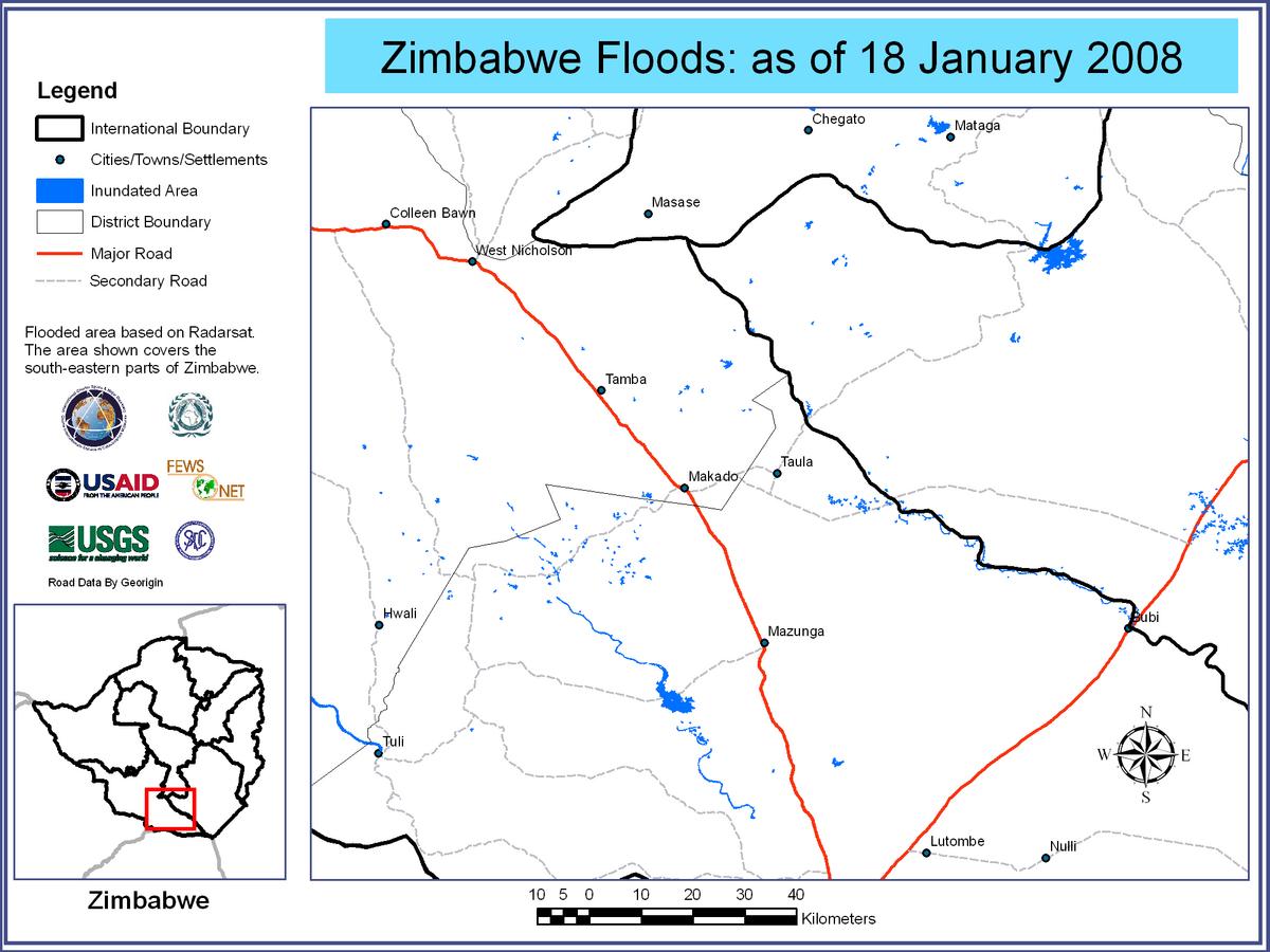
Flooded Areas of Zimbabwe, 18/01/2008
Авторские права: CSA 2008 Image processing, map created 03/02/2008 by USGS/SADC (South African Development Community).
Information about the Product
Получено: 18/01/2008 Satellite-detected flooded areas over Zimbabwe, areas around Makado.
Источник: RADARSAT-1 , 12.5m/pixel resolution.
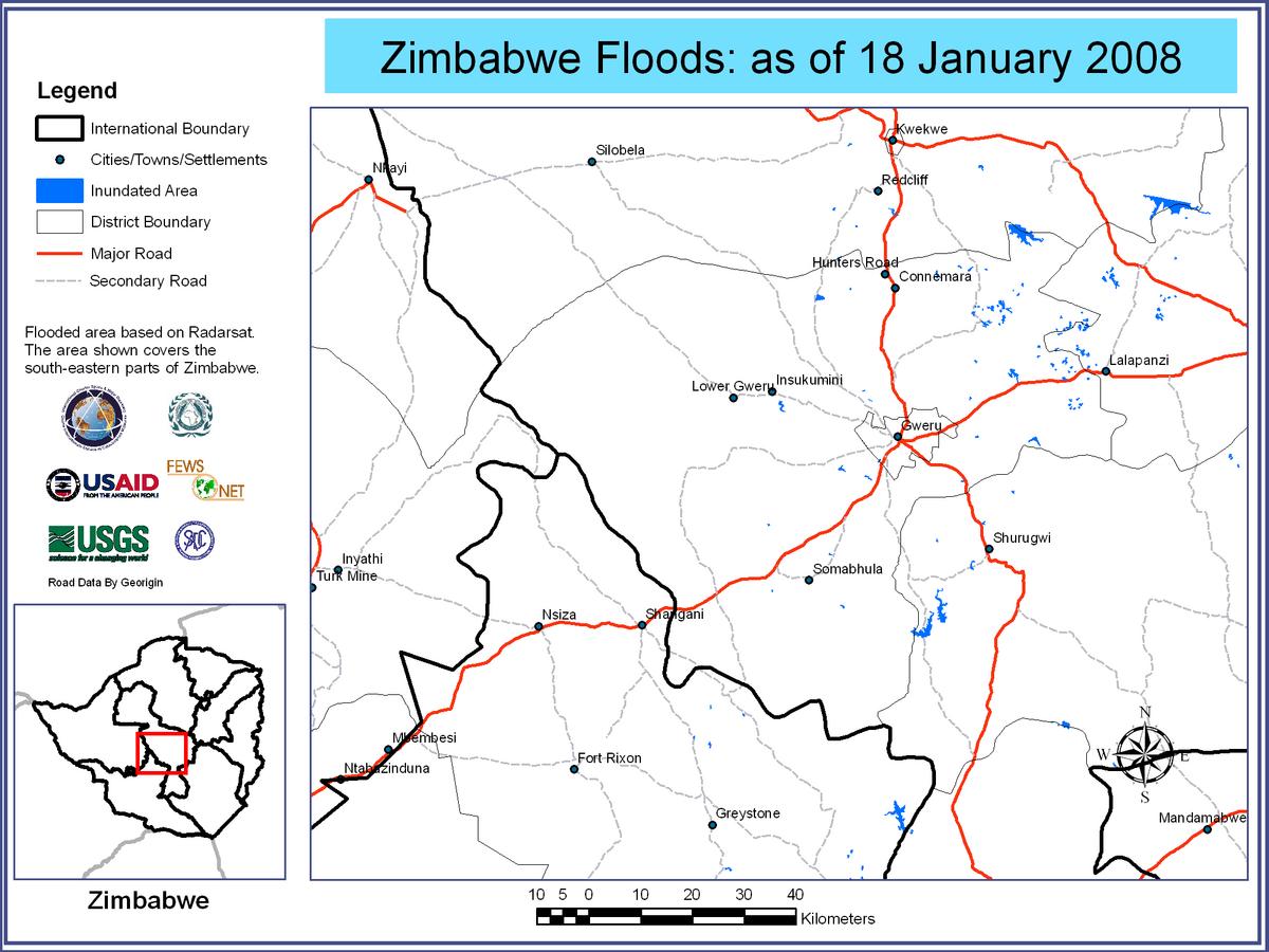
Flooded Areas of Zimbabwe, 18/01/2008
Авторские права: CSA 2008 Image processing, map created 03/02/2008 by USGS/SADC (South African Development Community).
Information about the Product
Получено: 18/01/2008 Satellite-detected flooded areas over Zimbabwe, areas around Gweru.
Источник: RADARSAT-1 , 12.5m/pixel resolution.

Flooded Areas of Zimbabwe, 18/01/2008
Авторские права: CSA 2008 Image processing, map created 03/02/2008 by USGS/SADC (South African Development Community).
Information about the Product
Получено: 18/01/2008 Satellite-detected flooded areas over Zimbabwe, areas around Chikombedzi.
Источник: RADARSAT-1 , 12.5m/pixel resolution.
 Вернуться к полному архиву активаций

