Flooding in Libya
Charter activations
Flooding in Libya
Severe flooding affected the coastal city of Zliten, in Libya, as well as the town of Bir Al Ghanem.
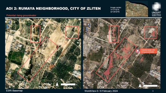
The flooding was the result of rising ground water levels in this area. The phenomenon has been ongoing for several years, but increased with water levels reaching as high as 1.5 m in some locations.
Low-lying houses were flooded and around 70-80 families were evacuated.
The government declared a state of emergency to respond to the crisis, and international experts were called on to investigate the cause.
Related News and Resources
| Tipo de evento: | Flood |
| Local do evento: | Libya |
| Data da Ativação da Carta: | 2024-02-06 |
| Tempo de Ativação da Carta: | 21:39 |
| Zona de Tempo da Ativação da Carta: | UTC+01:00 |
| Requisitante da Carta: | UNITAR on behalf of UNOCHA |
| ID da Ativação: | 860 |
| Gerenciamento de projeto: | Samir Belabbes (UNITAR) |
Products

Preliminary satellite-derived flood impact assessment, City of Zliten, Libya
Download the Full Report
Direitos autorais: WorldView-2 © (2024) DigitalGlobe, Inc., Longmont CO USA 80503.
DigitalGlobe and the DigitalGlobe logos are trademarks of DigitalGlobe, Inc. The use and/or dissemination of this data and/or of any product in any way derived there from are restricted. Unauthorized use and/or dissemination is prohibited
Includes Pleiades material © CNES (2024), Distribution Airbus DS.
Report produced by UNOSAT/UNITAR.
Information about the Product
Adquirida: WorldView-2: 03/03/2024
Pleiades: 09/02/2023
Fonte: WorldView-2 and Pleiades
Categoria: Dossier

Satellite detected water in the Rumaya Neighborhood, City of Zliten, Libya
Direitos autorais: WorldView-3 © (2024) DigitalGlobe, Inc., Longmont CO USA 80503.
DigitalGlobe and the DigitalGlobe logos are trademarks of DigitalGlobe, Inc. The use and/or dissemination of this data and/or of any product in any way derived there from are restricted. Unauthorized use and/or dissemination is prohibited.
Includes Pleiades Neo material © Airbus DS (2024)
Jilin-1 © Chang Guang Satellite Technology Co., Ltd (2024)
Map produced by UNOSAT.
Information about the Product
Adquirida: WorldView-3: 08/02/2024
Pleiades Neo: 09/02/2024
Jilin-1: 08/02/2024
Fonte: WorldView-3, Pleiades Neo and Jilin-1
Categoria: Grading Map

Preliminary Satellite-Derived Flood Impact Assessment in the City of Zliten, Libya
Download the Full Report
Direitos autorais: WorldView-3 © (2024) DigitalGlobe, Inc., Longmont CO USA 80503.
DigitalGlobe and the DigitalGlobe logos are trademarks of DigitalGlobe, Inc. The use and/or dissemination of this data and/or of any product in any way derived there from are restricted. Unauthorized use and/or dissemination is prohibited.
Jilin-1 © Chang Guang Satellite Technology Co., Ltd (2024).
Report produced by UNOSAT/UNITAR.
Information about the Product
Adquirida: Jilin-1: 27/01/2024
WorldView-3: 08/02/2024
Fonte: WorldView-3 and Jilin-1
Categoria: Delineation Map
 Voltar ao arquivo completo da Ativação

 English
 Spanish
 French
 Chinese
 Russian
 Portuguese

