 English
 Spanish
 French
 Chinese
 Russian
 Portuguese
 Latest Activation
Charter activations
Cyclone Gombe in Mozambique
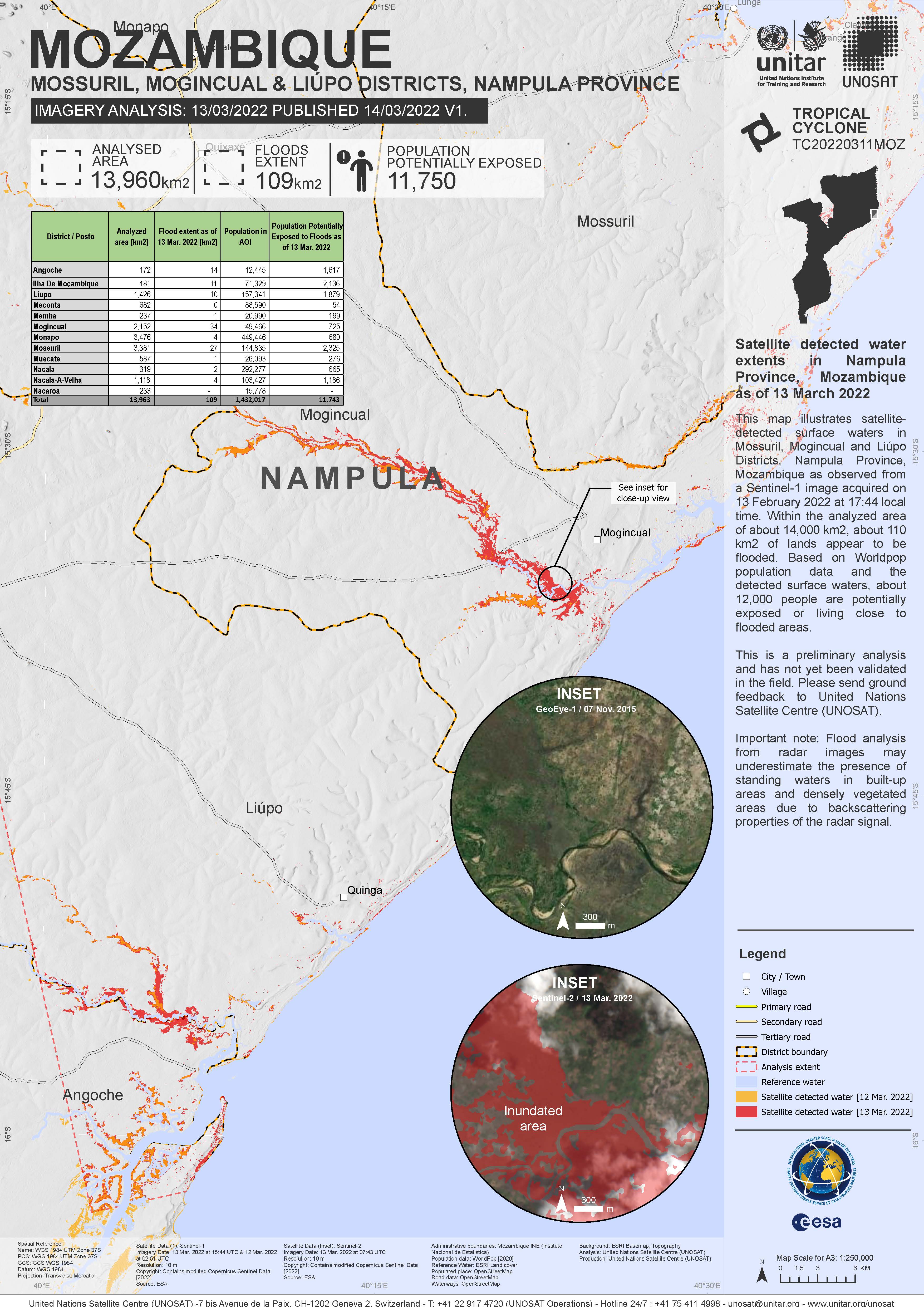
According to the National Institute for Disaster Risk Reduction of Mozambique (INGD), Cyclone Gombe made landfall as a Category 3 Tropical Cyclone on 11 March on the coast of Mozambique between Mossuril and Mogincual districts (Nampula Province).
Preliminary impacts reported by INGD indicate that many houses and power lines were destroyed or damaged; twelve people have been reported killed, several have been injured, and overall more than thirty thousand people have been affected. Over one hundred schools were reported damaged or destroyed, one bridge collapsed, and several roads were affected.
| Tipo de evento: | Ocean Storm - Cyclone |
| Local do evento: | Mozambique |
| Data da Ativação da Carta: | 2022-03-13 |
| Tempo de Ativação da Carta: | 17:08 |
| Zona de Tempo da Ativação da Carta: | UTC+01:00 |
| Requisitante da Carta: | UNOOSA/UN-SPIDER on behalf of National Institute for Disaster Risk Reduction of Mozambique (INGD) |
| ID da Ativação: | 753 |
| Gerenciamento de projeto: | UNITAR/UNOSAT |
Products
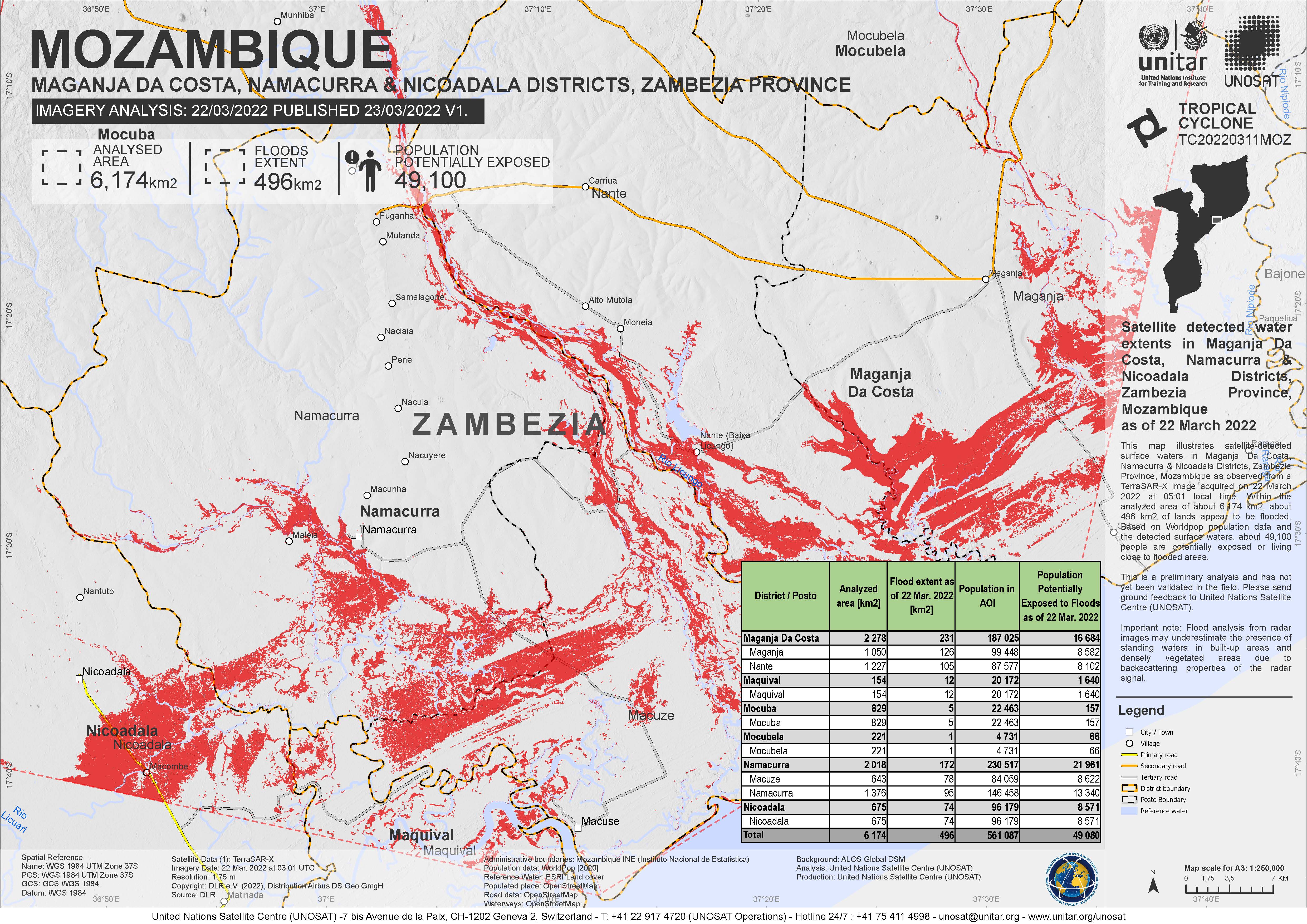
Satellite detected water extents in Maganja Da Costa, Namacurra & Nicoadala Districts, Zambezia Province, Mozambique
Direitos autorais: © DLR e.V. (2022), Distribution Airbus DS Geo GmbH
Map produced by UNITAR / UNOSAT
Information about the Product
Adquirida: 22/03/2022
Fonte: TerraSAR-X
Categoria: Delineation Map


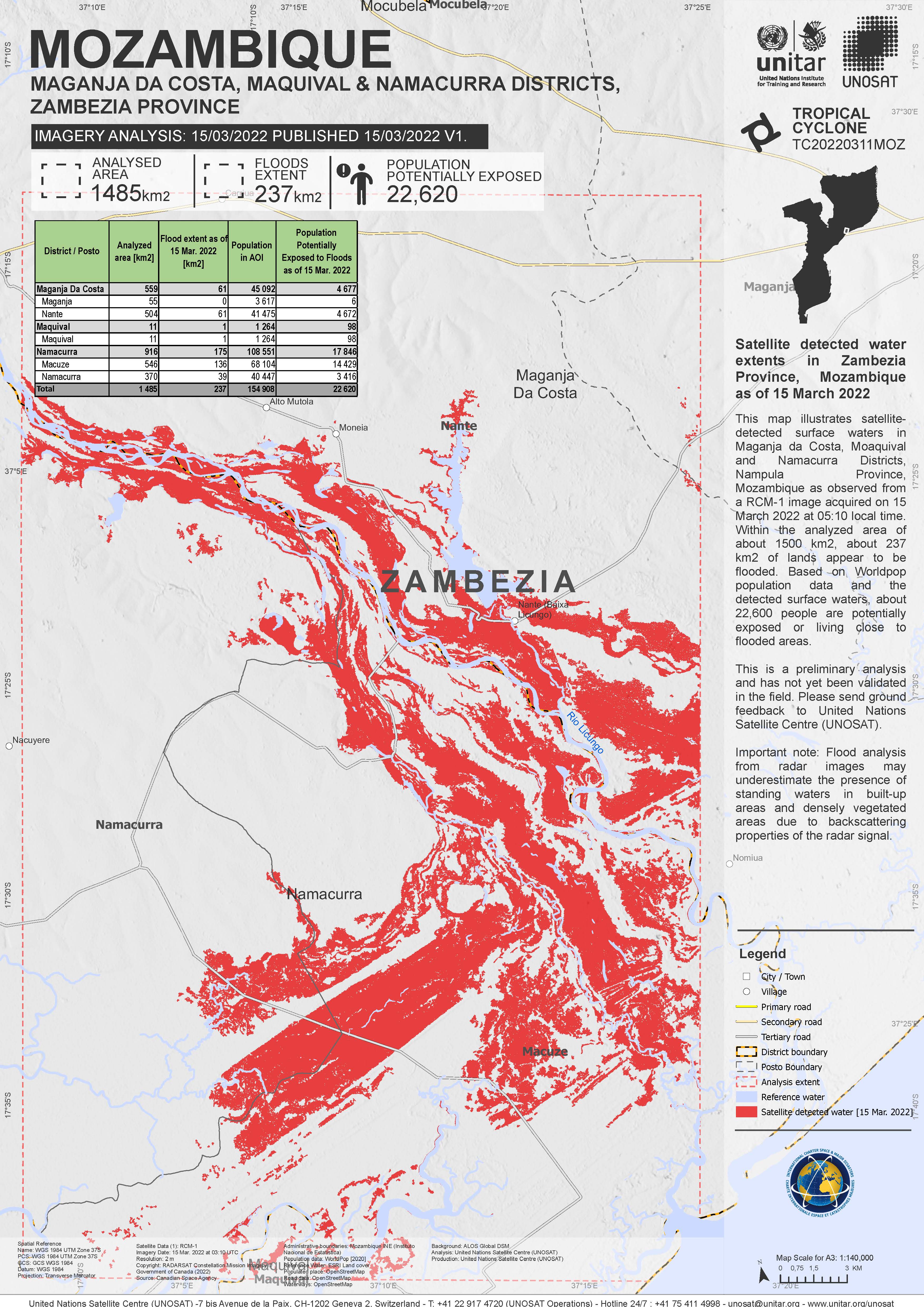
Satellite detected water extents in Maganja Da Costa & Namacurra Districts, Zambezia Province, Mozambique
Direitos autorais: © DLR e.V. (2022), Distribution Airbus DS Geo GmbH
Map produced by UNOSAT / UNITAR
Information about the Product
Adquirida: 16/03/2022
Fonte: TerraSAR-X
Categoria: Delineation Map

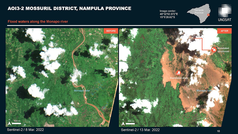
Preliminary satellite-derived flood assessment, Mogincual District, Nampula Province, Mozambique
Download full report
Direitos autorais: Contains modified Copernicus Sentinel data (2022)
Map produced by UNITAR / UNOSAT
Information about the Product
Adquirida: 13/03/2022, 15/03/2022
Fonte: Sentinel-2
Categoria: Delineation Map
Satellite detected water extent in Zambezia Province, Mozambique
Direitos autorais: RADARSAT Constellation Mission Imagery © Government of Canada (2022) - RADARSAT is an official mark of the Canadian Space Agency
Map produced by UNITAR / UNOSAT
Information about the Product
Adquirida: 15/03/2022
Fonte: RCM
Categoria: Reference Map
Preliminary flood assessment of Nampula Province, Mozambique
Download the full report
Direitos autorais: Contains modified Copernicus Sentinel data (2022)
Report produced by UNITAR/UNOSAT
Information about the Product
Adquirida: 13/03/2022
Fonte: Sentinel-2
Categoria: Dossier
 Voltar ao arquivo completo da Ativação

