 English
 Spanish
 French
 Chinese
 Russian
 Portuguese
 Latest Activation
Charter activations
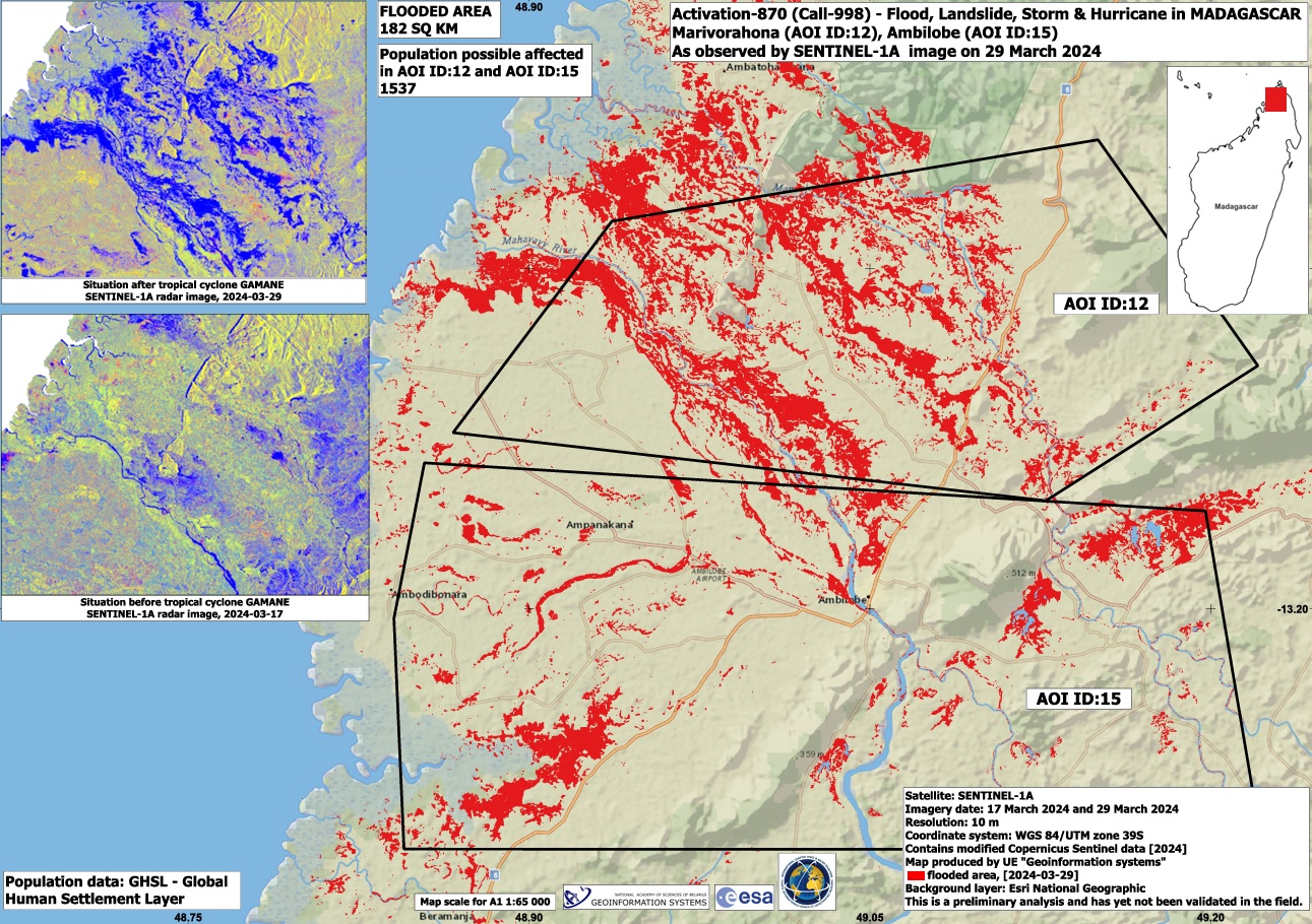
Cyclone Gamane in Madagascar
Cyclone Gamane made landfall in Madagascar on 27 March, leaving 18 dead and affecting thousands of people.
The storm was originally forecast to pass by the northern coast of the country, but unexpectedly changed course on 27 March, crossing over Vohémar district in the early hours of the day and continuing across the north-eastern districts of the island. The slow-moving storm dissipated in the afternoon on 28 March.
Gamane brought heavy rain to the northern areas of Madagascar, and strong winds, causing floods and damage to infrastructure. It is estimated that more than 20,000 people were forced from their homes by the storm.
Related News and Resources
| Tipo de evento: | Storm - Cyclone, Floods |
| Local do evento: | Madagascar |
| Data da Ativação da Carta: | 2024-03-29 |
| Tempo de Ativação da Carta: | 13:38 |
| Zona de Tempo da Ativação da Carta: | UTC+03:00 |
| Requisitante da Carta: | Bureau National de Gestion des Risques et des Catastrophes (BNGRC) |
| ID da Ativação: | 870 |
| Gerenciamento de projeto: | Battiston Stephanie (SERTIT) |
| act-value-adders: | Teodoro Hunger (UNITAR/UNOSAT) Konstantin Homenkov (Geoniformation systems) Dalia Laoubi (CSA) NOAA VA (NOAA) BUREAU NATIONAL DE GESTION DES RISQUES ET DES CATASTROPHES (BNGRC) INPE Camila Gonçalves dos Santos (UFRRJ) |
Products

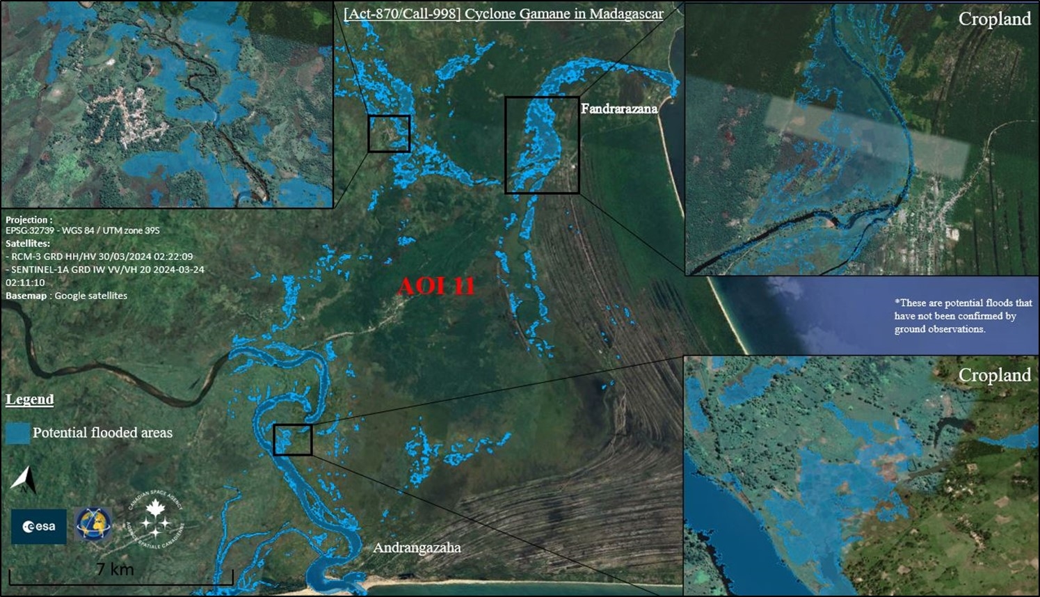
Areas affected by floods in Madagascar
Direitos autorais: RADARSAT Constellation Mission Imagery © Government of Canada (2024) - RADARSAT is an official mark of the Canadian Space Agency
Contains modified Copernicus Sentinel data (2024)
Map produced by The Canadian Space Agency
Information about the Product
Adquirida: Sentinel-1: 24/03/2024
RCM-3: 30/03/2024
Fonte: RCM and Sentinel
Categoria: Delineation Map


Preliminary satellite-derived flood assessment, Ambanja District, Diana Region, Madagascar
Download the full report
Direitos autorais: © (2024) DigitalGlobe, Inc., Longmont CO USA 80503. DigitalGlobe and the DigitalGlobe logos are trademarks of DigitalGlobe, Inc. The use and/or dissemination of this data and/or of any product in any way derived there from are restricted. Unauthorized use and/or dissemination is prohibited.
Report produced by UNITAR / UNOSAT
Information about the Product
Adquirida: 04/04/2024
Fonte: WorldView-2
Categoria: Reference Map


Flood impact in Anivorano, Madagascar (AOI ID:1)
Direitos autorais: Landsat data and products © NASA/USGS (2023 & 2024) - All Rights Reserved
Map produced by Geoinformation Systems
Information about the Product
Adquirida: Landsat 8: 04/04/2024
Landsat 9: 28/05/2023
Fonte: Landsat 8 and Landsat 9
Categoria: Delineation Map


Preliminary satellite-derived flood assessment, Sava & Sofia Regions, Madagascar
Download the full report
Direitos autorais: © Planet Labs Inc. (2024)
© (2024) DigitalGlobe, Inc., Longmont CO USA 80503. DigitalGlobe and the DigitalGlobe logos are trademarks of DigitalGlobe, Inc. The use and/or dissemination of this data and/or of any product in any way derived there from are restricted. Unauthorized use and/or dissemination is prohibited
Report produced by UNITAR / UNOSAT
Information about the Product
Adquirida: PlanetScope: 31/03/2024, 01/04/2024
WorldView-3: 31/03/2024
Fonte: PlanetScope / WorldView-3
Categoria: Reference Map
 Voltar ao arquivo completo da Ativação

