 English
 Spanish
 French
 Chinese
 Russian
 Portuguese
 Dernière activation
Charter activations
Cyclone Gita in Tonga
Cyclone Gita, a Category 4 storm, hit Tonga on 12 February after causing widespread damage in the neighbouring island of Samoa. The eye of the storm passed over Tongatapu island, the most populous island group in Tonga, causing one fatalitly and injuring 33.
The National Emergency Management Office (NEMO) reported that 79% of the population had been affected, and confirmed Gita as the strongest storm to his the islands on record. Over 100 evacuation centres were prepared to house over 4500 evacuees as the Tongan government declared a state of emergency.
Gita caused extensive flooding in low lying, coastal and river areas around Savai'I and Upolu and further widesread flooding in the Vaisigano catchment area with thousands of properties being damaged.
The storm affected Tonga's power supply, with authorities confirming that Tongatapu was without power after winds exceeding 190 mph damaged infrastructure, leaving hospitals only remaining operational through generators.
By the 15 February the storm moved south-southwest away from Tonga heading towards New Caledonia.
| Type of Event: | Ocean Storm - Cyclone |
| Location of Event: | Tonga |
| Date of Charter Activation: | 2018-02-12 |
| Time of Charter Activation: | 09:28 |
| Time zone of Charter Activation: | UTC+01:00 |
| Charter Requestor: | UNITAR-UNOSAT on behalf of United Nations Office for the Coordination of Humanitarian Affairs (OCHA) | Regional Office for Asia and the Pacific (ROAP) |
| Activation ID: | 566 |
| Project Management: | UNITAR/UNOSAT |
Products
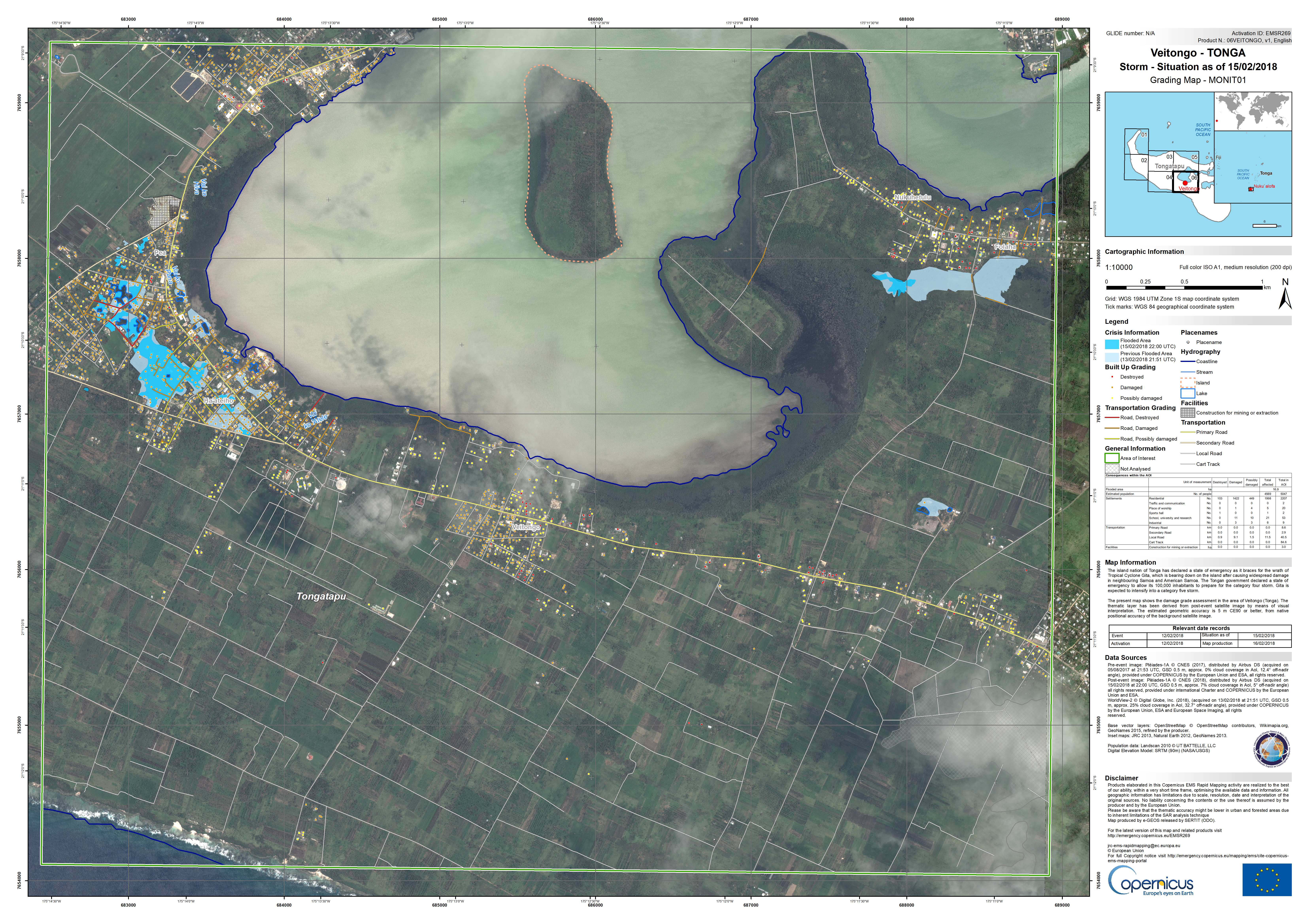
Carte de classement de Veitongo sur l'île de Tongatapu
Voir plus de Copernicus EMS
Copyright: Pleiades © CNES (2018) - Distribution: Airbus Defence and Space, tous droits réservés
WorldView-2 © DigitalGlobe Inc.
Carte produite e-GEOS
Information about the Product
Acquired: Pleiades: 05/08/2017 et 15/02/2018
WorldView-2: 13/02/2018
Source: Pleiades / WorldView-2
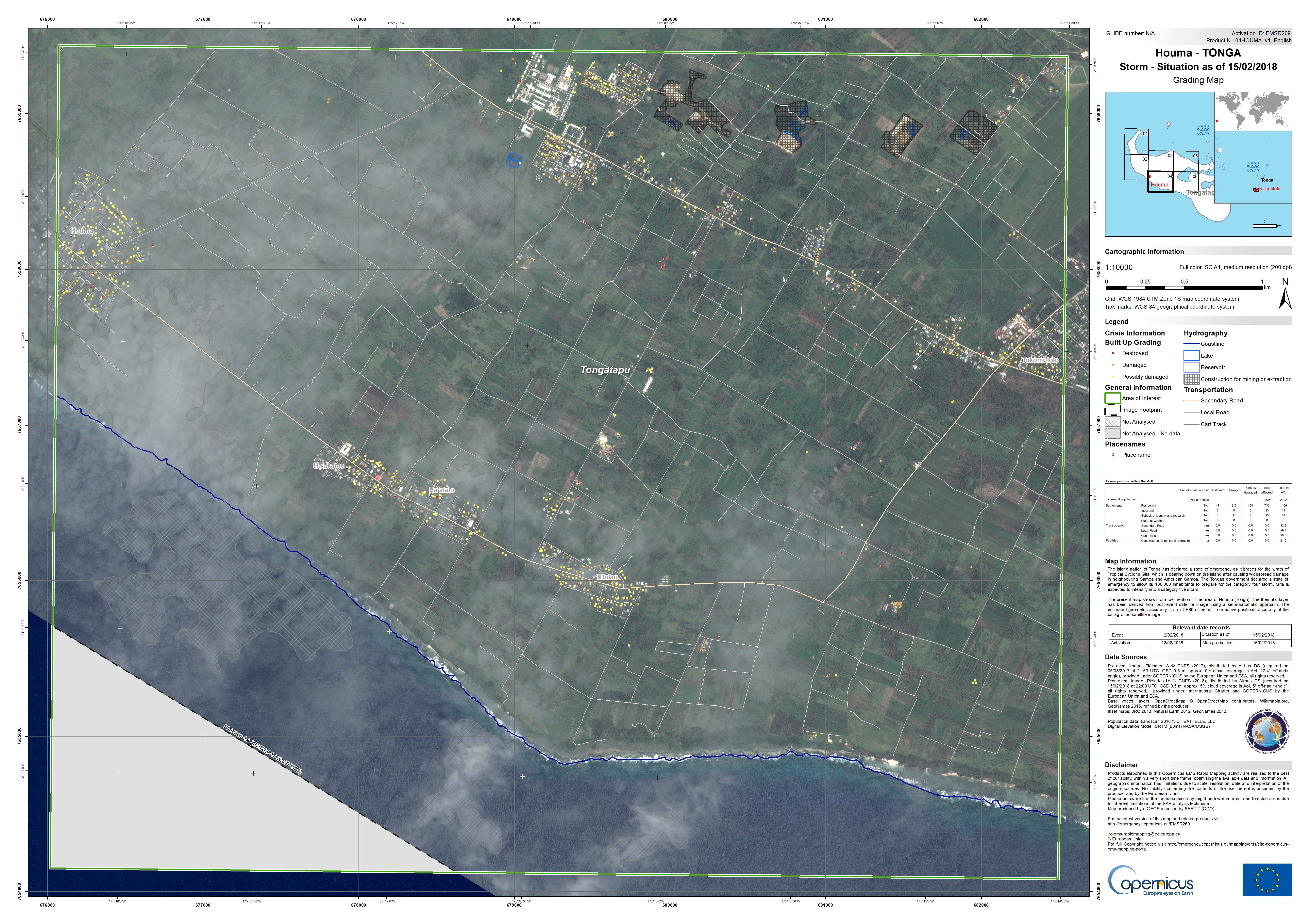
Carte de classement de Houma sur l'île de Tongatapu
Voir plus de Copernicus EMS
Copyright: Pleiades © CNES (2018) - Distribution: Airbus Defence and Space, tous droits réservés
Carte produite par e-GEOS
Information about the Product
Acquired: Pré-catastrophe: 05/08/2017
Post-catastrophe: 15/02/2018
Source: Pleiades
Gita-18: Aperçu détaillé de l'évaluation des dommages aux bâtiments détectés par satellite au 28 février 2018
Télécharger le rapport complet
Copyright: Pleiades © CNES (2018) - Distribution: Airbus Defence and Space, tous droits réservés
WorldView-2 © DigitalGlobe Inc.
WorldView-3 © DigitalGlobe Inc.
Carte produite parUNITAR/UNOSAT
Information about the Product
Acquired: Pleiades: 14/02/2018, 15/02/2018, 16/02/2018 et 21/02/2018
WorldView-3: 12/01/2018
WorldView-2: 13/02/2018
Source: Pleiades / WorldView-2 / WorldView-3
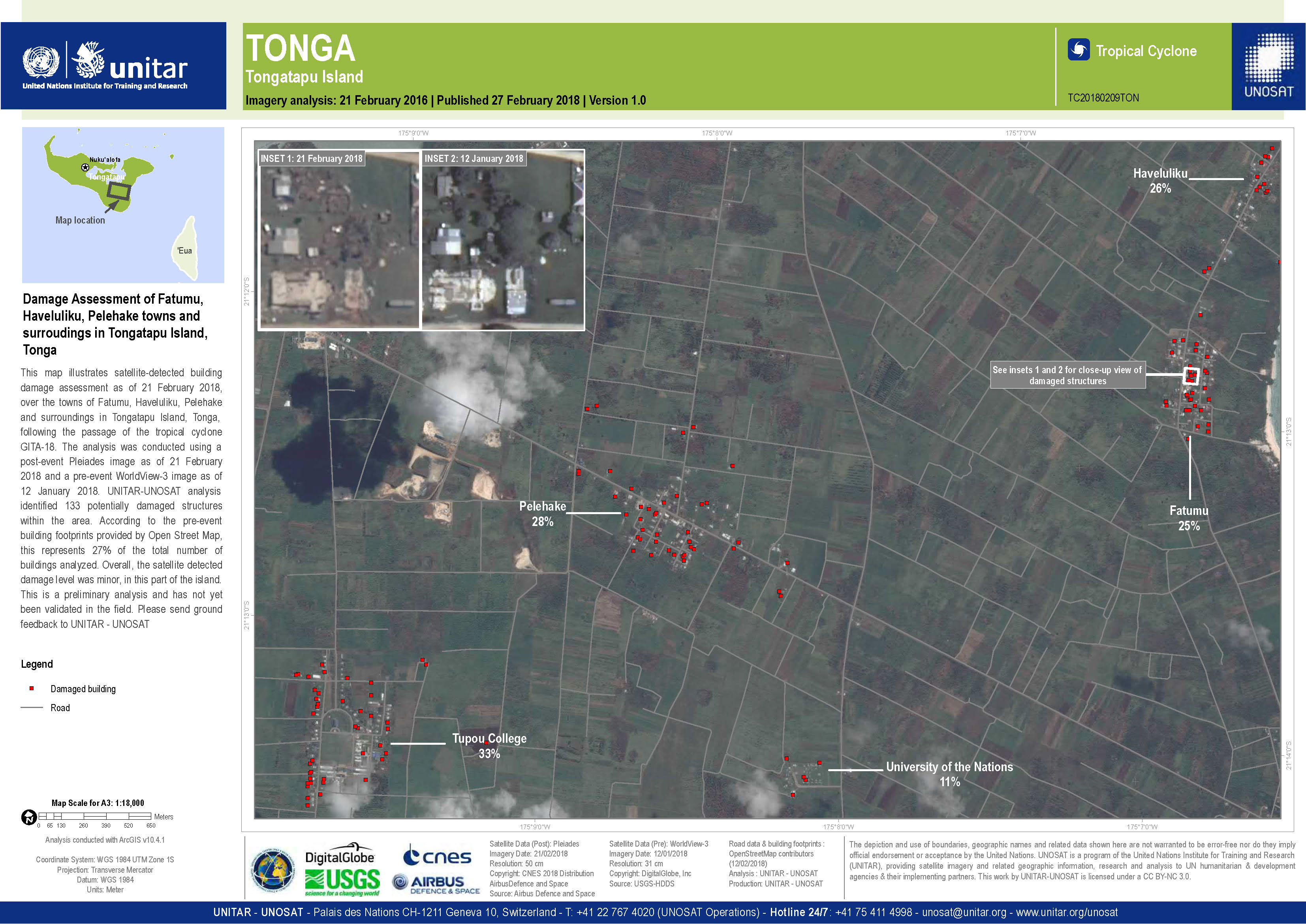
Évaluation des dommages de Fatumu, Haveluliku, Pelehake, sur l'île de Tongatapu
Copyright: Pleiades © CNES (2018) - Distribution: Airbus Defence and Space, tous droits réservés
WorldView-3 © DigitalGlobe Inc.
Carte produite par UNITAR/UNOSAT
Information about the Product
Acquired: Pleiades: 21/02/2018
WorldView-3: 12/01/2018
Source: Pleiades / WorldView-3
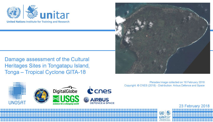
Évaluation des dommages causés aux sites du patrimoine culturel de l'île de Tongatapu
Télécharger le rapport complet
Copyright: Pleiades © CNES (2018) - Distribution: Airbus Defence and Space, tous droits réservés
WorldView-3 © DigitalGlobe Inc.
Carte produite par UNITAR/UNOSAT
Information about the Product
Acquired: Pleiades: 15/02/2018 et 16/02/2018
WorldView-3: 12/01/2018
Source: Pleiades / WorldView-3
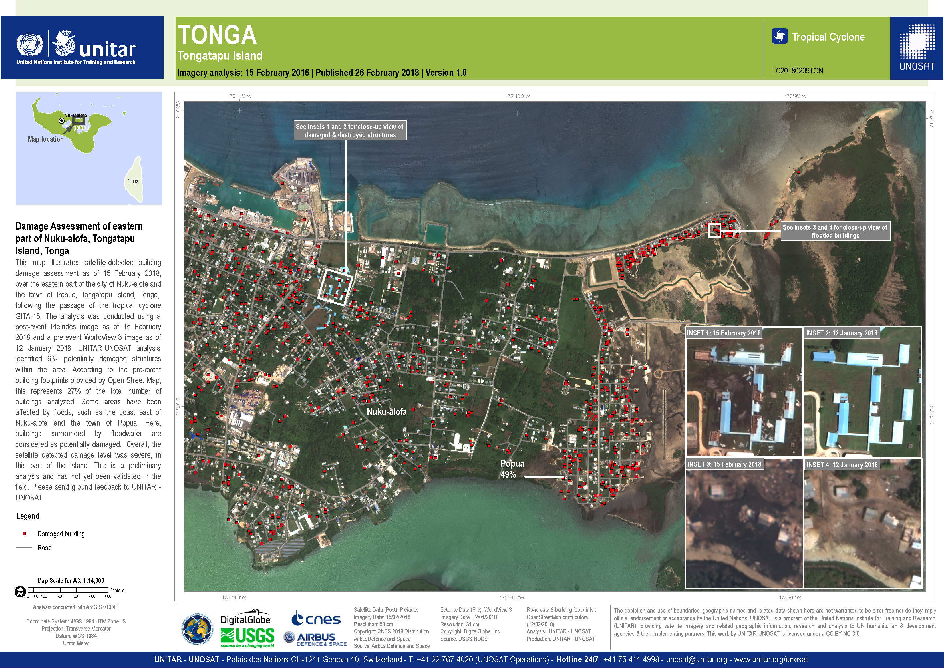
Évaluation des dommages causés à l'est de Nuku-alofa, île de Tongatapu
Copyright: Pleiades © CNES (2018) - Distribution: Airbus Defence and Space, tous droits réservés
WorldView-3 © DigitalGlobe Inc.
Carte produite par UNITAR/UNOSAT
Information about the Product
Acquired: Pleiades: 15/02/2018
WorldView-3: 12/01/2018
Source: Pleiades / WorldView-3
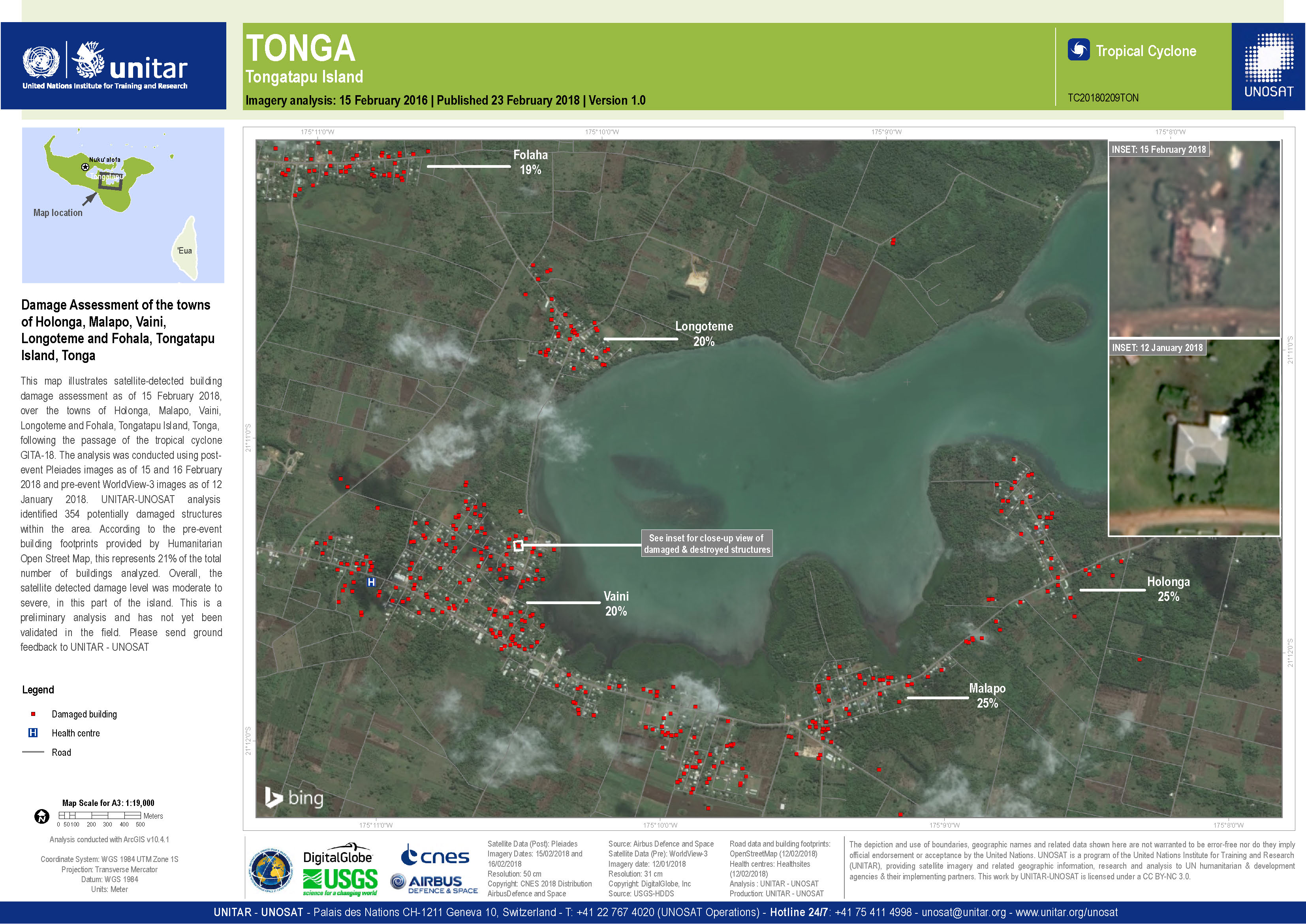
Évaluation des dommages subis par les villes de Holonga, Malapo, Vaini, Longoteme et Fohala, île de Tongatapu
Copyright: WorldView-3 © DigitalGlobe Inc.
Pleiades © CNES (2018) - Distribution: Airbus Defence and Space, tous droits réservés
Carte produite par UNITAR/UNOSAT
Information about the Product
Acquired: WorldView-3: 12/01/2018
Pleiades: 15/02/2018
Source: WorldView-3 / Pleiades
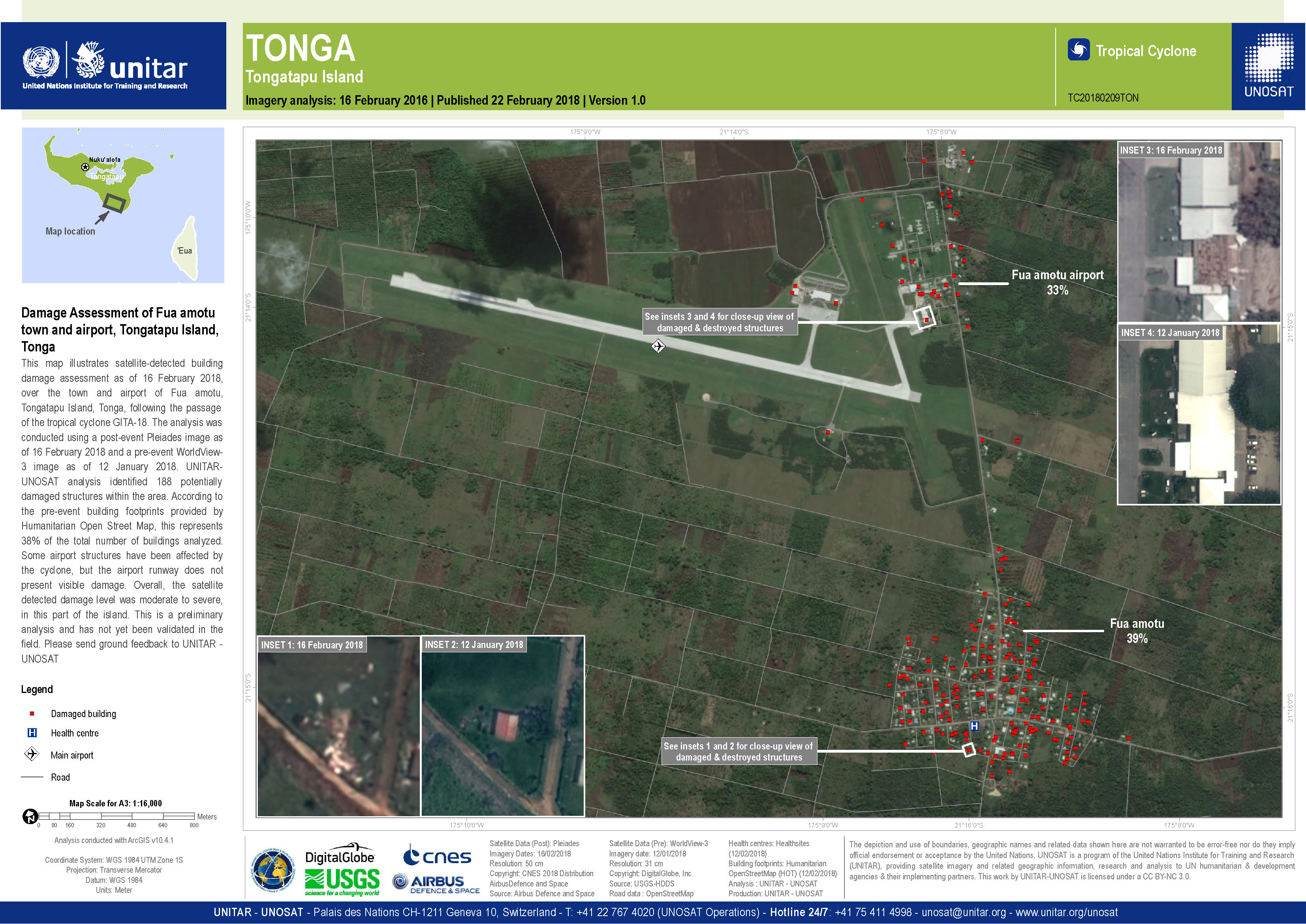
Évaluation des dommages causés à la ville et à l'aéroport de Fua amotu, île Tongatapu
Copyright: WorldView-3 © DigitalGlobe Inc.
Pleiades © CNES (2018) - Distribution: Airbus Defence and Space, all rights reserved
Map produced by UNITAR/UNOSAT
Information about the Product
Acquired: WorldView-3: 12/01/2018
Pleiades: 16/02/2018
Source: WorldView-3 / Pleiades

Évaluation des dommages causés aux villes de Nukuleka, Hoi, Mua et Alaki, île de Tongatapu
Copyright: WorldView-3 © DigitalGlobe Inc.
Pleiades © CNES (2018) - Distribution: Airbus Defence and Space, tous droits réservés
Carte produite par UNITAR/UNOSAT
Information about the Product
Acquired: WorldView-3: 12/01/2018
Pleiades: 15/02/2018 et 16/02/2018
Source: WorldView-3 / Pleiades
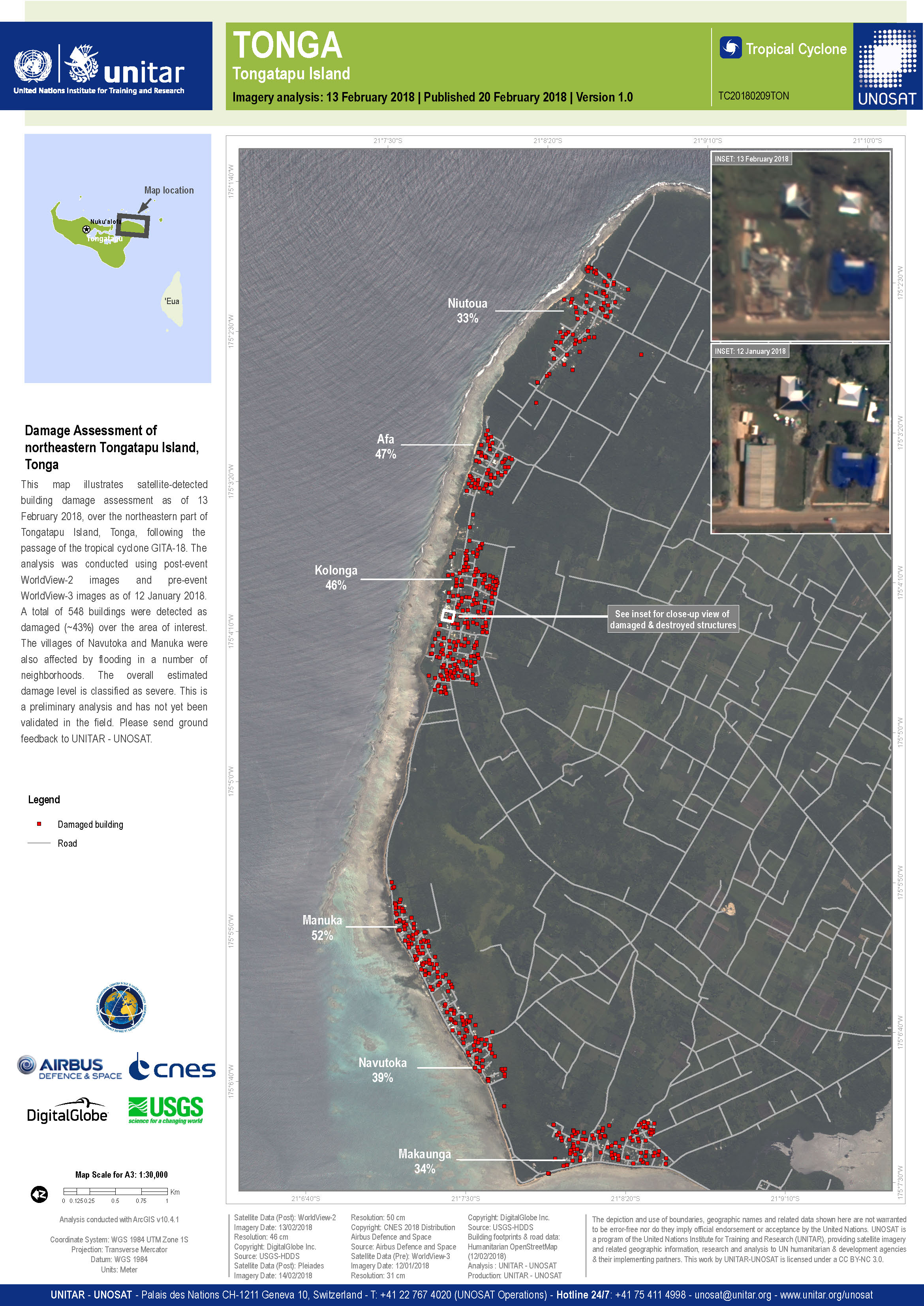
Évaluation des dommages de l'île Tongatapu
Copyright: WorldView-2 and -3 © DigitalGlobe Inc.
Pleiades © CNES (2018) - Distribution: Airbus Defence and Space, tous droits réservés
Carte produite par UNITAR/UNOSAT
Information about the Product
Acquired: WorldView-2: 13/02/2018
WorldView-3: 12/01/2018
Pleiades: 14/02/2018
Source: WorldView-2 / WorldView-3 / Pleiades

Évaluation des dommages de l'île, Lavengatonga et Nakolo les villes
Copyright: WorldView-2 © DigitalGlobe Inc.
Carte produite par UNITAR/UNOSAT
Information about the Product
Acquired: 13/02/2018
Source: WorldView-2
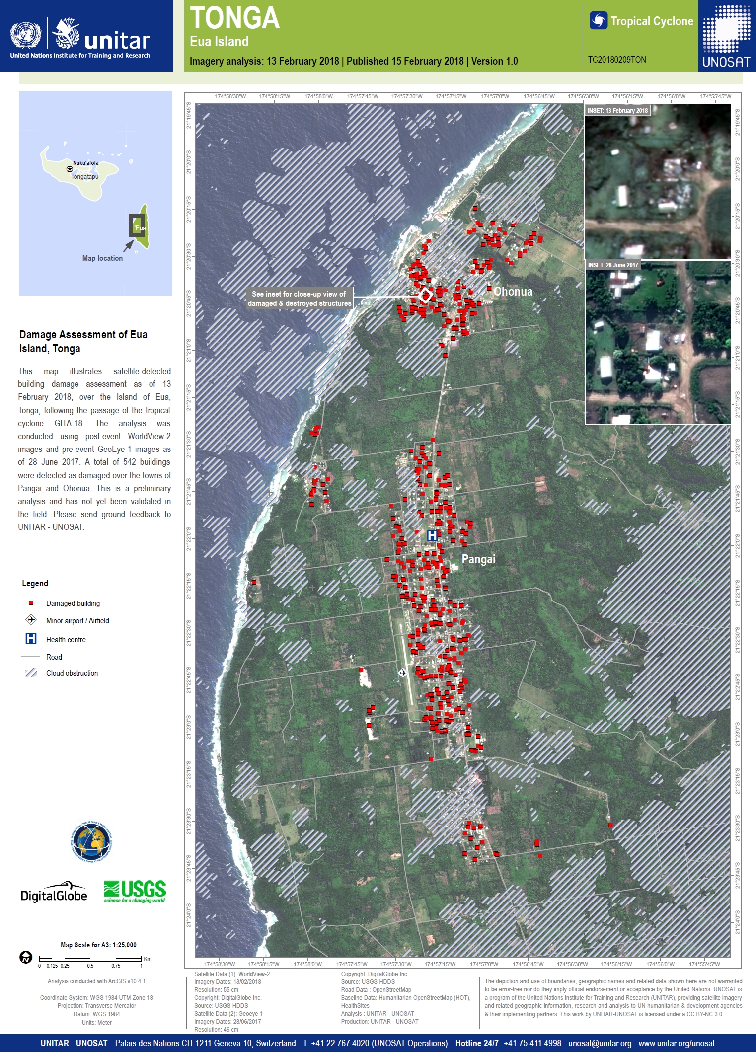
Évaluation des dommages de l'île Eua
Copyright: GeoEye-1 et WorldView-2 © DigitalGlobe Inc.
Carte produite par UNITAR/UNOSAT
Information about the Product
Acquired: GeoEye-1: 28/06/2017
WorldView-2: 13/02/2018
Source: GeoEye-1 / WorldView-2
 Back to the full activation archive

