 English
 Spanish
 French
 Chinese
 Russian
 Portuguese
 Latest Activation
Charter activations
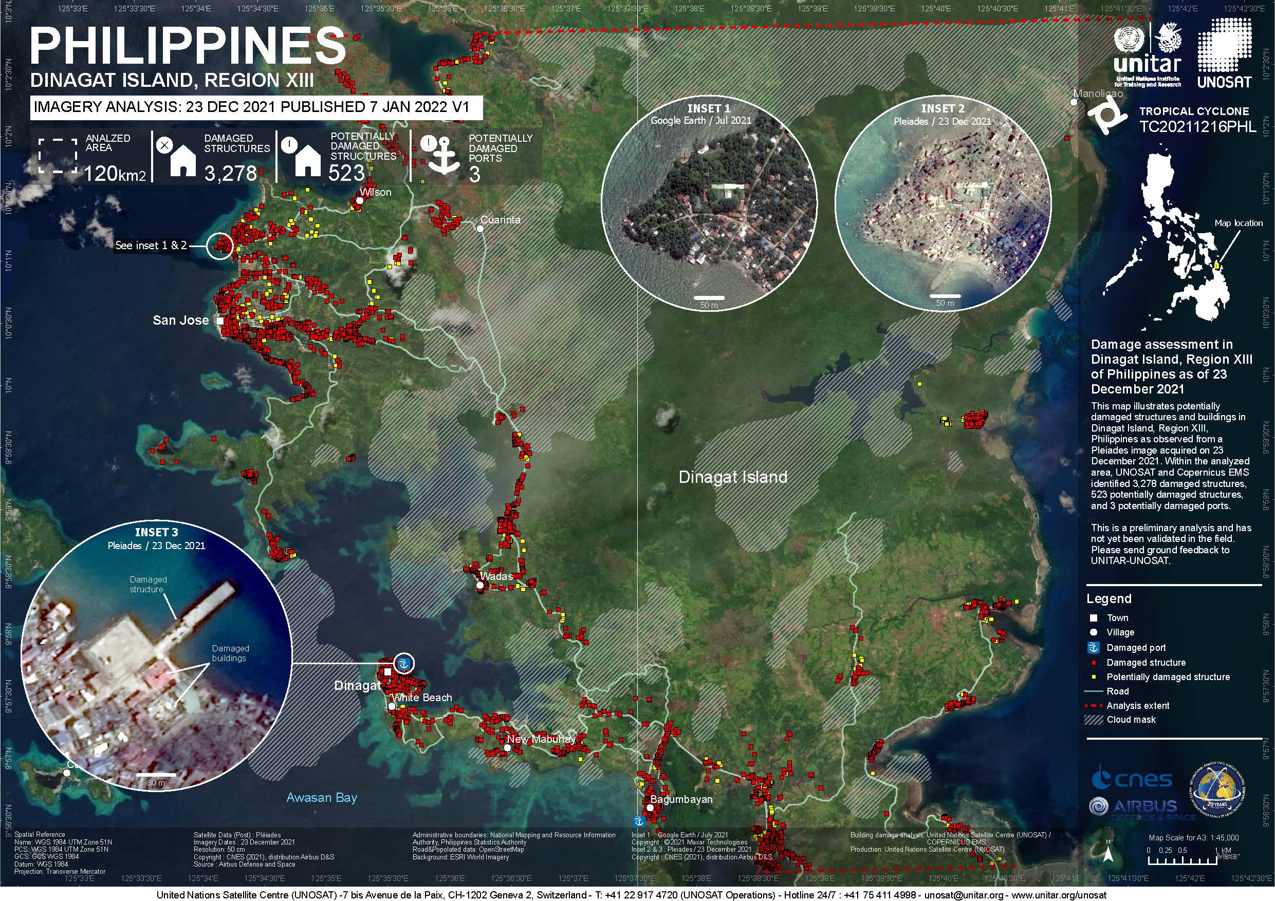
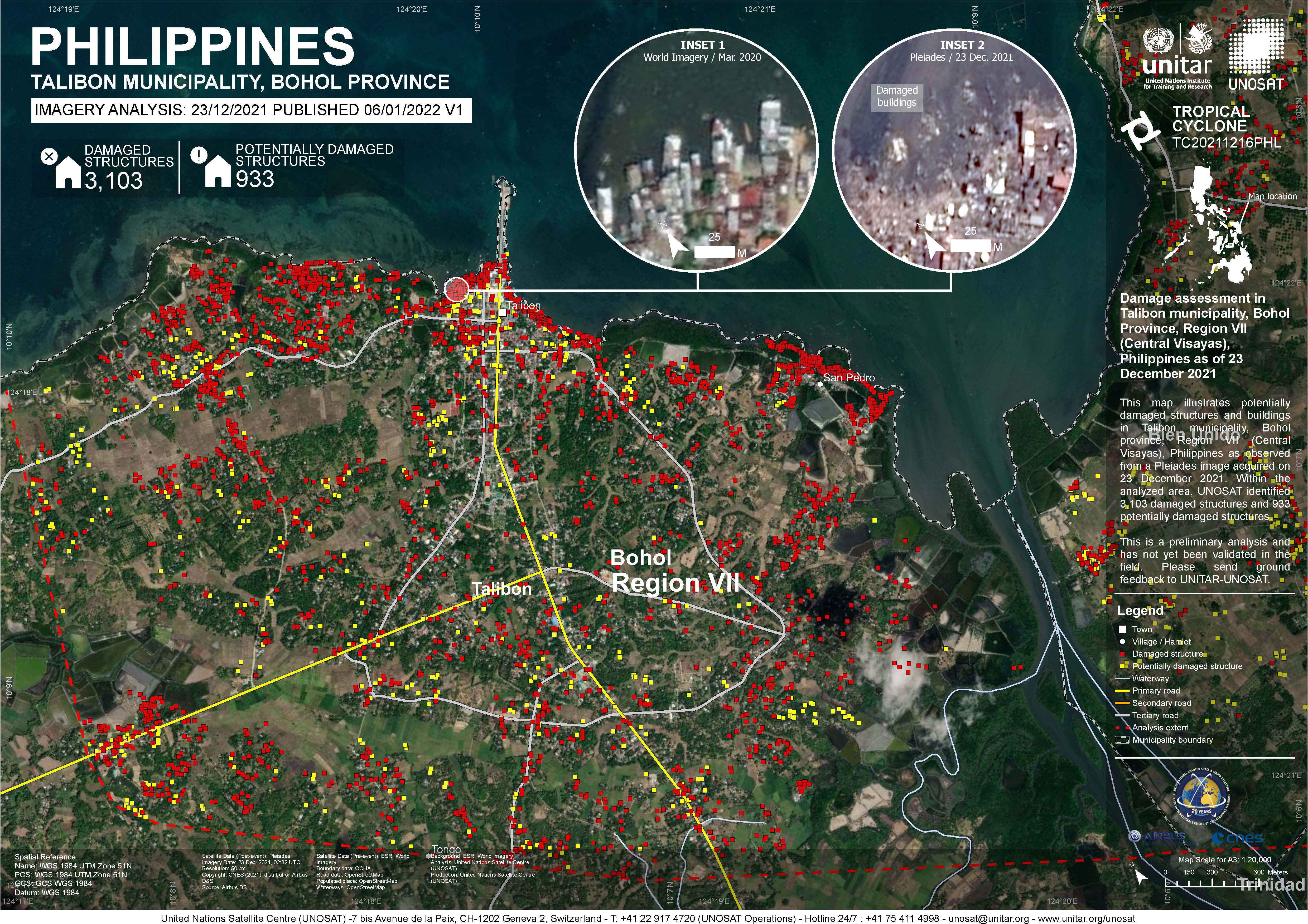
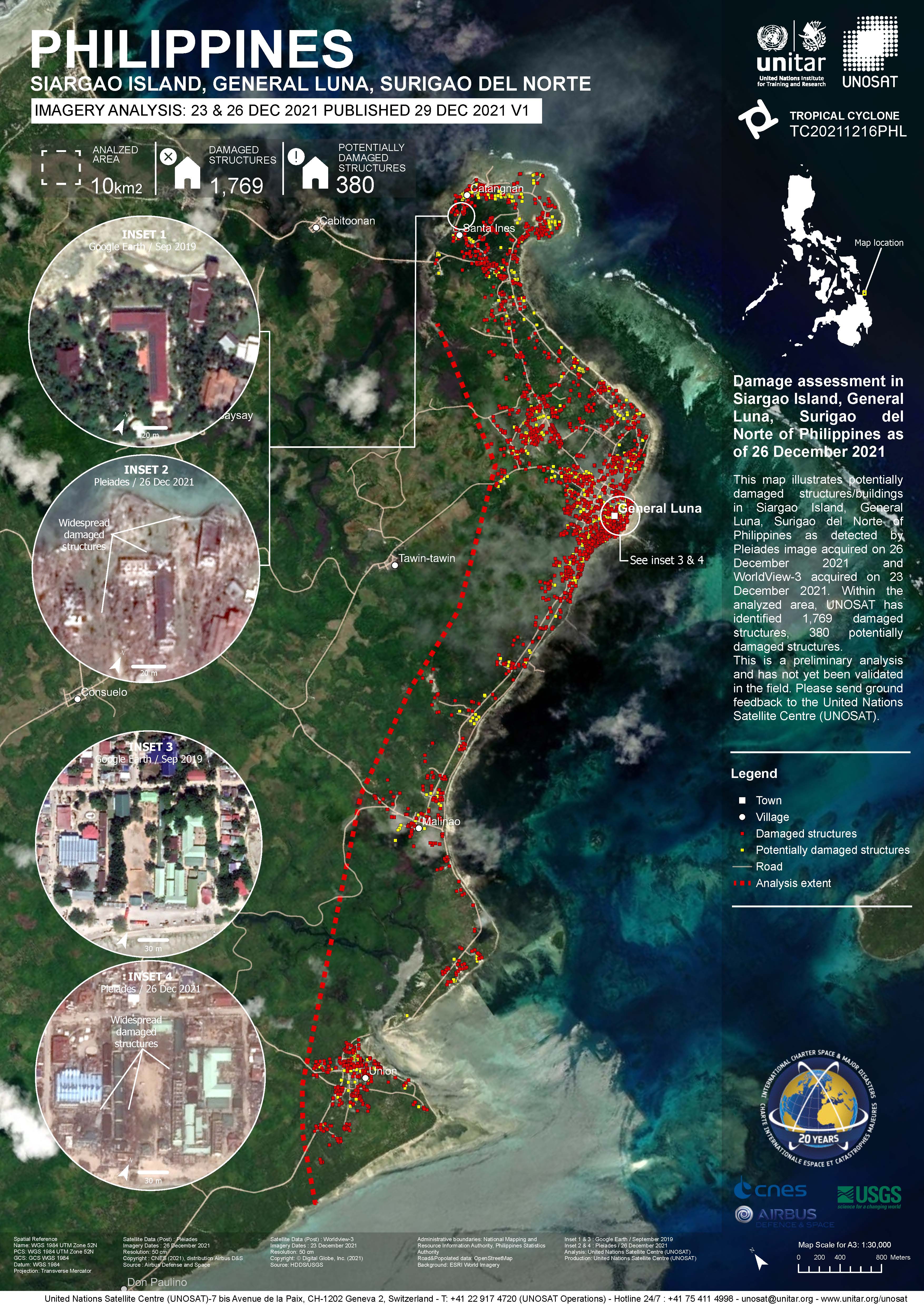
Typhoon Rai in the Philippines
Typhoon Rai (known in the Philippines as Typhoon Odette) made landfall over the Philippines on 16 December, causing at least 252 fatalities, floods and damage across a wide part of the southern Philippines.
Rai was a Category 5 Super Typhoon when it made landfall, but people had been urged to evacuate two days earlier and mandatory evacuations began on 15 December as the storm grew in strength. It is estimated that almost 500,000 people had to leave their homes to find shelter or move to safer ground.
Surigao City lost all power and communications when the storm struck, with power lines knocked down. Houses in coastal areas were destroyed, and many roads were blocked off by debris. It was estimated that 99% of the people in Surigao were affected by the storm.
Rai affected six provinces in total, with damage reported to Bohol, Cebu, Negros Oriental, Negros Occidental, Siargao, and Dinagat Islands.
| Type of Event: | Ocean Storm - Typhoon |
| Location of Event: | Philippines |
| Date of Charter Activation: | 2021-12-16 |
| Time of Charter Activation: | 14:46 |
| Time zone of Charter Activation: | UTC+01:00 |
| Charter Requestor: | UNITAR on behalf of United Nations Office for the Coordination of Humanitarian Affairs (OCHA) | Regional Office for Asia and the Pacific |
| Activation ID: | 741 |
| Project Management: | UNITAR |
Products


Damage assessment in Bien Unido, Trinidad and Ubay municipalities, Bohol Province, Region VII, Philippines
Copyright: Includes Pleiades material © CNES (2021), Distribution Airbus DS.
Map produced by UNITAR / UNOSAT
Information about the Product
Acquired: 23/12/2021
Source: Pleiades
Category: Grading Map

Damage assessment in Jimalalud and La Libertad Municipalities, Negros Oriental Province, Region VII, the Philippines
Copyright: Includes Pleiades material © CNES (2021), Distribution Airbus DS.
Map produced by UNITAR / UNOSAT
Information about the Product
Acquired: 22/12/2021
Source: Pleiades
Category: Grading Map

Damage assessment in City of Carcar and San Fernando Municipalities, Cebu Province, Region VII of the Philippines
Copyright: © 2021 GeoEye
NextView License
Includes Pleiades material © CNES (2021), Distribution Airbus DS.
Map produced by UNITAR / UNOSAT
Information about the Product
Acquired: GeoEye-1: 20/12/2021
Pleiades: 23/12/2021
Source: Pleiades / GeoEye-1
Category: Reference Map
Damage assessment in Siargao island, General Luna, Surigao Del Norte of the Philippines
Copyright: Includes Pleiades material © CNES (2021), Distribution Airbus DS.
© (year of acquistion) DigitalGlobe, Inc., Longmont CO USA 80503. DigitalGlobe and the DigitalGlobe logos are trademarks of DigitalGlobe, Inc. The use and/or dissemination of this data and/or of any product in any way derived there from are restricted. Unauthorized use and/or dissemination is prohibited
Map produced by UNITAR/ UNOSAT
Information about the Product
Acquired: WorldView-3: 23/12/2021
Pleiades: 26/12/2021
Source: Pleiades / WorldView-3
Category: Grading Map
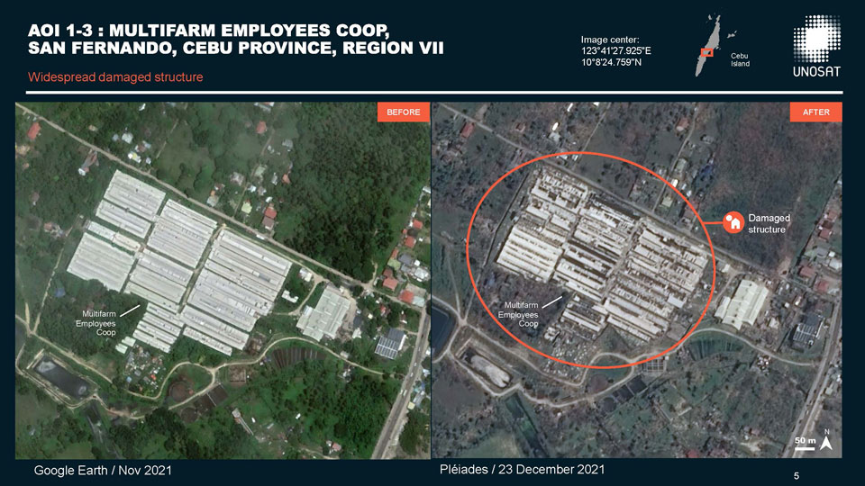
Preliminary satellite-derived industrial sites impact analysis in Cebu and Naga cities, Cebu, Region VII, Philippines following Typhoon Rai
Download the full report
Copyright: Includes Pleiades material © CNES (2021), Distribution Airbus DS.
Report produced by UNITAR/UNOSAT
Information about the Product
Acquired: 21/12/2021 and 23/12/2021
Source: Pleiades
Category: Dossier

Damage assessment in city of Talisay Municipality, Cebu Province, Region VII, the Philippines
Copyright: © 2021 GeoEye NextView License
Includes Pleiades material © CNES (2021), Distribution Airbus DS.
Map produced by UNITAR/UNOSAT
Information about the Product
Acquired: GeoEye-1: 20/12/2021
Pleiades: 21/12/2021
Source: GeoEye-1 / Pleiades
Category: Grading Map

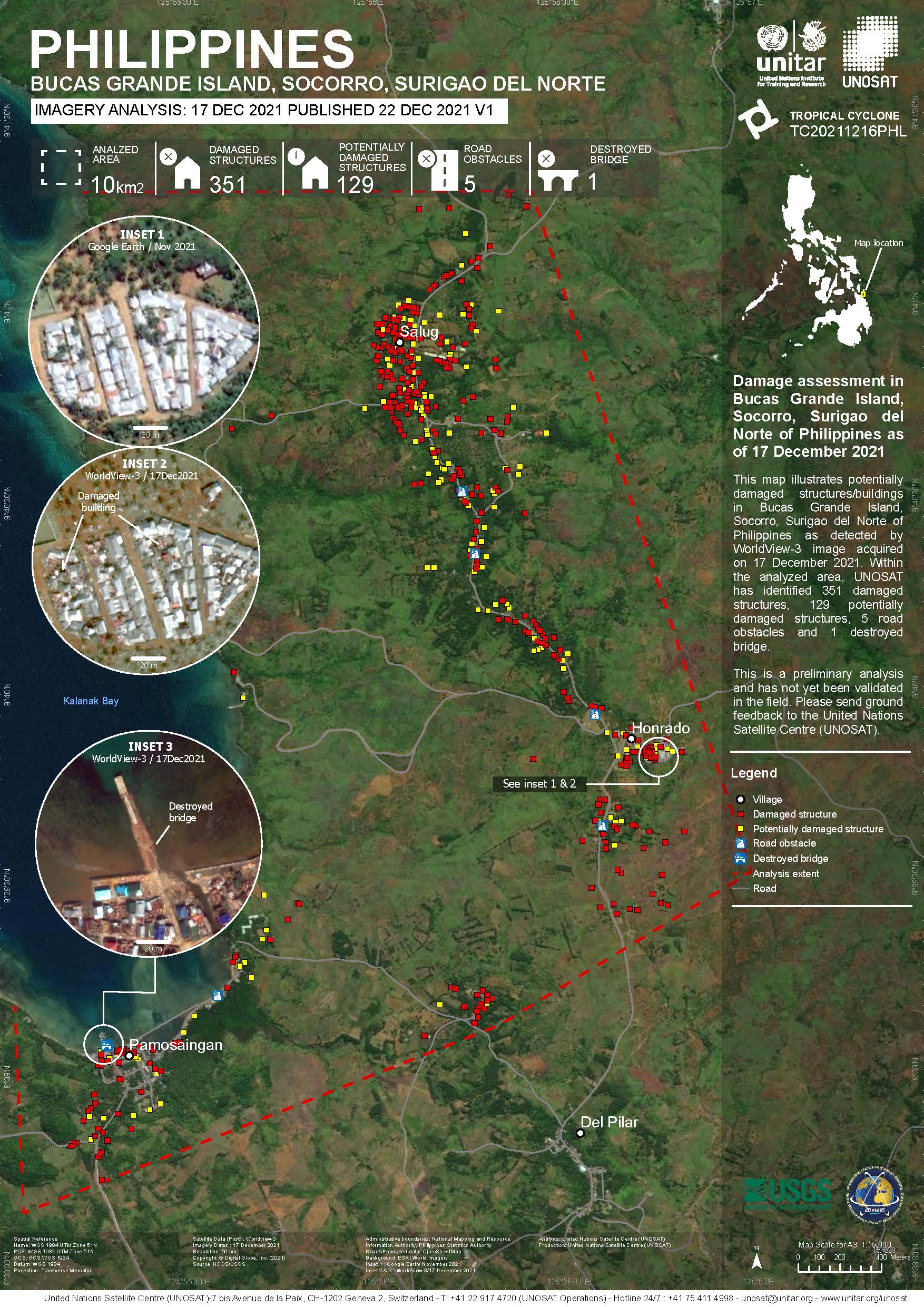
Damage assessment in Bucas Grande Island, Socorro, Surigao Del Norte of the Philippines
Copyright: WorldView-3 © (2021) DigitalGlobe, Inc., Longmont CO USA 80503. DigitalGlobe and the DigitalGlobe logos are trademarks of DigitalGlobe, Inc. The use and/or dissemination of this data and/or of any product in any way derived there from are restricted. Unauthorized use and/or dissemination is prohibited
Map produced by UNITAR/UNOSAT
Information about the Product
Acquired: 17/12/2021
Source: WorldView-3
Category: Grading Map

Preliminary satellite-derived building damage analysis in Siargao Island and Negros Oriental Province, in the Philippines, following Typhoon Rai
Download the full report
Copyright: © 2021 GeoEye
NextView License
Repot produced by UNITAR/UNOSAT
Information about the Product
Acquired: 19/12/2021
Source: GeoEye-1
Category: Dossier

Preliminary satellite-derived building damage analysis of Cebu and Palawen Province, in the Philippines, following Typhoon Rai
Download the full report
Copyright: WorldView-3 © (2021) DigitalGlobe, Inc., Longmont CO USA 80503. DigitalGlobe and the DigitalGlobe logos are trademarks of DigitalGlobe, Inc. The use and/or dissemination of this data and/or of any product in any way derived there from are restricted. Unauthorized use and/or dissemination is prohibited
Includes Pleiades material © CNES (2021), Distribution Airbus DS.
Report produced by UNITAR/UNOSAT
Information about the Product
Acquired: WorldView-3: 17/12/2021
Pleiades: 21/12/2021
Source: WorldView-3 / Pleiades
Category: Dossier
Preliminary satellite-derived standing waters analysis, Mimaropa and Central Visayas, Philippines, following Tropical Cyclone Rai
Download the full report
Copyright: Contains modified Copernicus Sentinel data (2021)
Report produced by UNITAR/UNOSAT
Information about the Product
Acquired: 20/11/2021, 22/11/2021, 28/11/2021, 17/12/2021, 18/12/2021, 20/12/2021
Source: Sentinel-2
Category: Dossier

Preliminary satellite-derived standing waters analysis in Philippines, following Tropical Cyclone Rai
Download the full report
Copyright: Includes material © AIRBUS DS (2021)
Report produced by UNITAR/UNOSAT
Information about the Product
Acquired: SPOT-6: 19/12/2021
SPOT-7: 18/12/2021, 20/12/2021
Source: SPOT-6 / SPOT-7
Category: Dossier
Preliminary satellite-derived standing waters analysis in Philippines following Typhoon Rai
Download the full report
Copyright: Contains modified Copernicus Sentinel data (2021)
Report produced by UNITAR/UNOSAT
Information about the Product
Acquired: 17/12/2021
Source: Sentinel-2
Category: Dossier
 Back to the full activation archive

