最小化 Flood in Kenya
« 返回

Flood in Kenya

Charter activations

Flood in Kenya

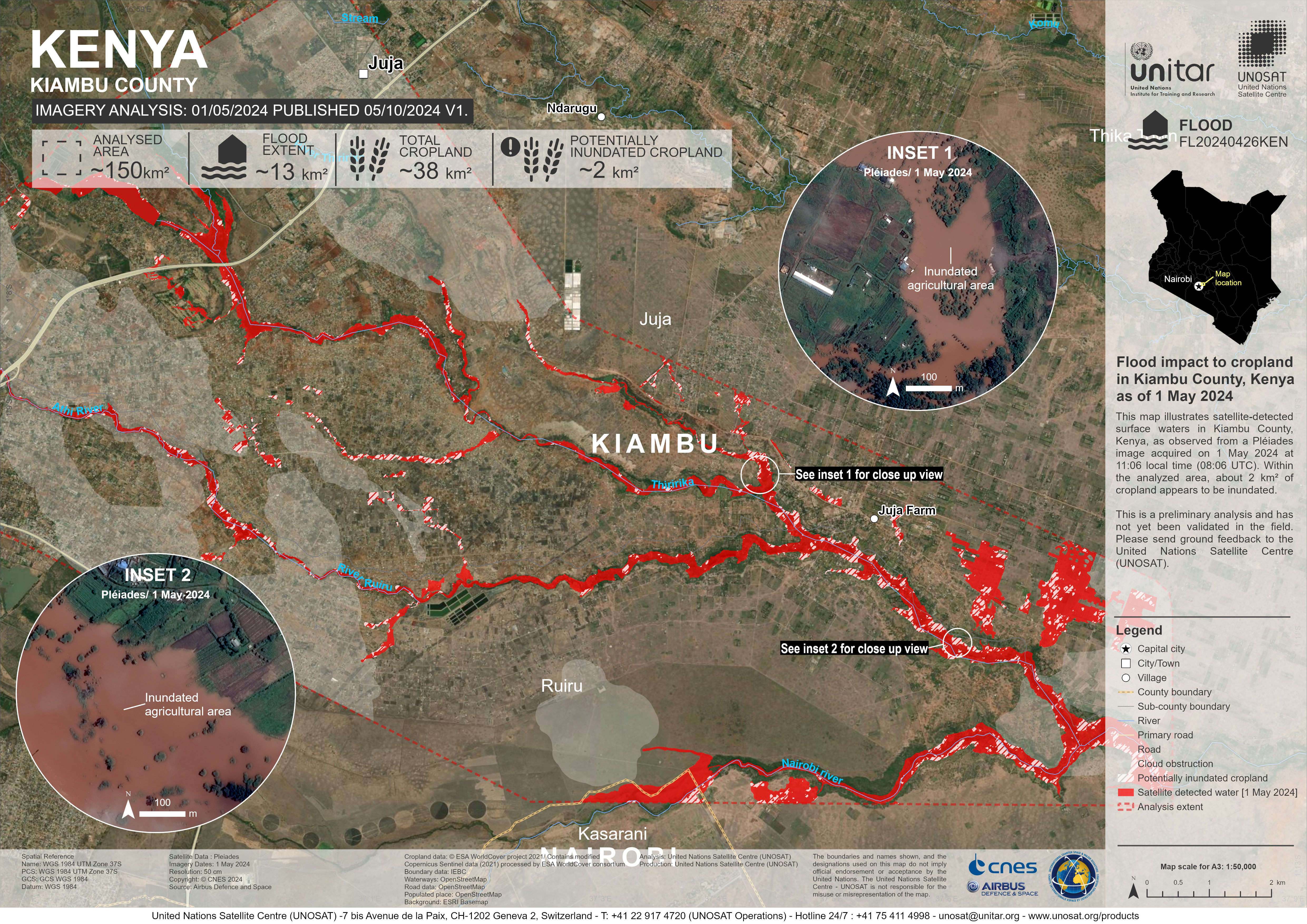
During the early hours of 29 April, a powerful flood surged downstream. The Old Kijabe Dam, located in the Mai Mahiu area of the Great Rift Valley region in Kenya, burst its banks due to heavy rainfall.

The force of the flood swept away villagers at night without warning while they slept in their homes. Fifty deaths have been recorded. Some villagers claimed to have woken from the sound of roaring water heading towards them. Rescue efforts are ongoing, but there are fears that the death toll may increase.

The impacted areas are now covered in mud, uprooted trees, and crushed houses. The Kenya Red Cross has organized search and rescue operations. They have also set up a desk at a local school to help families find lost relatives.

Related Resources:

UNOSAT Live web map for flood monitoring in Kenya

事件类型:Flood
事件地点:Kenya
启动宪章的日期:2024-04-30
宪章启动时间:18:14
宪章启动时区:UTC+07:00
宪章要求者:UNOSAT on behalf of United Nations Environment Programme
启动ID:874
项目经理:Jakrapong Tawala (UNITAR)
act-value-adders:National Disaster Operations Center of Kenya
Dalia Laoubi (CSA)
WASDI
Argans

Products

Flood impact analysis in Kiambu County, Kenya

版权: Includes Pleiades material © CNES (2024), Distribution Airbus DS.
Map produced by UNITAR / UNOSAT

Information about the Product

已获得: 01/05/2024

源: Pleiades

类别: Grading Map

Flood impact to cropland in Kiambu County, Kenya

版权: Includes Pleiades material © CNES (2024), Distribution Airbus DS.
Map produced UNITOR / UNITAR

Information about the Product

已获得: 01/05/2024

源: Pleiades

类别: Reference Map

Flood impact to cropland in Nairobi and Machakos County, Kenya

版权: Includes Pleiades material © CNES (2024), Distribution Airbus DS.
Map produced by UNITAR/ UNOSAT

Information about the Product

已获得: 01/05/2024
02/05/2024

源: Pleiades

类别: Grading Map

Flood impact analysis in Nairobi and Machakos County, Kenya

版权: Includes Pleiades material © CNES (2024), Distribution Airbus DS.
Map produced by UNITAR/ UNOSAT

Information about the Product

已获得: 01/05/2024

源: Pleiades

类别: Grading Map

Flood Impact to Cropland in Nairobi and Kiambu County, Kenya

版权: Includes Pleiades material © CNES (2024), Distribution Airbus DS.
Map produced UNITAR/ UNOSAT

Information about the Product

已获得: 01/05/2024

源: Pleiades

类别: Reference Map

Satellite detected water extent in Garissa City and Mororo Village, Kenya

版权: Includes Pleiades material © CNES (2024), Distribution Airbus DS.

Information about the Product

已获得: 05/05/2024

源: Pleiades

类别: Grading Map

Flood impact analysis in Central Nairobi, Kenya

版权: Includes Pleiades material © CNES (2024), Distribution Airbus DS.
Map produced by UNITAR/ UNOSAT

Information about the Product

已获得: 01/05/2024

源: Pleiades

类别: Grading Map

Flood impact analysis in Nairobi and Kiambu County, Kenya

版权: Includes Pleiades material © CNES (2024), Distribution Airbus DS.
Map produced by UNITAR/ UNOSAT

Information about the Product

已获得: 01/05/2024

源: Pleiades

类别: Grading Map

Landslide/mudslide Impact in Mai Mahiu and Kijabe Towns, Kenya

版权: Includes Pleiades material © CNES (2024), Distribution Airbus DS.

Information about the Product

已获得: 01/05/2024

源: Pleiades

类别: Grading Map

Satellite detected water extent in Garissa City and Mororo Village, Kenya

版权: Contains modified Copernicus Sentinel data (2024)
Map produced by UNITAR / UNOSAT

Information about the Product

已获得: 29/04/2024

源: Sentinel-2

类别: Delineation Map

返回完整的响应档案