 English
 Spanish
 French
 Chinese
 Russian
 Portuguese
 Flooding in Brazil
Flooding in Brazil
Charter activations
Flooding in Brazil
A storm hit the Rio Grande do Sul state in Brazil on 29 April.
Torrential rains poured down across 76 cities, resulting in mass flooding. 5 deaths have been reported, many injured and 18 people still missing. Nearly 100 residents were forced to evacuate their homes, and an additional 200 sought refuge in shelters.
Heavy rains lead to the Barramansa River bursting its banks and flooding local roads, the overflowed water collided with a bridge's foundations and completely detach it from the road.
| 事件类型: | Flood |
| 事件地点: | Brazil |
| 启动宪章的日期: | 2024-04-30 |
| 宪章启动时间: | 16:30 |
| 宪章启动时区: | UTC-03:00 |
| 宪章要求者: | CENAD |
| 启动ID: | 875 |
| 项目经理: | Artur Matos (SGB - Serviço Geológico Brasileiro) |
| act-value-adders: | Alisson deOliveira (INPE) Julio Cesar Lana (SGB) Laercio Massaru Namikawa (INPE) Camila Gonçalves dos Santos (UFRRJ) Mailson Moura (CENSIPAM) Ulisses Guimarães (CENSIPAM) Copernicus EMS UFRGS Igor Lisboa (CENSIPAM) DianaArlette CorderoDevesa (CENAPRED) Luna Alves (Serviço Geológico Brasileiro - SGB) Manoel Araújo Sousa Júnior (Federal University of Santa Maria) Silvia Pardi LaCruz (Federal University of Santa Maria) Sidnei Gass (UNIPAMPA) Giovanna Albuquerque (CENSIPAM) Brenda Rocha (INPE) ANA NOAA INPE |
| Activation handled in collaboration with Copernicus Emergency Management Service |
Products
Post-flood Airports in the Metropolitan Region of Porto Alegre - RS - Brazil
版权: © (2024) DigitalGlobe, Inc., Longmont CO USA 80503. DigitalGlobe and the DigitalGlobe logos are trademarks of DigitalGlobe, Inc. The use and/or dissemination of this data and/or of any product in any way derived there from are restricted. Unauthorized use and/or dissemination is prohibited
Map produced by INPE
Information about the Product
已获得: 02/06/2024
源: WorldView-2
类别: Delineation Map


Cachoeirinha, Alvorada e Canoas, Brazil
版权: ©CGSTL (2024)
Map produced by INPE
Information about the Product
已获得: 15/05/2024
源: Vision-1
类别: Reference Map

Flooding Event in Encantado - RS - Brazil
版权: © (2024) DigitalGlobe, Inc., Longmont CO USA 80503. DigitalGlobe and the DigitalGlobe logos are trademarks of DigitalGlobe, Inc. The use and/or dissemination of this data and/or of any product in any way derived there from are restricted. Unauthorized use and/or dissemination is prohibited.
Map produced by INPE
Information about the Product
已获得: 07/05/2024
源: WorldView
类别: Delineation Monitoring Maps

Floods in the municipality of Colinas
版权: BlackSky Technology Inc. (on behalf of itself and its Affiliates, collectively "BlackSky") provides notification that its imagery and logos are trademarked and under copyrights of BlackSky. The further use and/or dissemination of this imagery and/or any product in any way derived there from are restricted without express prior written permission.
Map produced by INPE
Information about the Product
已获得: 06/05/2024
源: GLOBAL
类别: Reference Map

Floods in the municipality of São Leopoldo
版权: BlackSky Technology Inc. (on behalf of itself and its Affiliates, collectively "BlackSky") provides notification that its imagery and logos are trademarked and under copyrights of BlackSky. The further use and/or dissemination of this imagery and/or any product in any way derived there from are restricted without express prior written permission.
Map produced by INPE
Information about the Product
已获得: 08/05/2024
源: GLOBAL
类别: Reference Map


Flooded areas evolution in the Grande Porto Alegre and Guaíba region
版权: RADARSAT Constellation Mission Imagery © Government of Canada (2024) - RADARSAT is an official mark of the Canadian Space Agency
RADARSAT Constellation Mission Imagery © Government of Canada (2024) - RADARSAT is an official mark of the Canadian Space Agency
© DLR e.V. (2024), Distribution Airbus DS Geo GmbH
Map produced by INPE
Information about the Product
已获得: RCM: 04/05/2024
16/05/2024
TerraSAR-X: 07/05/2024
源: RCM / TerraSAR-X
类别: Delineation Monitoring Maps

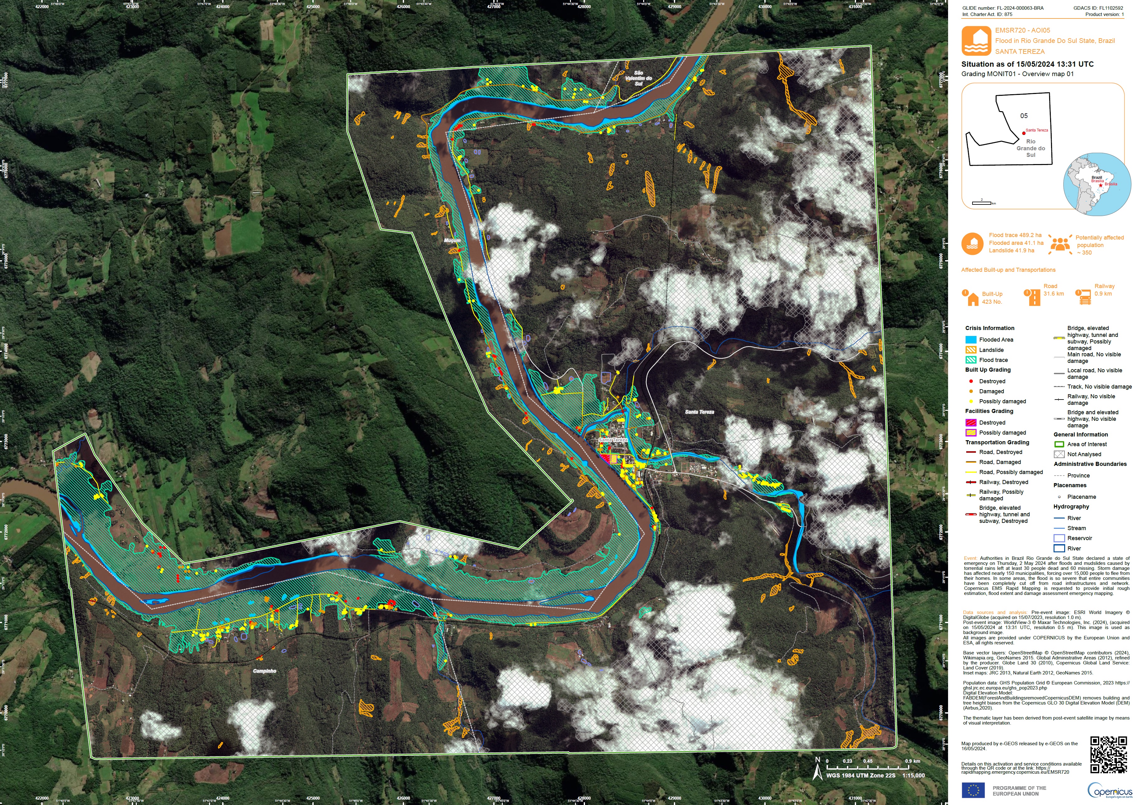
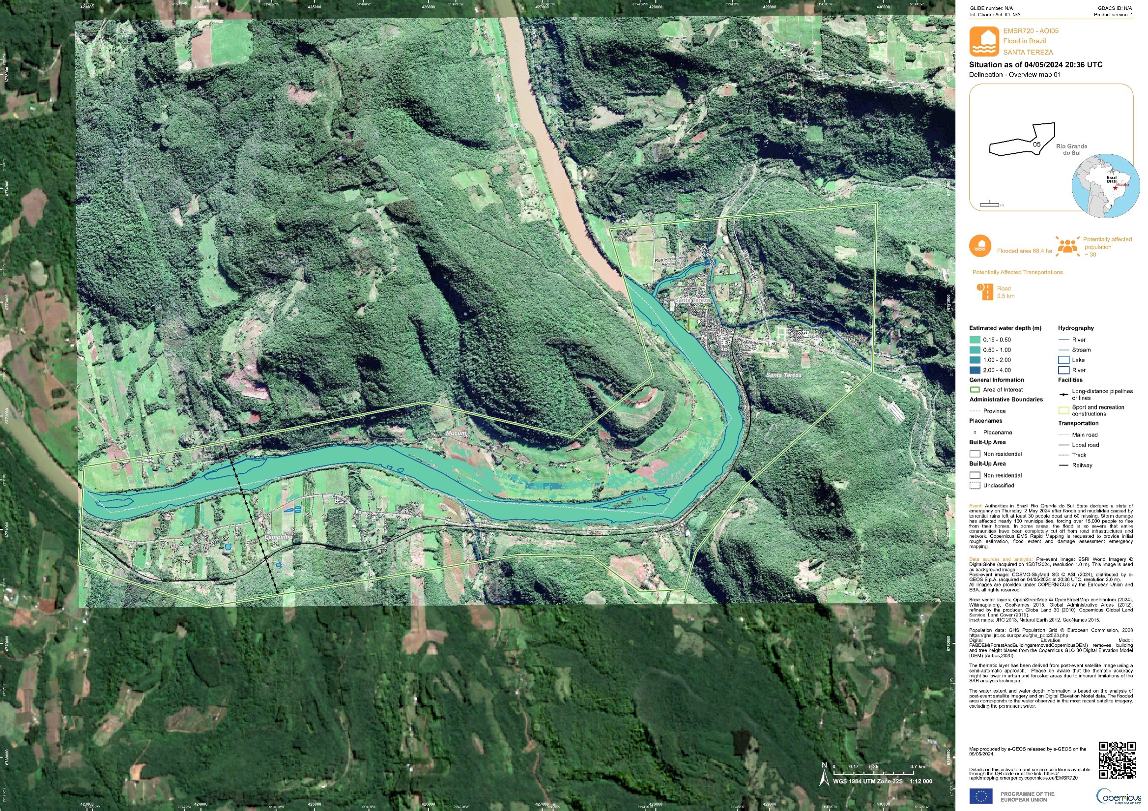
Areas affected by flooding over Santa Tereza
版权: © (2024) DigitalGlobe, Inc., Longmont CO USA 80503. DigitalGlobe and the DigitalGlobe logos are trademarks of DigitalGlobe, Inc. The use and/or dissemination of this data and/or of any product in any way derived there from are restricted. Unauthorized use and/or dissemination is prohibited.
Map produced by Copernicus EMS
Information about the Product
已获得: 15/05/2024
源: WorldView-3
类别: Gradient Monitoring Maps

Areas Affected by Flooding of the Taquari River in the Municipalities of Taquari and General Câmera - Rio Grande Do Sul State, Brazil
版权: ©2024 BlackSky Technology Inc. All Rights Reserved. Contains modified Copenicus Sentinel Data (2024)
BlackSky Technology Inc. (on behalf of itself and its Affiliates, collectively "BlackSky") provides notification that its imagery and logos are trademarked and under copyrights of BlackSky. The further use and/or dissemination of this imagery and/or any product in any way derived there from are restricted without express prior written permission.
Information about the Product
已获得: 07/05/2024
源: Sentinel-2
类别: Delineation Map

Areas Affected by Flooding in the Municipalities of Venâncio Aires, Bom Retiro do Sul and Taquar - Rio Grande do Sul, Brazil
版权: ©2024 BlackSky Technology Inc. All Rights Reserved. Contains modified Copenicus Sentinel Data (2024)
BlackSky Technology Inc. (on behalf of itself and its Affiliates, collectively "BlackSky") provides notification that its imagery and logos are trademarked and under copyrights of BlackSky. The further use and/or dissemination of this imagery and/or any product in any way derived there from are restricted without express prior written permission.
Information about the Product
已获得: 07/05/2024
源: Sentinel-2
类别: Delineation Map


Areas Affected by Landslides and Flooding of the Rio das Antas on the Limit between the Municipalities of Bento Gonçalves, Catiporã and Monte Belo do Sul - Rio Grande do Sul
版权: ©2024 BlackSky Technology Inc. All Rights Reserved. Contains modified Copenicus Sentinel Data (2024)
BlackSky Technology Inc. (on behalf of itself and its Affiliates, collectively "BlackSky") provides notification that its imagery and logos are trademarked and under copyrights of BlackSky. The further use and/or dissemination of this imagery and/or any product in any way derived there from are restricted without express prior written permission.
Map produced by INPE
Information about the Product
已获得: 07/05/2024
源: Sentinel-2
类别: Delineation Map
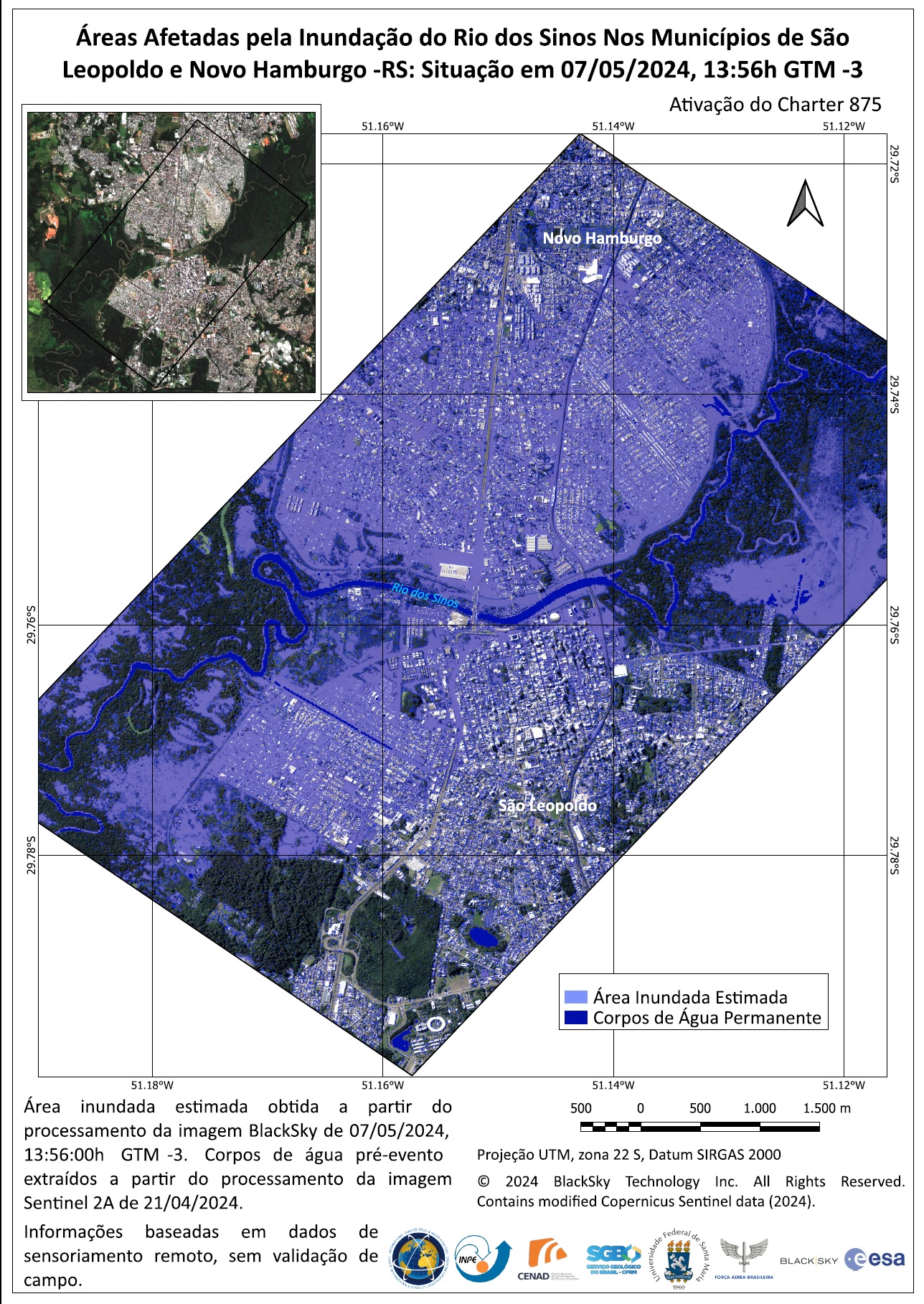
Areas Affected by the Flooding of the Rio dos Sinos In the Municipalities of São Leopoldo and Novo Hamburgo -Rio Grande do Sul
版权: ©2024 BlackSky Technology Inc. All Rights Reserved. Contains modified Copenicus Sentinel Data (2024)
BlackSky Technology Inc. (on behalf of itself and its Affiliates, collectively "BlackSky") provides notification that its imagery and logos are trademarked and under copyrights of BlackSky. The further use and/or dissemination of this imagery and/or any product in any way derived there from are restricted without express prior written permission.
Map produced by INPE
Information about the Product
已获得: 07/05/2024
源: Sentinel-2
类别: Delineation Map

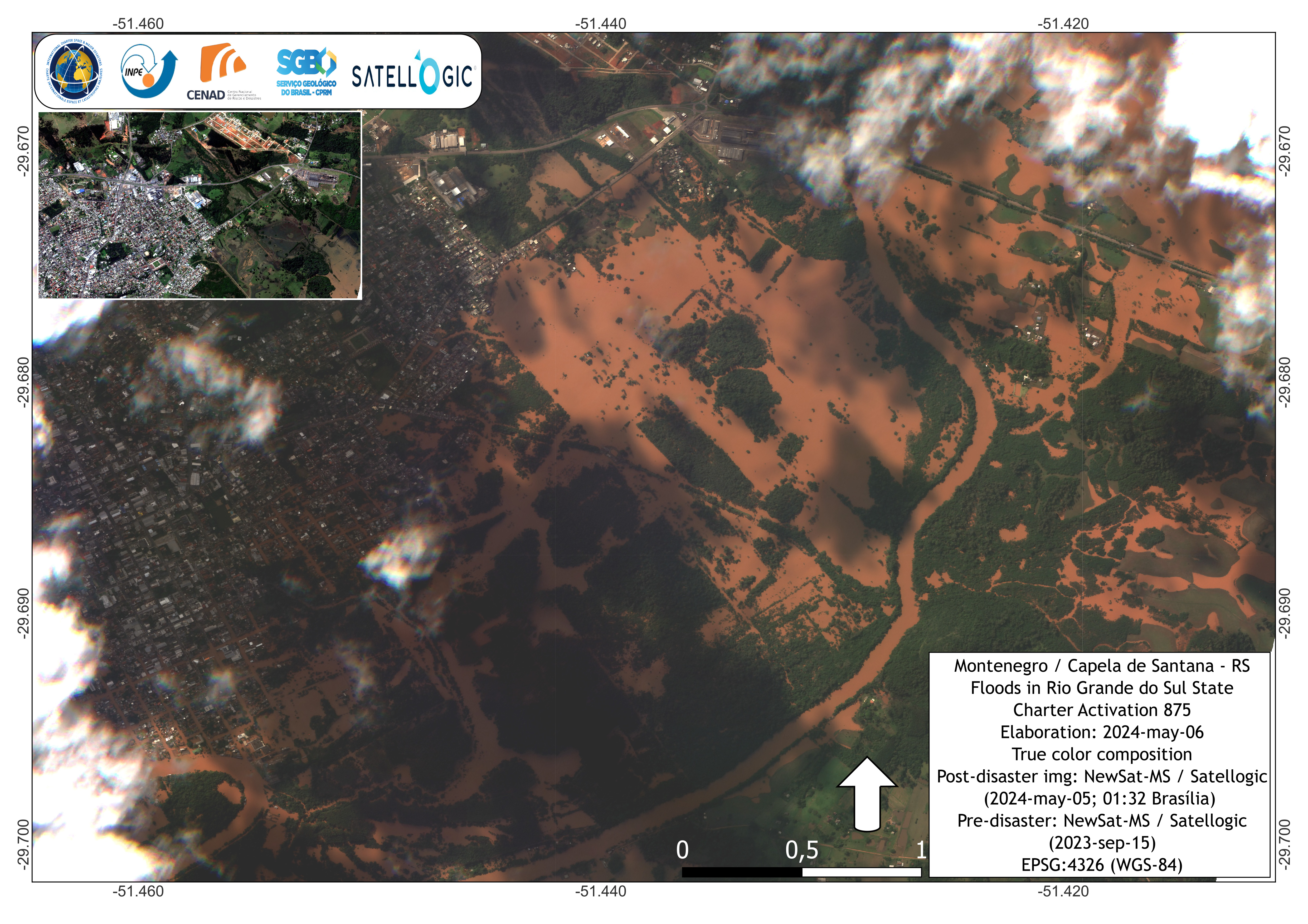
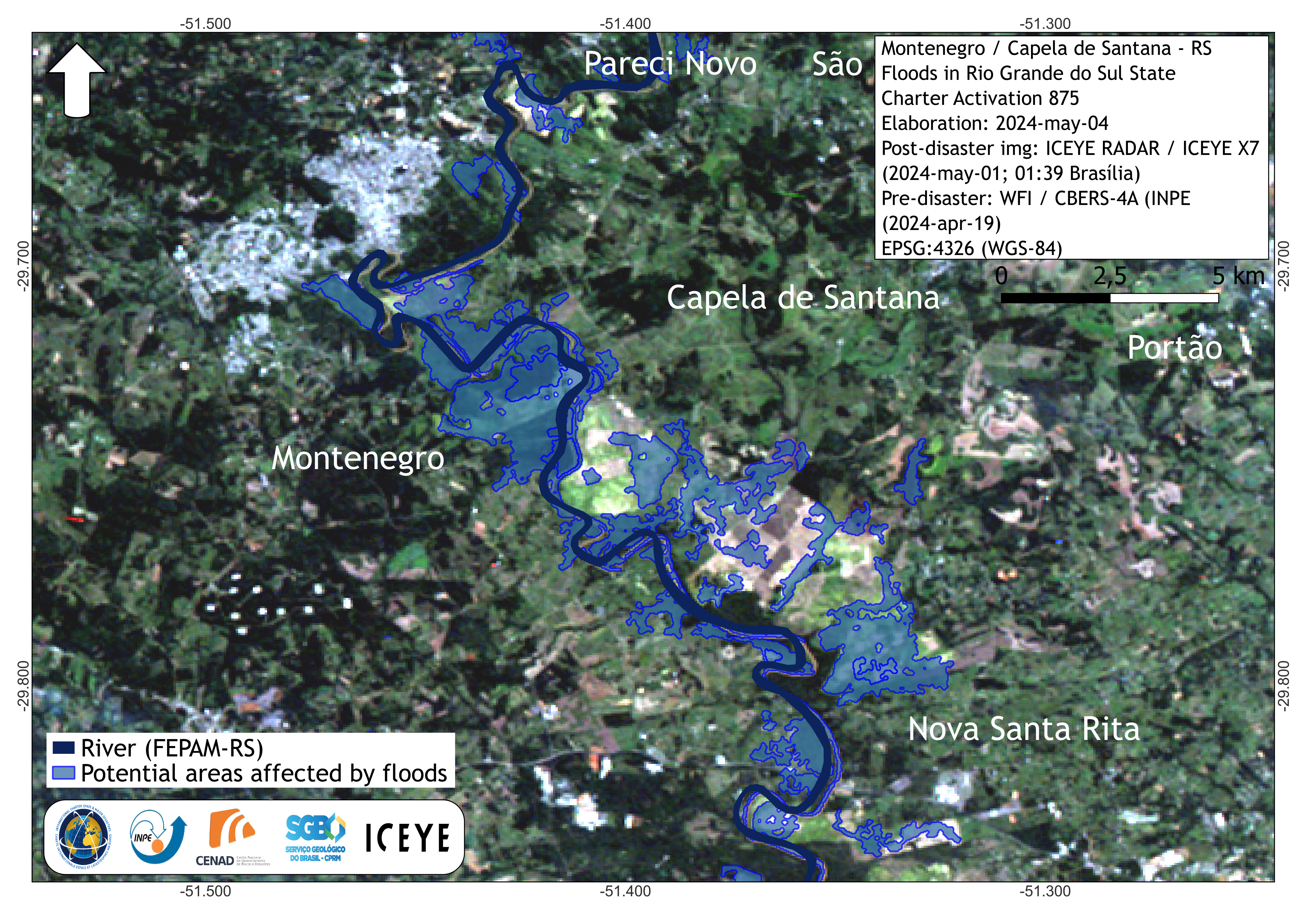
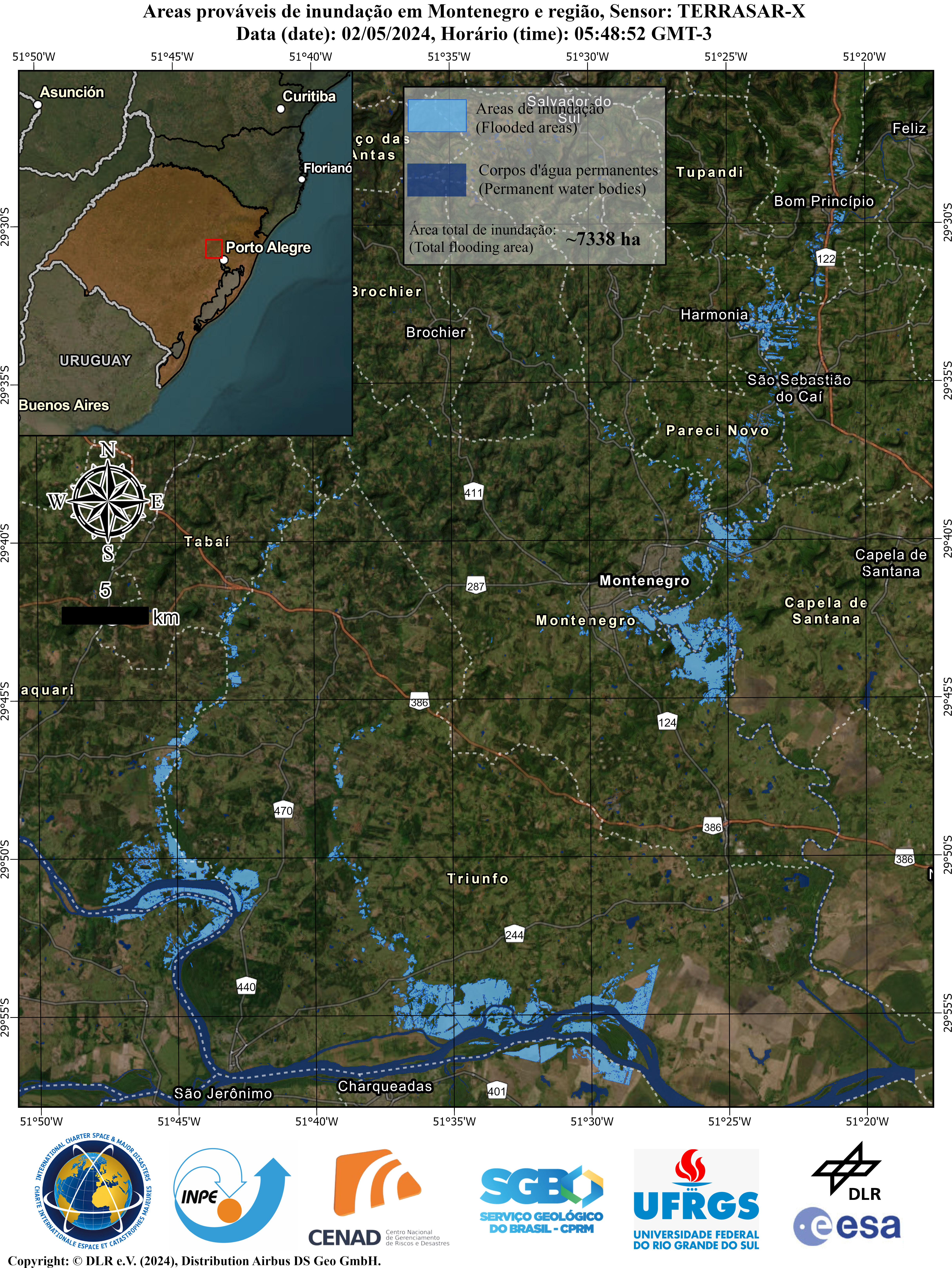
Areas affected by floods in Montenegro, Rio Grande do Sul State-Brazil
版权: VRSS-2 © ABAE (2024)
WorldView-2 © (2024) DigitalGlobe, Inc., Longmont CO USA 80503. DigitalGlobe and the DigitalGlobe logos are trademarks of DigitalGlobe, Inc. The use and/or dissemination of this data and/or of any product in any way derived there from are restricted. Unauthorized use and/or dissemination is prohibited.
Map produced by ABAE
Information about the Product
已获得: VRSS-2: 08/05/2024
WorldView-2: 24/01/2023
源: VRSS-2 / WorldView-2
类别: Reference Map


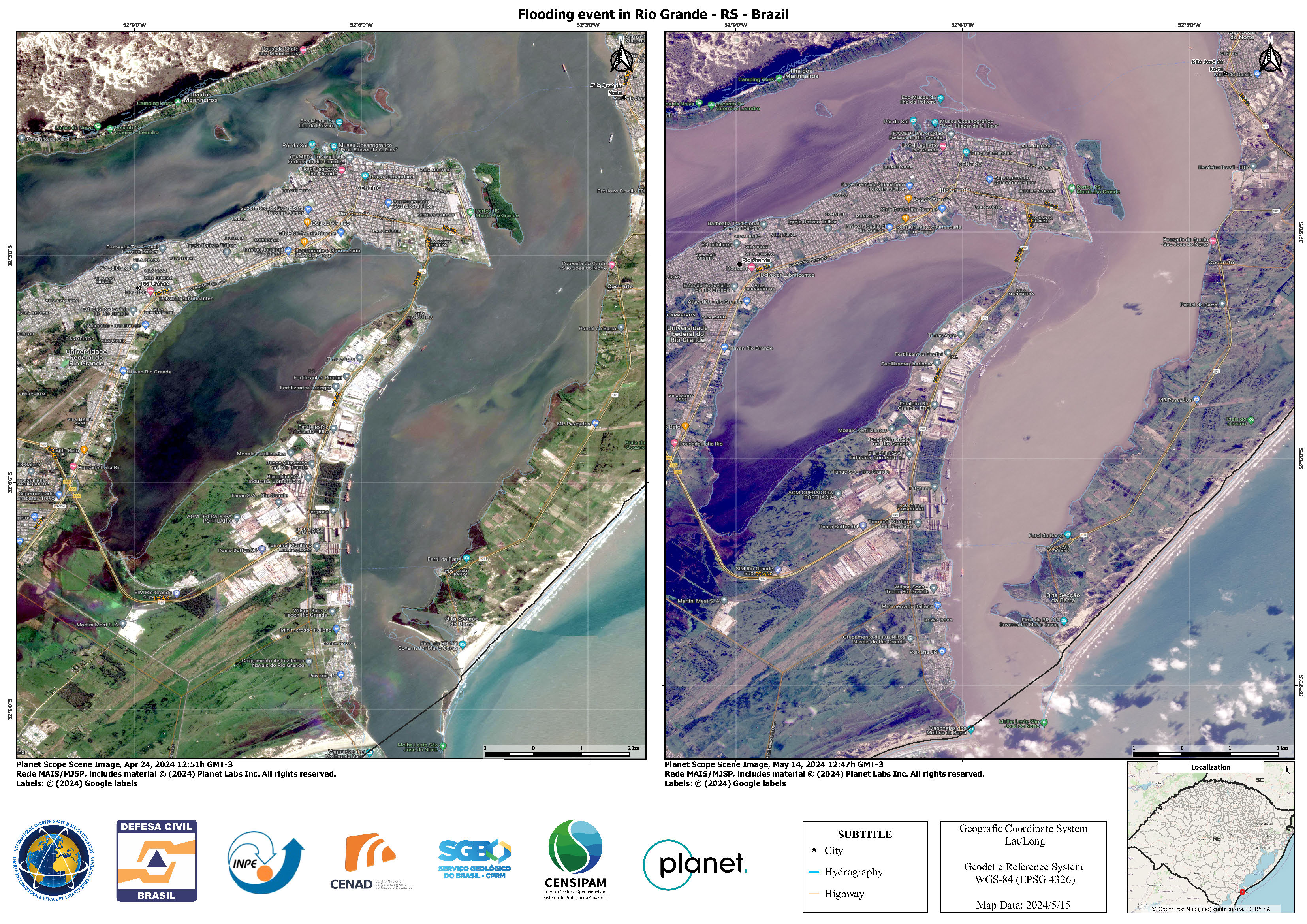
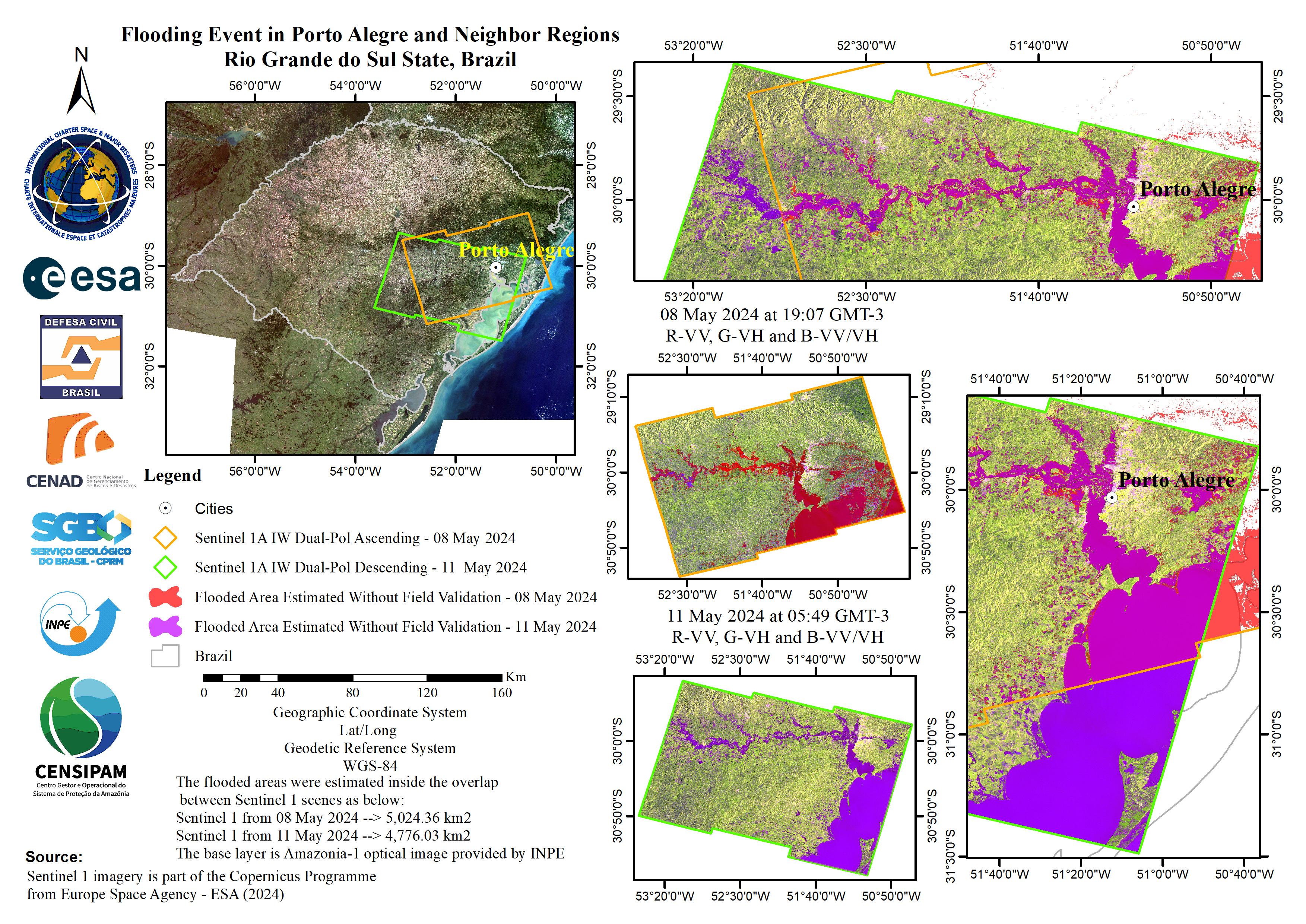
Flooding Event in Rio Grande, Pelotas and Neighbor Regions, Rio Grande do Sul State, Brazil
版权: © Planet Labs Inc. (2024)
Contains modified Copernicus Sentinel data (2024)
Map produced by INPE
Information about the Product
已获得: PlanetScope: 01/04/2024
Sentinel-1: 11/05/2024
源: PlanetScope / Sentinel-1
类别: Delineation Map

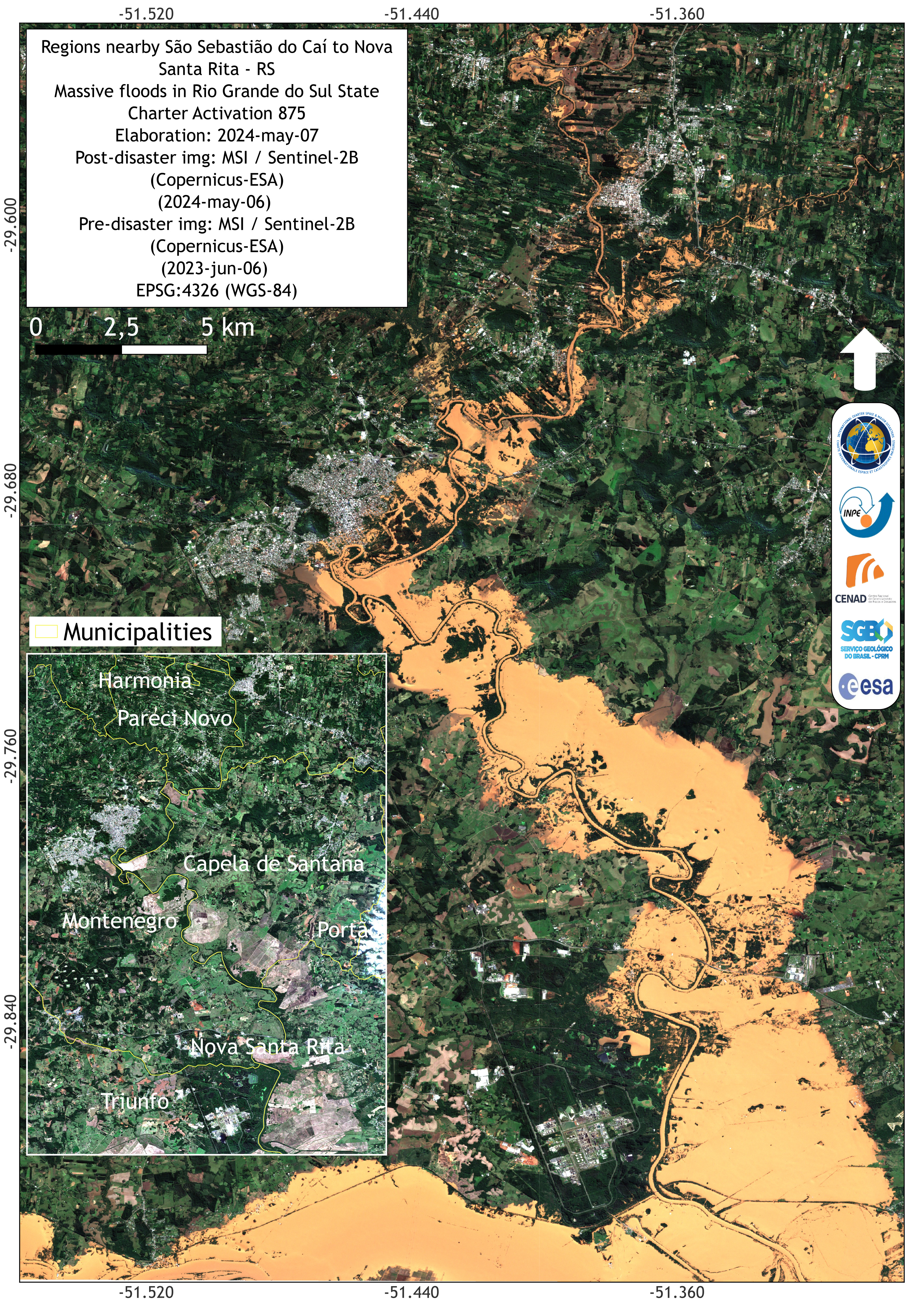
Areas Affected by the Taquari River Flood in the Municipalities of Arroio do Meio and Colinas Situation
版权: BlackSky Technology Inc. (on behalf of itself and its Affiliates, collectively "BlackSky") provides notification that its imagery and logos are trademarked and under copyrights of BlackSky. The further use and/or dissemination of this imagery and/or any product in any way derived there from are restricted without express prior written permission.
Map produced by INPE
Information about the Product
已获得: 06/05/2024
源: GLOBAL
类别: Reference Map


Flooding Event in Encantado - RS - Brazil
版权: © (2024) DigitalGlobe, Inc., Longmont CO USA 80503. DigitalGlobe and the DigitalGlobe logos are trademarks of DigitalGlobe, Inc. The use and/or dissemination of this data and/or of any product in any way derived there from are restricted. Unauthorized use and/or dissemination is prohibited.
Map produced by INPE
Information about the Product
已获得: 07/05/2024
源: WorldView
类别: Delineation Monitoring Maps
Flooding Event in Rio Grande - RS - Brazil
版权: GLOBAL © BlackSky Technology Inc. (On behalf of itself and its Affiliates, collectively "BlackSky") provides notification that its imagery and logos are trademarked and under copyrights of BlackSky. The further use and/or dissemination of this imagery and/or any product in any way derived there from are restricted without express prior written permission.
WorldView © (2024) DigitalGlobe, Inc., Longmont CO USA 80503. DigitalGlobe and the DigitalGlobe logos are trademarks of DigitalGlobe, Inc. The use and/or dissemination of this data and/or of any product in any way derived there from are restricted. Unauthorized use and/or dissemination is prohibited.
Map produced by INPE
Information about the Product
已获得: GLOBAL: 09/05/2024
WorldView: 25/04/2024
源: GLOBAL/ WorldView
类别: Delineation Monitoring Maps

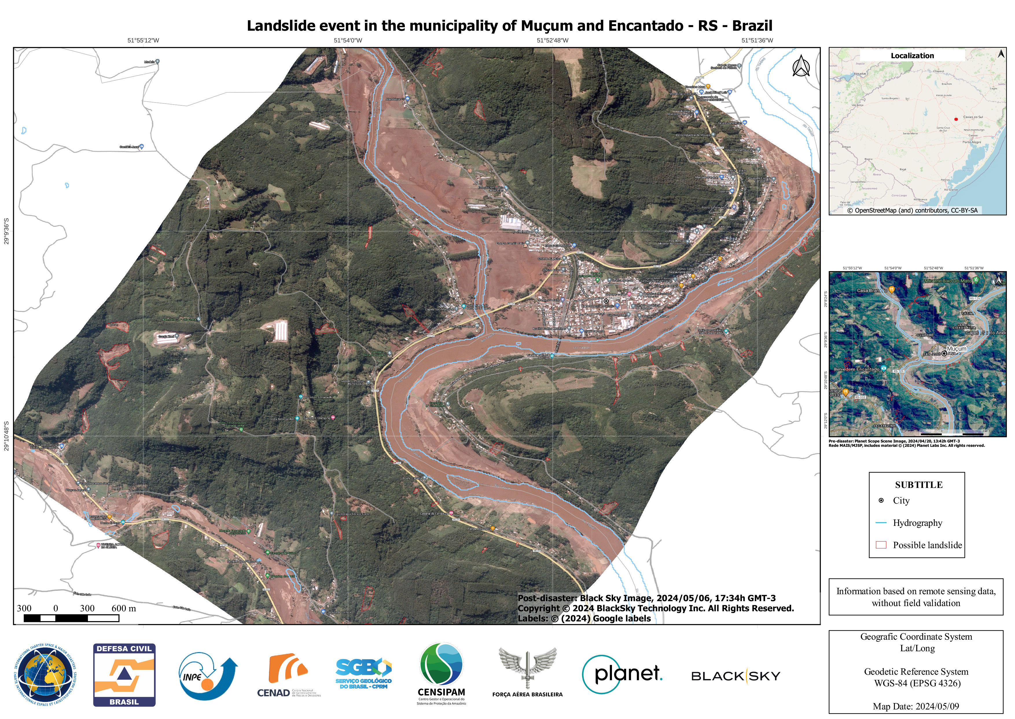
Flooding Event in Muçum- RS - Brazil
版权: © (2024) DigitalGlobe, Inc., Longmont CO USA 80503. DigitalGlobe and the DigitalGlobe logos are trademarks of DigitalGlobe, Inc. The use and/or dissemination of this data and/or of any product in any way derived there from are restricted. Unauthorized use and/or dissemination is prohibited.
Map produced by INPE
Information about the Product
已获得: 07/05/2024
源: WorldView-2
类别: Delineation Monitoring Maps
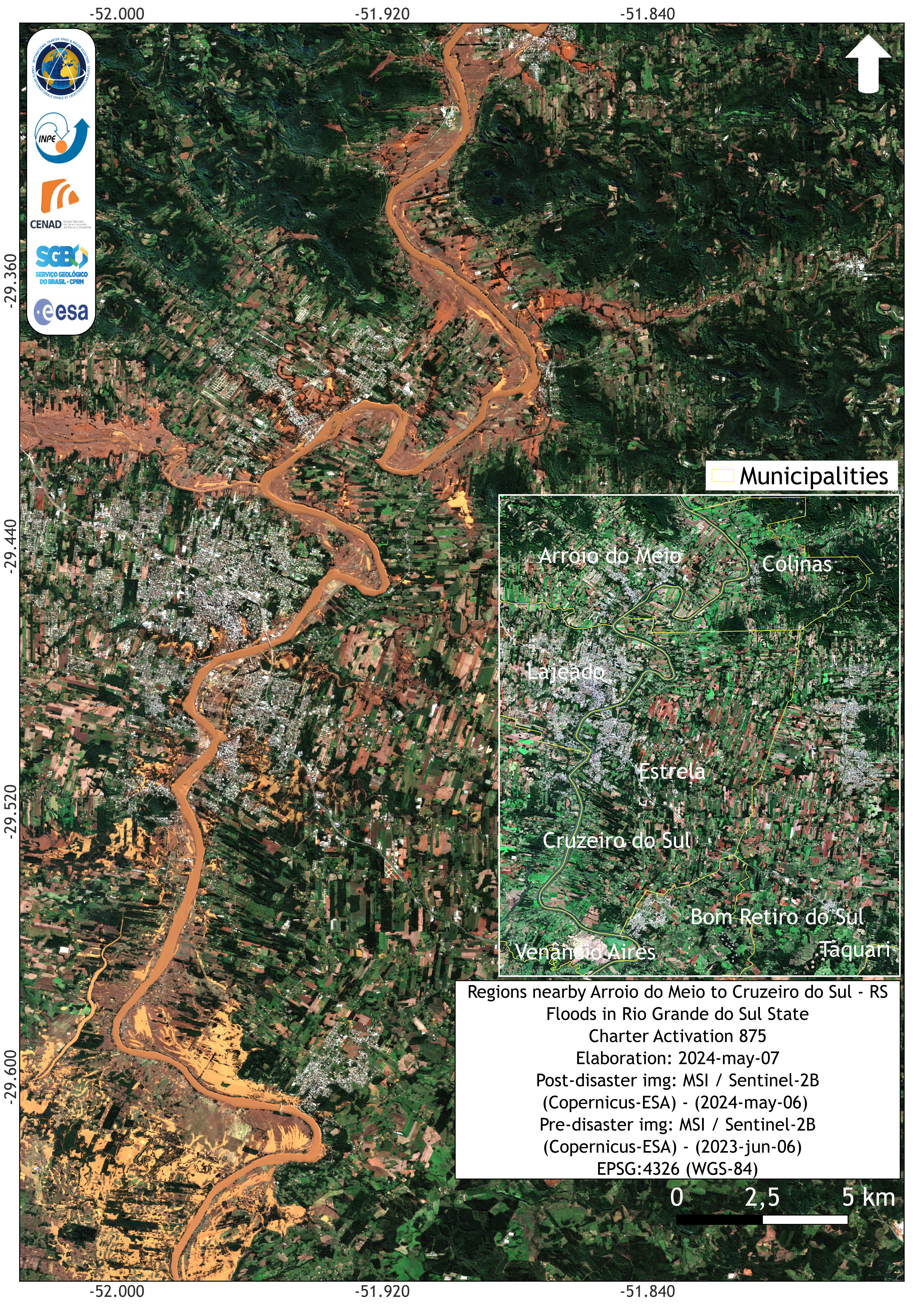
Flooding Event in Lajeado - Rio Grande do Sul - Brazil - Brazil
版权: © (2024) DigitalGlobe, Inc., Longmont CO USA 80503. DigitalGlobe and the DigitalGlobe logos are trademarks of DigitalGlobe, Inc. The use and/or dissemination of this data and/or of any product in any way derived there from are restricted. Unauthorized use and/or dissemination is prohibited.
Map produced by INPE
Information about the Product
已获得: 07/05/2024
源: WorldView
类别: Delineation Monitoring Maps


Flooding Event in Canoas - Rio Grande do Sul - Brazil
版权: © (2024) DigitalGlobe, Inc., Longmont CO USA 80503. DigitalGlobe and the DigitalGlobe logos are trademarks of DigitalGlobe, Inc. The use and/or dissemination of this data and/or of any product in any way derived there from are restricted. Unauthorized use and/or dissemination is prohibited.
Map produced by INPE
Information about the Product
已获得: 06/05/2024
源: WorldView
类别: Delineation Monitoring Maps


Areas affected by flooding in the Canhemborá and Nova Boêmia areas in Rio Grande do Sul, Brazil
版权: © (2024) DigitalGlobe, Inc., Longmont CO USA 80503. DigitalGlobe and the DigitalGlobe logos are trademarks of DigitalGlobe, Inc. The use and/or dissemination of this data and/or of any product in any way derived there from are restricted. Unauthorized use and/or dissemination is prohibited
Map produced by INPE
Information about the Product
已获得: 06/05/2024
源: WorldView-2
类别: Delineation Monitoring Maps
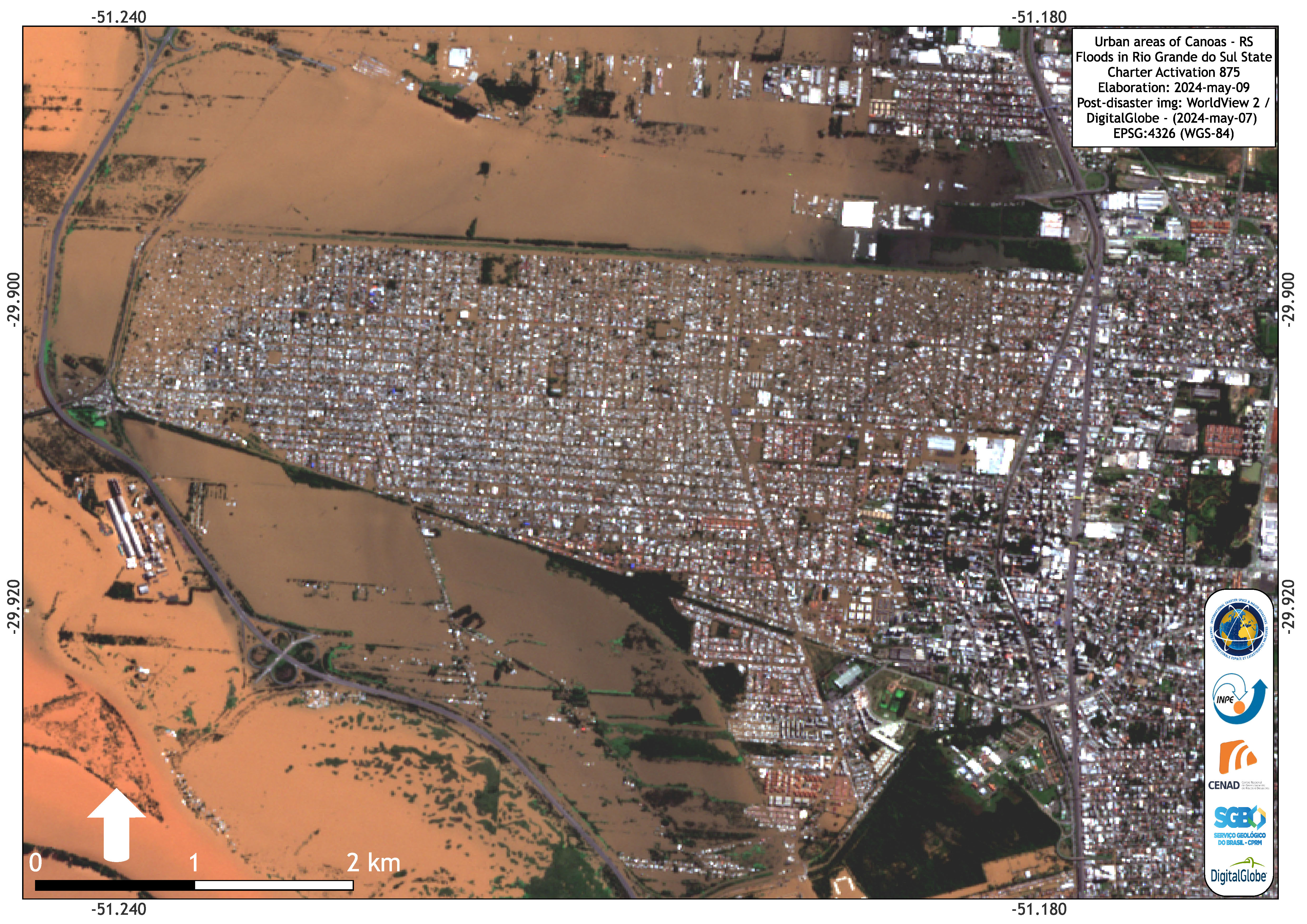
Urban areas in Canoas affected by floods
版权: © (2024) DigitalGlobe, Inc., Longmont CO USA 80503. DigitalGlobe and the DigitalGlobe logos are trademarks of DigitalGlobe, Inc. The use and/or dissemination of this data and/or of any product in any way derived there from are restricted. Unauthorized use and/or dissemination is prohibited .
Map produced by INPE
Information about the Product
已获得: 07/05/2024
源: WorldView-2
类别: Delineation Map

Areas in Canoas affected by massive floods
版权: © (2024) DigitalGlobe, Inc., Longmont CO USA 80503. DigitalGlobe and the DigitalGlobe logos are trademarks of DigitalGlobe, Inc. The use and/or dissemination of this data and/or of any product in any way derived there from are restricted. Unauthorized use and/or dissemination is prohibited
Map produced by INPE
Information about the Product
已获得: 07/05/2024
源: WorldView-2
类别: Delineation Map

Urban areas in Canoas affected by floods
版权: © (2024) DigitalGlobe, Inc., Longmont CO USA 80503. DigitalGlobe and the DigitalGlobe logos are trademarks of DigitalGlobe, Inc. The use and/or dissemination of this data and/or of any product in any way derived there from are restricted. Unauthorized use and/or dissemination is prohibited
Map produced by INPE
Information about the Product
已获得: 07/05/2024
源: WorldView-2
类别: Delineation Map

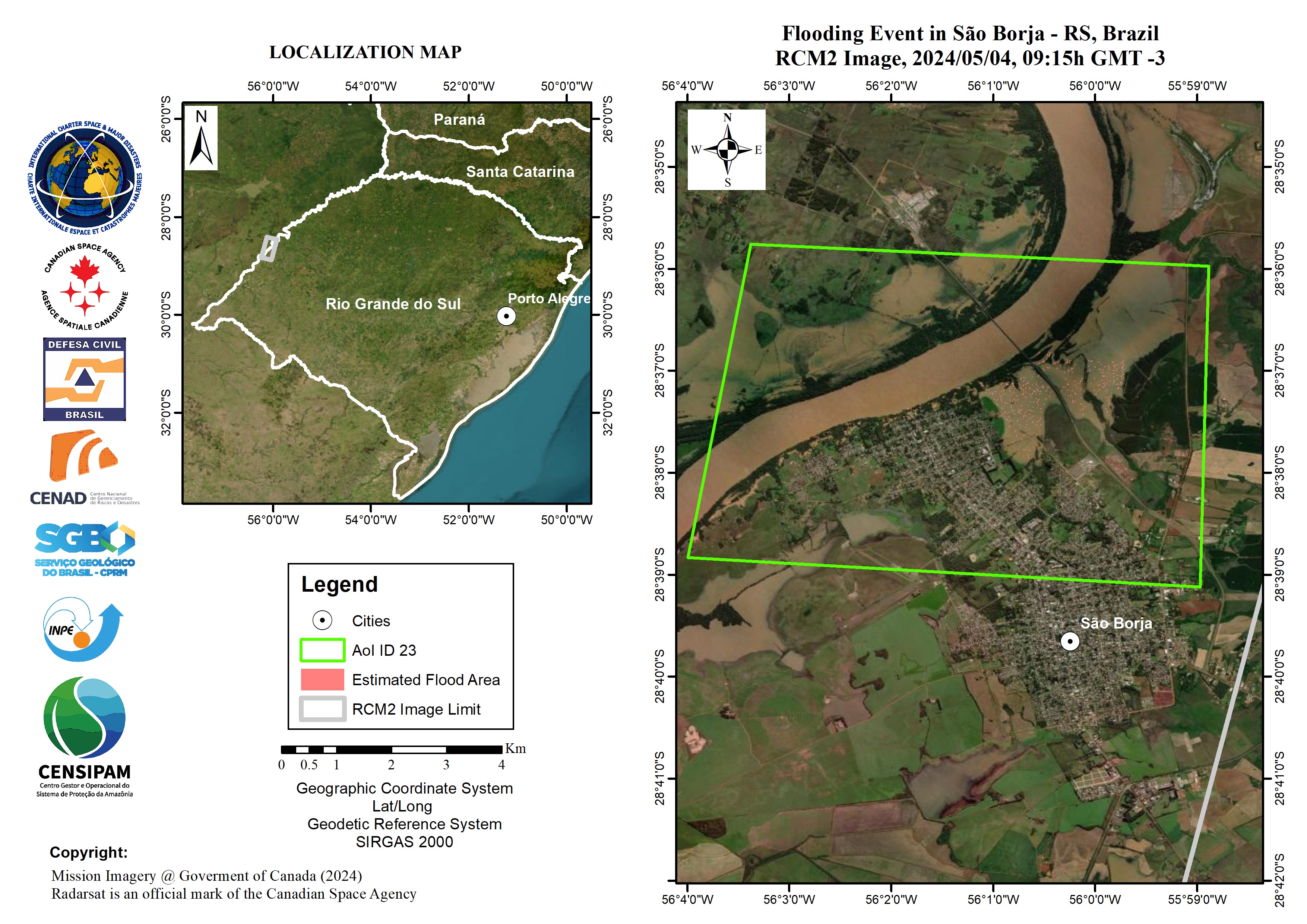
Flood in Rio Grande Do Sul State, Brazil
Download full product
版权: © ASI (Year of Acquisition). All rights reserved.
Map produced by Copernicus EMS
Information about the Product
已获得: 04/05/2024
源: COSMO-SkyMed
类别: Delineation Map


Areas affected by flooding in the Tarquari river area
版权: RADARSAT Constellation Mission Imagery © Government of Canada (2024) - RADARSAT is an official mark of the Canadian Space Agency
RADARSAT-2 Data and Products © Maxar Technologies Ltd. (2024) – All Rights Reserved
RADARSAT is an official mark of the Canadian Space Agency
Map produced by INPE
Information about the Product
已获得: RCM-2: 01/05/2024
RADARSAT2: 03/05/2024
源: RCM / RADARSAT-2
类别: Delineation Map


Areas affected by floods in Alvear and La Cruz in Argentina and in Itaqui in Rio Grande do Sul, Brazil.
版权: RADARSAT Constellation Mission Imagery © Government of Canada (2024) - RADARSAT is an official mark of the Canadian Space Agency
Map produced by INPE
Information about the Product
已获得: 06/05/2024
源: RCM
类别: Gradient Monitoring Maps


Floods between the municipalities of Porto Alegre and Canoas.
版权: BlackSky Technology Inc. (on behalf of itself and its Affiliates, collectively "BlackSky") provides notification that its imagery and logos are trademarked and under copyrights of BlackSky. The further use and/or dissemination of this imagery and/or any product in any way derived there from are restricted without express prior written permission.
Map produced by INPE
Information about the Product
已获得: 06/05/2024
源: GLOBAL
类别: Reference Map

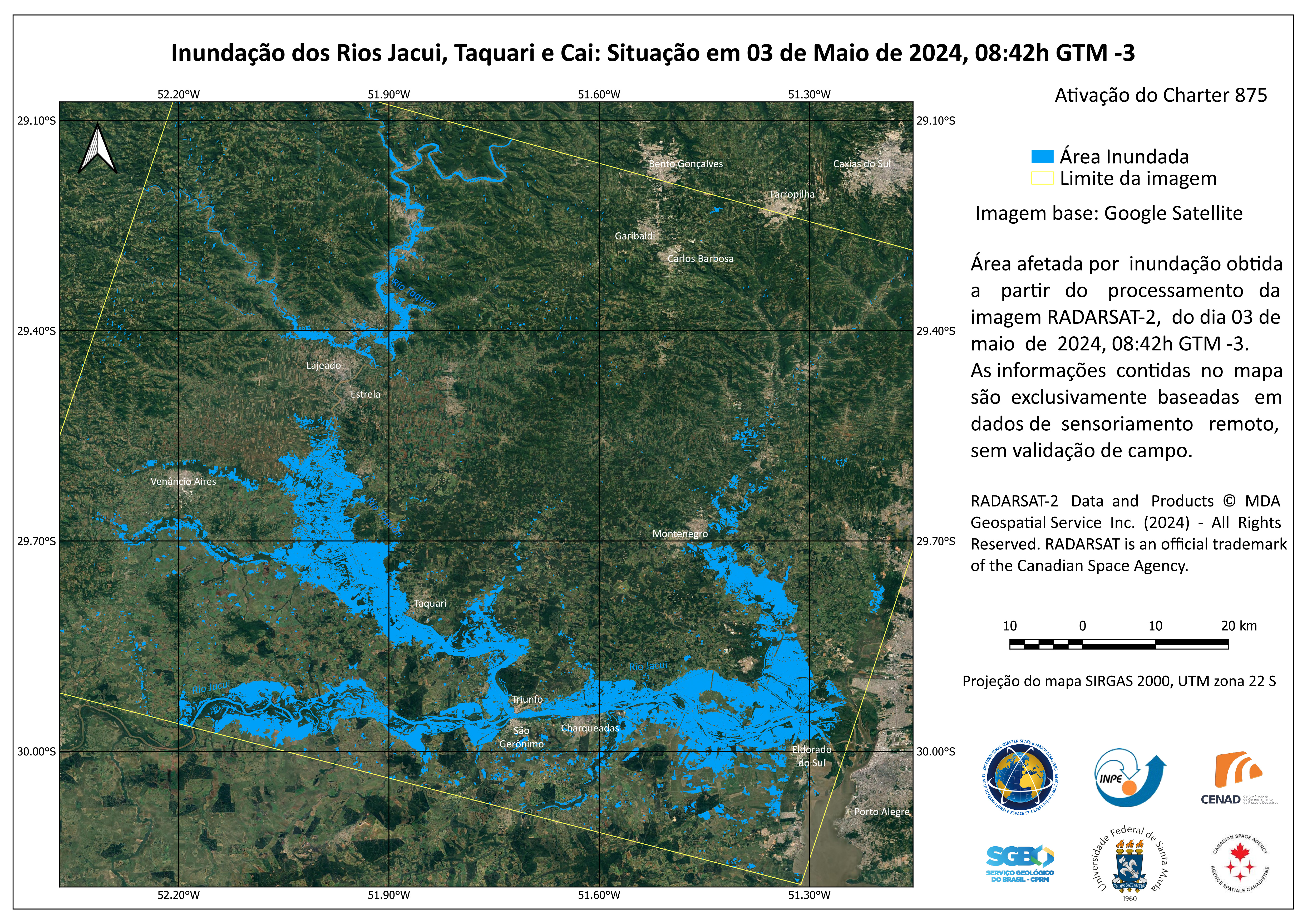
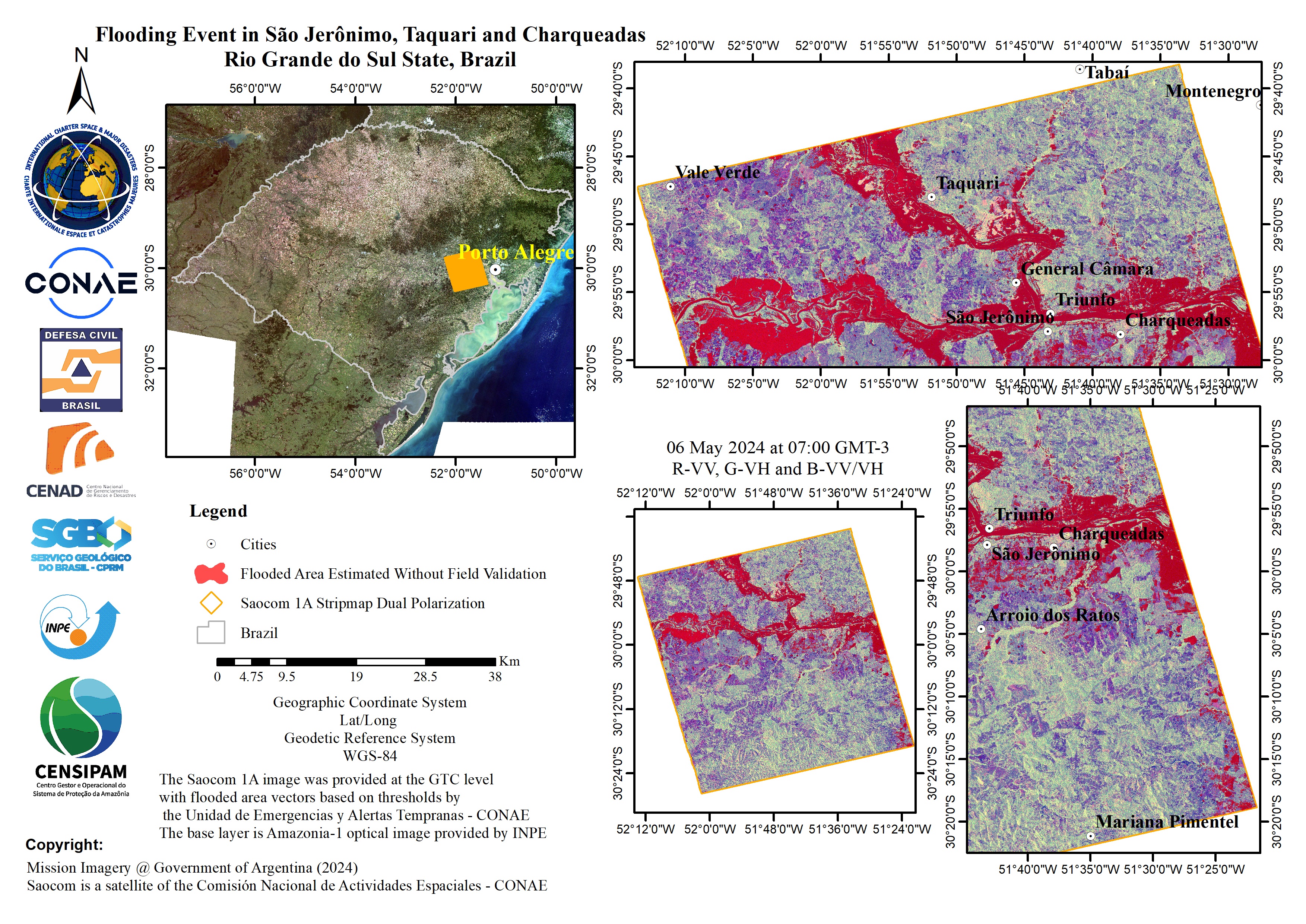
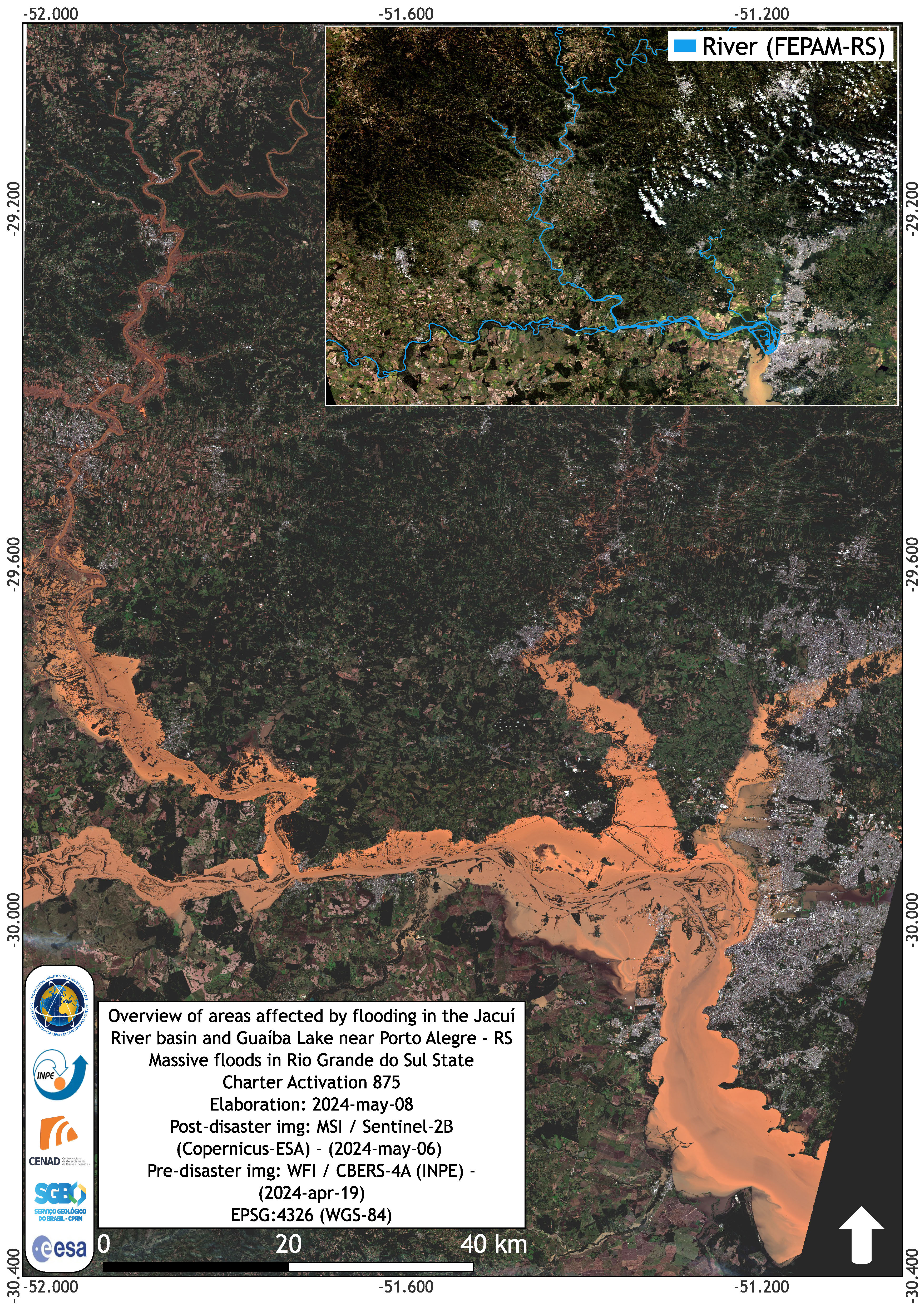
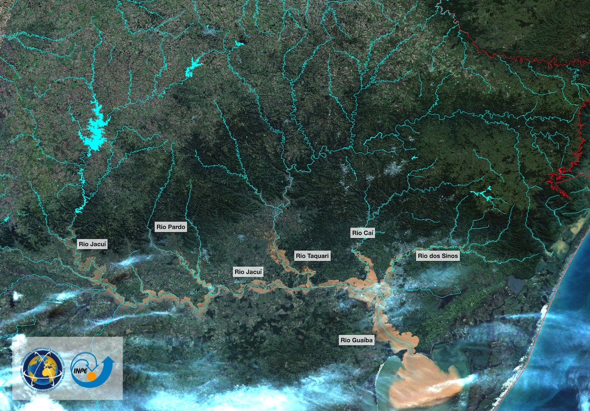
Flooding of the Jacui, Taquari and Cai Rivers, Brazil
版权: RADARSAT-2 Data and Products © Maxar Technologies Ltd. (2024) – All Rights Reserved RADARSAT is an official mark of the Canadian Space Agency
Map produced by INPE
Information about the Product
已获得: 03/05/2024
源: RADARSAT-2
类别: Delineation Map


Paso de los Libres Flood Event in Argentina and Uruguaiana in Rio Grande do Sul, Brazil.
版权: RADARSAT Constellation Mission Imagery © Government of Canada (2024) - RADARSAT is an official mark of the Canadian Space Agency
Map produced by INPE
Information about the Product
已获得: 05/05/2024
源: RCM
类别: Gradient Monitoring Maps


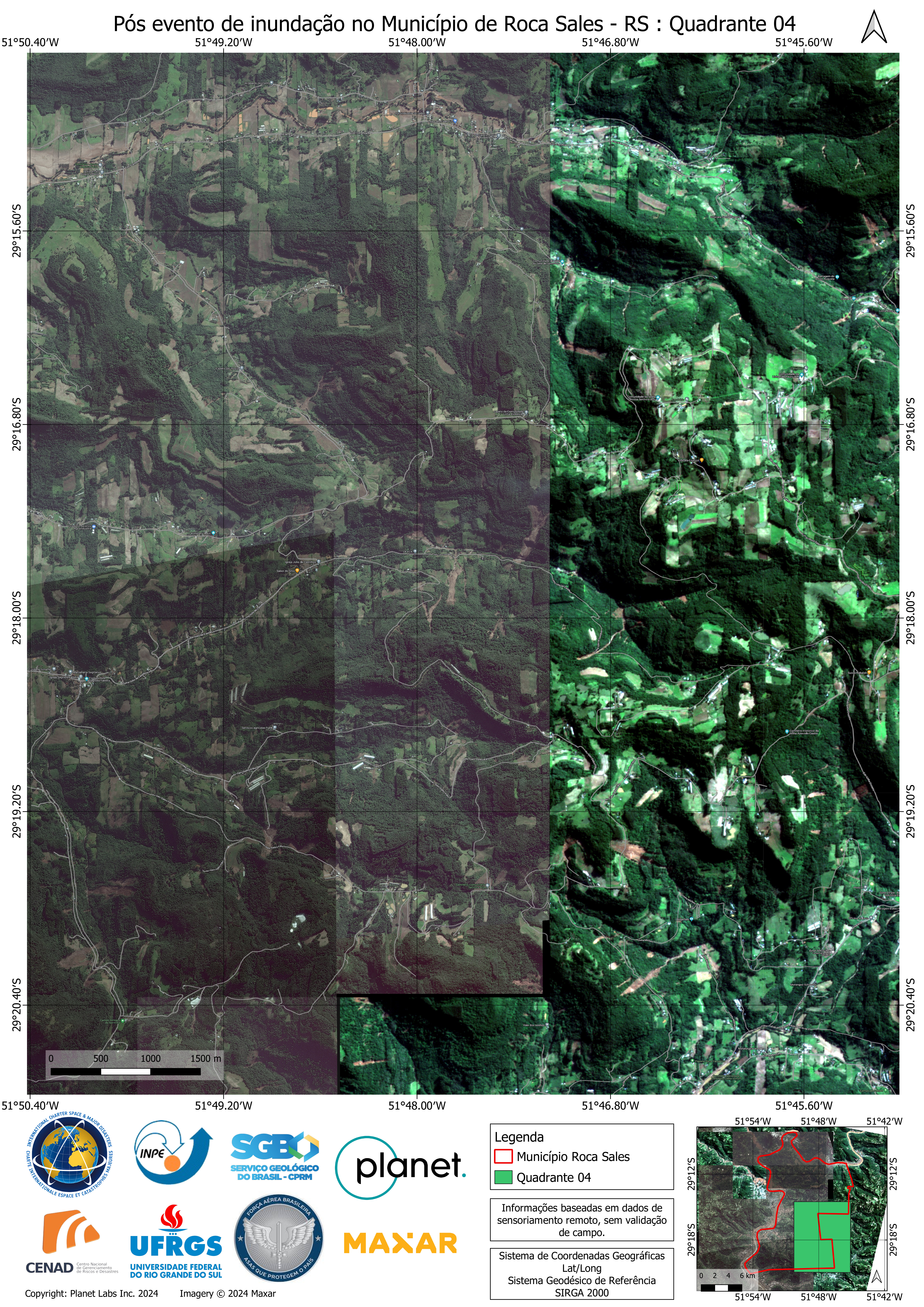
Delineation product with identification of flooded areas over Roca Sales
Download full product
版权: PAZ satellite image © Hisdesat Servicios Estratégicos S.A., 2024. Copernicus EMS (© 2024 European Union).
Map produced by Copernicus EMS
Information about the Product
已获得: 05/05/2024
源: PAZ
类别: Delineation Map


Delineation Monitoring Product with the identification of the affected areas over Encantado
版权: © Hisdesat Servicios Estratégicos S.A., 2021. All images are provided under COPERNICUS by the European Union and ESA, all rights reserved. Copernicus EMS (© 2024 European Union).
Map produced by Copernicus EMS
Information about the Product
已获得: 05/05/2024
源: PAZ
类别: Delineation Monitoring Maps

Delineation Monitoring Product with the identification of the affected areas over Guapore
版权: RADARSAT-2 Data and Products © Maxar Technologies Ltd. (2024) – All Rights ReservedRADARSAT is an official mark of the Canadian Space Agency. Copernicus EMS (© 2024 European Union).
Map produced by Copernicus EMS
Information about the Product
已获得: 04/05/2024
源: RADARSAT-2
类别: Delineation Monitoring Maps


Floods between the municipalities of Charqueadas, Triunfo and Eldorado do Sul.
版权: RADARSAT Constellation Mission Imagery © Government of Canada (2024) - RADARSAT is an official mark of the Canadian Space Agency
Map produced by INPE
Information about the Product
已获得: 02/05/2024
源: RCM
类别: Reference Map


Delineation Product with the identification of the affected areas over Santa Tereza
版权: © ASI (2024). All rights reserved. Distributed by e- GEOS S.p.A. All images are provided under COPERNICUS by the European Union and ESA, all rights reserved. Copernicus EMS (© 2024 European Union).
Map produced by Copernicus EMS
Information about the Product
已获得: 04/05/2024
源: COSMO-SkyMed
类别: Delineation Map


Delineation product with identification of flooded areas over Guapore
版权: COSMO-SkyMed SG © ASI (2024), distributed by e- GEOS S.p.A. All images are provided under COPERNICUS by the European Union and ESA, all rights reserved. Copernicus EMS (© 2024 European Union).
Map produced by Copernicus EMS
Information about the Product
已获得: 04/05/2024
源: COSMO-SkyMed
类别: Delineation Map


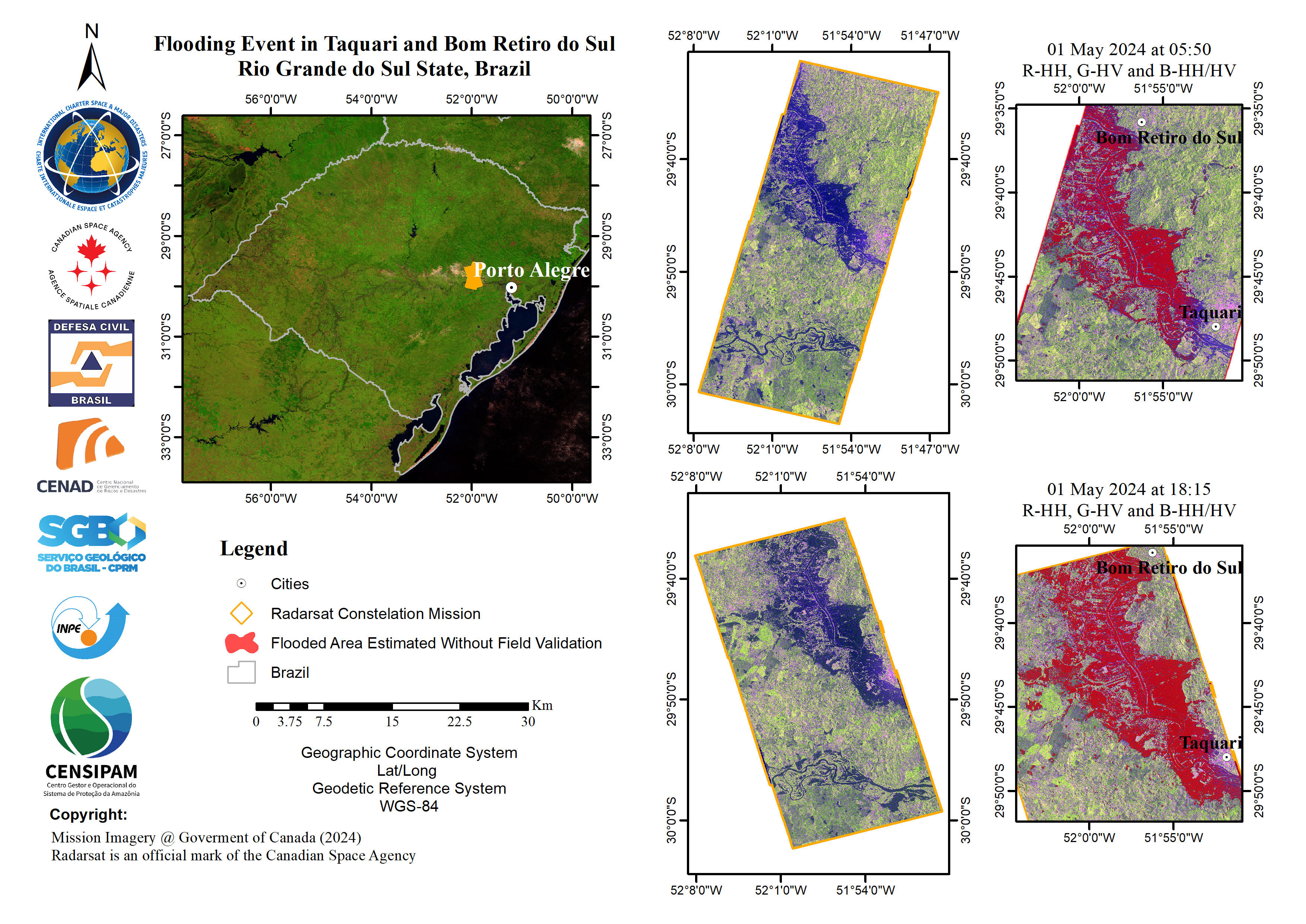
Flooding Event in Taquari and Bom Retiro do Sul, Rio Grande Sul State, Brazil
版权: RADARSAT Constellation Mission Imagery © Government of Canada (2024) - RADARSAT is an official mark of the Canadian Space Agency
Map produced by INPE
Information about the Product
已获得: 01/05/2024
源: RCM
类别: Delineation Map

Flooding Event in Marques de Souza and Bom Retiro do Sul, Rio Grande do Sul State, Brazil
版权: RADARSAT Constellation Mission Imagery © Government of Canada (2024) - RADARSAT is an official mark of the Canadian Space Agency
Map produced by INPE
Information about the Product
已获得: 01/05/2024
源: RCM
类别: Delineation Map
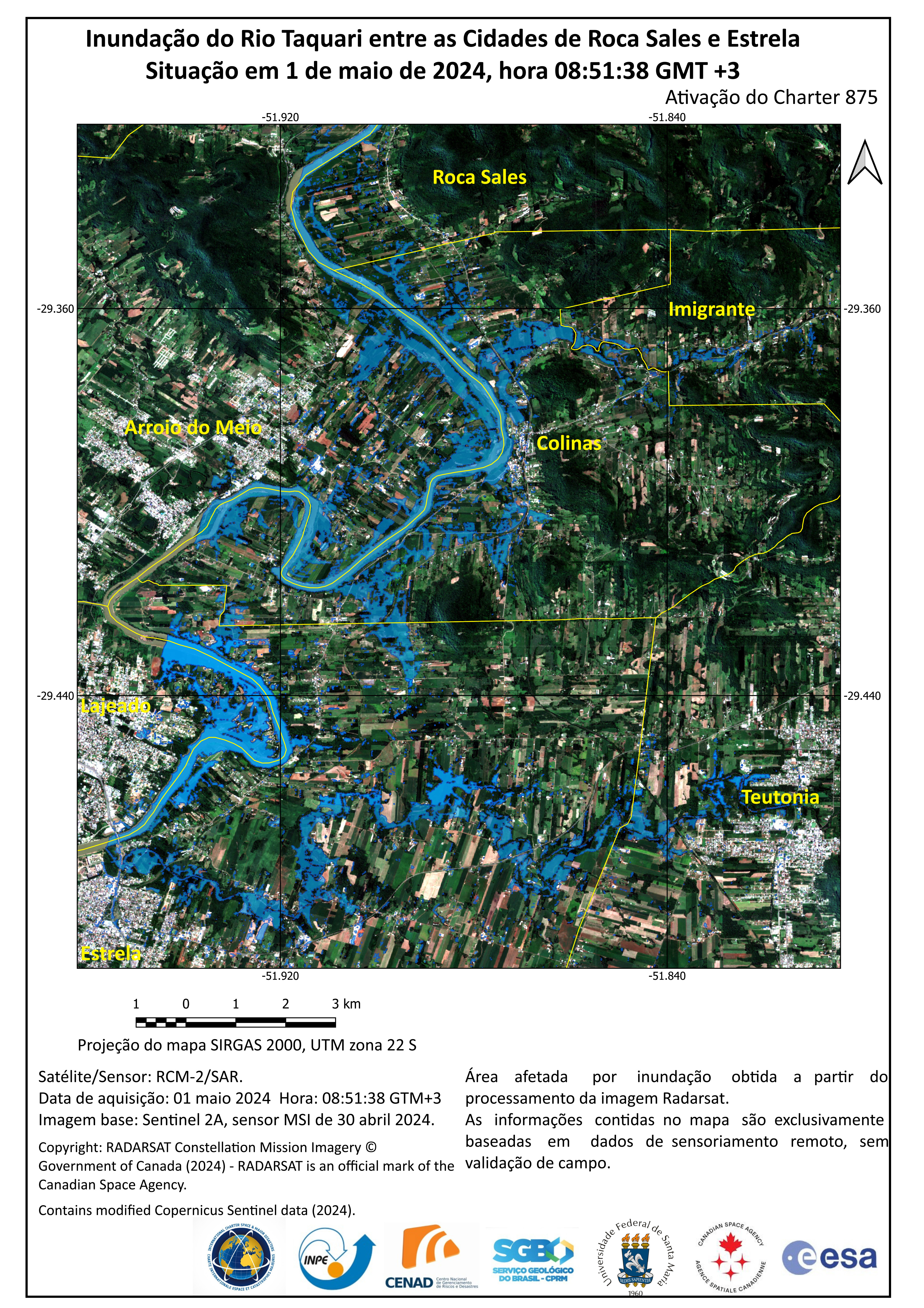
Flooding of the Taquari River between the Cities of Roca Sales and Estrela Situation
版权: RADARSAT Constellation Mission Imagery © Government of Canada (2024) - RADARSAT is an official mark of the Canadian Space Agency
Map produced by INPE
Information about the Product
已获得: 01/05/2024
源: RCM
类别: Delineation Map

Flooding of the Taquari River between the cities of Taquari and Bom Retiro do Sul Situation
版权: RADARSAT Constellation Mission Imagery © Government of Canada (2024) - RADARSAT is an official mark of the Canadian Space Agency
Map produced by INPE
Information about the Product
已获得: 01/05/2024
源: RCM
类别: Delineation Map

Taquari River - Flooded Areas Based on RCM
版权: RADARSAT Constellation Mission Imagery © Government of Canada (2024) - RADARSAT is an official mark of the Canadian Space Agency
copyright (2024) INPE
Map produced by INPE
Information about the Product
已获得: RCM-2: 01/05/2024
CBERS-4: 01/01/2024
源: RCM / CBERS-4
类别: Delineation Map
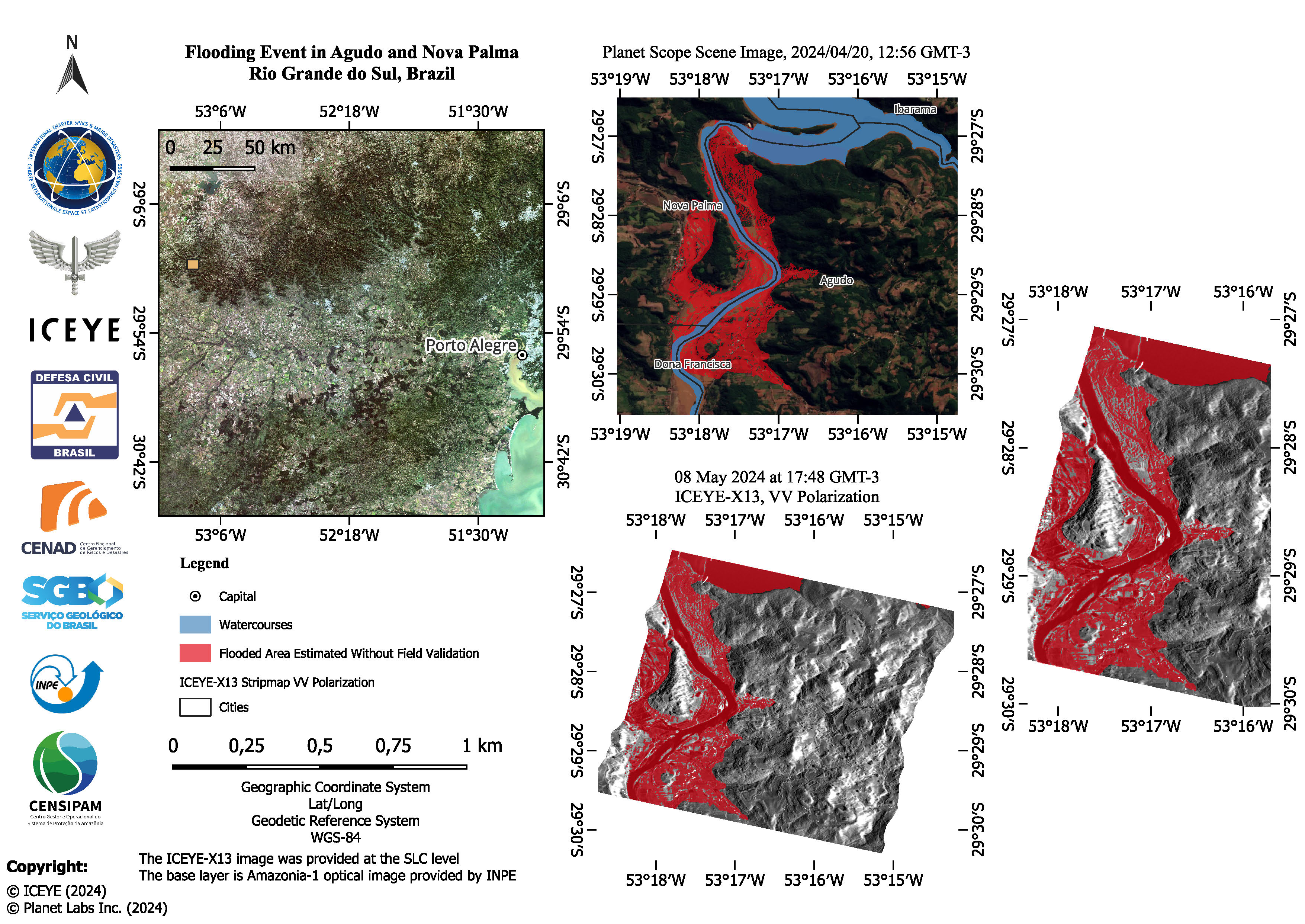
Quickviews
Quickviews are produced for illustration purposes only and do not contain any verified analysis of the disaster.

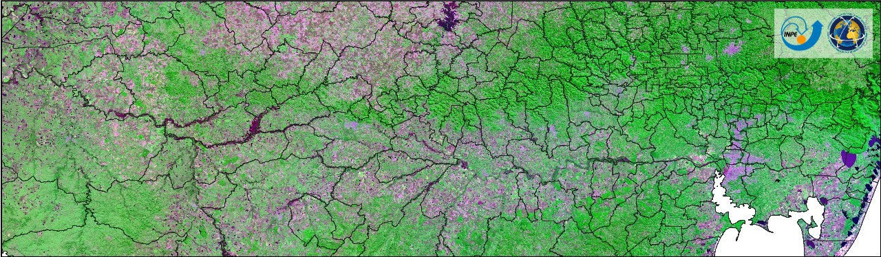
Images obtained by INPE's satellites. The pre-disaster image was obtained by Amazonia-1 on 20 April 2024, and the post-disaster image was obtained by CBERS-4 on 6 May 2024. The flooded areas appear in light brown.
Copyrights: © INPE (2024)
Information about the Quickview
Acquired: 10-04-2024 / 06-05-2024
Source(s): Amazonia-1 / CBERS-4
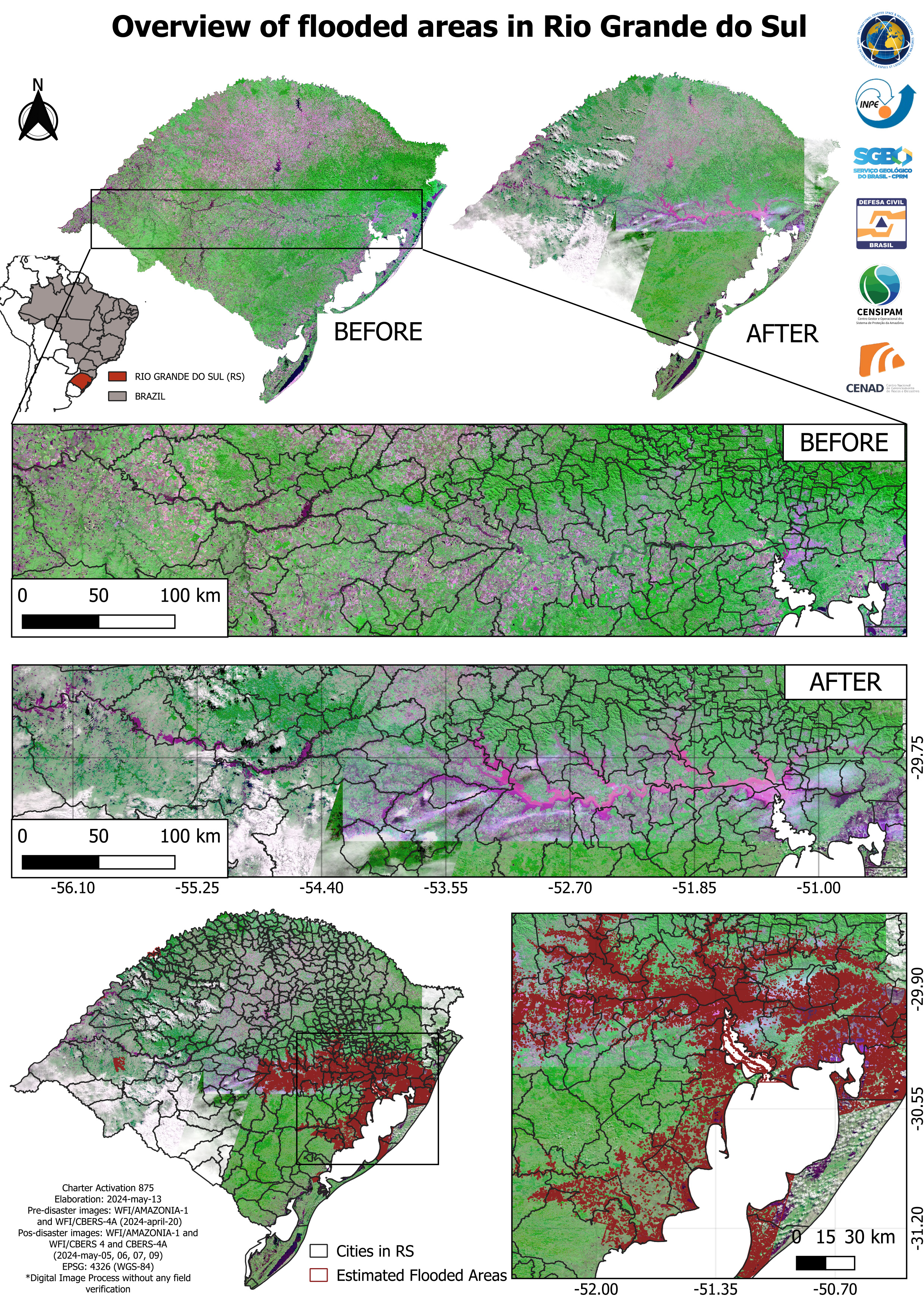
These images are from INPE satellites. The pre-disaster image was acquired by Amazonia-1 on 20 April 2024, and the post-disaster image contains a combination of CBERS-4, CBERS-4A and Amazonia-1 scenes, acquired on 5, 6, 7, and 9 May 2024.
Copyrights: © INPE (2024)
Information about the Quickview
Acquired: 20/04/2024 / 05/05/2024 to 09/05/2024
Source(s): Amazonia-1, CBERS-4 and CBERS-4A
 返回完整的响应档案
