最小化 最新宪章启动

Charter activations

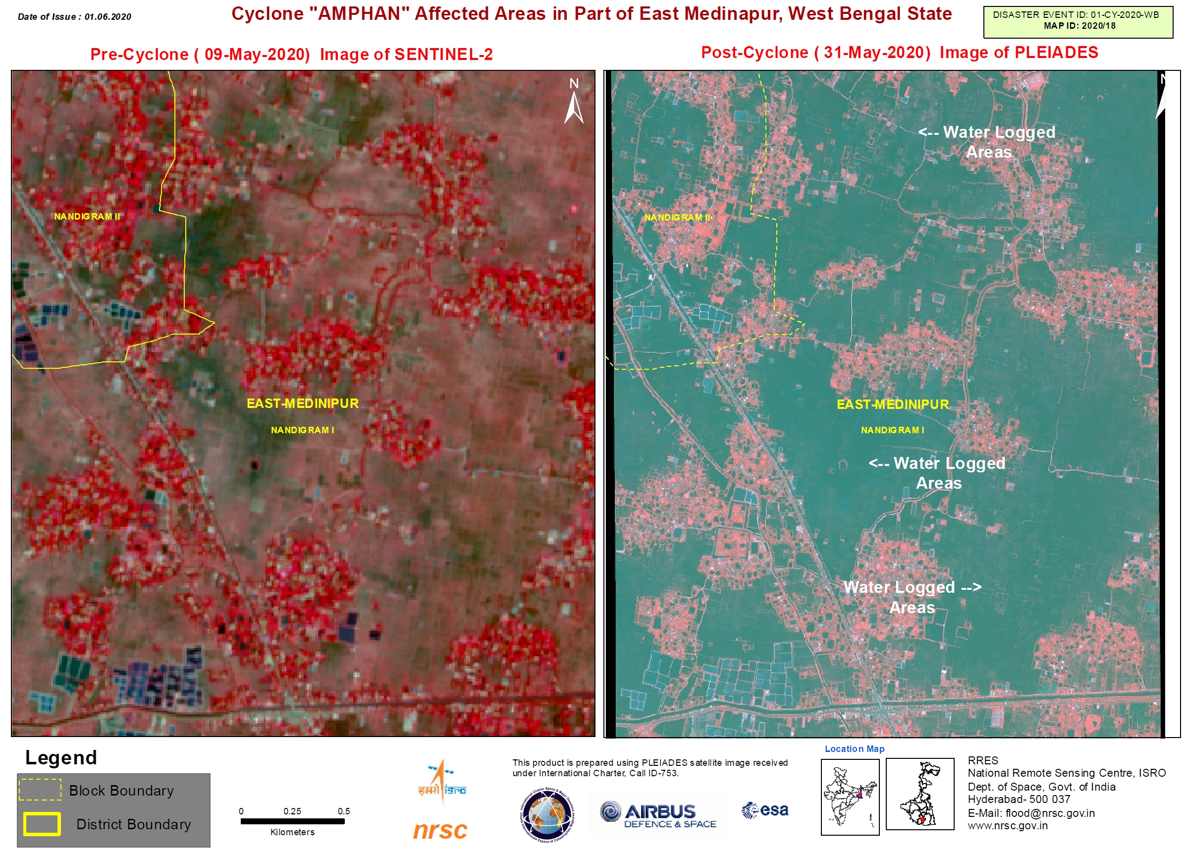
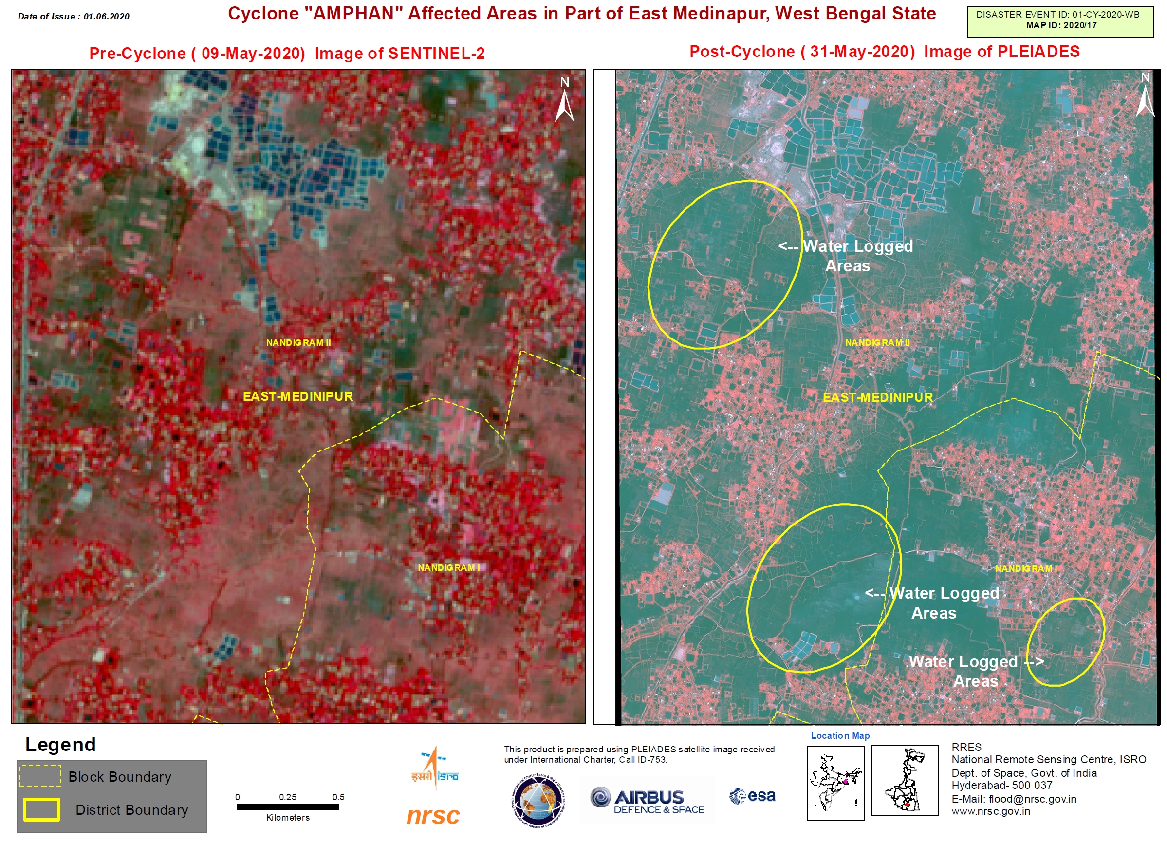
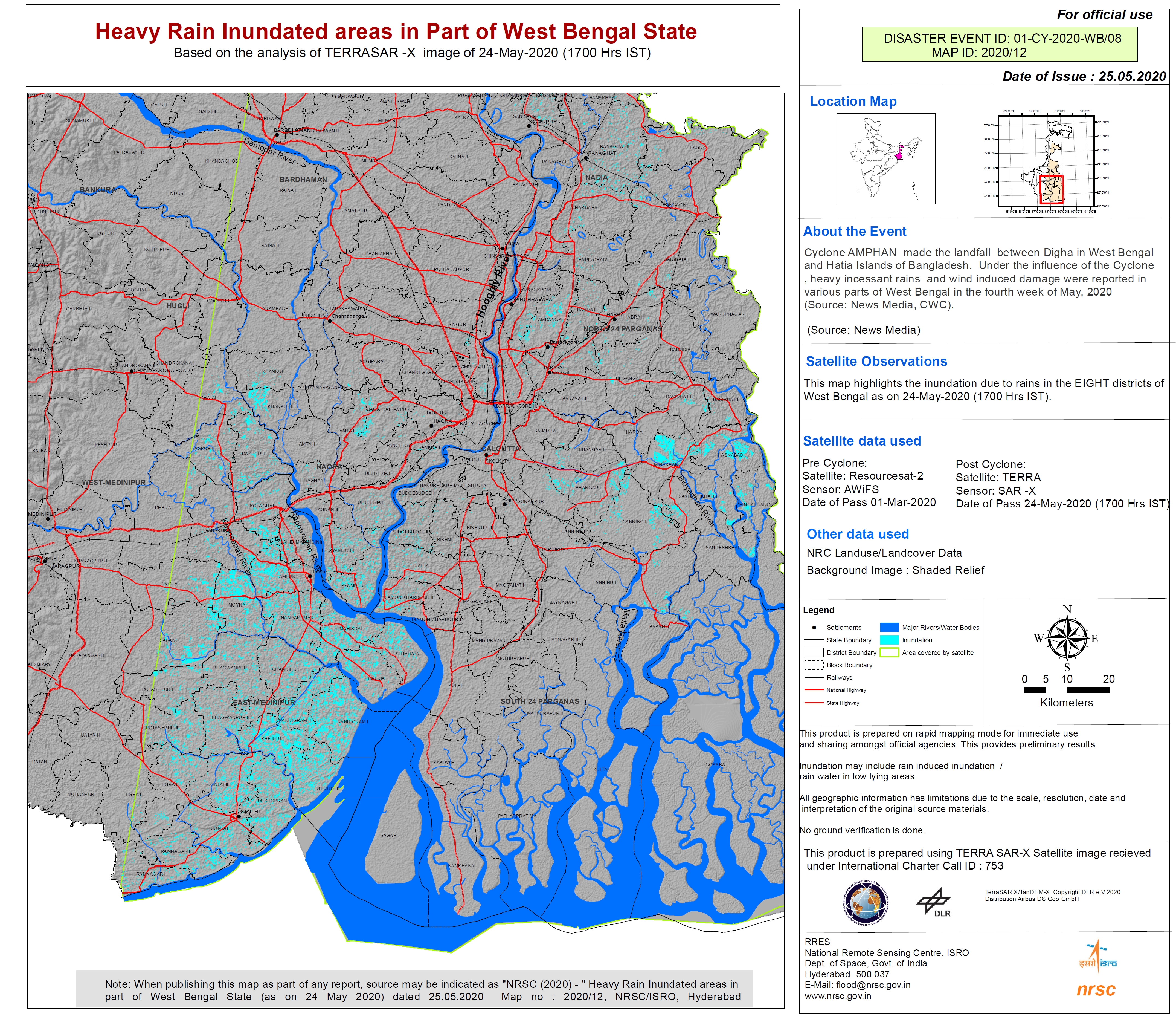
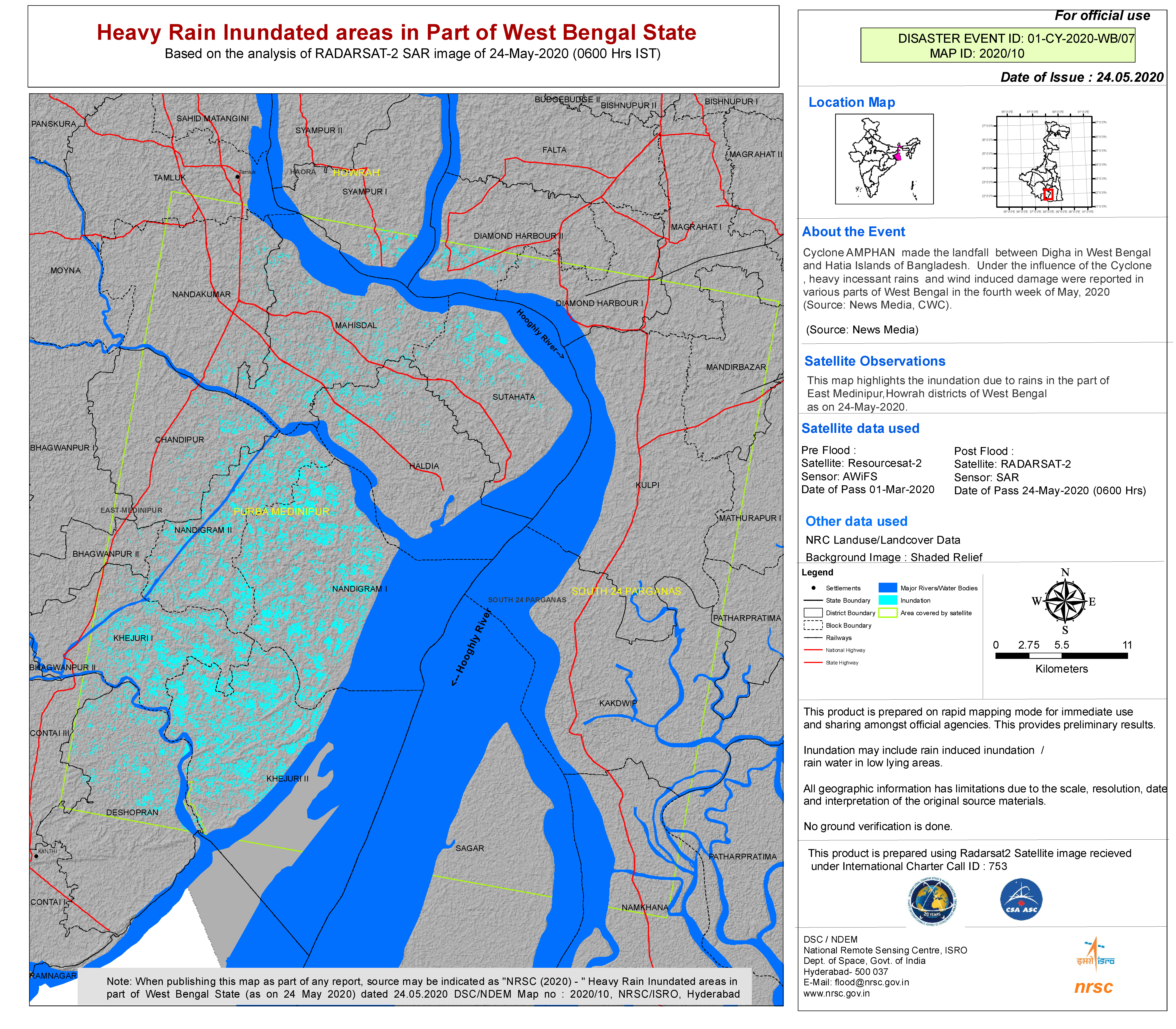
Cyclone Amphan in India

Cyclone Amphan is expected to make landfall in India on 20 May, on the coasts of India and Bangladesh between the Sagar Islands in West Bengal and the Hatiya Islands in Bangladesh.

The storm is currently Category Four on the Saffir-Simpson scale, but when it entered the Bay of Bengal on 18 May it was the strongest storm on record in the area and classified as a Super Cyclone. The storm had wind speeds of 270 kilometres per hour, but has since weakened to 200 kilometres per hour. The strong winds are expected to cause damage and the storm is forecast to bring heavy rain causing flooding. Storm surges of up to 4 metres are expected in some areas.

Officials are working to evacuate people in the affected areas (estimated to be as many as 300,000) but are finding it difficult to relocate the evacuees. Due to the Coronavirus, many in the country are under lockdown, and space in emergency shelters is limited due to distancing measures. While the shelters would normally accommodate as many as 500,000, they now may only have capacity for half that number.

Related News and Resources

事件类型:Ocean Storm - Cyclone
事件地点:India
启动宪章的日期:2020-05-19
宪章启动时间:14:58
宪章启动时区:UTC+05:30
宪章要求者:ISRO
启动ID:653
项目经理:ISRO

Products

Cyclone AMPHAN affected areas in Part of North 24 Paraganas district, West Bengal State, India

版权: Contains Copernicus Sentinel data (2020)
© Planet Labs Inc. (2020)

Information about the Product

已获得: PlanetScope: 03/06/2020
Sentinel-2: 09/05/2020

源: PlanetScope / Sentinel-2

Cyclone Amphan affected areas, Paraganas district, West Bengal State, India

版权: © Contains Copernicus Sentinel data 2020
© Planet Labs Inc. (2020)
Map produced by NRSC

Information about the Product

已获得: Sentinel-2: 09/05/2020
PlanetScope: 03/06/2020

源: Sentinel-2 / PlanetScope

Cyclone AMPHAN affected areas in Part of East Medinapur District, West Bengal State

版权: © KARI (2020)
Map produced by NRSC

Information about the Product

已获得: 31/05/2020

源: KOMPSAT-3

Cyclone AMPHAN affected areas in Part of East Medinapur District, West Bengal State, India

版权: Contains Copernicus Sentinel data 2020
© KARI (2020)
Map produced by NRSC

Information about the Product

已获得: KOMPSAT-3: 31/05/2020
Sentinel-2: 09/05/2020

源: KOMPSAT-3 / Sentinel-2

Cyclone Amphan affected areas in part of West Bengal State, India

版权: Includes Pleiades material © CNES (2020), Distribution Airbus DS.
Map produced by NRSC

Information about the Product

已获得: 31/05/2020

源: Pleiades

Cyclone Amphan affected areas in Part of East Medinapur district, West Bengal State, India

版权: Includes Pleiades material © CNES (2020), Distribution Airbus DS.
Map produced by NRSC

Information about the Product

已获得: 31/05/2020

源: Pleiades

Heavy rain inundated areas in part of West Bengal State, India

版权: KOMPSAT-5 © KARI (2020).
ResourceSat-2 data and products © ISRO (2020) - All rights reserved
Map produced by NRSC

Information about the Product

已获得: ResourceSat-2: 01/03/2020
KOMPSAT-5: 27/05/2020

源: ResourceSat-2 / KOMPSAT-5

Cyclone Amphan affected areas in part of Balasore districts, Odisha State

版权: Includes Pleiades material © CNES (2020), Distribution Airbus DS.
Map produced by NRSC

Information about the Product

已获得: 27/05/2020

源: Pleaides

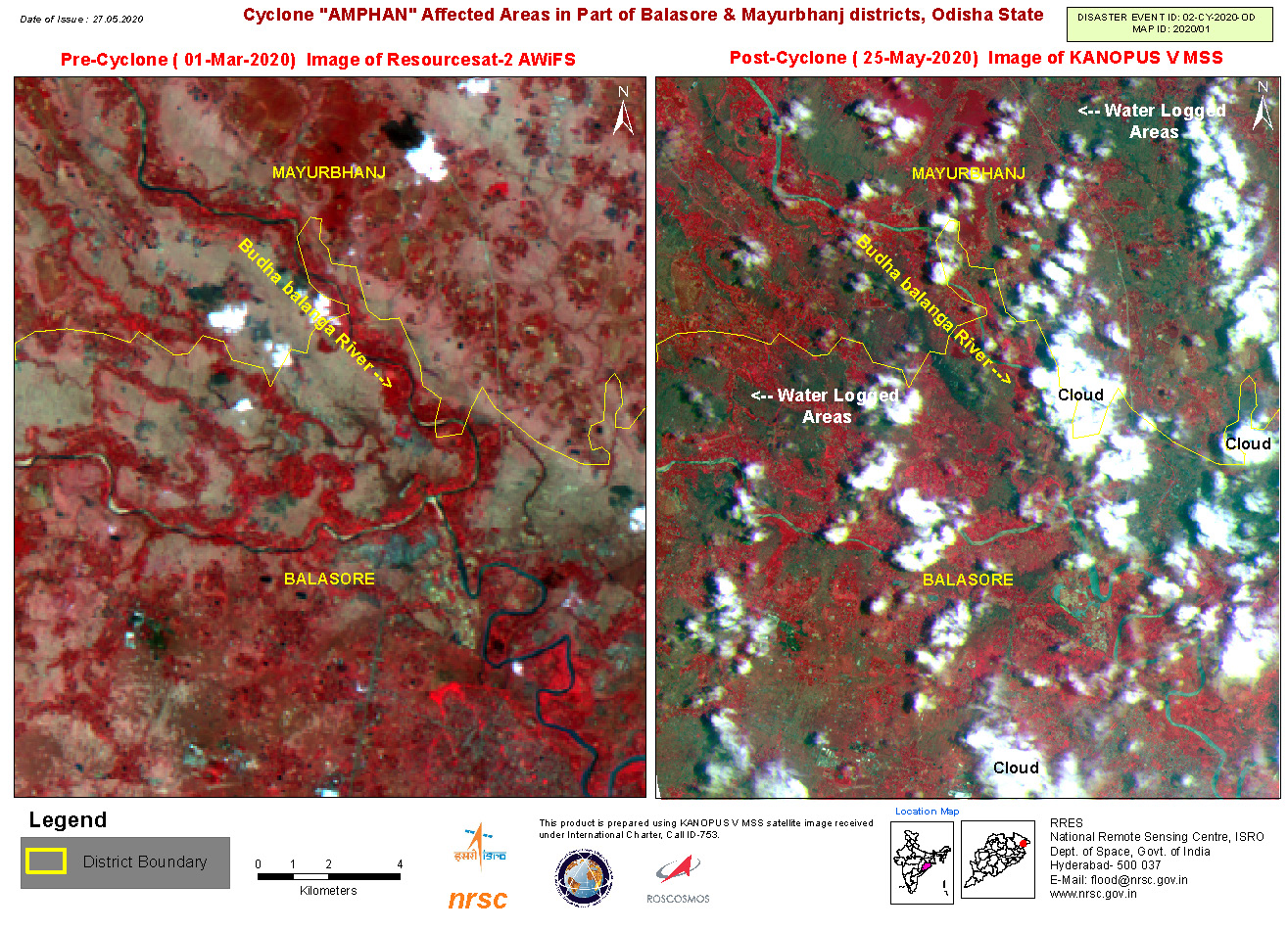
Cyclone Amphan affected areas in part of Balasore and Mayurbhanj districts, Odisha State

版权: ResourceSat-2 data and products © ISRO (2020) - All rights reserved
Kanopus-V © NTs OMZ, All Rights Reserved
Map produced by NRSC

Information about the Product

已获得: ResourceSat-2: 01/03/2020
Kanopus-V: 25/05/2020

源: ResourceSat-2 / Kanopus-V

Cyclone Amphan Affected Areas in Part of East Medinapur, West Bengal State, India

版权: Copyright (2020) INPE
Map produced by NRSC

Information about the Product

已获得: 23/05/2020

源: CBERS-4

Inundated areas in part of West Bengal State, India

版权: RADARSAT-2 Data and Products © Maxar Technologies Ltd. (2020) - All Rights Reserved. RADARSAT is an official trademark of the Canadian Space Agency.
Map produced by NRSC

Information about the Product

已获得: 25/05/2020

源: RADARSAT-2

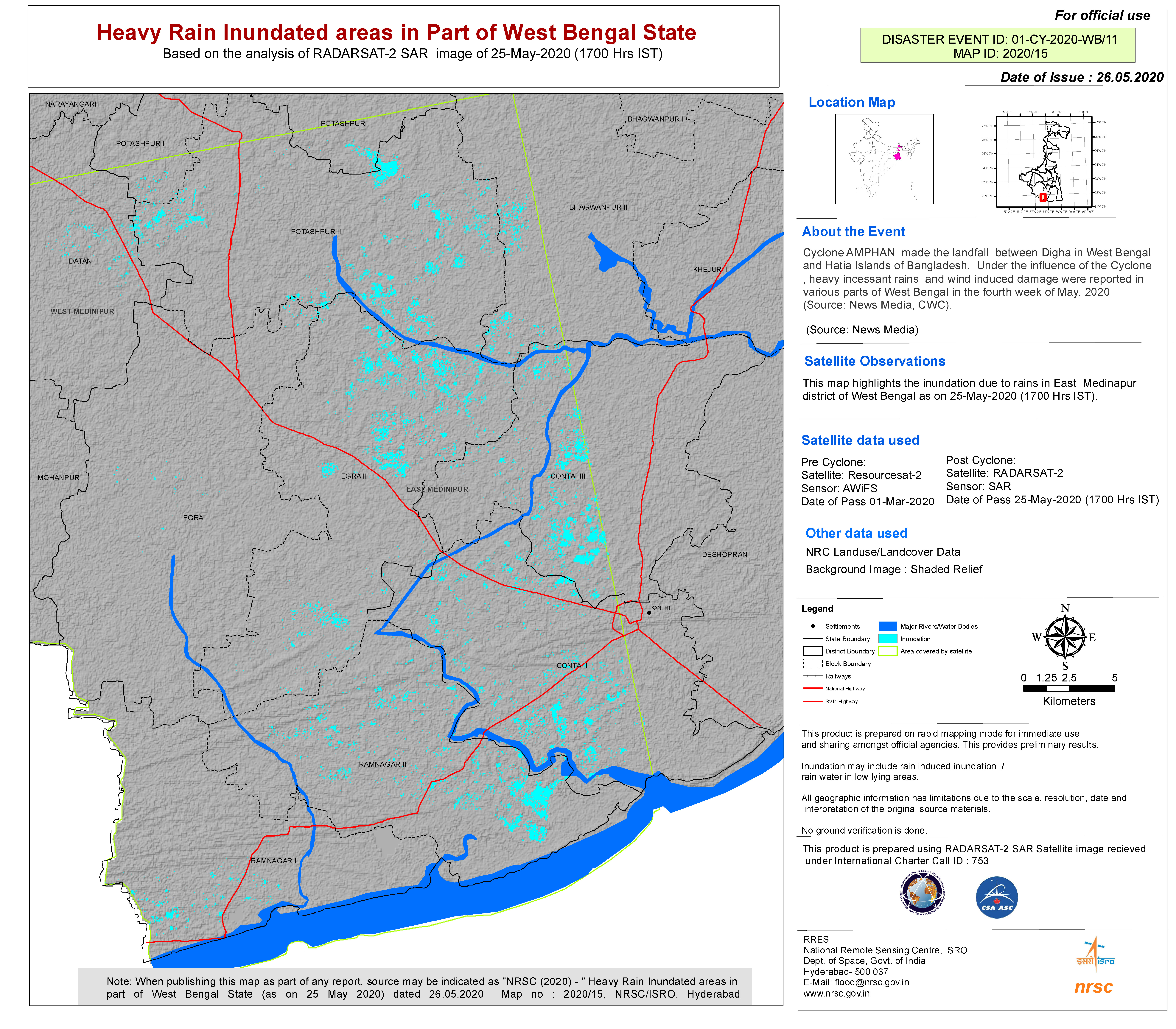
Cumulative Heavy Rain Inundated Areas in Part of West Bengal State, India

版权: © DLR e.V. (2020), Distribution Airbus DS Geo GmbH
RADARSAT-2 Data and Products © Maxar Technologies Ltd. (2020) – All Rights Reserved
Map produced by NRSC

Information about the Product

已获得: TerraSAR-X: 24/05/2020
RADARSAT-2: 24/05/2020

源: TerraSAR-X / RADARSAT-2

Heavy Rain Inundated Areas in Part of West Bengal State, India

版权: © DLR e.V. (2020), Distribution Airbus DS Geo GmbH
Map produced by NRSC

Information about the Product

已获得: 24/05/2020

源: TerraSAR-X

Heavy Rain Inundated Areas in Part of West Bengal State, India

版权: RADARSAT-2 Data and Products © Maxar Technologies Ltd. (2020) – All Rights Reserved
RADARSAT is an official mark of the Canadian Space Agency
Map produced by NRSC

Information about the Product

已获得: 24/05/2020

源: RADARSAT-2

Heavy Rain Inundated Areas in Part of West Bengal State, India

版权: RADARSAT-2 Data and Products © Maxar Technologies Ltd. (2020) – All Rights Reserved
RADARSAT is an official mark of the Canadian Space Agency
Map produced by NRSC

Information about the Product

已获得: 24/05/2020

源: RADARSAT-2

Heavy Rain Inundated Areas in Part of Odisha State, India

版权: © DLR e.V. (2020), Distribution Airbus DS Geo GmbH
Map produced by NRSC

Information about the Product

已获得: 23/05/2020

源: TerraSAR-X

返回完整的响应档案