 English
 Spanish
 French
 Chinese
 Russian
 Portuguese
 最新宪章启动
Charter activations
尼泊尔洪灾
科西河8月18号决堤,冲毁孙萨里区的七座村庄,迫使5万人转移。决堤后持续数天的恶劣天气致使洪水波及印度的比哈尔邦。据媒体报道,8月27日比哈尔邦有46人死亡。据红十会称,科西河洪水可能造成150万人受灾。
| 事件类型: | 洪水 |
| 事件地点: | 尼泊尔 |
| 启动宪章的日期: | 2008年8月29日 |
| 宪章要求者: | UNOSAT代表UN-ESCAP; UN-OCHA |
| 项目经理: | ESA |
Products

Satellite-detected flood water over South Asia, covering the eastern Indian States of Bihar and Assam and the whole of Bangladesh. Areas with likely standing flood waters have been identified from Modis Aqua and Terra satellite imagery collected from 1 to 8 September 2008. The flood water extent from August 2007 is also presented for a time comparison. Pre-flood water levels were measured for 1-10 May 2007. Of special note is the distinct area of flood water along the old Kosi river channel in the Indian state of Bihar, the result of an embankment breach in southern Nepal on 18 August 2008. Estimates of flood water area (km2) have been calculated for the affected Indian and Bangladesh administrative units (levels 1 and 2) and are presented in tabular lists. Note: only units with flooded area values over 100km2 have been included. Preliminary analysis not yet validated in the field.
版权: Credit NASA 2007, 2008
Image processing, map created 12/09/2008 by UNOSAT.
Information about the Product
已获得: 1-8/09/2008; 1-10/05/2007, 2-22/08/2007
源: MODIS Terra and Aqua, 250 m/pixel resolution.
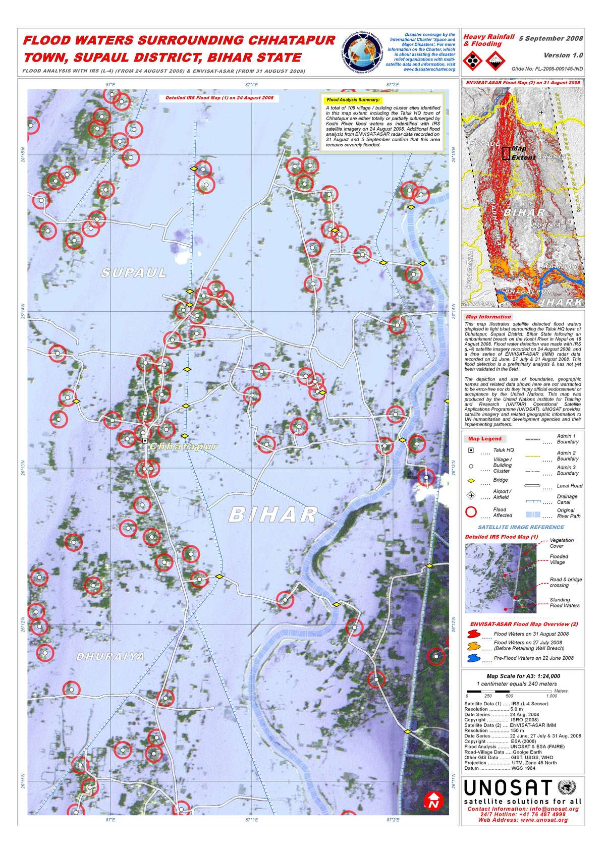
Flood waters in Chhatapur Town, Supaul District, Bihar State, 24/08/2008
版权: ESA 2008, ISRO 2008
Image processing, map created 05/09/2008 by UNOSAT.
Information about the Product
已获得: 22/06/2008, 27/07/2008, 31/08/2008 (Envisat); 24/08/2008 (IRS L-4)
A total of 108 village/building cluster sites identified in this map extent,
including the Taluk HQ town of Chhatapur are either totally or partially
submerged by Koshi River flood waters as indentified with IRS satellite
imagery on 24 August 2008. Additional flood analysis from ENVISAT-ASAR
radar data recorded on 31 August and 5 September confirm that this area
remains severely flooded.
Preliminary analysis not yet validated in the field.
源: ENVISAT-ASAR IMM and IRS L-4, 150 m/pixel (Envisat ASAR); 5.0 m/pixel (IRS L-4) resolution.

Flood Waters in Sunsari and Saptari Districts, Nepal, 31/08/2008
版权: ESA 2008, JAXA 2008
Image processing, map created 03/09/2008 by UNOSAT.
Information about the Product
已获得: 22/06/2008, 27/07/2008, 31/08/2008 (Envisat); 24/08/2008 (ALOS)
Satellite-detected flood waters on 31 August 2008 for the affected Districts of Sunsari and Saptari, Nepal following a retaining wall breach on the Koshi River on 18 August 2008. Flood water detection was made using a time series of ENVISAT-ASAR (IMM) radar data recorded on 22 June, 27 July and 31 August 2008. The length of the retaining wall breach was estimated at 1,500 meters from ALOS-PALSAR radar data acquired on 24 August 2008. Preliminary analysis not yet validated in the field.
源: ENVISAT-ASAR IMM and ALOS Palsar, 150 m/pixel (Envisat ASAR) 12.5 m/pixel (ALOS Palsar) resolution.
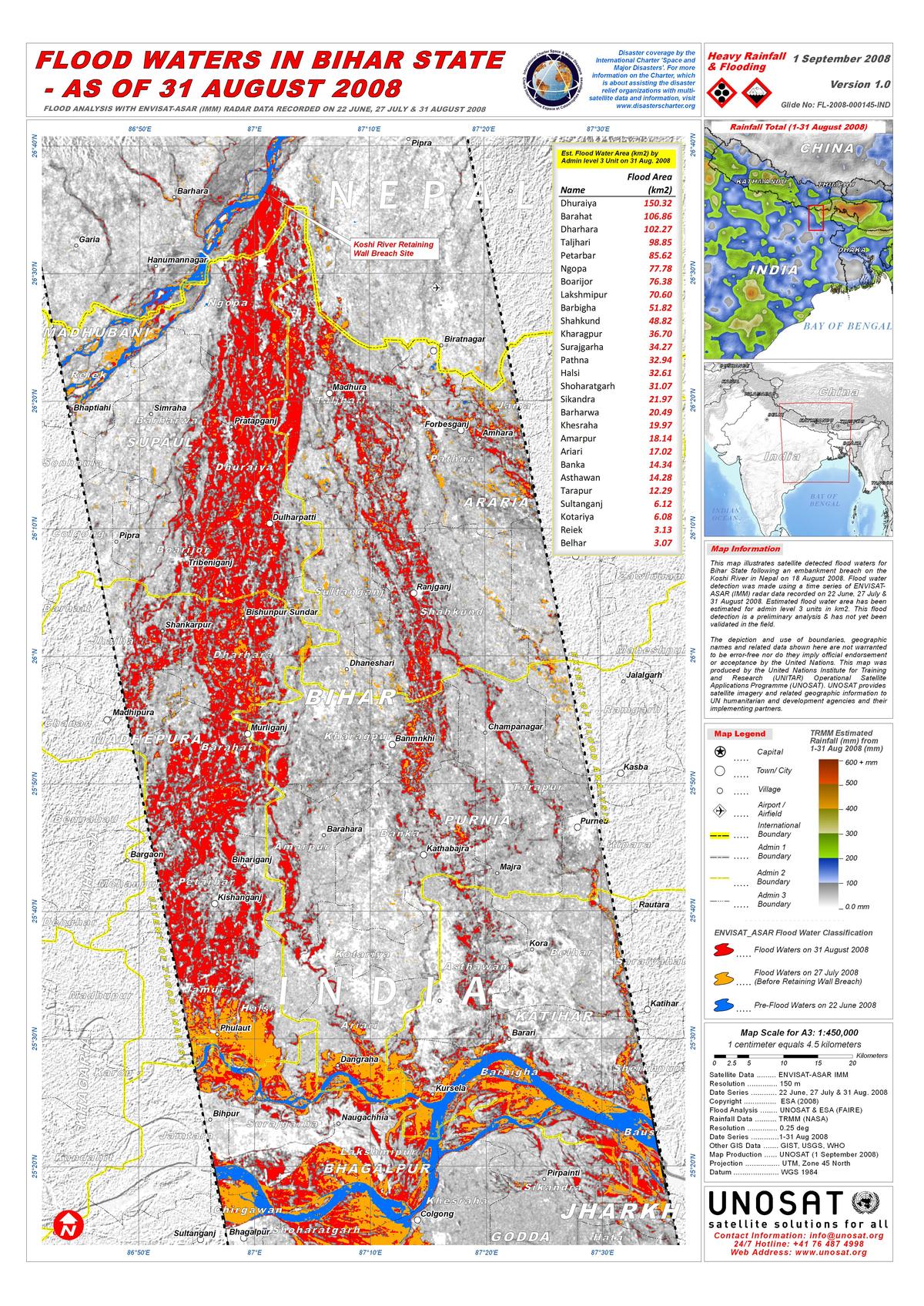
Flood waters in Bihar State, 31/08/2008
版权: ESA 2008
Image processing, map created 01/09/2008 by UNOSAT.
Information about the Product
已获得: 22/06/2008, 27/07/2008, 31/08/2008
Satellite detected flood waters for Bihar State following the embankment breach on the Koshi River in Nepal on 18 August 2008. Flood water detection was made using a time series of ENVISAT-ASAR (IMM) radar data recorded on 22 June, 27 July and 31 August 2008. Estimated flood water area has been estimated for admin level 3 units in km2. Preliminary analysis not yet verified in the field.
源: ENVISAT-ASAR IMM, 150m/pixel resolution.
 返回完整的响应档案

