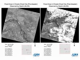
Charter activations
阿根廷洪灾
强降雨使阿根廷丘布特省、内乌肯省和里奥内格罗省的河流泛滥成灾,威胁着下游的堤坝。阿根廷国家天气服务部门2006年7月27日发出了警报。
| 事件类型: | 洪灾 |
| 事件地点: | 阿根廷乔埃莱-肖埃尔市和内乌肯市 |
| 启动宪章的日期: | 2006年7月27日 |
| 宪章要求者: | 阿根廷SIFEM |
| 项目经理: | CONAE |
Products

Radarsat 30/07/2006
版权: CSA 2006 Image processing, map created 30/07/2006 by INA (National Water Institute of Argentina). Image processing and information extraction by CONAE (Argentina Space Agency). Analysis and map creation by INA in the framework of International Charter Space and Major Disasters.
12.5m resolution
Information about the Product
已获得: 30/07/2006
源: RADARSAT-1

Spot Change Detection Choele Choel
版权: CNES 2006 Image processing, map created 04/08/2006 by INA (National Water Institute of Argentina). Image processing and information extraction by CONAE (Argentina Space Agency). Analysis and map creation by INA in the framework of International Charter Space and Major Disasters.
10m resolution
Information about the Product
已获得: 29/07/2006, 08/08/2003
源: Spot 5
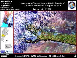
IRS-IP6 Neuquen-Rio Negro-30/07/2006
版权: ISRO 2006 Image processing, map created 06/08/2006 by INA (National Water Institute of Argentina). Image processing and information extraction by CONAE (Argentina Space Agency). Analysis and map creation by INA in the framework of International Charter Space and Major Disasters.
56m resolution
Information about the Product
已获得: 30/07/2006
源: IRS-P6 (AWIFS)

Spot/Formosat-2: General Conesa 14/08/2006 Combined scale 1:50,000
版权: CNES 2006; NSPO Taiwan 2006 Image processing, map created 23/08/2006 by INA (National Water Institute of Argentina). Image processing and information extraction by CONAE (Argentina Space Agency). Analysis and map creation by INA in the framework of International Charter Space and Major Disasters.
2m resolution
Information about the Product
已获得: 14/08/2006
源: Spot/Formosat-2

IRS-IP6 General Roca-30/07/2006
版权: ISRO 2006 Image processing, map created 06/08/2006 by INA (National Water Institute of Argentina). Image processing and information extraction by CONAE (Argentina Space Agency). Analysis and map creation by INA in the framework of International Charter Space and Major Disasters.
56m resolution
Information about the Product
已获得: 30/07/2006
源: IRS-P6 (AWIFS)

Spot/Formosat-2: 16/08/2006 scale 1:120,000 General View
版权: CNES 2006; NSPO Taiwan 2006 Image processing, map created 23/08/2006 by INA (National Water Institute of Argentina). Image processing and information extraction by CONAE (Argentina Space Agency). Analysis and map creation by INA in the framework of International Charter Space and Major Disasters.
2m resolution
Information about the Product
已获得: 16/08/2006
源: Spot/Formosat-2

Spot/Formosat-2: 16/08/2006 Downstream Detail
版权: CNES 2006; NSPO Taiwan 2006 Image processing, map created 23/08/2006 by INA (National Water Institute of Argentina). Image processing and information extraction by CONAE (Argentina Space Agency). Analysis and map creation by INA in the framework of International Charter Space and Major Disasters.
2m resolution
Information about the Product
已获得: 16/08/2006
源: Spot/Formosat-2

IRS-IP6 Choele Choel 30/07/2006
版权: ISRO 2006 Image processing, map created 06/08/2006 by INA (National Water Institute of Argentina). Image processing and information extraction by CONAE (Argentina Space Agency). Analysis and map creation by INA in the framework of International Charter Space and Major Disasters.
56m resolution
Information about the Product
已获得: 30/07/2006
源: IRS-P6 (AWIFS)

RADARSAT SPOT-5 Merged, 12.5m, 2.5m resolution
版权: CSA 2006
CNES 2006
Image processing, map created 30/07/2006 by INA (National Water Institute of Argentina).
Image processing and information extraction by CONAE (Argentina Space Agency).
Analysis and map creation by INA in the framework of International Charter Space and Major Disasters.
12.5m, 2.5m resolution
Information about the Product
已获得: 30/07/2006
源: RADARSAT-1, SPOT-5

Spot/Formosat-2: 16/08/2006 Upstream Detail
版权: CNES 2006; NSPO Taiwan 2006 Image processing, map created 23/08/2006 by INA (National Water Institute of Argentina). Image processing and information extraction by CONAE (Argentina Space Agency). Analysis and map creation by INA in the framework of International Charter Space and Major Disasters.
2m resolution
Information about the Product
已获得: 16/08/2006
源: Spot/Formosat-2

Spot/Formosat-2: 16/08/2006 Shoreline Detail
版权: CNES 2006; NSPO Taiwan 2006 Image processing, map created 23/08/2006 by INA (National Water Institute of Argentina). Image processing and information extraction by CONAE (Argentina Space Agency). Analysis and map creation by INA in the framework of International Charter Space and Major Disasters
2m resolution
Information about the Product
已获得: 16/08/2006
源: Spot/Formosat-2
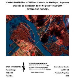
Spot/Formosat-2: 16/08/2006 Bridge Detail
版权: CNES 2006; NSPO Taiwan 2006 Image processing, map created 23/08/2006 by INA (National Water Institute of Argentina). Image processing and information extraction by CONAE (Argentina Space Agency). Analysis and map creation by INA in the framework of International Charter Space and Major Disasters.
2m resolution
Information about the Product
已获得: 16/08/2006
源: Spot/Formosat-2

Spot/Formosat-2: General Conesa 16/08/2006 Combined scale 1:50,000
版权: CNES 2006; NSPO Taiwan 2006 Image processing, map created 23/08/2006 by INA (National Water Institute of Argentina). Image processing and information extraction by CONAE (Argentina Space Agency). Analysis and map creation by INA in the framework of International Charter Space and Major Disasters.
2m resolution
Information about the Product
已获得: 16/08/2006
源: Spot/Formosat-2

Spot/Formosat-2: General Conesa 16/08/2006 Overview
版权: CNES 2006; NSPO Taiwan 2006 Image processing, map created 23/08/2006 by INA (National Water Institute of Argentina). Image processing and information extraction by CONAE (Argentina Space Agency). Analysis and map creation by INA in the framework of International Charter Space and Major Disasters.
2m resolution
Information about the Product
已获得: 16/08/2006
源: Spot/Formosat-2

Rio Negro Spot/Formosat-2: 14/08/2006 scale 1:15,000
版权: CNES 2006; NSPO Taiwan 2006 Image processing, map created 23/08/2006 by INA (National Water Institute of Argentina). Image processing and information extraction by CONAE (Argentina Space Agency). Analysis and map creation by INA in the framework of International Charter Space and Major Disasters.
2m resolution
Information about the Product
已获得: 14/08/2006
源: Spot/Formosat-2

Rio Negro Spot/Formosat-2: 14/08/2006 scale 1:50,000
版权: CNES 2006; NSPO Taiwan 2006 Image processing, map created 23/08/2006 by INA (National Water Institute of Argentina). Image processing and information extraction by CONAE (Argentina Space Agency). Analysis and map creation by INA in the framework of International Charter Space and Major Disasters.
2m resolution
Information about the Product
已获得: 14/08/2006
源: Spot/Formosat-2
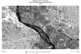
Spot/Formosat-2: Rio Neuquen 01/08/2006 scale 1:25,000
版权: CNES 2006; NSPO Taiwan 2006 Image processing, map created 04/08/2006 by INA (National Water Institute of Argentina). Image processing and information extraction by CONAE (Argentina Space Agency). Analysis and map creation by INA in the framework of International Charter Space and Major Disasters.
2m resolution
Information about the Product
已获得: 01/08/2006
源: Spot/Formosat-2

Spot/Formosat-2: Choele Choel 01/08/2006 Panchromatic image scale 1:10,000
版权: CNES 2006; NSPO Taiwan 2006 Image processing, map created 04/08/2006 by INA (National Water Institute of Argentina). Image processing and information extraction by CONAE (Argentina Space Agency). Analysis and map creation by INA in the framework of International Charter Space and Major Disasters.
2m resolution
Information about the Product
已获得: 01/08/2006
源: Spot/Formosat-2

Spot/Formosat-2: Choele Choel 01/08/2006 scale 1:125,000
版权: CNES 2006; NSPO Taiwan 2006 Image processing, map created 04/08/2006 by INA (National Water Institute of Argentina). Image processing and information extraction by CONAE (Argentina Space Agency). Analysis and map creation by INA in the framework of International Charter Space and Major Disasters.
10m resolution
Information about the Product
已获得: 01/08/2006
源: Spot/Formosat-2

Spot/Formosat-2: Neuquen-Cipolletti 01/08/2006 scale 1:125,000
版权: CNES 2006; NSPO Taiwan 2006 Image processing, map created 04/08/2006 by INA (National Water Institute of Argentina). Image processing and information extraction by CONAE (Argentina Space Agency). Analysis and map creation by INA in the framework of International Charter Space and Major Disasters.
2m resolution
Information about the Product
已获得: 01/08/2006
源: Spot/Formosat-2

Spot/Formosat-2: Choele Choel 01/08/2006 scale 1:25,000
版权: CNES 2006; NSPO Taiwan 2006 Image processing, map created 04/08/2006 by INA (National Water Institute of Argentina). Image processing and information extraction by CONAE (Argentina Space Agency). Analysis and map creation by INA in the framework of International Charter Space and Major Disasters.
10m resolution
Information about the Product
已获得: 01/08/2006
源: Spot/Formosat-2

Spot/Formosat-2: Confluence 01/08/2006 Panchromatic image scale 1:25,000
版权: CNES 2006; NSPO Taiwan 2006 Image processing, map created 04/08/2006 by INA (National Water Institute of Argentina). Image processing and information extraction by CONAE (Argentina Space Agency). Analysis and map creation by INA in the framework of International Charter Space and Major Disasters.
2m resolution
Information about the Product
已获得: 01/08/2006
源: Spot/Formosat-2

Spot/Formosat-2: Neuquen-Cipolletti 01/08/2006 scale 1:75,000
版权: CNES 2006; NSPO Taiwan 2006 Image processing, map created 04/08/2006 by INA (National Water Institute of Argentina). Image processing and information extraction by CONAE (Argentina Space Agency). Analysis and map creation by INA in the framework of International Charter Space and Major Disasters.
2m resolution
Information about the Product
已获得: 01/08/2006
源: Spot/Formosat-2

Spot/Formosat-2: Neuquen Limay River 01/08/2006 Panchromatic image scale 1:25,000
版权: CNES 2006; NSPO Taiwan 2006 Image processing, map created 04/08/2006 by INA (National Water Institute of Argentina). Image processing and information extraction by CONAE (Argentina Space Agency). Analysis and map creation by INA in the framework of International Charter Space and Major Disasters.
2m resolution
Information about the Product
已获得: 01/08/2006
源: Spot/Formosat-2
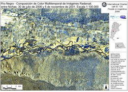
Radarsat Change Detection 30/07/2006
版权: CSA 2006 Image processing, map created 30/07/2006 by INA (National Water Institute of Argentina). Image processing and information extraction by CONAE (Argentina Space Agency). Analysis and map creation by INA in the framework of International Charter Space and Major Disasters.
12.5m resolution
Information about the Product
已获得: 30/07/2006
源: RADARSAT-1
 返回完整的响应档案

 English
 Spanish
 French
 Chinese
 Russian
 Portuguese

