 English
 Spanish
 French
 Chinese
 Russian
 Portuguese
 最新宪章启动
Charter activations
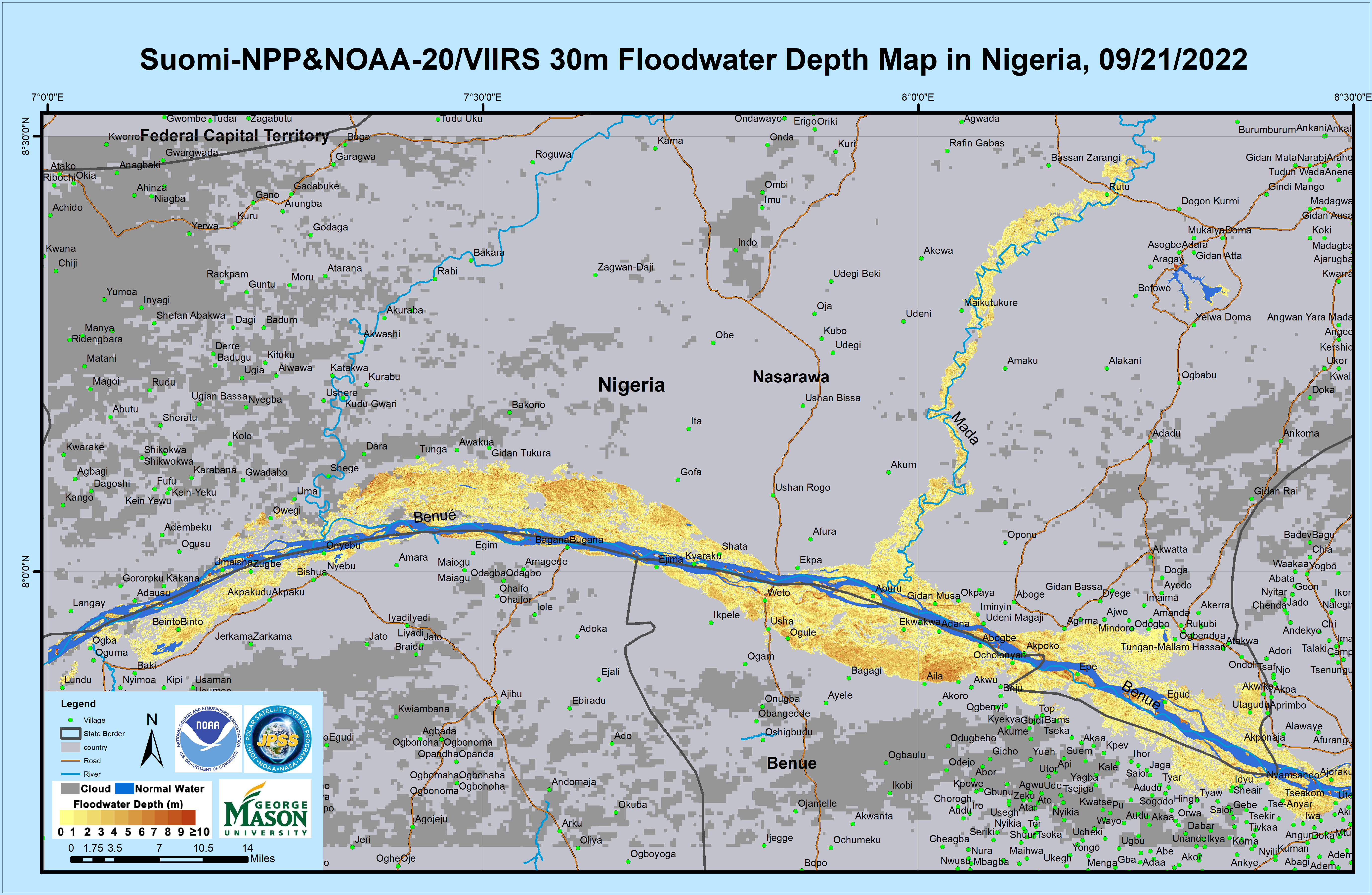
Flood in Nigeria
Torrential rain caused flooding in Nigeria. Every state in the country was affected, but Jigawa state particularly experienced heavy flooding.
92 people were reported killed and hundreds left homeless. The floods submerged buildings and agriculture, and there were concerns that the Niger and Benue Rivers may flood as their water levels got higher.
| 事件类型: | Floods |
| 事件地点: | Nigeria |
| 启动宪章的日期: | 2022-09-15 |
| 宪章启动时间: | 17:48 |
| 宪章启动时区: | UTC+02:00 |
| 宪章要求者: | NEMA |
| 启动ID: | 777 |
| 项目经理: | Oyewumi Ademuyiwa (National Space Research and Development Agency (NASRDA)) |
| act-value-adders: | Mauro Arcorace (Terradue) |
Products

Flood extent in Ndokwa East, Oshimili South and Ogbaru LGA
版权: ESRI (2022)
RADARSAT Constellation Mission Imagery © Government of Canada (2022) - RADARSAT is an official mark of the Canadian Space Agency
Map produced by National Space Research and Development Agency
Information about the Product
已获得: 12/10/2022, 17/08/2022
源: RCM
类别: Delineation Monitoring Maps


Flood extent along the river Benue in Doma, Makurdi and GUMA (Upstream Loko), Nigeria.
版权: Contains modified Copernicus Sentinel data (2022)
OpenStreetMap (2020)
Map produced by the National Space Research and Development Agency
Information about the Product
已获得: 25/09/2022, 26/09/2022
源: Sentinel-1
类别: Delineation Monitoring Maps

Flood extent along the river Benue in Guma and Logo LGA's (Upstream Loko), Nigeria.
版权: Contains modified Copernicus Sentinel data (2022)
OpenStreetMap (2020)
Map produced by the National Space Research and Development Agency
Information about the Product
已获得: 26/09/2022
源: Sentinel-1
类别: Delineation Monitoring Maps

Flooded Extent in Ibi, Shinye, Rafin Soja, Dogan, Gidan Isubu, Gidan Ulu, Jubu and Gidan El Haji Communities along the River Benue Channel, Nigeria.
版权: Contains modified Copernicus Sentinel data (2022)
Esri (2020)
OpenStreetMap (2020)
Map produced by the National Space Research and Development Agency
Information about the Product
已获得: 20/09/2020, 26/09/2022, 10/10/2020
源: Sentinel-1
类别: Delineation Monitoring Maps

Flood extent along the river Benue channel in Agatu, Doma, Gwer West and Makurdi LGAs (Upstream Loko), Nigeria.
版权: Contains modified Copernicus Sentinel data (2022)
Map produced by National Space Research and Development Agency
Information about the Product
已获得: 26/09/2022, 26/10/2022, 25/08/2022
源: Sentinel-1
类别: Delineation Monitoring Maps

Flooded Area: Benue River - Niger River Confluence, Nigeria. Situation on 24/09/2022. Affected Buildings. Koton Karifi, Lokoja Close-Up.
版权: Contains modified Copernicus Sentinel data (2022)
Map produced by National Space Research and Development Agency
Information about the Product
已获得: 24/09/2022
源: Sentinel-2
类别: Delineation Monitoring Maps

Flooded Villages Between Ojigagala and Abujaga in Kogi State, Nigeria
版权: RADARSAT Constellation Mission Imagery © Government of Canada (2022) - RADARSAT is an official mark of the Canadian Space Agency
Map produced by National Space Research and Development Agency
Information about the Product
已获得: 30/09/2022
源: RCM
类别: Reference Map

Flood extent along the river Benue channel in Agatu, Doma, Gwer West and Makurdi LGA's (Upstream Loko), Nigeria
版权: OpenStreetMap(2020)
Contains modified Copernicus Sentinel data (2022)
Map produced by National Space Research and Development Agency
Information about the Product
已获得: 26/09/2022
源: Sentinel-1
类别: Delineation Monitoring Maps

Flood extent along the river Benue channel in Benue and Taraba state (upstream loko), Nigeria
版权: Contains modified Copernicus Sentinel data (2022)
Map produced by the National Space Research and Development Agency.
Information about the Product
已获得: 26/09/2022
源: Sentinel-1
类别: Delineation Monitoring Maps

Inundated areas: Bantaji, Wurbo, Gian Atoro, Kwatan, Boya, Hoyan, Sakpa, and Kanon Kabawa communities along the river Benue channel
版权: Contains modified Copernicus Sentinel data (2022)
Map produced by National Space Research and Development Agency.
Information about the Product
已获得: 26/09/2022
源: Sentinel-1
类别: Delineation Monitoring Maps


Inundated areas: Ohelefu west, Adeka, Olegadoba, Oweto, Oweto East and Utogo Lugw Communities along the river Benue channel
版权: Contains modified Copernicus Sentinel data (2022)
OpenStreetMap (2020)
© Planet Labs Inc. (2022)
Map produced by National Space Research and Development Agency
Information about the Product
已获得: Sentinel-1: 19/09/2022
PlanetScope: 05/08/2022
源: Sentinel-1 and PlanetScope
类别: Delineation Monitoring Maps


Inundated areas: Egba, Alia and Olege alla communities along the river Benue channel, Nigeria
版权: Contains modified Copernicus Sentinel data (2022)
OpenStreetMap (2020)
© Planet Labs Inc. (2022)
Map produced by National Space Research and Development Agency
Information about the Product
已获得: Sentinel-1- 19/09/2022, 20/09/2020
PlanetScope: 05/08/2022
源: Sentinel-1 and PlanetScope
类别: Delineation Monitoring Maps


Flooded Cropland - Benue River; Benue-Niger confluence. Overview Map, Close-Up Maps and Table on Flooded Cropland Area per District.
版权: Contains modified Copernicus Sentinel data (2022)
Map produced by National Space Research and Development Agency
Information about the Product
已获得: 19/09/2022
源: Sentinel-1
类别: Delineation Map


Inundated areas: Aila community along the river Benue
版权: Contains modified Copernicus Sentinel data (2022)
PlanetScope © Planet Labs Inc. (2022)
Map produced by the National Space Research and Development Agency
Information about the Product
已获得: Sentinel-1: 07/09/2022, 26/08/2022
PlanetScope: 08/08/2022
源: Sentinel-1 / PlanetScope
类别: Delineation Monitoring Maps


Inundated areas: Oweto, West Ohelefu, Adeka, Utuogolugw and Olegadoba communities along the river Benue, Nigeria
版权: Contains modified Copernicus Sentinel data (2022)
© Planet Labs Inc. (2022)
Map produced by the National Space Research and Development Agency
Information about the Product
已获得: Sentinel-1: 26/08/2022, 07/09/2022
PlanetScope: 05/08/2022
源: Sentinel-1 / PlanetScope
类别: Delineation Monitoring Maps

 返回完整的响应档案

