 English
 Spanish
 French
 Chinese
 Russian
 Portuguese
 最新宪章启动
Charter activations
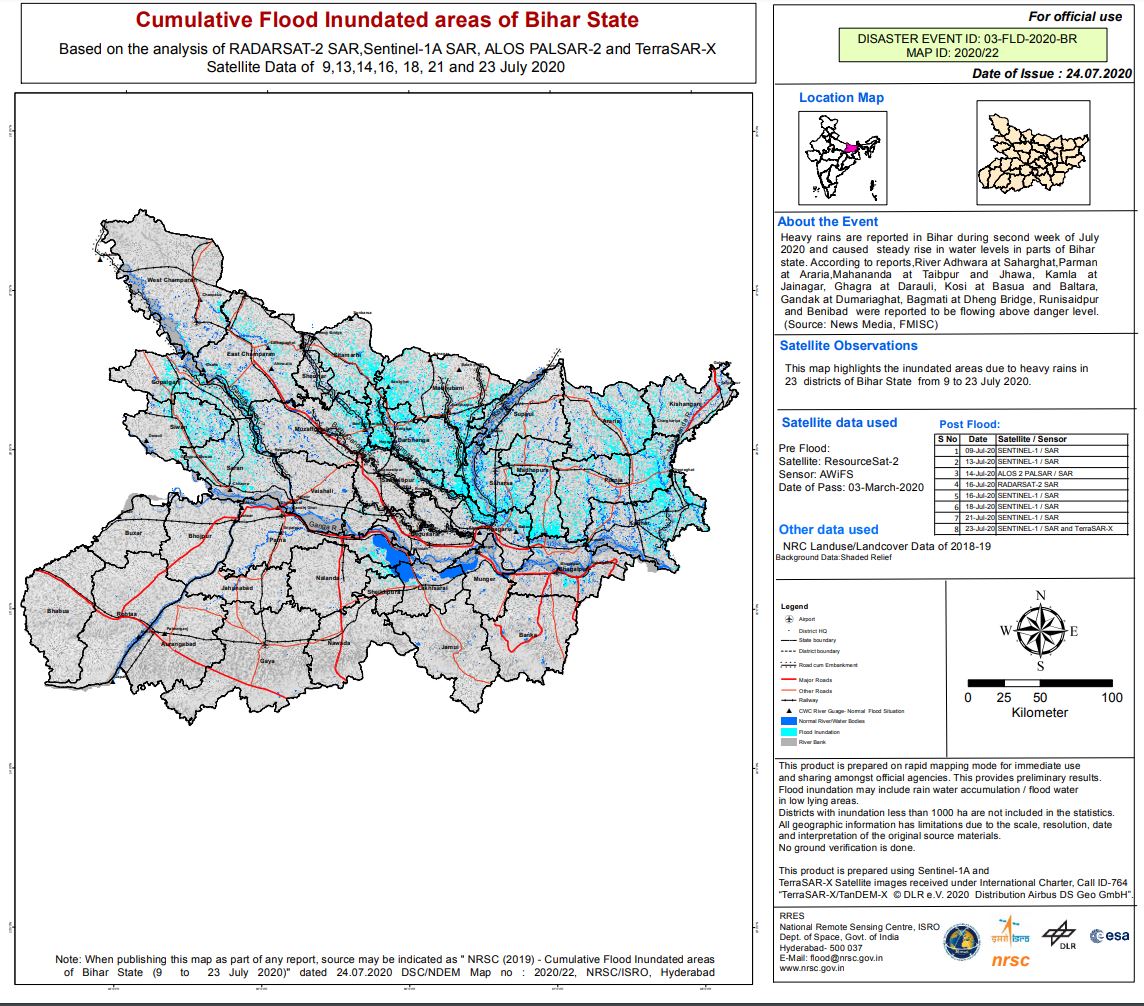
Flood in India
Heavy rainfall has caused widespread flooding in northern areas of Bihar and Meghalaya. Eight districts have experienced the worst of the rainfall which has affected 400,000 people.
The National Disaster Response Force (NDRF) has positioned 122 teams in 20 states out of which 19 have been deployed in Bihar, and 12 in Assam.
Rivers overflowing have destroyed homes and crops with the floods and landslides killing 26 people in Assam with a total death toll of 87.
Indian Meteorological Department has forecast more rains for the coming days keeping the area on high alert with further flash flooding predicted.
| 事件类型: | Floods |
| 事件地点: | India |
| 启动宪章的日期: | 2020-07-22 |
| 宪章启动时间: | 16:49 |
| 宪章启动时区: | UTC+05:30 |
| 宪章要求者: | ISRO |
| 启动ID: | 663 |
| 项目经理: | NRSC |
Products
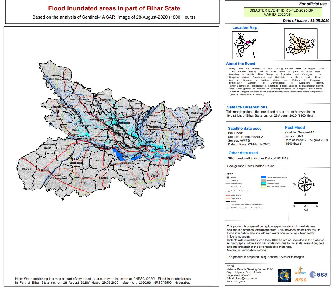
Flood areas in part of Bihar State, India
版权: Contains modified Copernicus Sentinel data (2020)
ResourceSat-2 data and products © ISRO (2020) - All rights reserved
Map produced by NRSC/ISRO
Information about the Product
已获得: ResourceSat-2: 03/03/2020
Sentinel-1: 28/08/2020
源: ResourceSat-2
Sentinel-1
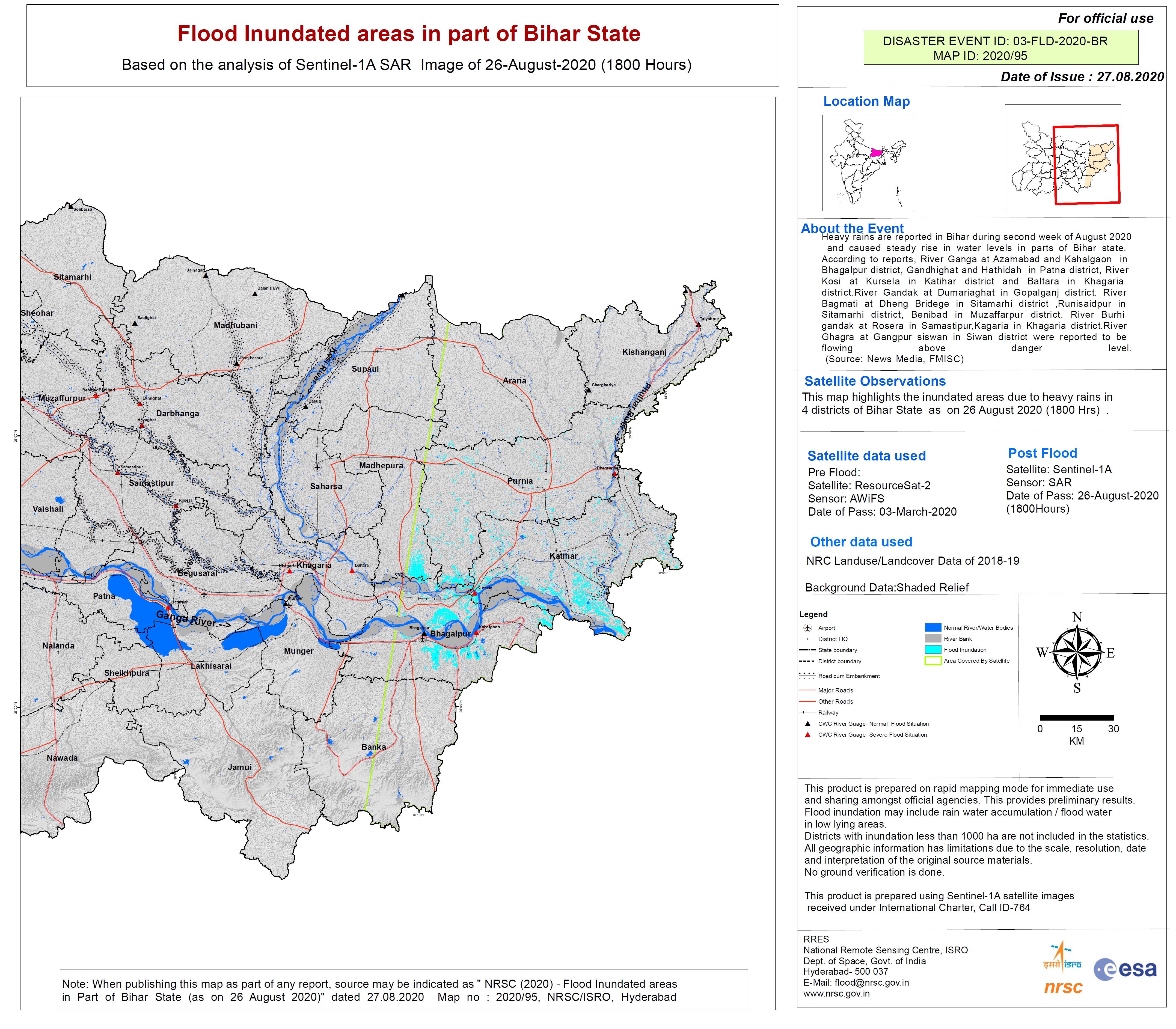
Flooded areas in part of Bihar State as on 20 August 2020
版权: © DLR e.V. (2020), Distribution Airbus DS Geo GmbH
ResourceSat-2 data and products © ISRO (2020) - All rights reserved
Map produced by ISRO/NRSC
Information about the Product
已获得: ResourceSat-2: 03/03/2020
TanDEM-X: 20/08/2020
源: TanDEM-X / ResourceSat-2
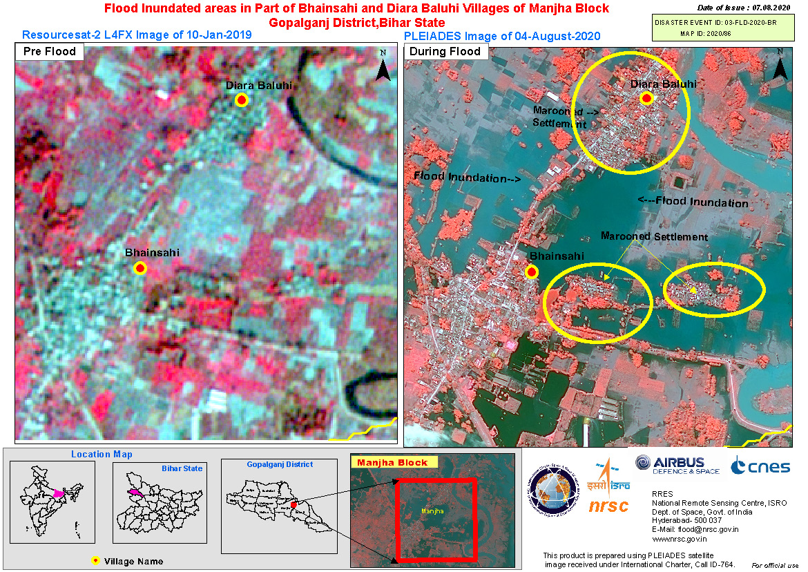
Flood Inundated areas in Part of Bhainsahi and Diara Baluhi Villages of Manjha Block,Gopalganj District, Bihar State, India
版权: ResourceSat-2: Copyright NRSC (2019)
Pleiades: Includes Pleiades material © CNES (2020), Distribution Airbus DS.
Information about the Product
已获得: ResourceSat-2: 10/01/2019
Pleiades: 04/08/2020
源: ResourceSat-2 / Pleiades
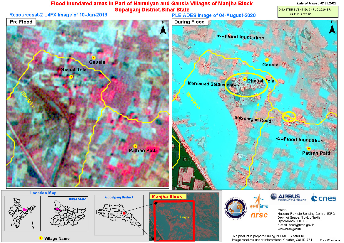
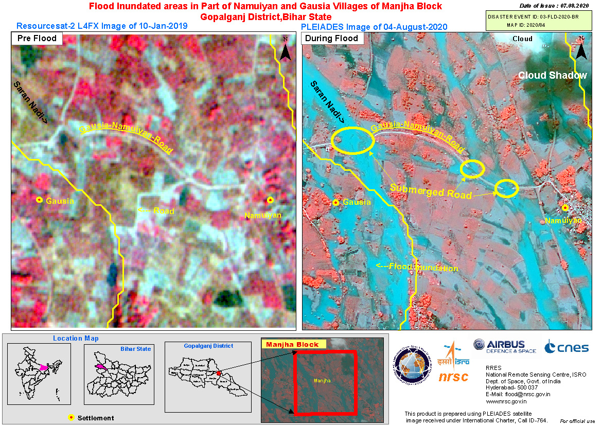
Flood Inundated areas in Part of Namuiyan and Gausia Villages of Manjha Block Gopalganj District, Bihar State, India
版权: ResourceSat-2: Copyright NRSC (2019)
Pleiades: Includes Pleiades material © CNES (2020), Distribution Airbus DS.
Map produced by NRSC
Information about the Product
已获得: ResourceSat-2: 10/01/2019
Pleiades: 04/08/2020
源: ResourceSat-2 / Pleiades
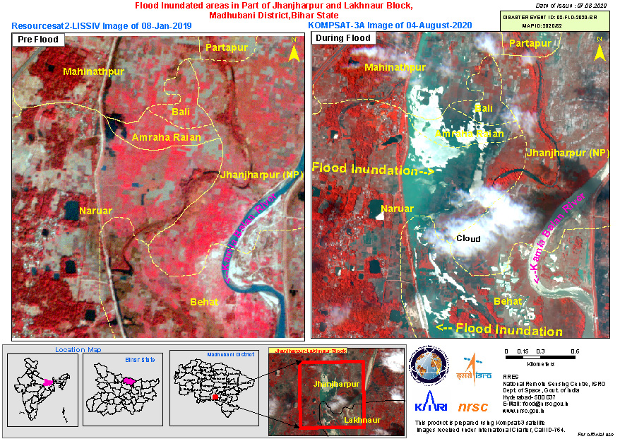
Flood Inundated areas in Part of Jhanjharpur and Lakhnaur Block, Madhubani District, Bihar State, India
版权: ResourceSat-2 Copyright NRSC (2019)
KOMPSAT-3 © KARI (2020).
Map produced by NRSC
Information about the Product
已获得: ResourceSat-2: 08/01/2019
KOMPSAT-3: 04/08/2020
源: ResourceSat-2 / KOMPSAT-3

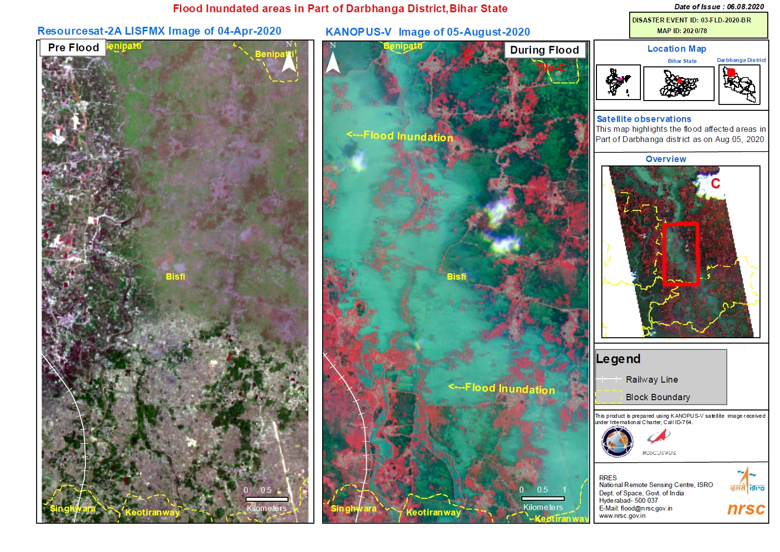
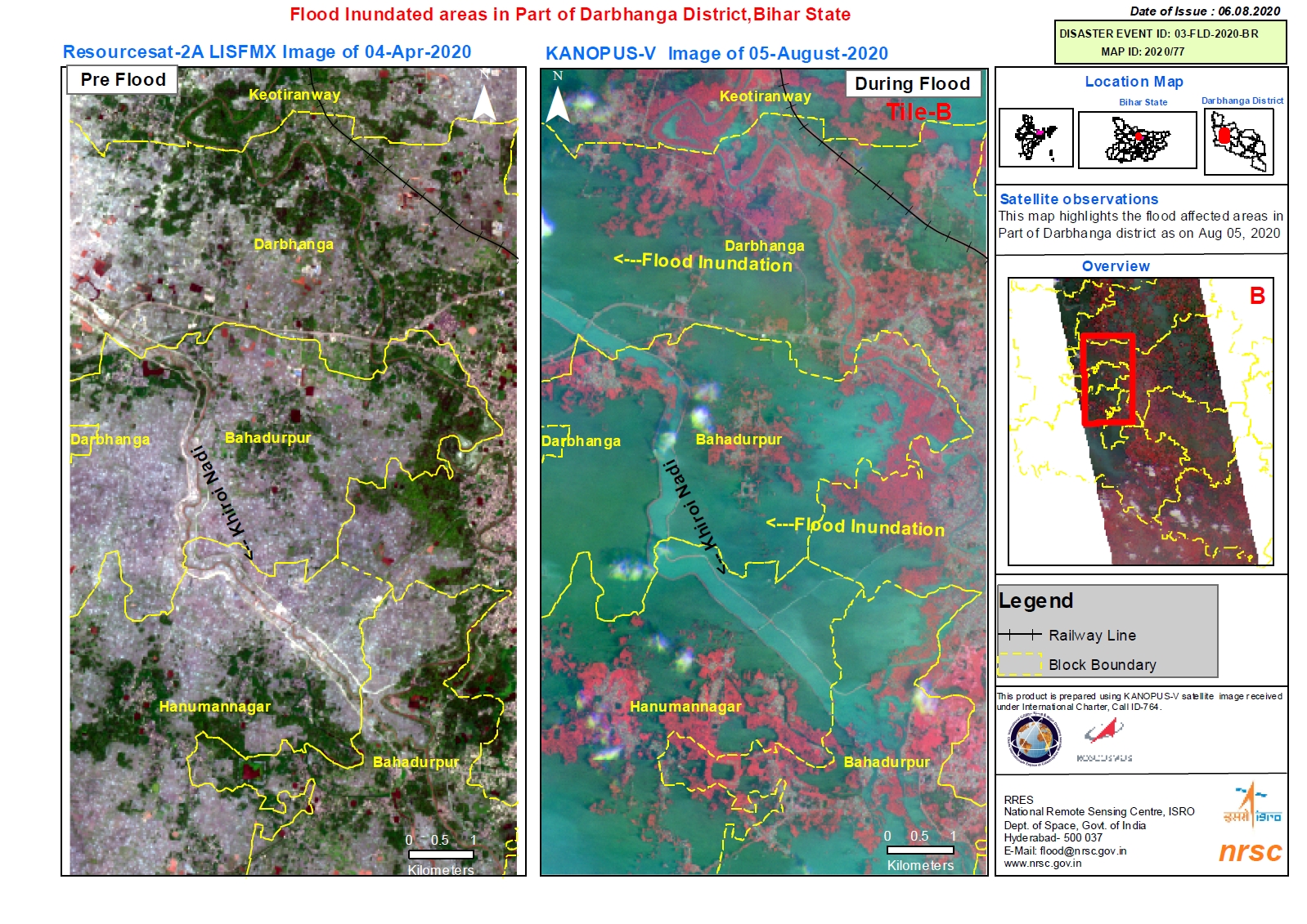
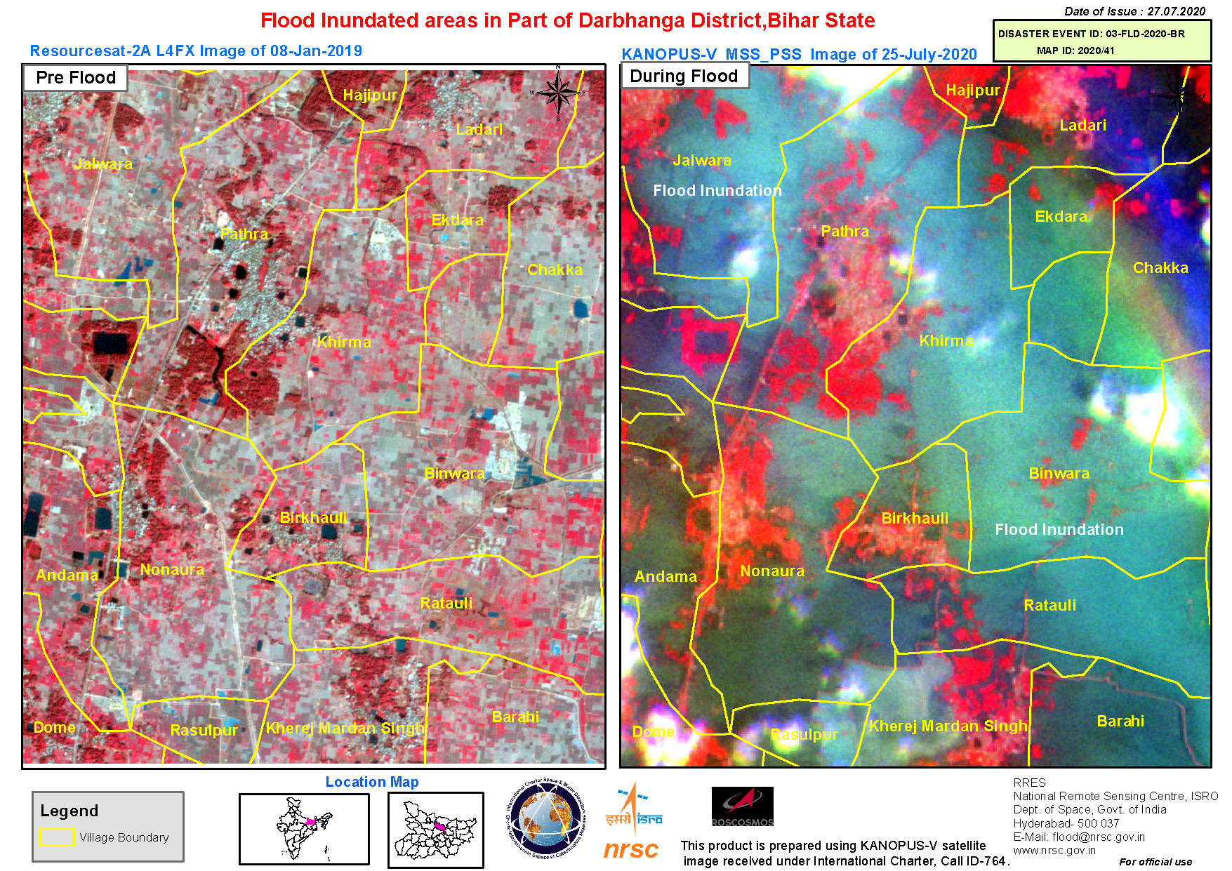
Flood Inundated areas in Part of Darbhanga District, Bihar State, India on 5 Aug 2020 - Tile B
版权: ResourceSat-2 Copyright NRSC (2020)
Kanopus-V © NTs OMZ, All Rights Reserved
Maps produced by NRSC/ISRO
Information about the Product
已获得: ResourceSat-2: 04/04/2020
Kanopus-V: 05/08/2020
源: ResourceSat-2 / Kanopus-V
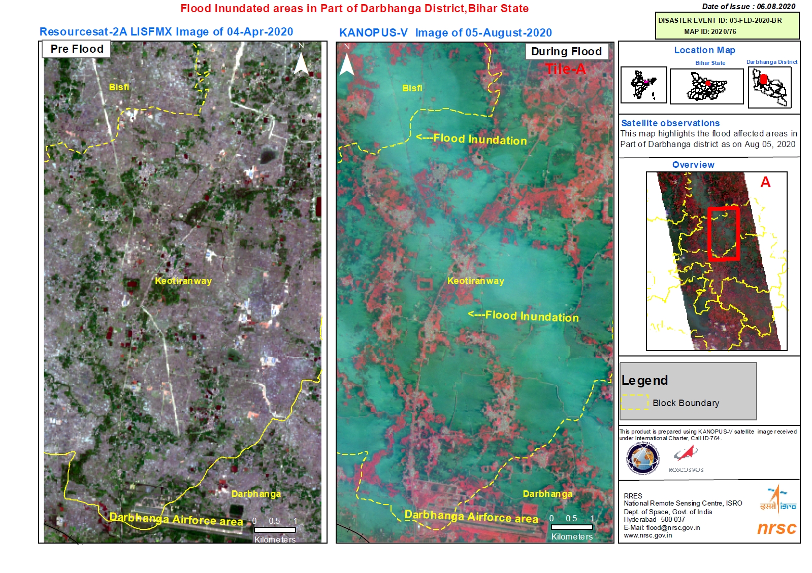
Flood Inundated areas in Part of Darbhanga District, Bihar State, India on 5 August 2020 - Tile A
版权: WorldView-3 © (2020) DigitalGlobe, Inc., Longmont CO USA 80503. DigitalGlobe and the DigitalGlobe logos are trademarks of DigitalGlobe, Inc. The use and/or dissemination of this data and/or of any product in any way derived there from are restricted. Unauthorized use and/or dissemination is prohibited
Kanopus-V © NTs OMZ, All Rights Reserved
Maps produced by NRSC/ISRO
Information about the Product
已获得: WorldView-3: 05/04/2020
Kanopus-V: 05/08/2020
源: Kanopus-V / WorldView-3
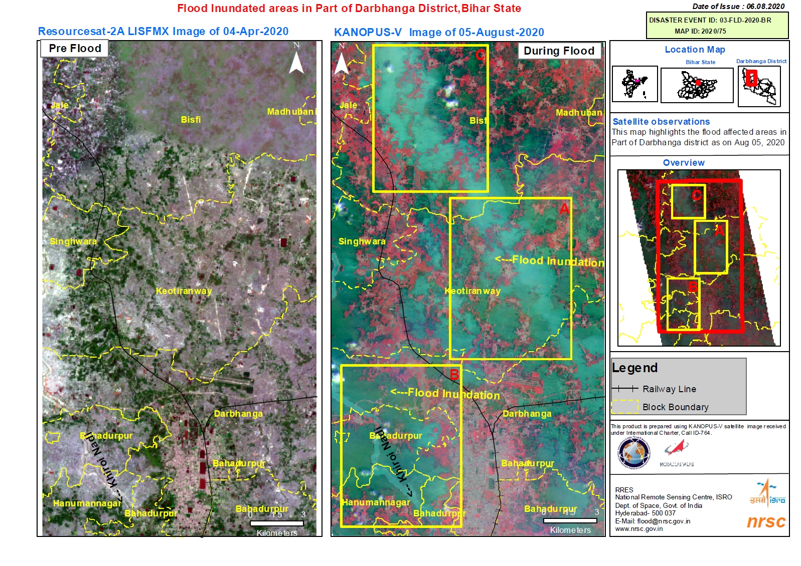
Flood Inundated areas in Part of Darbhanga District, Bihar State, India
版权: WorldView-3 © (2020) DigitalGlobe, Inc., Longmont CO USA 80503. DigitalGlobe and the DigitalGlobe logos are trademarks of DigitalGlobe, Inc. The use and/or dissemination of this data and/or of any product in any way derived there from are restricted. Unauthorized use and/or dissemination is prohibited
Kanopus-V © NTs OMZ, All Rights Reserved
Maps produced by NRSC/ISRO
Information about the Product
已获得: WorldView-3: 05/04/2020
Kanopus-V: 05/08/2020
源: Kanopus-V / WorldView-3
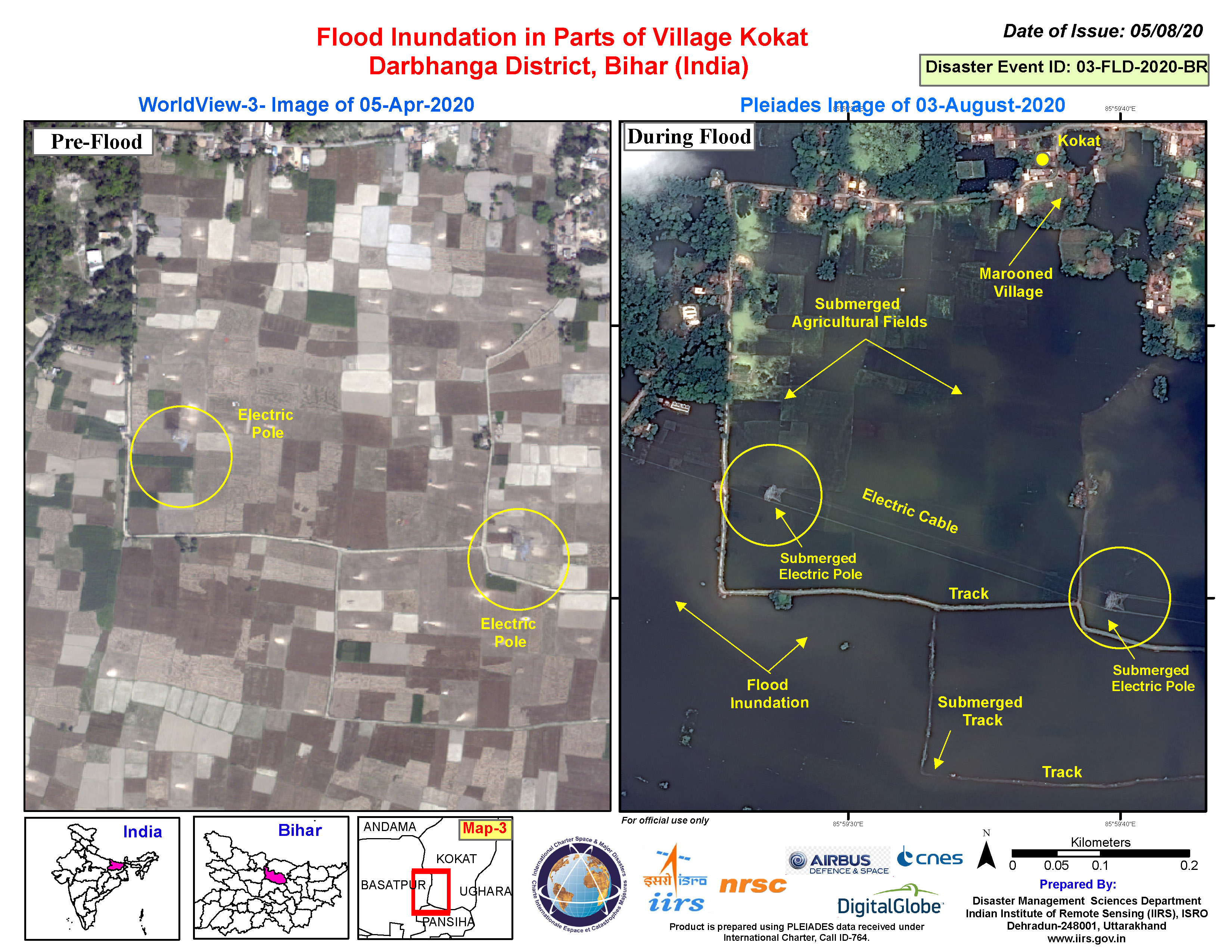
Flood inundation in Kokat Village, Darbhanga District, Bihar, India
版权: WorldView-3 © (2020) DigitalGlobe, Inc., Longmont CO USA 80503. DigitalGlobe and the DigitalGlobe logos are trademarks of DigitalGlobe, Inc. The use and/or dissemination of this data and/or of any product in any way derived there from are restricted. Unauthorized use and/or dissemination is prohibited
Includes Pleiades material © CNES (2020), Distribution Airbus DS.
Map produced by NRSC/ISRO
Information about the Product
已获得: WorldView-3: 05/04/2020
Pleiades: 03/08/2020
源: WorldView-3 / Pleiades
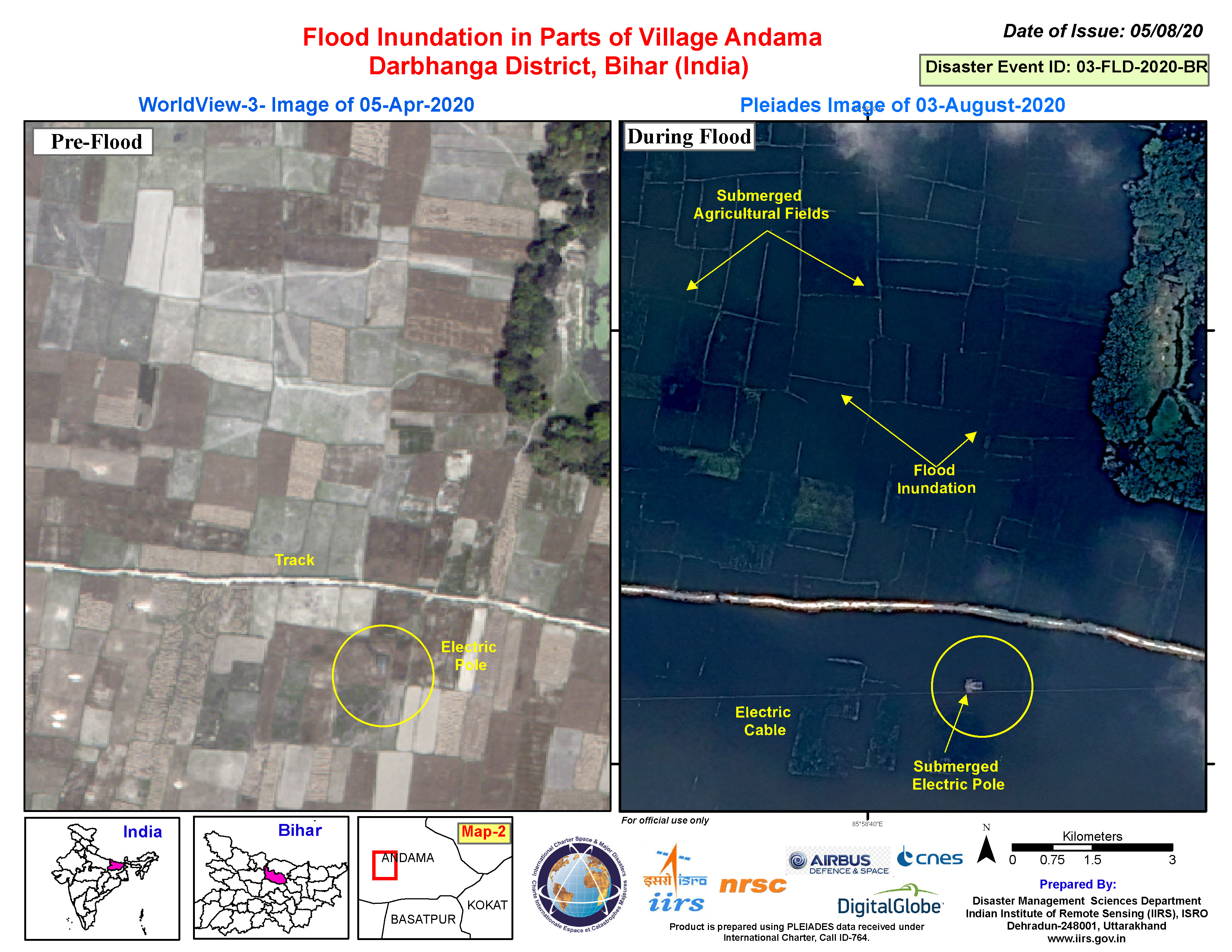
Flood inundation in Andama Village, Darbhanga District, Bihar, India
版权: WorldView-3 © (2020) DigitalGlobe, Inc., Longmont CO USA 80503. DigitalGlobe and the DigitalGlobe logos are trademarks of DigitalGlobe, Inc. The use and/or dissemination of this data and/or of any product in any way derived there from are restricted. Unauthorized use and/or dissemination is prohibited
Includes Pleiades material © CNES (2020), Distribution Airbus DS.
Map produced by NRSC/ISRO
Information about the Product
已获得: WorldView-3: 05/04/2020
Pleiades: 03/08/2020
源: WorldView-3 / Pleiades
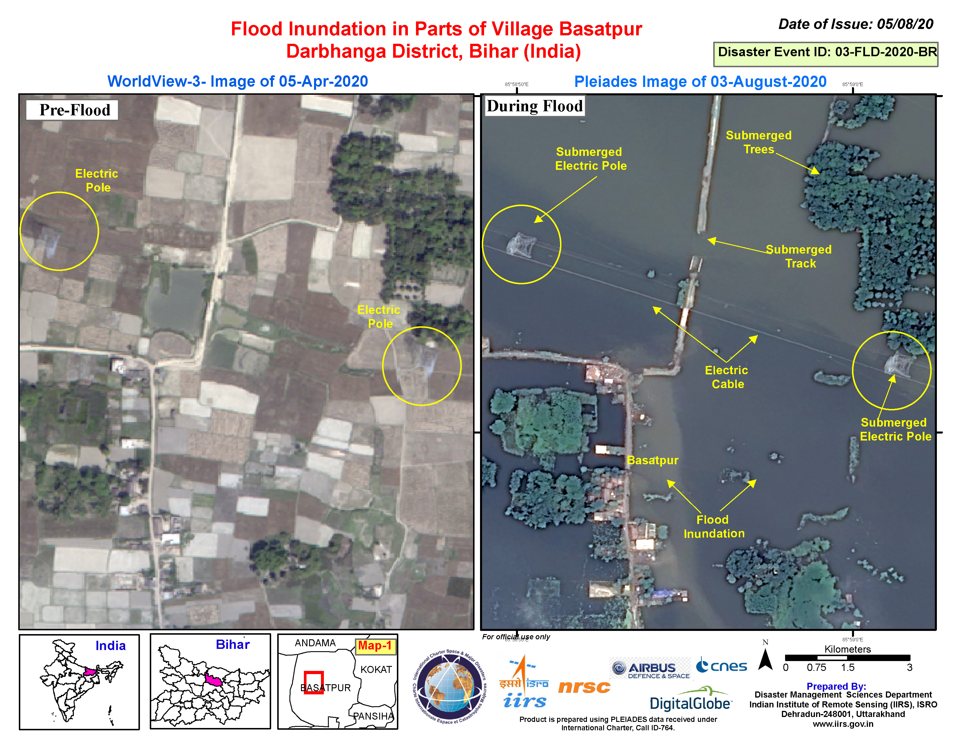
Flood inundation in parts of Basatpur Village, Darbhanga District, Bihar, India
版权: WorldView-3 © (2020) DigitalGlobe, Inc., Longmont CO USA 80503. DigitalGlobe and the DigitalGlobe logos are trademarks of DigitalGlobe, Inc. The use and/or dissemination of this data and/or of any product in any way derived there from are restricted. Unauthorized use and/or dissemination is prohibited
Includes Pleiades material © CNES (2020), Distribution Airbus DS.
Map produced by NRSC/ISRO
Information about the Product
已获得: WorldView-3: 05/04/2020
Pleiades: 03/08/2020
源: WorldView-3 / Pleiades
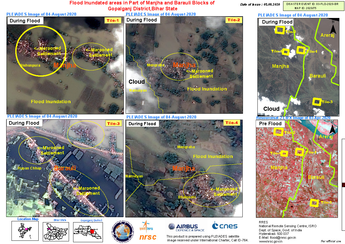
Flood inundated areas in part of Manjha and Barauli Blocks of Gopalganj District, Bihar State, India
版权: ResourceSat-2 Copyright NRSC (2020)
Includes Pleiades material © CNES (2020), Distribution Airbus DS.
Map produced by NRSC/ISRO
Information about the Product
已获得: ResourceSat-2: 03/04/2020
Pleiades: 04/08/2020
源: ResourceSat-2 / Pleiades

Flood inundated areas in part of Chak Pahar Village of Bahadurpur Block, Darbhanga District, Bihar State, India
版权: WorldView-3 © (2020) DigitalGlobe, Inc., Longmont CO USA 80503. DigitalGlobe and the DigitalGlobe logos are trademarks of DigitalGlobe, Inc. The use and/or dissemination of this data and/or of any product in any way derived there from are restricted. Unauthorized use and/or dissemination is prohibited
Includes Pleiades material © CNES (2020), Distribution Airbus DS.
Map produced by NRSC/ISRO
Information about the Product
已获得: WorldView-3: 05/04/2020
Pleiades: 03/08/2020
源: WorldView-3 / Pleiades
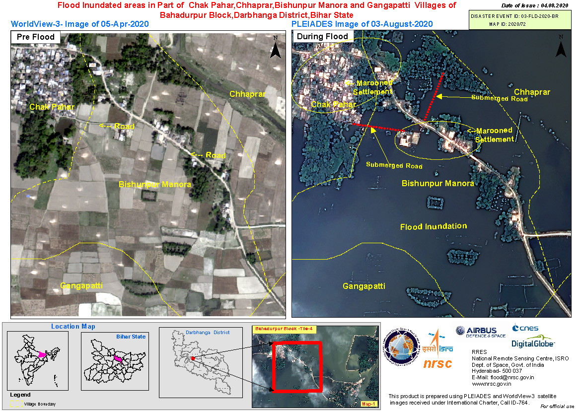
Flood inundated areas in part of Chak Pahar, Chhaprar, Bishunpur Manora and Gangapatti Villages of Bahadurpur Block, Darbhanga District, Bihar State, India
版权: WorldView-3 © (2020) DigitalGlobe, Inc., Longmont CO USA 80503. DigitalGlobe and the DigitalGlobe logos are trademarks of DigitalGlobe, Inc. The use and/or dissemination of this data and/or of any product in any way derived there from are restricted. Unauthorized use and/or dissemination is prohibited
Includes Pleiades material © CNES (2020), Distribution Airbus DS.
Map produced by NRSC/ISRO
Information about the Product
已获得: WorldView-3: 05/04/2020
Pleiades: 03/08/2020
源: WorldView-3 / Pleiades
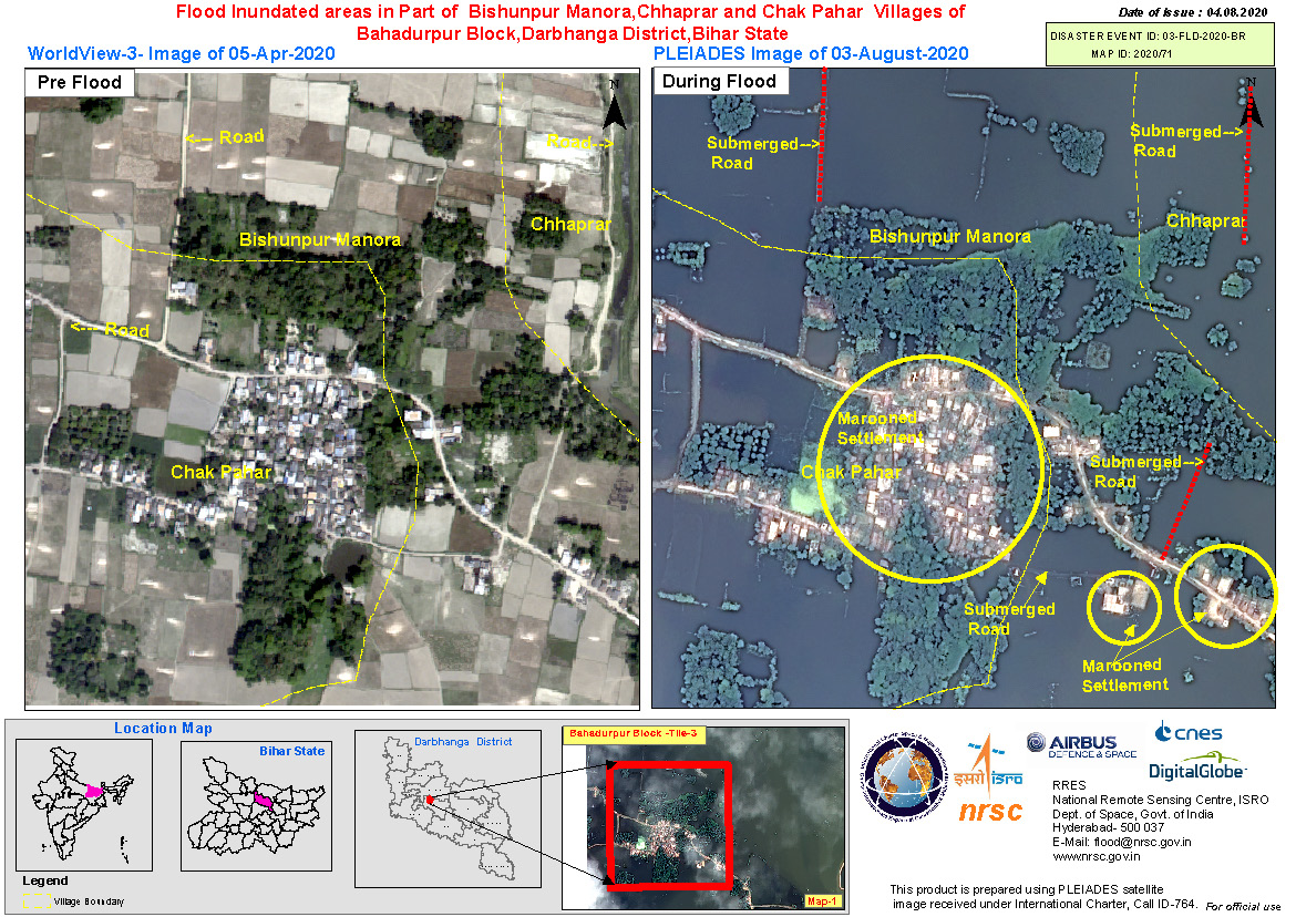
Flood inundated areas in part of Bishunpur Manora, Chhaprar and Chak Pahar Villages of Bahadurpur Block, Darbhanga District, Bihar State, India
版权: Includes Pleiades material © CNES (2020), Distribution Airbus DS.
WorldView-3 © (2020) DigitalGlobe, Inc., Longmont CO USA 80503. DigitalGlobe and the DigitalGlobe logos are trademarks of DigitalGlobe, Inc. The use and/or dissemination of this data and/or of any product in any way derived there from are restricted. Unauthorized use and/or dissemination is prohibited
Map produced by NRSC/ISRO
Information about the Product
已获得: Pleiades: 03/08/2020
WorldView-3: 05/04/2020
源: Pleiades / WorldView-3

Flood Inundated areas in part of Chhaprar and Gharghata Villages of Bahadurpur Block, Darbhanga District, Bihar State, India
版权: Includes Pleiades material © CNES (2020), Distribution Airbus DS.
WorldView-3 © (2020) DigitalGlobe, Inc., Longmont CO USA 80503. DigitalGlobe and the DigitalGlobe logos are trademarks of DigitalGlobe, Inc. The use and/or dissemination of this data and/or of any product in any way derived there from are restricted. Unauthorized use and/or dissemination is prohibited
Map produced by NRSC/ISRO
Information about the Product
已获得: Pleiades: 03/08/2020
WorldView-3: 05/04/2020
源: Pleiades / WorldView-3

Flood inundated areas in part of Chhaprar, Kamala Patti, Bali Asli, Pokhar Bhinda and Pirari Villages of Bahadurpur Block, Darbhanga District, Bihar State, India
版权: Includes Pleiades material © CNES (2020), Distribution Airbus DS.
WorldView-3 © (2020) DigitalGlobe, Inc., Longmont CO USA 80503. DigitalGlobe and the DigitalGlobe logos are trademarks of DigitalGlobe, Inc. The use and/or dissemination of this data and/or of any product in any way derived there from are restricted. Unauthorized use and/or dissemination is prohibited
Map produced by NRSC/ISRO
Information about the Product
已获得: Pleiades: 03/08/2020
WorldView-3: 05/04/2020
源: Pleiades / WorldView-3
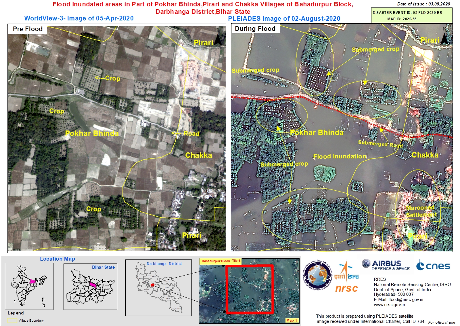
Flood Inundated areas in Part of Pokhar Bhinda, Pirari and Chakka Villages of Bahadurpur Block, Darbhanga District, Bihar State, India
版权: Includes Pleiades material © CNES (2020), Distribution Airbus DS.
WorldView-3 © (2020) DigitalGlobe, Inc., Longmont CO USA 80503. DigitalGlobe and the DigitalGlobe logos are trademarks of DigitalGlobe, Inc. The use and/or dissemination of this data and/or of any product in any way derived there from are restricted. Unauthorized use and/or dissemination is prohibited
Map produced by NRSC
Information about the Product
已获得: Pleiades: 02/08/2020
WorldView-3: 05/04/2020
源: Pleaides / WorldView-3
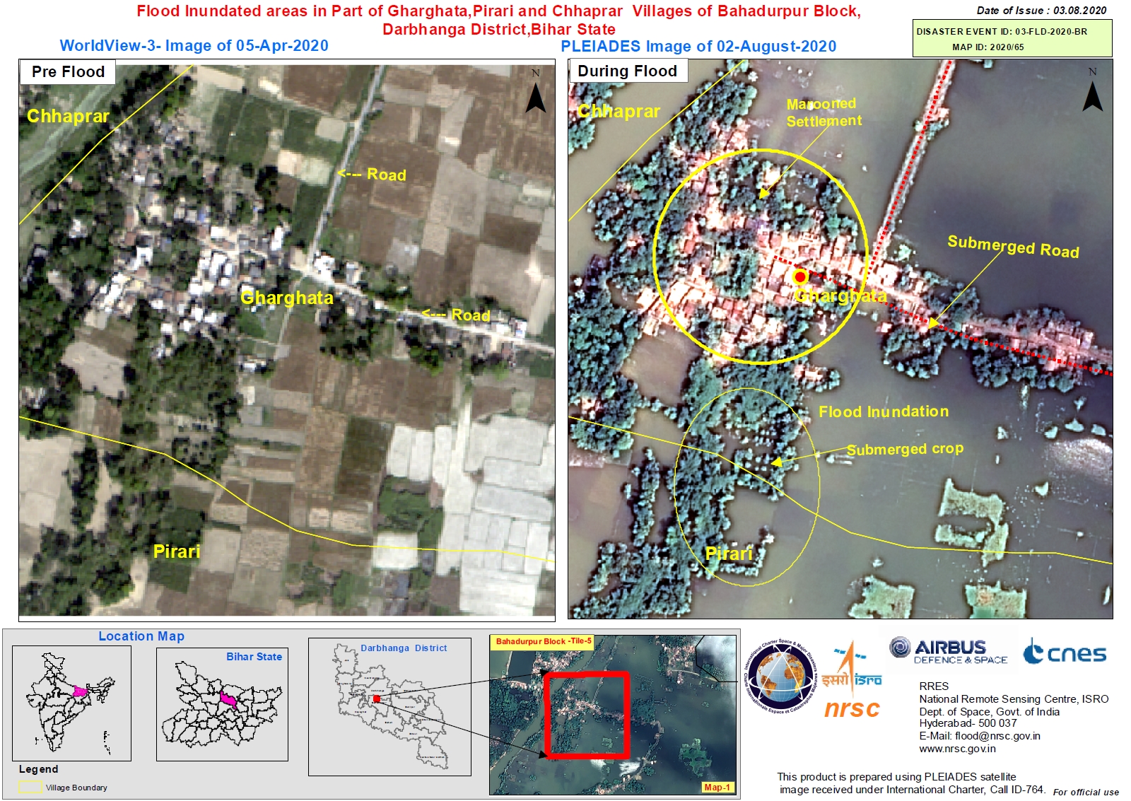
Flood Inundated areas in Part of Gharghata,Pirari and Chhaprar Villages of Bahadurpur Block, Darbhanga District, Bihar State, India
版权: Includes Pleiades material © CNES (2020), Distribution Airbus DS.
WorldView-3 © (2020) DigitalGlobe, Inc., Longmont CO USA 80503. DigitalGlobe and the DigitalGlobe logos are trademarks of DigitalGlobe, Inc. The use and/or dissemination of this data and/or of any product in any way derived there from are restricted. Unauthorized use and/or dissemination is prohibited
Map produced by NRSC
Information about the Product
已获得: Pleiades: 02/08/2020
WorldView-3: 05/04/2020
源: Pleiades / WorldView-3
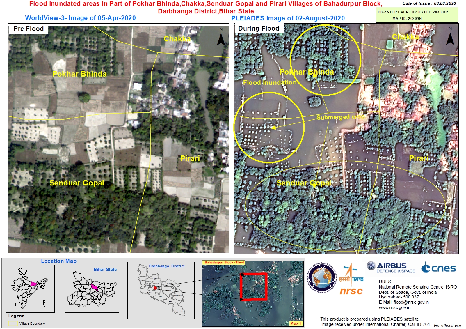
Flood Inundated areas in Part of Pokhar Bhinda, Chakka, Senduar Gopal and Pirari Villages of Bahadurpur Block, Darbhanga District, Bihar State
版权: Includes Pleiades material © CNES (2020), Distribution Airbus DS.
WorldView-3 © (2020) DigitalGlobe, Inc., Longmont CO USA 80503. DigitalGlobe and the DigitalGlobe logos are trademarks of DigitalGlobe, Inc. The use and/or dissemination of this data and/or of any product in any way derived there from are restricted. Unauthorized use and/or dissemination is prohibited
Map produced by NRSC
Information about the Product
已获得: Pleiades: 02/08/2020
WorldView-3: 05/04/2020
源: Pleiades / WorldView-3
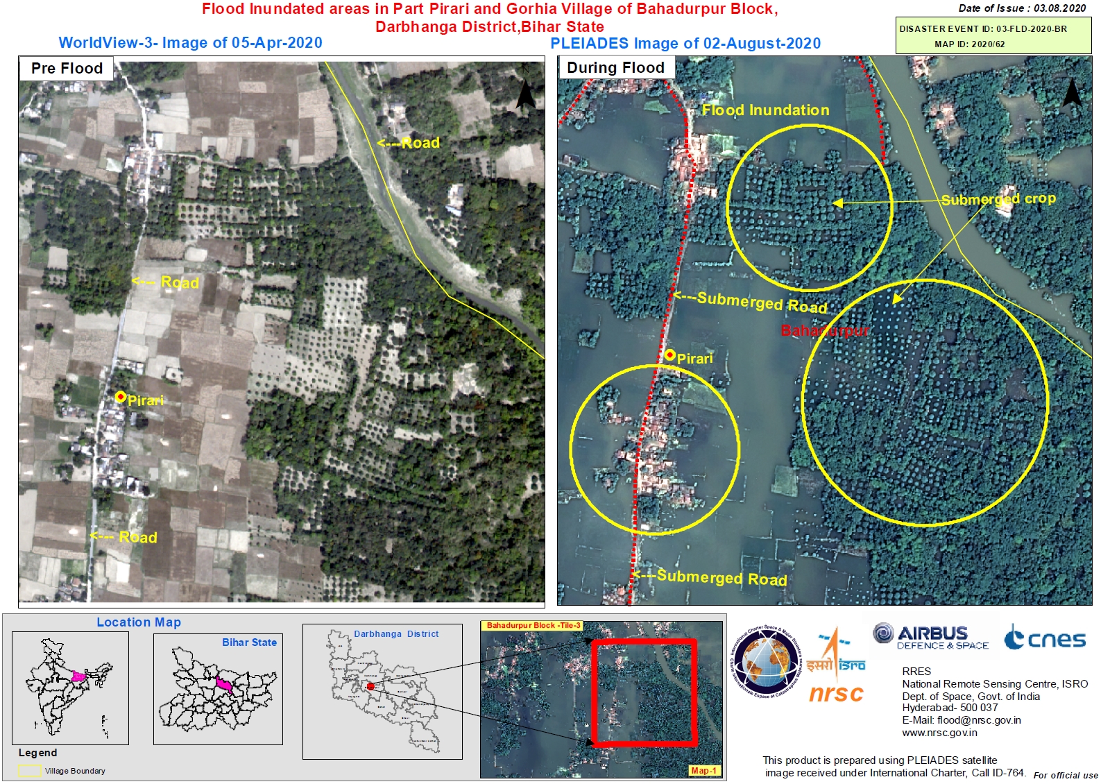
Flood Inundated areas in Part Pirari and Gorhia Villages of Bahadurpur Block, Darbhanga District, Bihar State, India
版权: WorldView-3 © (year of acquistion) DigitalGlobe, Inc., Longmont CO USA 80503. DigitalGlobe and the DigitalGlobe logos are trademarks of DigitalGlobe, Inc. The use and/or dissemination of this data and/or of any product in any way derived there from are restricted. Unauthorized use and/or dissemination is prohibited
Includes Pleiades material © CNES (2020), Distribution Airbus DS.
Map produced by NRSC
Information about the Product
已获得: WorldView-3: 05/04/2020
Pleaides: 02/08/2020
源: WorldView-3 / Pleaides
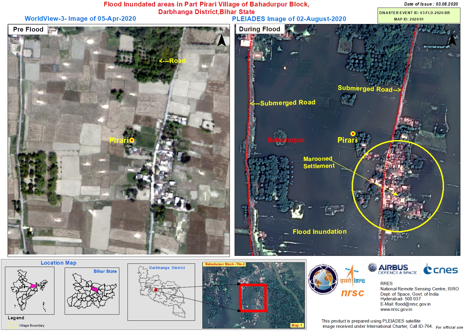
Flood Inundated areas in Part Pirari Village of Bahadurpur Block, Darbhanga District, Bihar State, India
版权: WorldView-3 © (2020) DigitalGlobe, Inc., Longmont CO USA 80503. DigitalGlobe and the DigitalGlobe logos are trademarks of DigitalGlobe, Inc. The use and/or dissemination of this data and/or of any product in any way derived there from are restricted. Unauthorized use and/or dissemination is prohibited
Includes Pleiades material © CNES (2020), Distribution Airbus DS.
Maps produced by NRSC
Information about the Product
已获得: WorldView-3: 05/04/2020
Pleiades: 02/08/2020
源: WorldView-3 / Pleiades
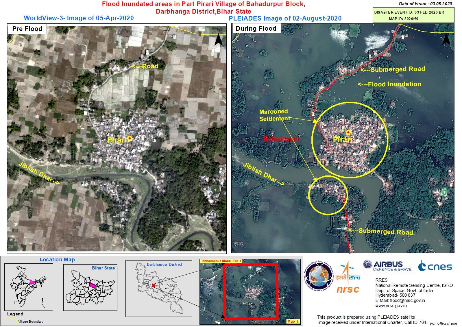
Flood Inundated areas in Part Pirari Village of Bahadurpur Block, Darbhanga District, Bihar State, India
版权: WorldView-3 © (2020) DigitalGlobe, Inc., Longmont CO USA 80503. DigitalGlobe and the DigitalGlobe logos are trademarks of DigitalGlobe, Inc. The use and/or dissemination of this data and/or of any product in any way derived there from are restricted. Unauthorized use and/or dissemination is prohibited
Includes Pleiades material © CNES (2020), Distribution Airbus DS.
Map produced by NRSC
Information about the Product
已获得: WorldView-3: 05/04/2020
Pleiades: 02/08/2020
源: WorldView-3 / Pleiades
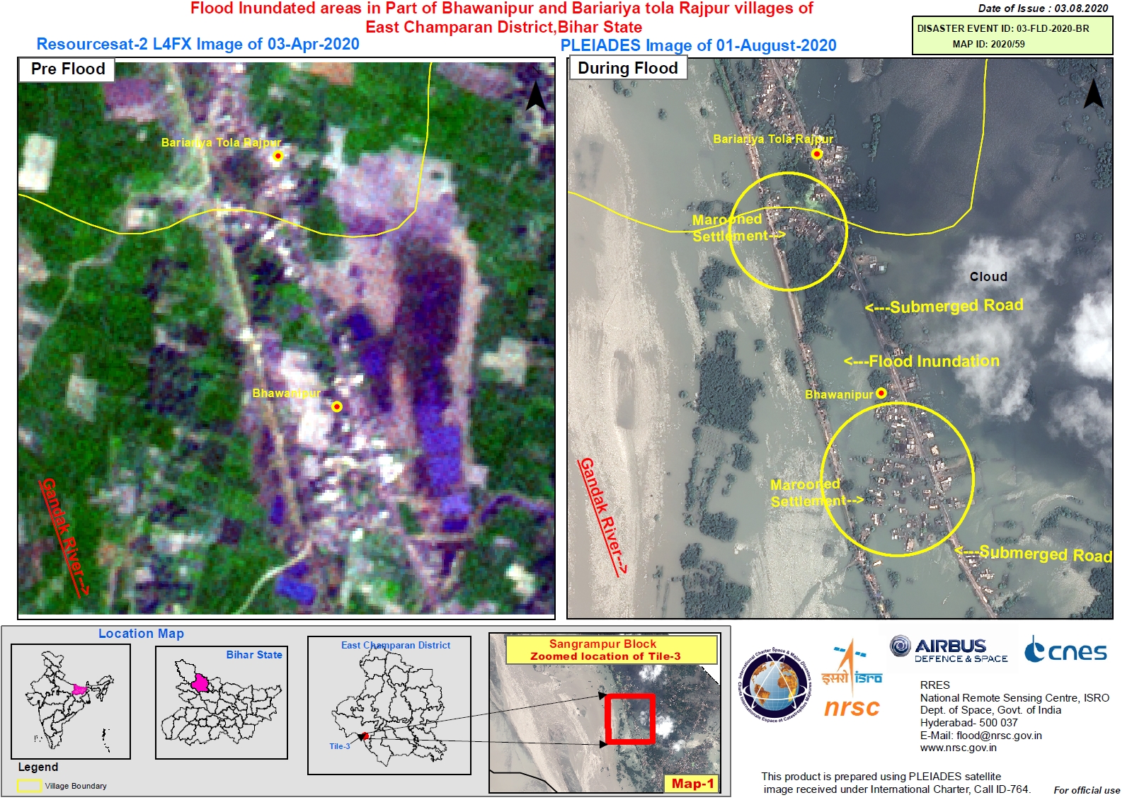
Flood Inundated areas in Part of Bhawanipur and Bariariya tola Rajpur villages of East Champaran District, Bihar State, India
版权: ResourceSat-2: Copyright NRSC (2020)
Includes Pleiades material © CNES (2020), Distribution Airbus DS
Information about the Product
已获得: ResourceSat-2: 03/04/2020
Pleiades: 01/08/2020
源: ResourceSat-2 / Pleiades
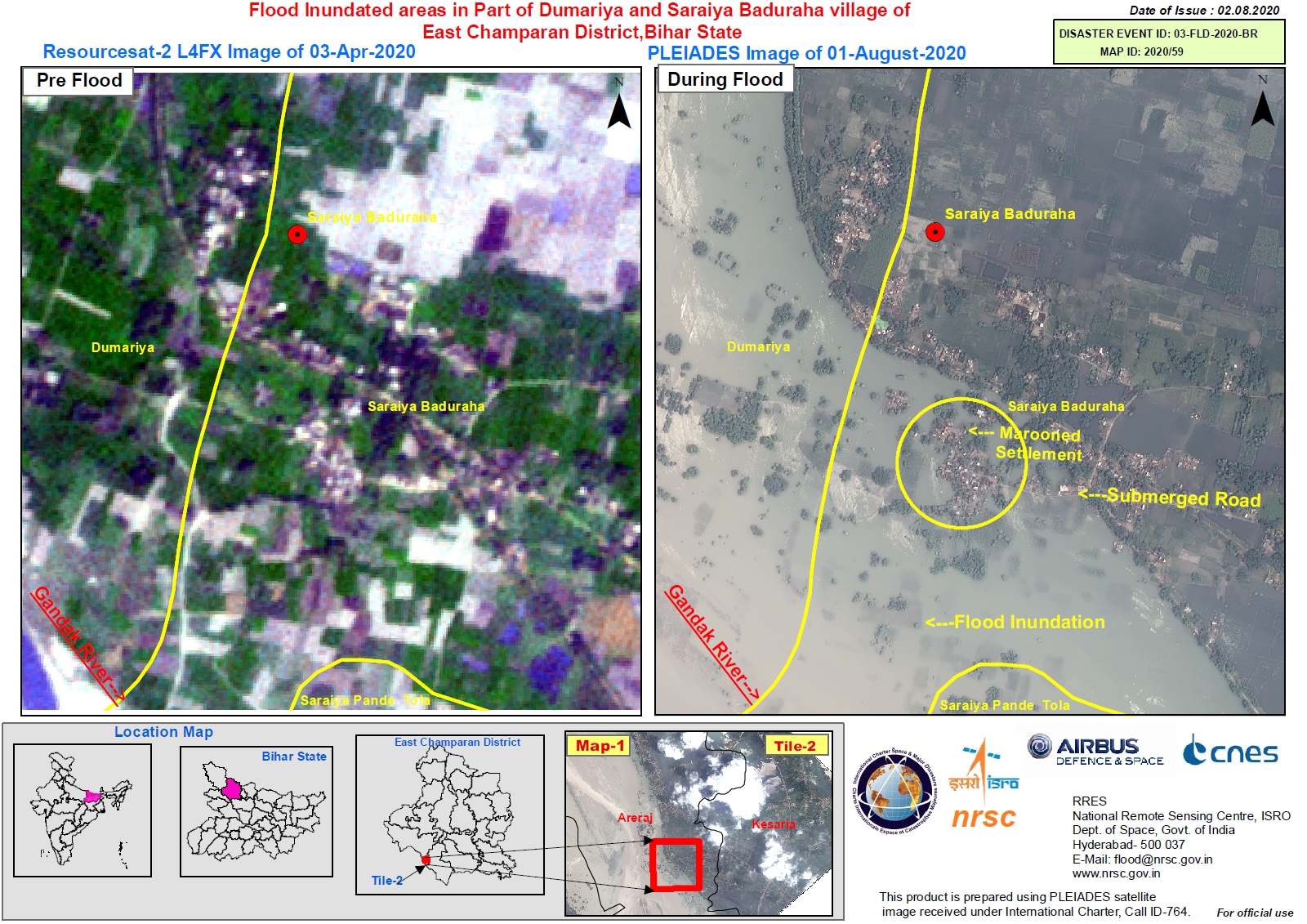
Flood Inundated areas in Part of Dumariya and Saraiya Baduraha villages of East Champaran District, Bihar State, India
版权: Pleiades: Includes Pleiades material © CNES (2020), Distribution Airbus DS.
ResourceSat-2: Copyright NRSC (2020)
Map produced by NRSC
Information about the Product
已获得: Pleiades: 01/08/2020
ResourceSat-2: 03/04/2020
源: Pleiades / ResourceSat-2
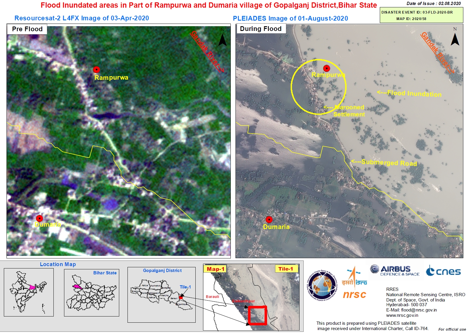
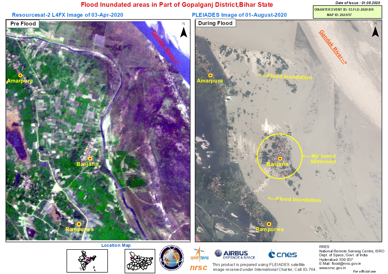
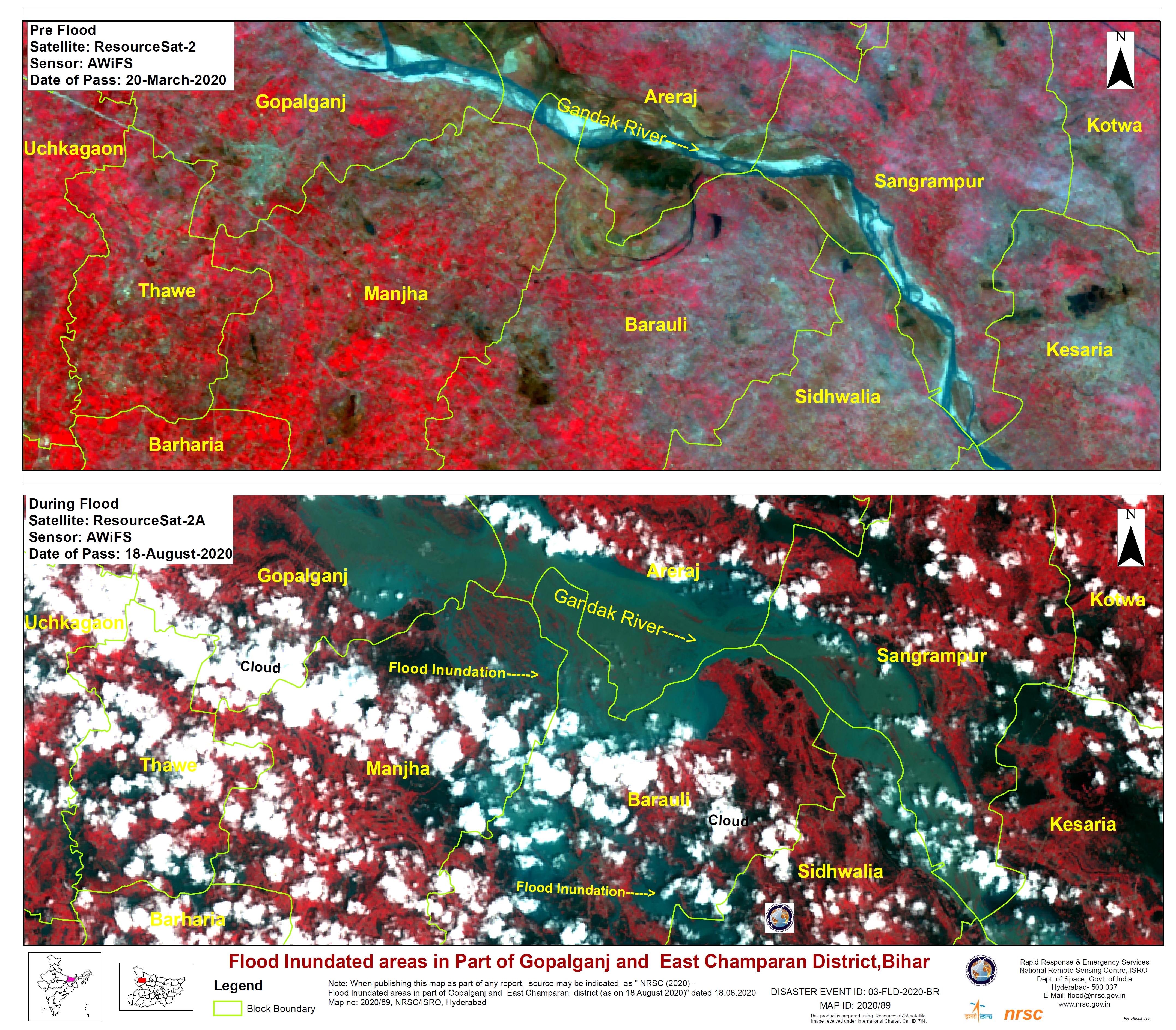
Flood Inundated areas in Part of Gopalganj District, Bihar State, India
版权: Pleaides: Includes Pleiades material © CNES (2020), Distribution Airbus DS.
ResourceSat-2: Copyright NRSC (2020)
Map produced by NRSC/ISRO
Information about the Product
已获得: Pleaides: 01/08/2020
ResourceSat-2: 03/04/2020
源: Pleaides / ResourceSat-2


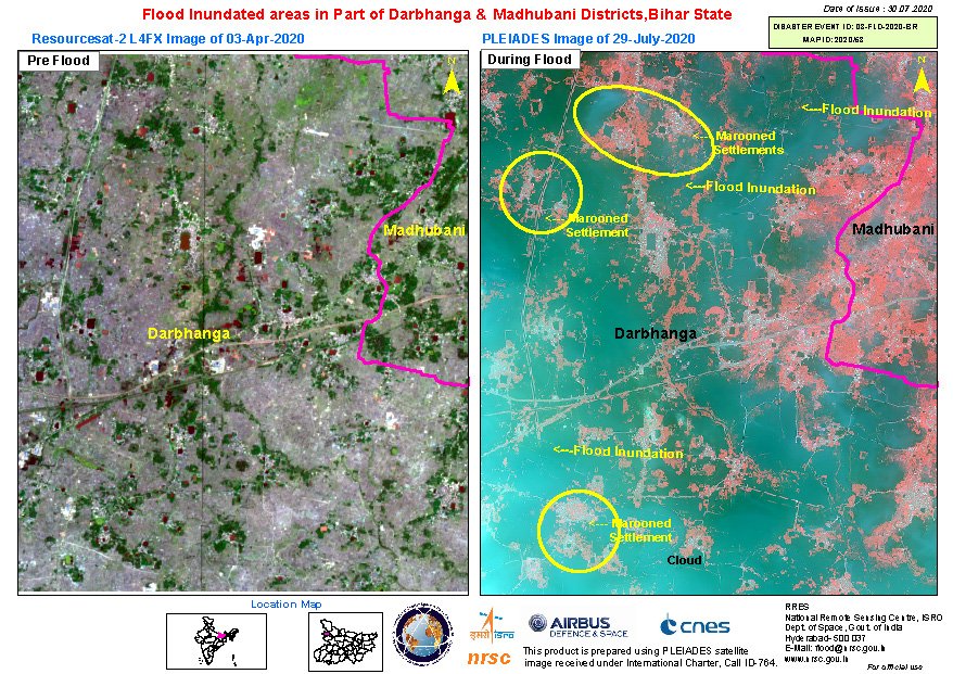
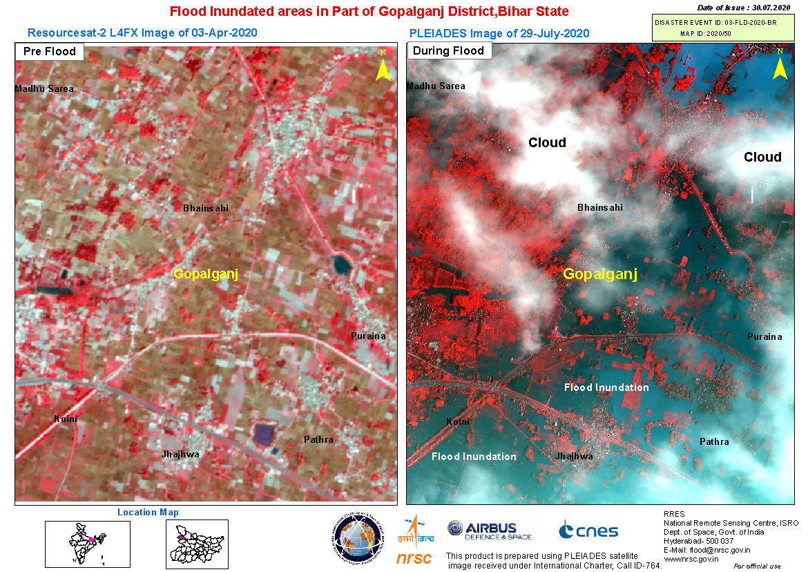
Flood inundated areas in part of Darbhanga and Madhubani Districts, Bihar State, India
版权: ResourceSat-2 Copyright NRSC (2020)
Includes Pleiades material © CNES (2020), Distribution Airbus DS.
Map produced by NRSC/ISRO
Information about the Product
已获得: ResourceSat-2: 03/04/2020
Pleiades: 29/07/2020
源: ResourceSat-2 / Pleiades

Flood inundated areas in part of Darbhanga District, Bihar State, India
版权: Includes Pleiades material © CNES (2020), Distribution Airbus DS.
ResourceSat-2 Copyright NRSC (2020)
Map produced by NRSC/ISRO
Information about the Product
已获得: Pleiades: 29/07/2020
ResourceSat-2: 03/04/2020
源: Pleiades / ResourceSat-2

Flood inundated areas in part of Darbhanga District, Bihar State, India
版权: Includes Pleiades material © CNES (2020), Distribution Airbus DS.
ResourceSat-2 Copyright NRSC (2019)
Map produced by NRSC/ISRO
Information about the Product
已获得: Pleiades: 29/07/2020
ResourceSat-2: 08/01/2019
源: Pleiades / ResourceSat-2


Flood Inundation in part of Deokali village of Darbhanga district, Bihar State, India
版权: Pleiades © CNES (2020) - Distribution: Airbus Defence and Space, all rights reserved
ResourceSat-2 data and products © ISRO (2020) - All rights reserved
Map produced by NRSC/ISRO
Information about the Product
已获得: ResourceSat-2: 08/01/2020
Pleiades: 26/07/2020
源: ResourceSat-2 / Pleaides
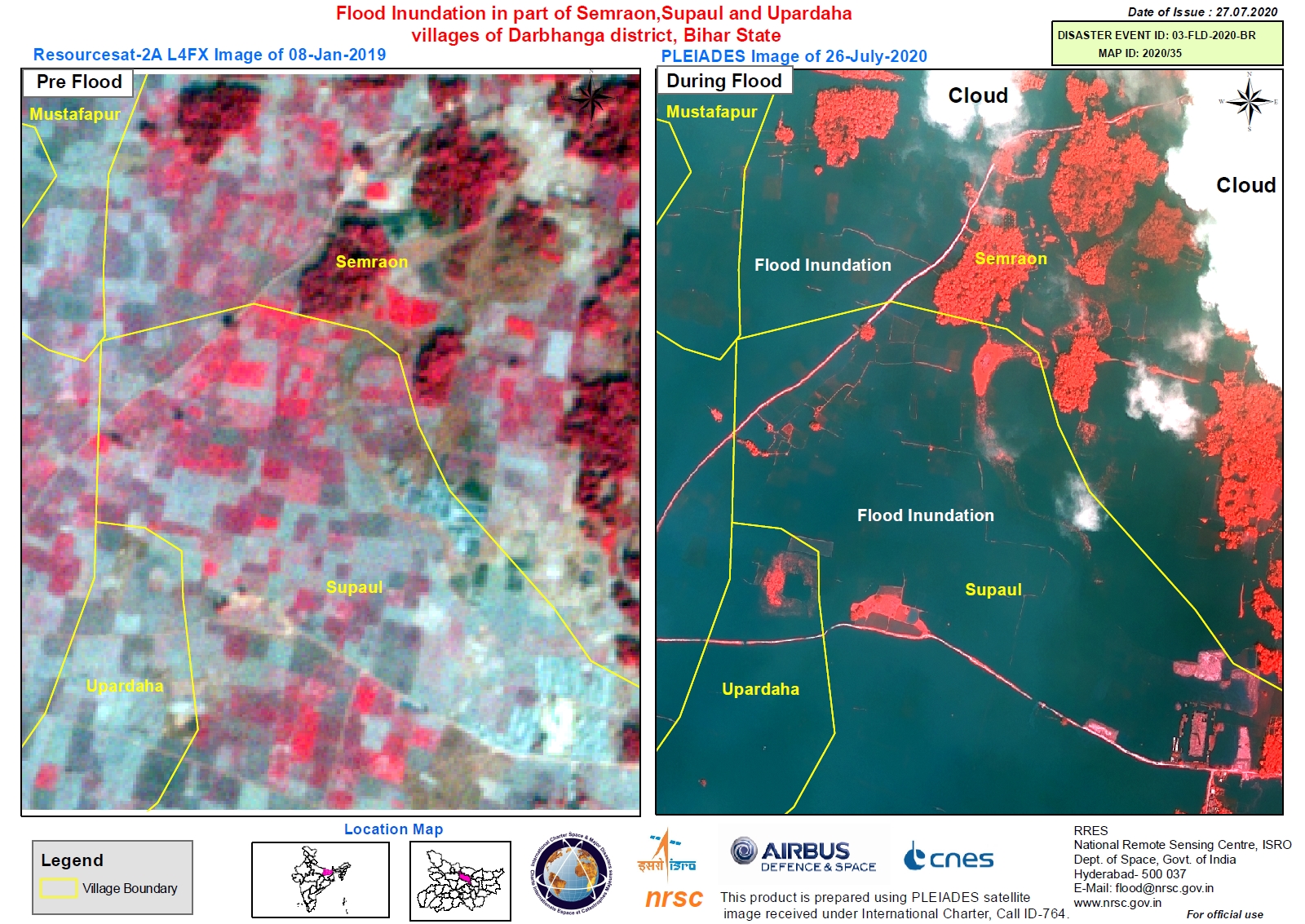
Flood inundation in part of Semraon, Supaul and Upardaha villages of Darbhanga district, Bihar State, India
版权: Pleiades © CNES (2020) - Distribution: Airbus Defence and Space, all rights reserved
ResourceSat-2 data and products © ISRO (2020) - All rights reserved
Map produced by NRSC/ISRO
Information about the Product
已获得: ResourceSat-2: 08/01/2019
Pleiades: 26/07/2020
源: ResourceSat-2 / Pleaides

Flood inundation in part of Shahzadpur, Mustafapur and Az Rakbe Basdeopur villages of Darbhanga district, Bihar State, India
版权: Pleiades © CNES (2020) - Distribution: Airbus Defence and Space, all rights reserved
ResourceSat-2 data and products © ISRO (2020) - All rights reserved
Map produced by NRSC/ISRO
Information about the Product
已获得: ResourceSat-2: 08/01/2019
Pleiades: 26/07/2020
源: ResourceSat-2 / Pleiades
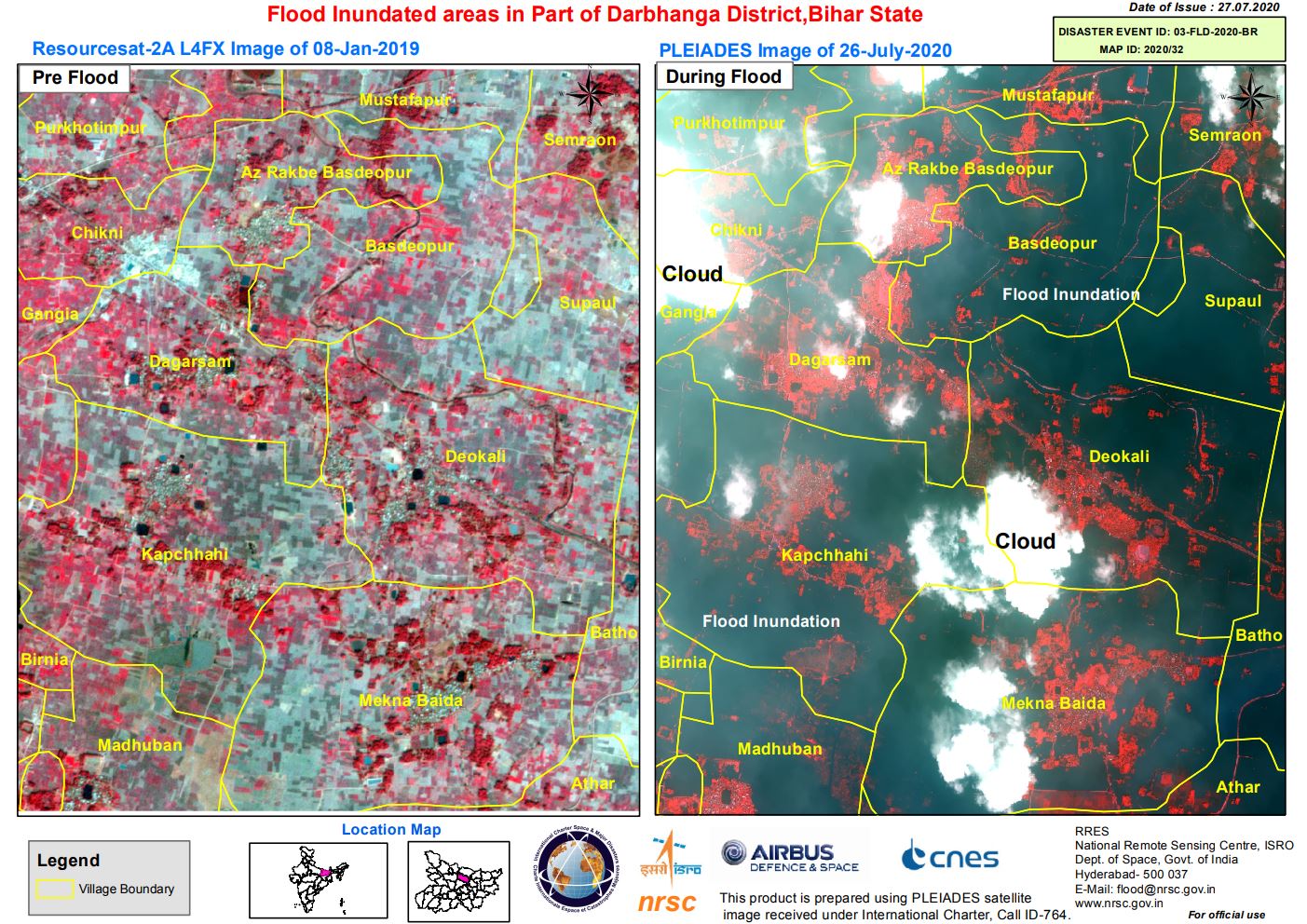
Flood inundated areas in part of Darbhanga District, Bihar State, India
版权: Pleiades © CNES (2020) - Distribution: Airbus Defence and Space, all rights reserved
ResourceSat-2 data and products © ISRO (2020) - All rights reserved
Map produced by NRSC/ISRO
Information about the Product
已获得: ResourceSat-2: 08/01/2020
Pleiades: 26/07/2020
源: ResourceSat-2 / Pleaides
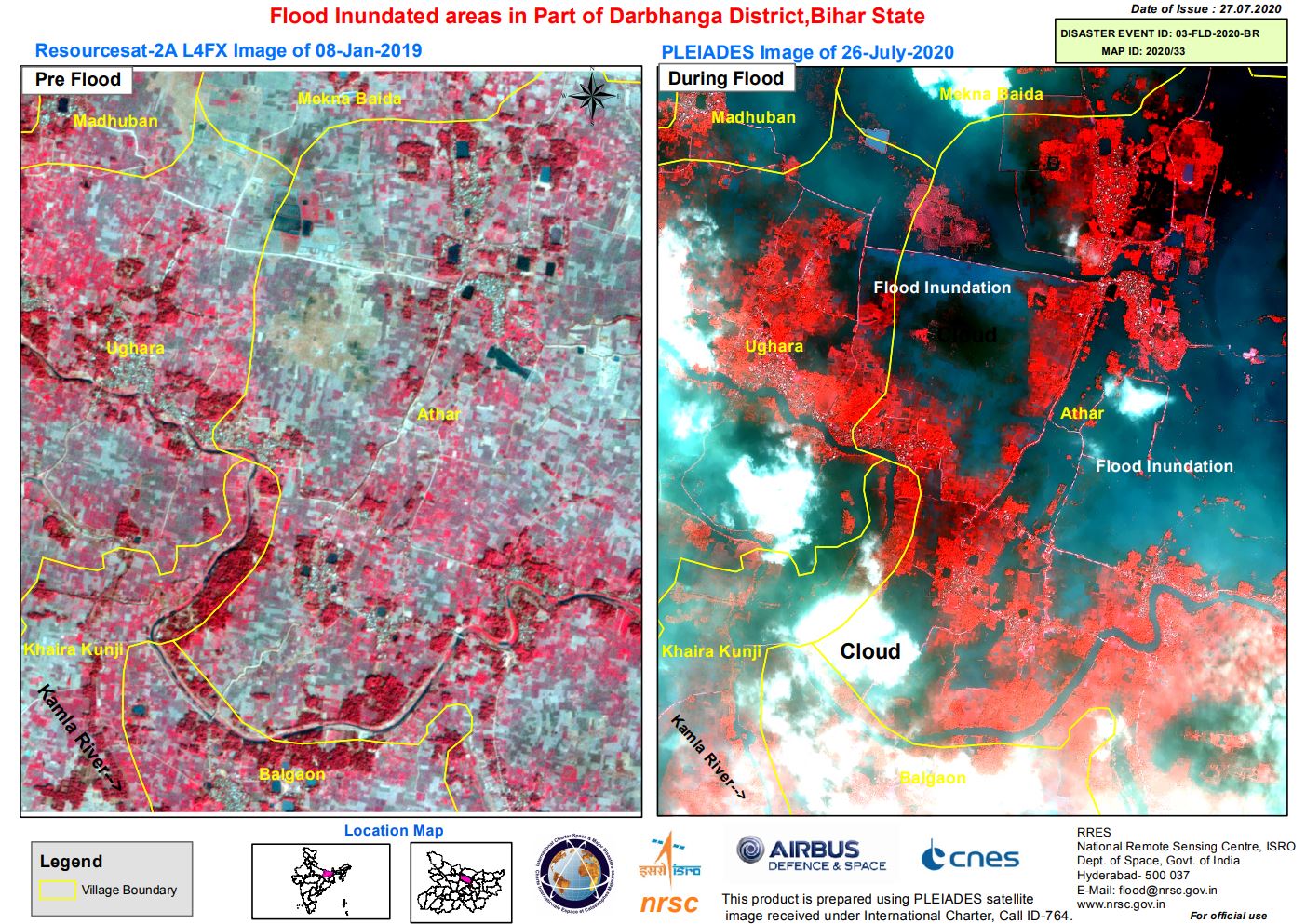
Flood Inundated areas in Part of Darbhanga District, Bihar State, India
版权: Pleiades © CNES (2020) - Distribution: Airbus Defence and Space, all rights reserved
ResourceSat-2 data and products © ISRO (2020) - All rights reserved
Map produced by NRSC/ISRO
Information about the Product
已获得: ResourceSat-2: 08/01/2019
Pleiades: 26/07/2020
源: ResourceSat-2
Pleaides
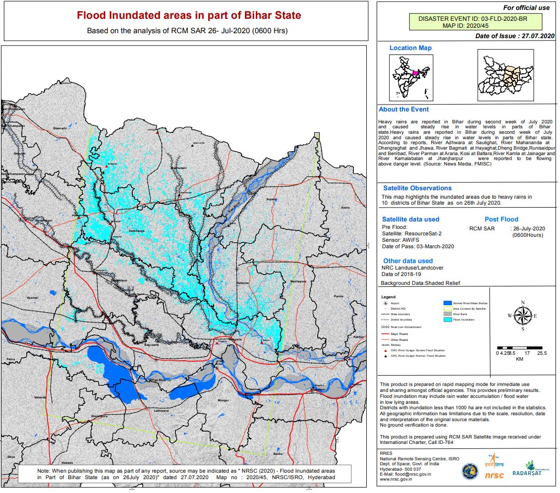
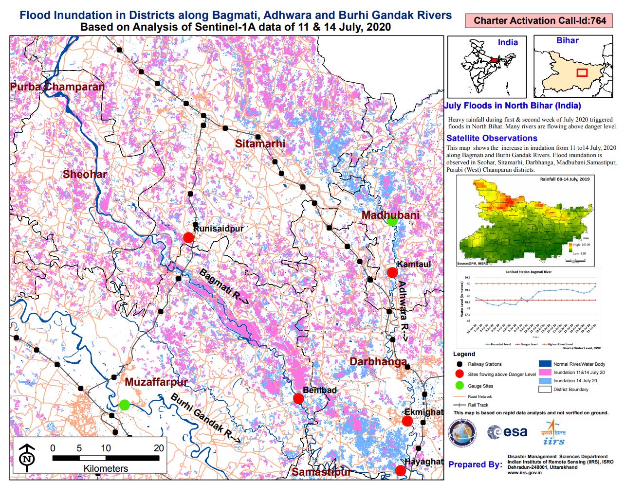
Flood Inundated areas in part of Bihar State, India
版权: RADARSAT Constellation Mission Imagery © Government of Canada (2020) - RADARSAT is an official mark of the Canadian Space
Agency
ResourceSat-2 data and products © ISRO (2020) - All rights reserved
Map produced by NRSC/ISRO
Information about the Product
已获得: ResourceSat-2: 08/01/2020
RCM: 26/07/2020
源: RCM / ResourceSat-2
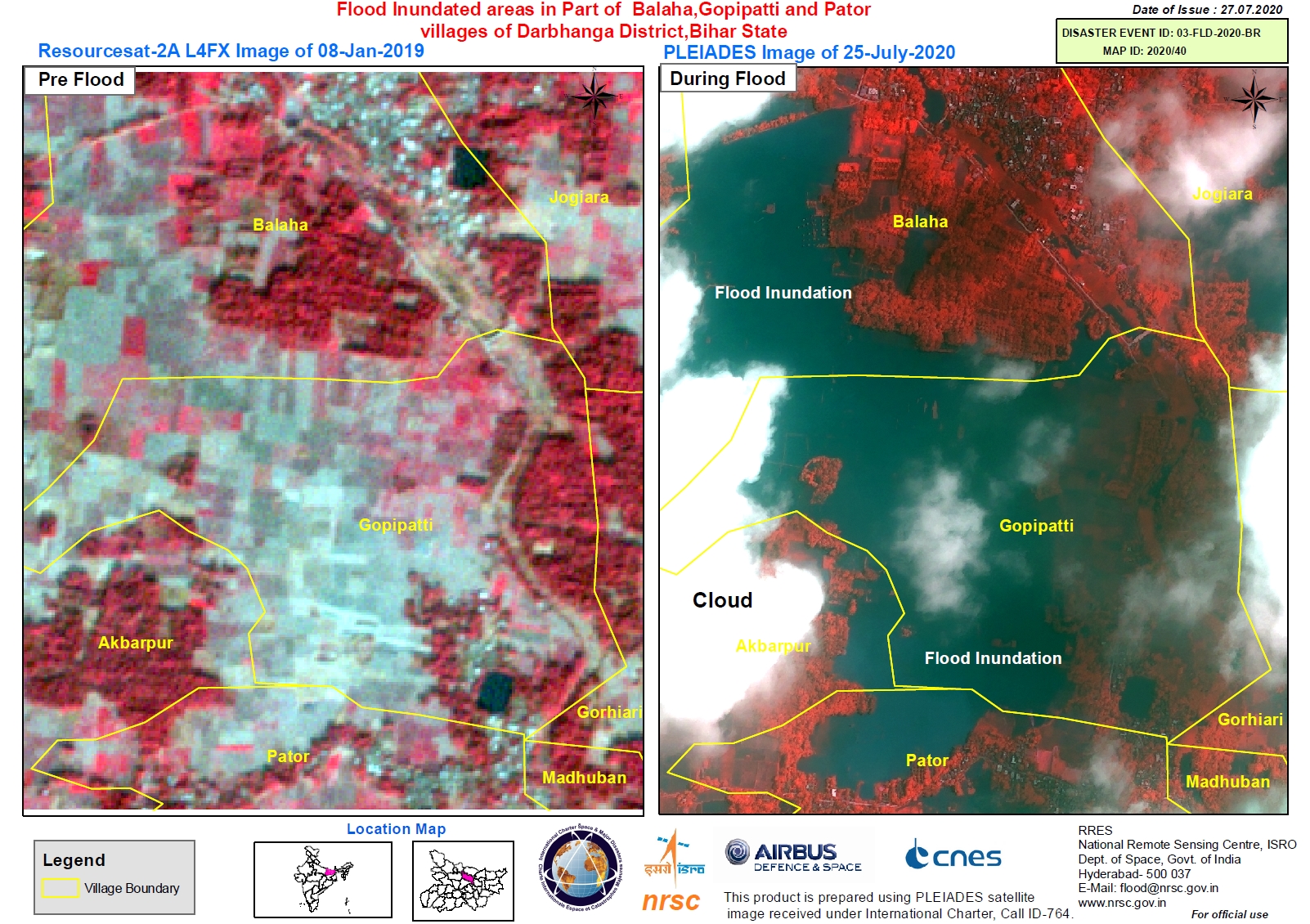
Flood Inundated areas in Part of Balaha, Gopipatti and Pator villages of Darbhanga District, Bihar State, India
版权: Pleiades © CNES (2020) - Distribution: Airbus Defence and Space, all rights reserved
ResourceSat-2 data and products © ISRO (2020) - All rights reserved
Map produced by NRSC/ISRO
Information about the Product
已获得: ResourceSat-2: 08/01/2019
Pleiades: 25/07/2020
源: ResourceSat-2 / Pleiades
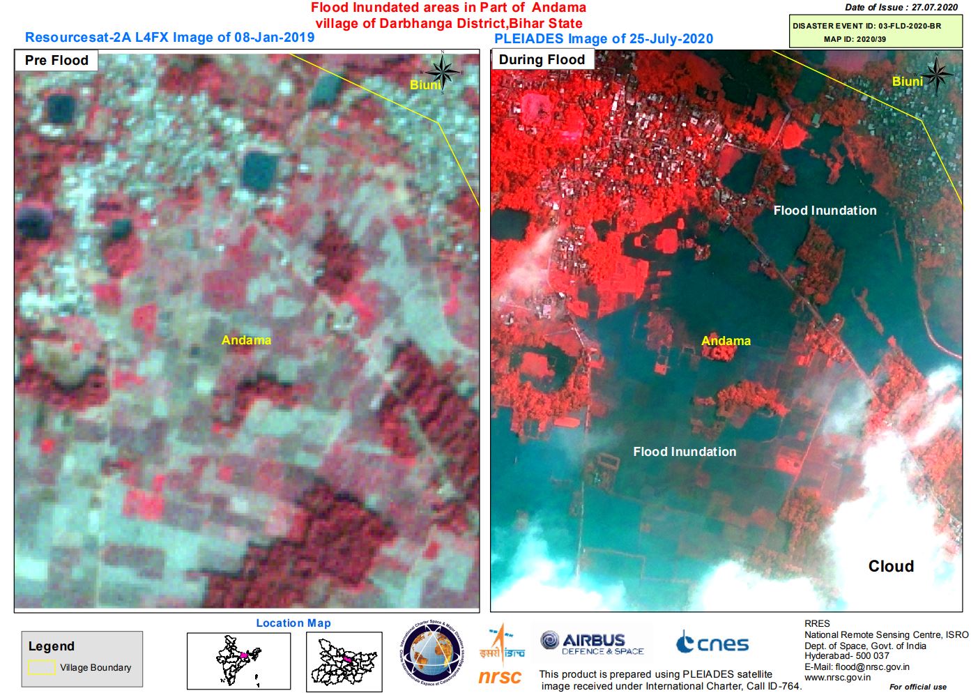
Flood Inundated areas in Part of Andama village of Darbhanga District, Bihar State, India
版权: Pleiades © CNES (2020) - Distribution: Airbus Defence and Space, all rights reserved
ResourceSat-2 data and products © ISRO (2020) - All rights reserved
Map produced by NRSC/ISRO
Information about the Product
已获得: Pleiades: 25/07/2020
ResourceSat-2: 08/01/2019
Map produced by NRSC/ISRO
源: ResourceSat-2 / Pleaides
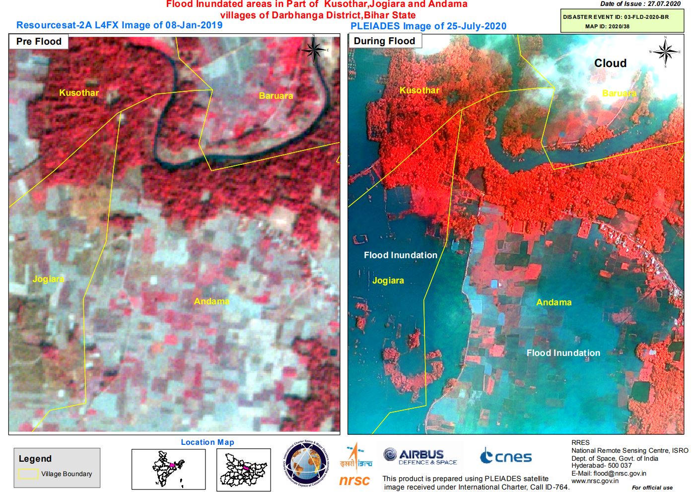
Flood Inundated areas in Part of Kusothar, Jogiara and Andama villages of Darbhanga District, Bihar State, India
版权: Pleiades © CNES (2020) - Distribution: Airbus Defence and Space, all rights reserved
ResourceSat-2 data and products © ISRO (2020) - All rights reserved
Map produced by NRSC/ISRO
Information about the Product
已获得: ResourceSat-2: 08/01/2019
Pleiades: 25/07/2020
源: ResourceSat-2 / Pleaides
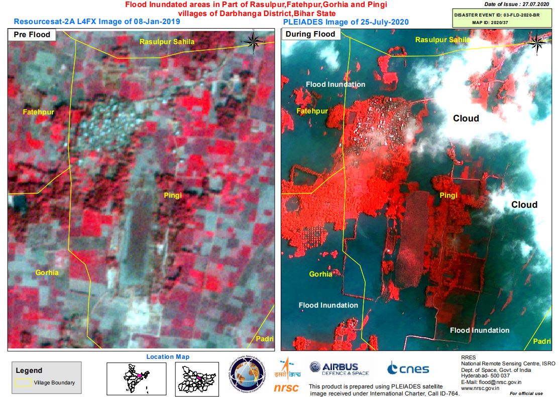
Flood Inundated areas in Part of Rasulpur, Fatehpur, Gorhia and Pingi villages of Darbhanga District, Bihar State, India
版权: Pleiades © CNES (2020) - Distribution: Airbus Defence and Space, all rights reserved
ResourceSat-2 data and products © ISRO (2020) - All rights reserved
Map produced by NRSC/ISRO
Information about the Product
已获得: ResourceSat-2: 08/01/2019
Pleiades: 25/07/2020
源: ResourceSat-2
Pleaides
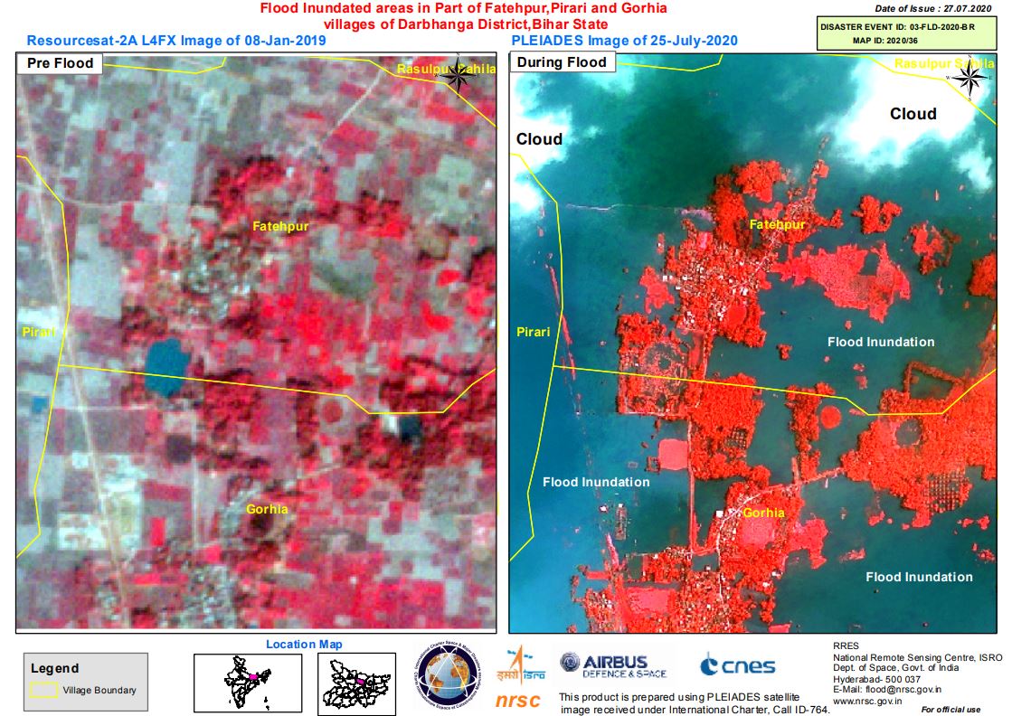
Flood Inundated areas in Part of Fatehpur, Pirari and Gorhia villages of Darbhanga District, Bihar State, India
版权: Pleiades © CNES (2020) - Distribution: Airbus Defence and Space, all rights reserved
ResourceSat-2 data and products © ISRO (2020) - All rights reserved
Map produced by NRSC/ISRO
Information about the Product
已获得: ResourceSat-2: 08/01/2020
Pleaides: 25/07/2020
源: ResourceSat-2 / Pleiades
Flood Inundated areas in part of Bihar State, India
版权: Contains modified Copernicus Sentinel data (2020)
RADARSAT Constellation Mission Imagery © Government of Canada (2020) - RADARSAT is an official mark of the Canadian Space Agency
ResourceSat-2 data and products © ISRO (2020) - All rights reserved
Map produced by NRSC/ISRO
Information about the Product
已获得: ResourceSat-2: 03/03/2020
RCM: 25/07/2020
Sentinel-1 26/07/2020
源: ResourceSat-2 / Sentinel-1 / RCM
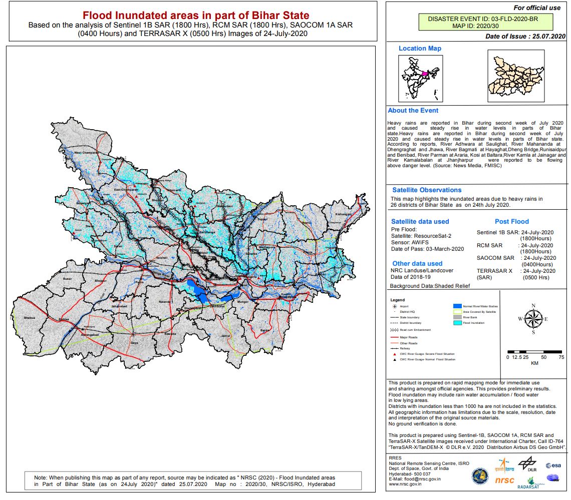
Flood Inundated areas in part of Bihar State India
版权: SAOCOM-1 © CONAE (2020)
Contains modified Copernicus Sentinel data (2020)
RADARSAT Constellation Mission Imagery © Government of Canada (2020) - RADARSAT is an official mark of the Canadian Space Agency
TerraSAR-X © DLR e.V. (2020), Distribution Airbus DS Geo GmbH
ResourceSat-2 data and products © ISRO (2020) - All rights reserved
Map produced by NRSC/ISRO
Information about the Product
已获得: ResourceSat-2: 03/03/2020
SAOCOM-1: 23/07/2020
Sentinel-1: 24/07/2020
RCM: 24/07/2020
TerraSAR-X: 23/07/2020
源: SAOCOM-1 / Sentinel-1 / RCM / TerraSAR-X / ResourceSat-2
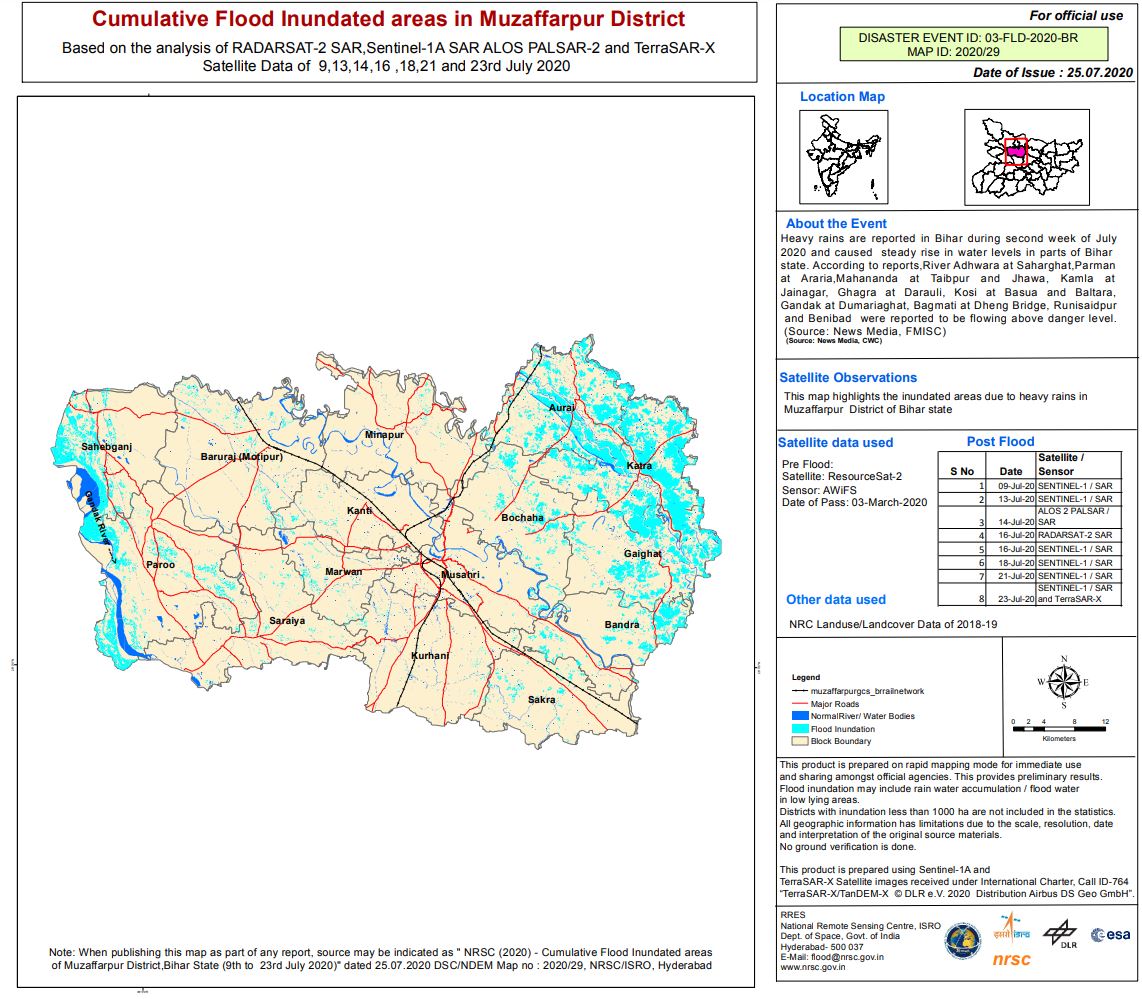
Cumulative Flood Inundated areas in Muzaffarpur District India
版权: Contains modified Copernicus Sentinel data (2020)
TerraSAR-X © DLR e.V. (2020), Distribution Airbus DS Geo GmbH
ALOS © JAXA (2018) All rights reserved
RADARSAT-2 Data and Products © Maxar Technologies Ltd. (2020) - All Rights Reserved. RADARSAT is an official trademark of the Canadian Space Agency.
ResourceSat-2 data and products © ISRO (2020) - All rights reserved
Map produced by NRSC/ISRO
Information about the Product
已获得: ResourceSat-2: 03/03/2020
Sentinel-1: 09/10/2020, 13/07/2020, 16/07/2020, 18/07/2020, 21/07/2020 & 23/07/2020
ALOS-2: 14/07/2020
RADARSAT-2: 16/07/2020
TerraSAR-X: 23/07/2020
源: ResourceSat-2
Sentinel-1
RADARSAT-2
TerraSAR-X
ALOS-2
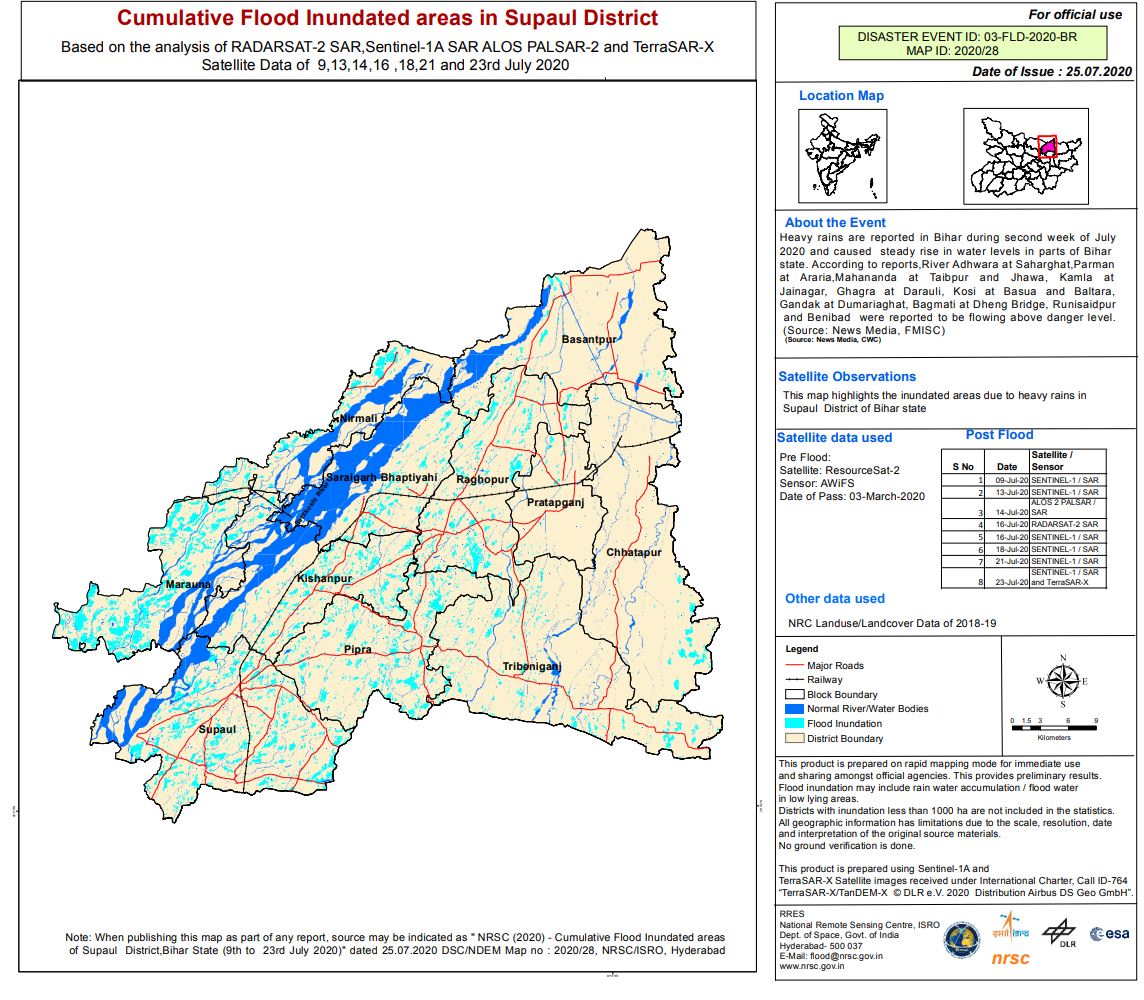
Cumulative Flood Inundated areas in Supaul District India
版权: Contains modified Copernicus Sentinel data (2020)
TerraSAR-X © DLR e.V. (2020), Distribution Airbus DS Geo GmbH
ALOS © JAXA (2018) All rights reserved
RADARSAT-2 Data and Products © Maxar Technologies Ltd. (2020) - All Rights Reserved. RADARSAT is an official trademark of the Canadian Space Agency.
ResourceSat-2 data and products © ISRO (2020) - All rights reserved
Map produced by NRSC/ISRO
Information about the Product
已获得: ResourceSat-2: 03/03/2020
Sentinel-1: 09/10/2020, 13/07/2020, 16/07/2020, 18/07/2020, 21/07/2020 & 23/07/2020
ALOS-2: 14/07/2020
RADARSAT-2: 16/07/2020
TerraSAR-X: 23/07/2020
源: ResourceSat-2
Sentinel-1
RADARSAT-2
TerraSAR-X
ALOS-2
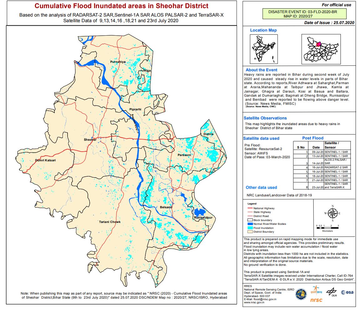
Cumulative Flood Inundated areas in Sheohar District India
版权: Contains modified Copernicus Sentinel data (2020)
TerraSAR-X © DLR e.V. (2020), Distribution Airbus DS Geo GmbH
ALOS © JAXA (2018) All rights reserved
RADARSAT-2 Data and Products © Maxar Technologies Ltd. (2020) - All Rights Reserved. RADARSAT is an official trademark of the Canadian Space Agency.
ResourceSat-2 data and products © ISRO (2020) - All rights reserved
Map produced by NRSC/ISRO
Information about the Product
已获得: Resource-2: 03/03/2020
Sentinel-1: 09/10/2020, 13/07/2020, 16/07/2020, 18/07/2020, 21/07/2020 & 23/07/2020
ALOS-2: 14/07/2020
RADARSAT-2: 16/07/2020
TerraSAR-X: 23/07/2020
源: ResourceSat-2
Sentinel-1
RADARSAT-2
TerraSAR-X
ALOS-2

Cumulative Flood Inundated areas in Sitamarhi District India
版权: Contains modified Copernicus Sentinel data (2020)
TerraSAR-X © DLR e.V. (2020), Distribution Airbus DS Geo GmbH
ALOS © JAXA (2018) All rights reserved
RADARSAT-2 Data and Products © Maxar Technologies Ltd. (2020) - All Rights Reserved. RADARSAT is an official trademark of the Canadian Space Agency.
ResourceSat-2 data and products © ISRO (2020) - All rights reserved
Map produced by NRSC/ISRO
Information about the Product
已获得: ResourceSat-2: 03/03/2020
Sentinel-1: 09/10/2020, 13/07/2020, 16/07/2020, 18/07/2020, 21/07/2020 & 23/07/2020
ALOS-2: 14/07/2020
RADARSAT-2: 16/07/2020
TerraSAR-X: 23/07/2020
源: ResourceSat-2
Sentinel-1
RADARSAT-2
TerraSAR-X
ALOS-2
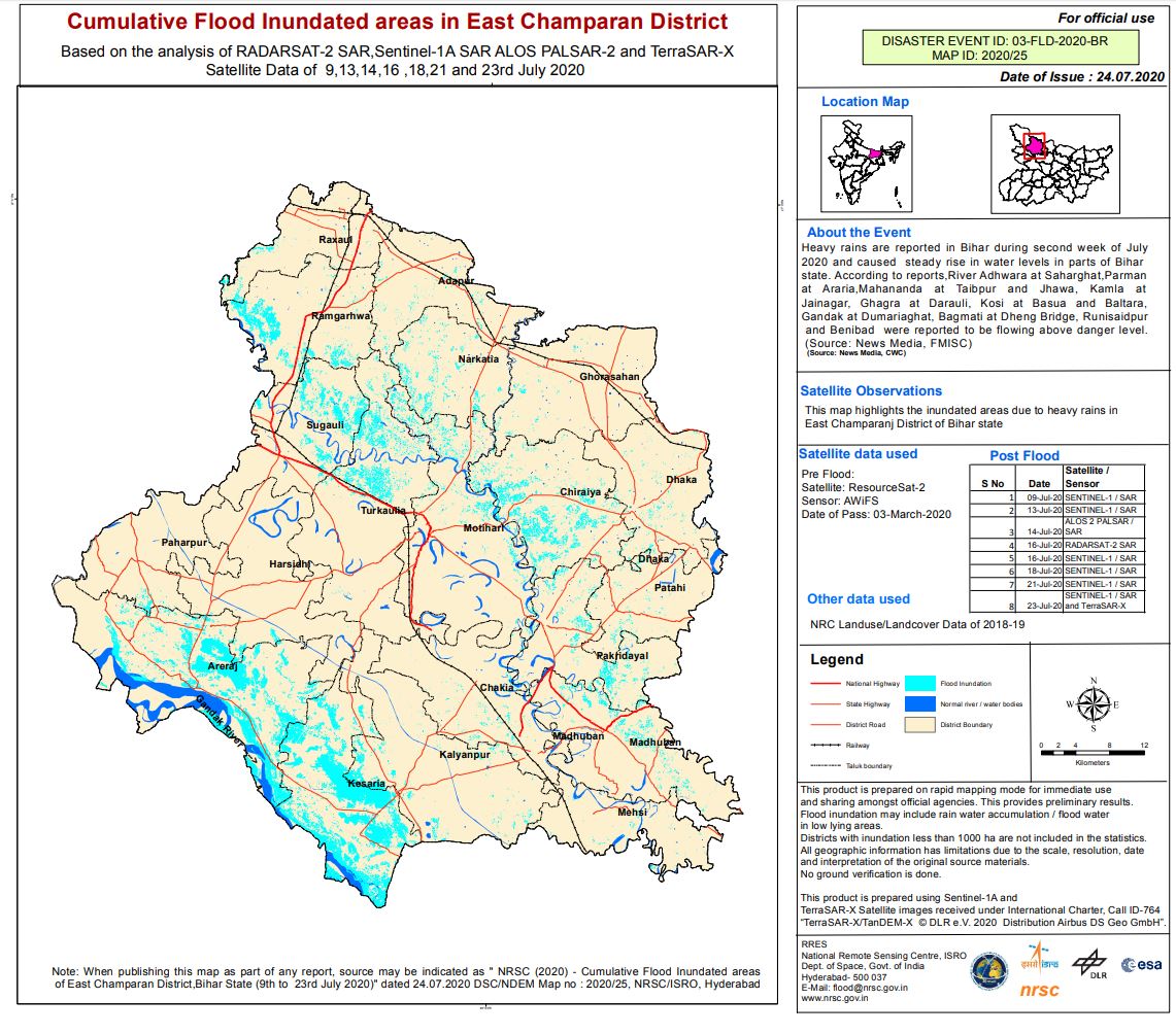
Cumulative Flood Inundated areas in East Champaran District, India
版权: Contains modified Copernicus Sentinel data (2020)
© DLR e.V. (2020), Distribution Airbus DS Geo GmbH
ALOS © JAXA (2018) All rights reserved
RADARSAT-2 Data and Products © Maxar Technologies Ltd. (2020) - All Rights Reserved. RADARSAT is an official trademark of the Canadian Space Agency.
ResourceSat-2 data and products © ISRO (2020) - All rights reserved
Map produced by NRSC/ISRO
Information about the Product
已获得: ResourceSat-2: 03/03/2020
Sentinel-1: 09/10/2020, 13/07/2020, 16/07/2020, 18/07/2020, 21/07/2020 & 23/07/2020
ALOS-2: 14/07/2020
RADARSAT-2: 16/07/2020
TerraSAR-X: 23/07/2020
源: ResourceSat-2
Sentinel-1
RADARSAT-2
TerraSAR-X
ALOS-2
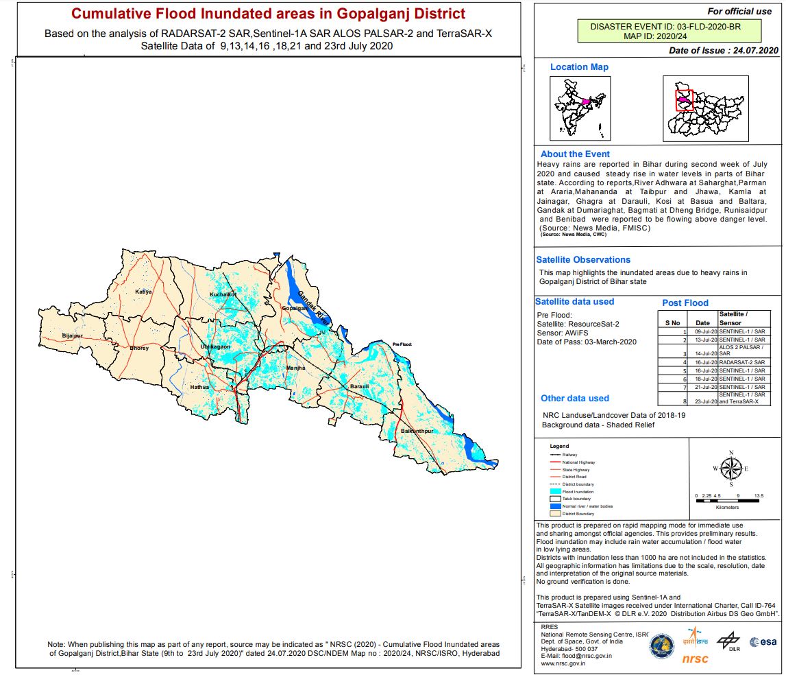
Cumulative Flood Inundated areas in Gopalganj District, India
版权: Contains modified Copernicus Sentinel data (2020)
© DLR e.V. (2020), Distribution Airbus DS Geo GmbH
ALOS © JAXA (2018) All rights reserved
RADARSAT-2 Data and Products © Maxar Technologies Ltd. (2020) - All Rights Reserved. RADARSAT is an official trademark of the Canadian Space Agency.
ResourceSat-2 data and products © ISRO (2020) - All rights reserved
Information about the Product
已获得: ResourceSat-2: 03/03/2020
Sentinel-1: 09/10/2020, 13/07/2020, 16/07/2020, 18/07/2020, 21/07/2020 & 23/07/2020
ALOS-2: 14/07/2020
RADARSAT-2: 16/07/2020
TerraSAR-X: 23/07/2020
源: ResourceSat-2
Sentinel-1
RADARSAT-2
TerraSAR-X
ALOS-2
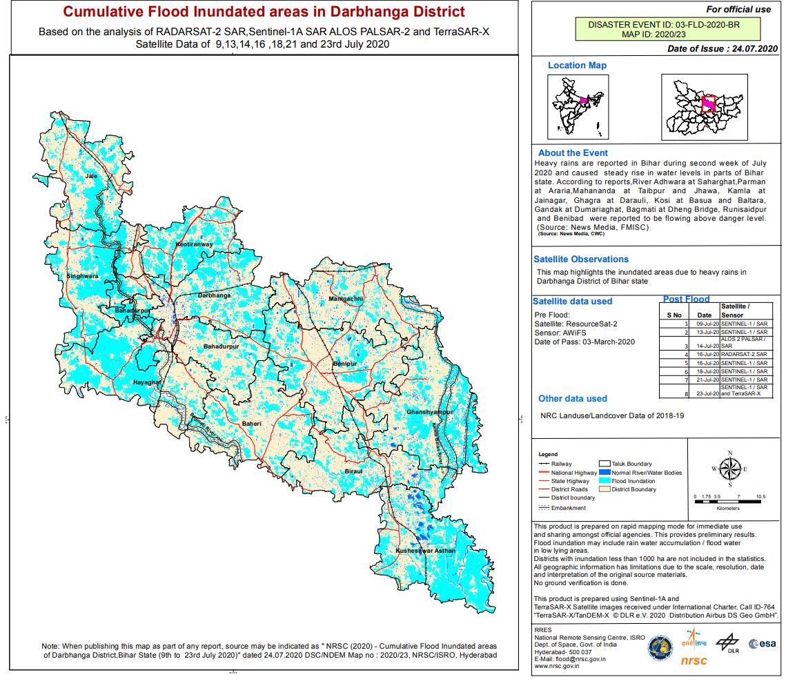
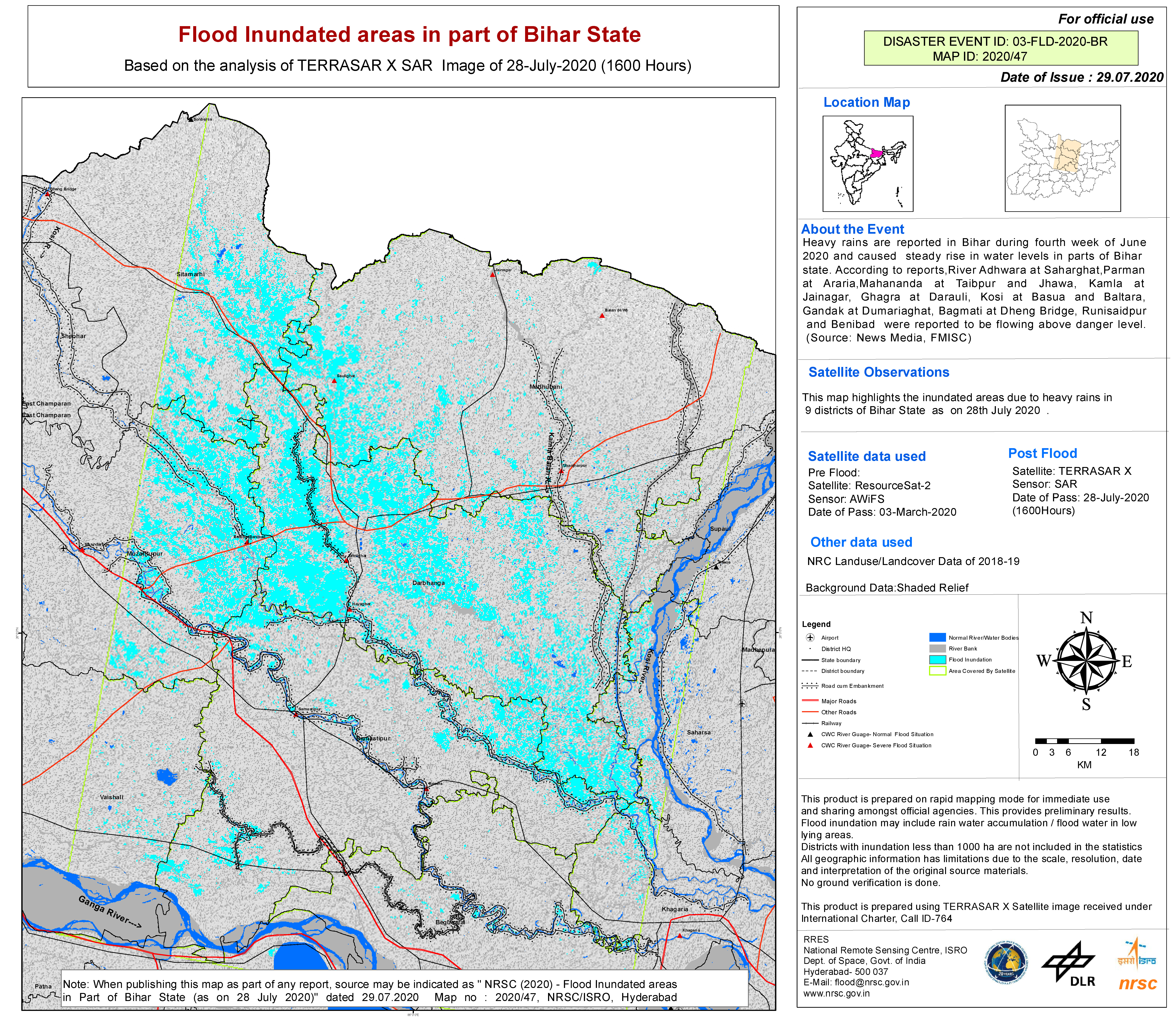
Cumulative Flood Inundated areas in Darbhanga District India
版权: Contains modified Copernicus Sentinel data (2020)
© DLR e.V. (2020), Distribution Airbus DS Geo GmbH
ResourceSat-2 data and products © ISRO (2020) - All rights reserved
RADARSAT-2 Data and Products © Maxar Technologies Ltd. (2020) - All Rights Reserved. RADARSAT is an official trademark of the Canadian Space Agency.
Map produced by NRSC/ISRO
Information about the Product
已获得: Sentinel-1: 09/07/2020, 13/07/2020, 16/07/2020, 18/07/2020, 21/07/2020 & 23/07/2020
ALOS-2: 14/07/2020
RADARSAT-2: 16/07/2020
TerraSAR-X: 23/07/2020
源: Sentinel-1
TerraSAR-X
ALOS-2
RADARSAT-2
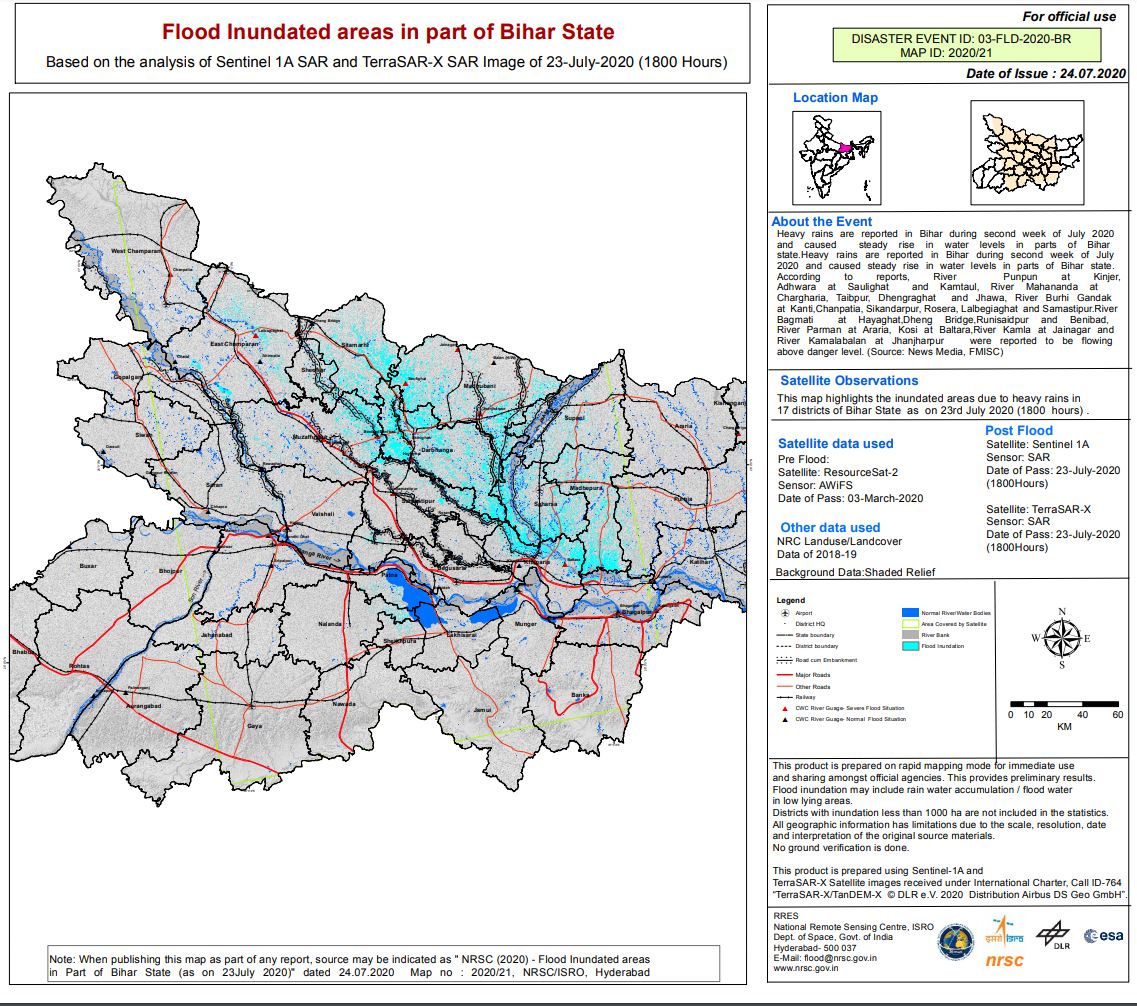
Flood Inundation area in part of Bihar State, India
版权: © DLR e.V. (2020), Distribution Airbus DS Geo GmbH
Contains modified Copernicus Sentinel data (2020)
Map Created by NRSC/ISRO
RADARSAT-2 Data and Products © Maxar Technologies Ltd. (2020) - All Rights Reserved. RADARSAT is an official trademark of the Canadian Space Agency.
ALOS © JAXA (2018) All rights reserved
Map produced by NRSC/ISRO
Information about the Product
已获得: TerrSAR-X: 23/07/2020
Sentinel-1:09/07/2020, 13/07/2020, 16/07/2020, 18/07/2020, 21/07/2020 & 23/07/2020
ALOS-2: 14/07/2020
RADARSAT-2:16/07/2020
源: Sentinel-1
TerraSAR-X
ALOS-2
RADARSAT-2
 返回完整的响应档案

