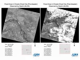
Charter activations
Flooding in Argentina
Heavy rains caused rivers in the Chubut, Neuquén and Río Negro regions in Argentina to flood, threatening dams downstream. The Argentinian National Weather Service issued an alert on 27 July 2006.
| Type of Event: | Flooding |
| Location of Event: | Choele-Choel City and Neuquen City, Argentina |
| Date of Charter Activation: | 27/07/2006 |
| Charter Requestor: | SIFEM Argentina |
| Project Management: | CONAE |
Products

Radarsat 30/07/2006
Copyright: CSA 2006 Image processing, map created 30/07/2006 by INA (National Water Institute of Argentina). Image processing and information extraction by CONAE (Argentina Space Agency). Analysis and map creation by INA in the framework of International Charter Space and Major Disasters.
12.5m resolution
Information about the Product
Acquired: 30/07/2006
Source: RADARSAT-1

Spot Change Detection Choele Choel
Copyright: CNES 2006 Image processing, map created 04/08/2006 by INA (National Water Institute of Argentina). Image processing and information extraction by CONAE (Argentina Space Agency). Analysis and map creation by INA in the framework of International Charter Space and Major Disasters.
10m resolution
Information about the Product
Acquired: 29/07/2006, 08/08/2003
Source: Spot 5
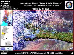
IRS-IP6 Neuquen-Rio Negro-30/07/2006
Copyright: ISRO 2006 Image processing, map created 06/08/2006 by INA (National Water Institute of Argentina). Image processing and information extraction by CONAE (Argentina Space Agency). Analysis and map creation by INA in the framework of International Charter Space and Major Disasters.
56m resolution
Information about the Product
Acquired: 30/07/2006
Source: IRS-P6 (AWIFS)

Spot/Formosat-2: General Conesa 14/08/2006 Combined scale 1:50,000
Copyright: CNES 2006; NSPO Taiwan 2006 Image processing, map created 23/08/2006 by INA (National Water Institute of Argentina). Image processing and information extraction by CONAE (Argentina Space Agency). Analysis and map creation by INA in the framework of International Charter Space and Major Disasters.
2m resolution
Information about the Product
Acquired: 14/08/2006
Source: Spot/Formosat-2

IRS-IP6 General Roca-30/07/2006
Copyright: ISRO 2006 Image processing, map created 06/08/2006 by INA (National Water Institute of Argentina). Image processing and information extraction by CONAE (Argentina Space Agency). Analysis and map creation by INA in the framework of International Charter Space and Major Disasters.
56m resolution
Information about the Product
Acquired: 30/07/2006
Source: IRS-P6 (AWIFS)

Spot/Formosat-2: 16/08/2006 scale 1:120,000 General View
Copyright: CNES 2006; NSPO Taiwan 2006 Image processing, map created 23/08/2006 by INA (National Water Institute of Argentina). Image processing and information extraction by CONAE (Argentina Space Agency). Analysis and map creation by INA in the framework of International Charter Space and Major Disasters.
2m resolution
Information about the Product
Acquired: 16/08/2006
Source: Spot/Formosat-2

Spot/Formosat-2: 16/08/2006 Downstream Detail
Copyright: CNES 2006; NSPO Taiwan 2006 Image processing, map created 23/08/2006 by INA (National Water Institute of Argentina). Image processing and information extraction by CONAE (Argentina Space Agency). Analysis and map creation by INA in the framework of International Charter Space and Major Disasters.
2m resolution
Information about the Product
Acquired: 16/08/2006
Source: Spot/Formosat-2

IRS-IP6 Choele Choel 30/07/2006
Copyright: ISRO 2006 Image processing, map created 06/08/2006 by INA (National Water Institute of Argentina). Image processing and information extraction by CONAE (Argentina Space Agency). Analysis and map creation by INA in the framework of International Charter Space and Major Disasters.
56m resolution
Information about the Product
Acquired: 30/07/2006
Source: IRS-P6 (AWIFS)

RADARSAT SPOT-5 Merged, 12.5m, 2.5m resolution
Copyright: CSA 2006
CNES 2006
Image processing, map created 30/07/2006 by INA (National Water Institute of Argentina).
Image processing and information extraction by CONAE (Argentina Space Agency).
Analysis and map creation by INA in the framework of International Charter Space and Major Disasters.
12.5m, 2.5m resolution
Information about the Product
Acquired: 30/07/2006
Source: RADARSAT-1, SPOT-5

Spot/Formosat-2: 16/08/2006 Upstream Detail
Copyright: CNES 2006; NSPO Taiwan 2006 Image processing, map created 23/08/2006 by INA (National Water Institute of Argentina). Image processing and information extraction by CONAE (Argentina Space Agency). Analysis and map creation by INA in the framework of International Charter Space and Major Disasters.
2m resolution
Information about the Product
Acquired: 16/08/2006
Source: Spot/Formosat-2

Spot/Formosat-2: 16/08/2006 Shoreline Detail
Copyright: CNES 2006; NSPO Taiwan 2006 Image processing, map created 23/08/2006 by INA (National Water Institute of Argentina). Image processing and information extraction by CONAE (Argentina Space Agency). Analysis and map creation by INA in the framework of International Charter Space and Major Disasters
2m resolution
Information about the Product
Acquired: 16/08/2006
Source: Spot/Formosat-2
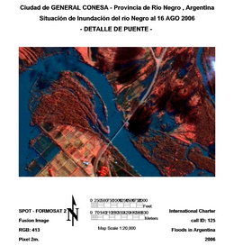
Spot/Formosat-2: 16/08/2006 Bridge Detail
Copyright: CNES 2006; NSPO Taiwan 2006 Image processing, map created 23/08/2006 by INA (National Water Institute of Argentina). Image processing and information extraction by CONAE (Argentina Space Agency). Analysis and map creation by INA in the framework of International Charter Space and Major Disasters.
2m resolution
Information about the Product
Acquired: 16/08/2006
Source: Spot/Formosat-2

Spot/Formosat-2: General Conesa 16/08/2006 Combined scale 1:50,000
Copyright: CNES 2006; NSPO Taiwan 2006 Image processing, map created 23/08/2006 by INA (National Water Institute of Argentina). Image processing and information extraction by CONAE (Argentina Space Agency). Analysis and map creation by INA in the framework of International Charter Space and Major Disasters.
2m resolution
Information about the Product
Acquired: 16/08/2006
Source: Spot/Formosat-2

Spot/Formosat-2: General Conesa 16/08/2006 Overview
Copyright: CNES 2006; NSPO Taiwan 2006 Image processing, map created 23/08/2006 by INA (National Water Institute of Argentina). Image processing and information extraction by CONAE (Argentina Space Agency). Analysis and map creation by INA in the framework of International Charter Space and Major Disasters.
2m resolution
Information about the Product
Acquired: 16/08/2006
Source: Spot/Formosat-2

Rio Negro Spot/Formosat-2: 14/08/2006 scale 1:15,000
Copyright: CNES 2006; NSPO Taiwan 2006 Image processing, map created 23/08/2006 by INA (National Water Institute of Argentina). Image processing and information extraction by CONAE (Argentina Space Agency). Analysis and map creation by INA in the framework of International Charter Space and Major Disasters.
2m resolution
Information about the Product
Acquired: 14/08/2006
Source: Spot/Formosat-2

Rio Negro Spot/Formosat-2: 14/08/2006 scale 1:50,000
Copyright: CNES 2006; NSPO Taiwan 2006 Image processing, map created 23/08/2006 by INA (National Water Institute of Argentina). Image processing and information extraction by CONAE (Argentina Space Agency). Analysis and map creation by INA in the framework of International Charter Space and Major Disasters.
2m resolution
Information about the Product
Acquired: 14/08/2006
Source: Spot/Formosat-2
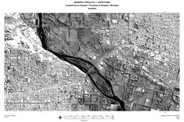
Spot/Formosat-2: Rio Neuquen 01/08/2006 scale 1:25,000
Copyright: CNES 2006; NSPO Taiwan 2006 Image processing, map created 04/08/2006 by INA (National Water Institute of Argentina). Image processing and information extraction by CONAE (Argentina Space Agency). Analysis and map creation by INA in the framework of International Charter Space and Major Disasters.
2m resolution
Information about the Product
Acquired: 01/08/2006
Source: Spot/Formosat-2

Spot/Formosat-2: Choele Choel 01/08/2006 Panchromatic image scale 1:10,000
Copyright: CNES 2006; NSPO Taiwan 2006 Image processing, map created 04/08/2006 by INA (National Water Institute of Argentina). Image processing and information extraction by CONAE (Argentina Space Agency). Analysis and map creation by INA in the framework of International Charter Space and Major Disasters.
2m resolution
Information about the Product
Acquired: 01/08/2006
Source: Spot/Formosat-2

Spot/Formosat-2: Choele Choel 01/08/2006 scale 1:125,000
Copyright: CNES 2006; NSPO Taiwan 2006 Image processing, map created 04/08/2006 by INA (National Water Institute of Argentina). Image processing and information extraction by CONAE (Argentina Space Agency). Analysis and map creation by INA in the framework of International Charter Space and Major Disasters.
10m resolution
Information about the Product
Acquired: 01/08/2006
Source: Spot/Formosat-2

Spot/Formosat-2: Neuquen-Cipolletti 01/08/2006 scale 1:125,000
Copyright: CNES 2006; NSPO Taiwan 2006 Image processing, map created 04/08/2006 by INA (National Water Institute of Argentina). Image processing and information extraction by CONAE (Argentina Space Agency). Analysis and map creation by INA in the framework of International Charter Space and Major Disasters.
2m resolution
Information about the Product
Acquired: 01/08/2006
Source: Spot/Formosat-2

Spot/Formosat-2: Choele Choel 01/08/2006 scale 1:25,000
Copyright: CNES 2006; NSPO Taiwan 2006 Image processing, map created 04/08/2006 by INA (National Water Institute of Argentina). Image processing and information extraction by CONAE (Argentina Space Agency). Analysis and map creation by INA in the framework of International Charter Space and Major Disasters.
10m resolution
Information about the Product
Acquired: 01/08/2006
Source: Spot/Formosat-2

Spot/Formosat-2: Confluence 01/08/2006 Panchromatic image scale 1:25,000
Copyright: CNES 2006; NSPO Taiwan 2006 Image processing, map created 04/08/2006 by INA (National Water Institute of Argentina). Image processing and information extraction by CONAE (Argentina Space Agency). Analysis and map creation by INA in the framework of International Charter Space and Major Disasters.
2m resolution
Information about the Product
Acquired: 01/08/2006
Source: Spot/Formosat-2

Spot/Formosat-2: Neuquen-Cipolletti 01/08/2006 scale 1:75,000
Copyright: CNES 2006; NSPO Taiwan 2006 Image processing, map created 04/08/2006 by INA (National Water Institute of Argentina). Image processing and information extraction by CONAE (Argentina Space Agency). Analysis and map creation by INA in the framework of International Charter Space and Major Disasters.
2m resolution
Information about the Product
Acquired: 01/08/2006
Source: Spot/Formosat-2

Spot/Formosat-2: Neuquen Limay River 01/08/2006 Panchromatic image scale 1:25,000
Copyright: CNES 2006; NSPO Taiwan 2006 Image processing, map created 04/08/2006 by INA (National Water Institute of Argentina). Image processing and information extraction by CONAE (Argentina Space Agency). Analysis and map creation by INA in the framework of International Charter Space and Major Disasters.
2m resolution
Information about the Product
Acquired: 01/08/2006
Source: Spot/Formosat-2
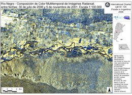
Radarsat Change Detection 30/07/2006
Copyright: CSA 2006 Image processing, map created 30/07/2006 by INA (National Water Institute of Argentina). Image processing and information extraction by CONAE (Argentina Space Agency). Analysis and map creation by INA in the framework of International Charter Space and Major Disasters.
12.5m resolution
Information about the Product
Acquired: 30/07/2006
Source: RADARSAT-1
 Back to the full activation archive

 English
 Spanish
 French
 Chinese
 Russian
 Portuguese

