 English
 Spanish
 French
 Chinese
 Russian
 Portuguese
 Mount Ruang volcano eruption in Indonesia
Mount Ruang volcano eruption in Indonesia
Charter activations
Mount Ruang volcano eruption in Indonesia
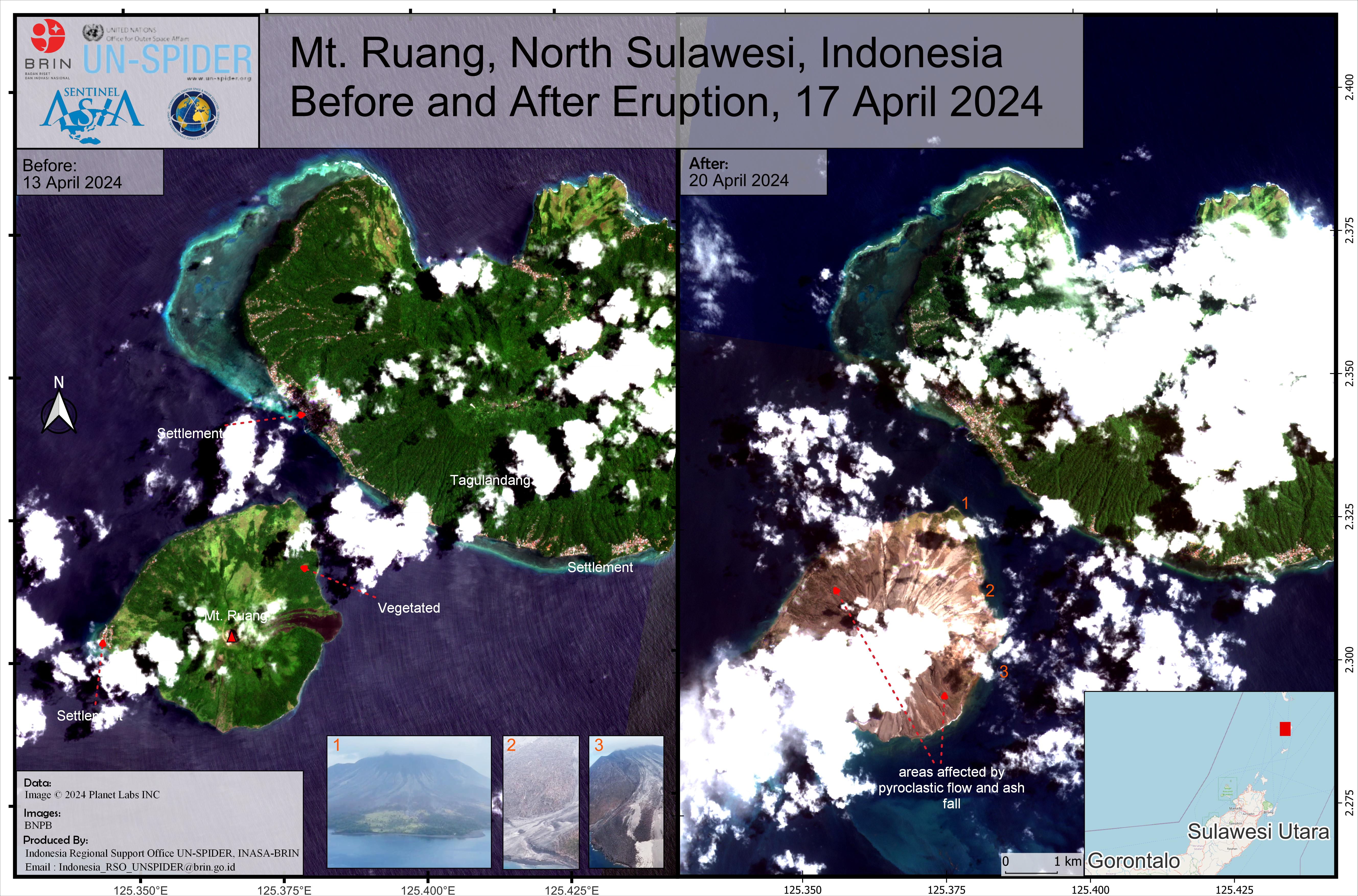
Mount Ruang, the southernmost stratovolcano in the Sangihe Islands arc, North Sulawesi, Indonesia had at least five large eruptions on 17 April, causing the Center for Volcanology and Geological Disaster Mitigation to issue its highest-level alert, indicating an active eruption.
Indonesian authorities issued a tsunami alert Wednesday after the eruptions, the worry is that part of the volcano could collapse into the sea and cause a tsunami amid fears of a repeat of the 1871 disaster.
There have been no reports of deaths or injuries so far but residents from nearby areas, including the remote island of Tagulandang, home to around 20,000 have been advised to evacuate and a local provinicial airport has been forced to close.
In 2018 the eruption of Indonesia's Anak Krakatau volcano caused a tsunami along the coasts of Sumatra and Java after parts of the mountain fell into the ocean, killing 430 people.
Related Resources:
Sentinel Asia activation for Mount Ruang eruption| Место события: | Indonesia |
| Date of Charter Activation: | 2024-04-19 |
| Время активации Хартии: | 10:16 |
| TЧасовой пояс в районе активации Хартии: | UTC+09:00 |
| Запрос на активацию поступил от: | ADRC on behalf of National Research and Innovation Agency (BRIN) |
| Номер активации: | 873 |
| Менеждер проекта от: | Virgilius Rivan Seran (National Research and Innovation Agency (BRIN)) |
| act-value-adders: | Julie Griswold (USGS) National Research and Innovation Agency (BRIN) National Agency for Disaster Countermeasure (BNPB) Shiro KAWAKITA (JAXA) Michael Budde (USGS) |
Products
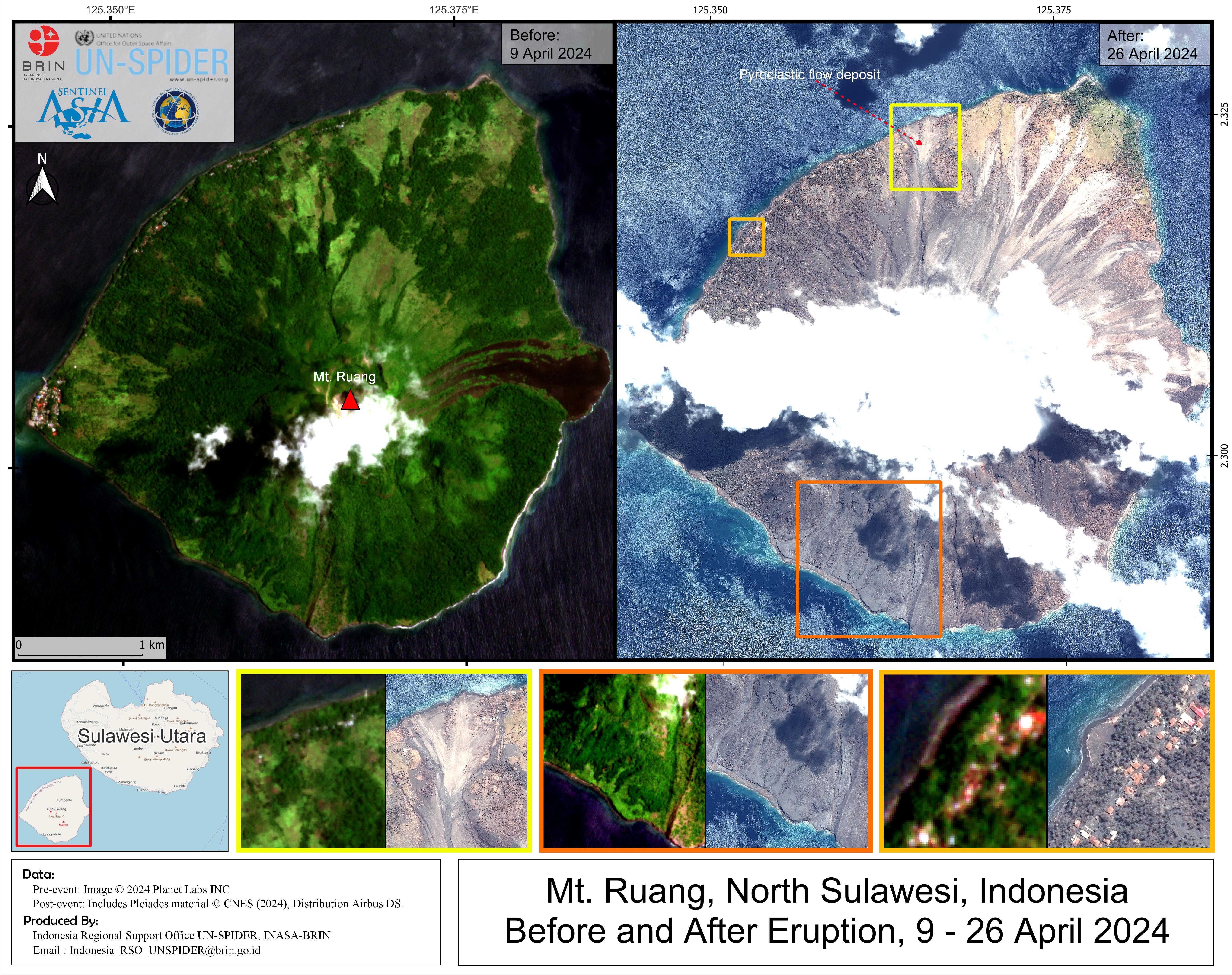
Mt. Ruang, North Sulawesi, Indonesia Before and After Eruption
Авторские права: Includes Pleiades material © CNES (2024), Distribution Airbus DS.
PlanetScope © Planet Labs Inc. (2024)
Map produced by UN-SPIDER
Information about the Product
Получено: Pleiades: 26/04/2024
PlanetScope: 13/04/2024
Источник: Pleiades, PlanetScope
Категория: Reference Map
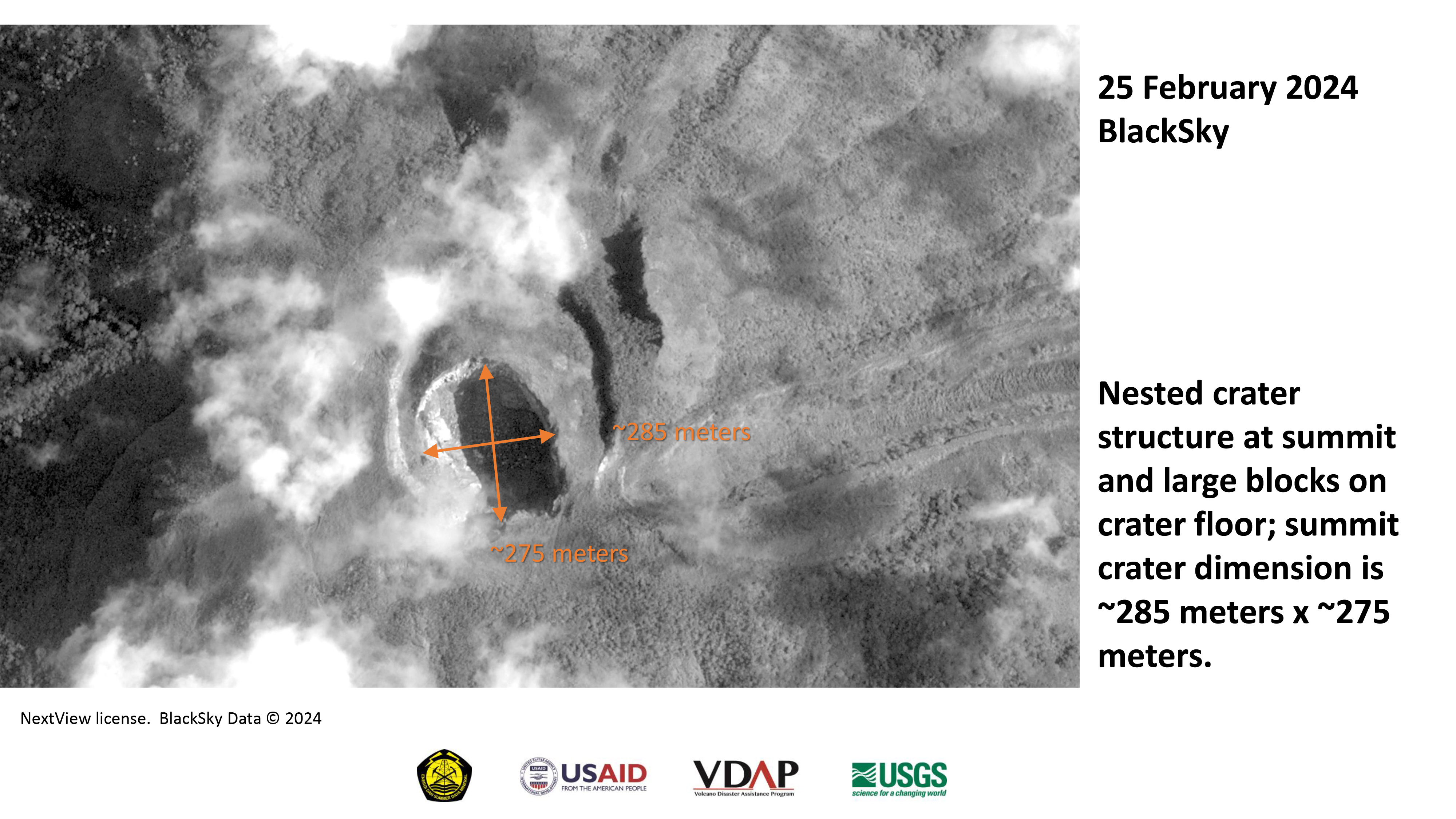
Dimensions of Gunung Ruang's crater prior to the eruption of 16-17 April 2024
Авторские права: BlackSky Technology Inc. (on behalf of itself and its Affiliates, collectively "BlackSky") provides notification that its imagery and logos are trademarked and under copyrights of BlackSky. The further use and/or dissemination of this imagery and/or any product in any way derived there from are restricted without express prior written permission.
Map produced by Ministry of Energy and Mineral Resources of Indonesia
Information about the Product
Получено: 25/02/2024
Источник: Global
Категория: Reference Map
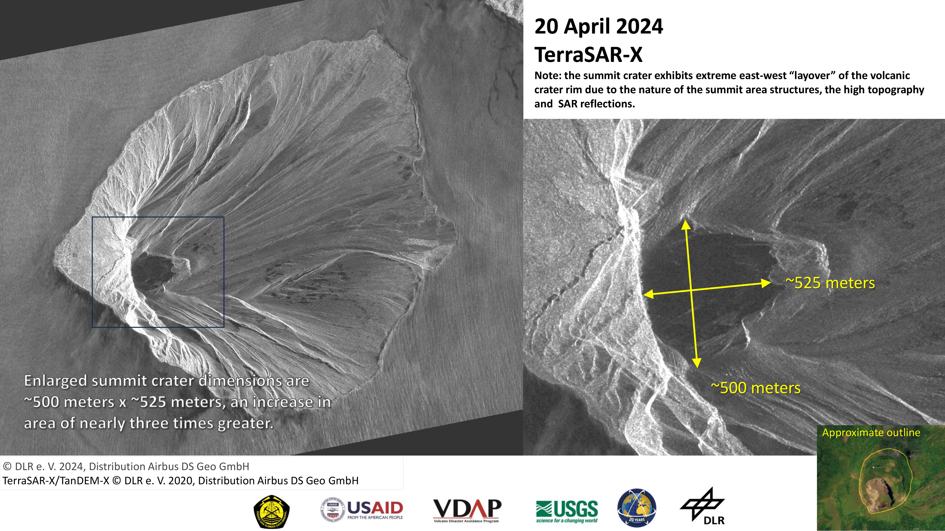
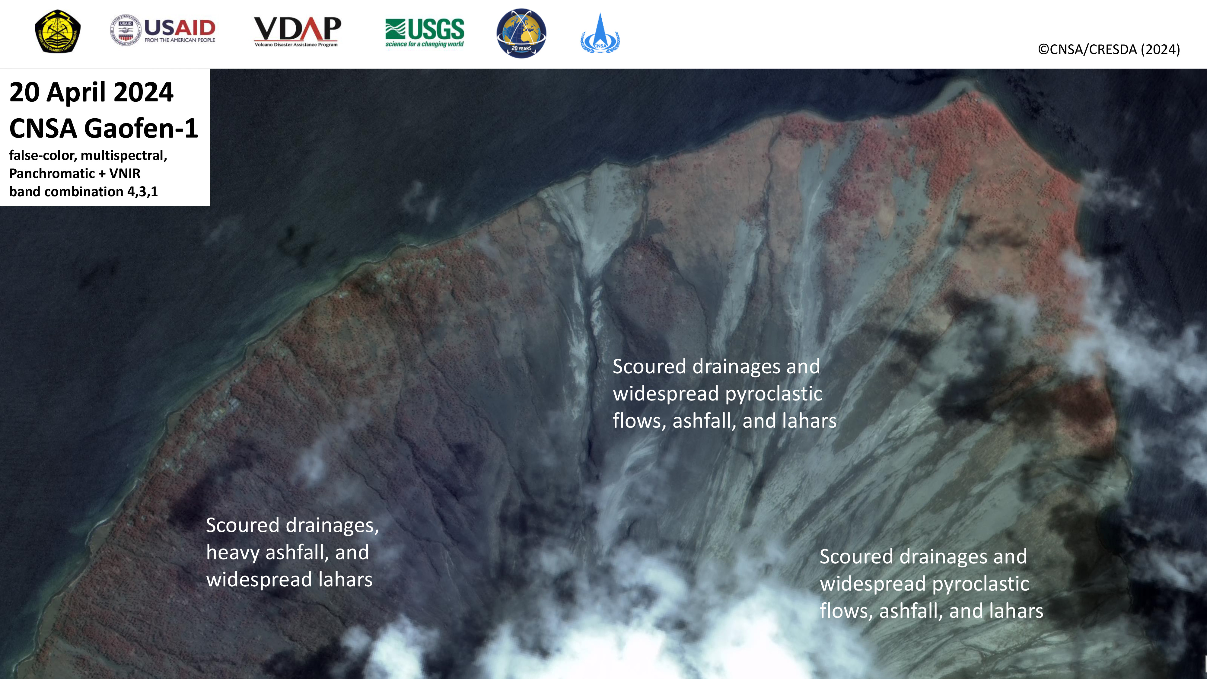
Preliminary assessment of volcanic impact to Gunung Ruang, Indonesia: summit crater enlargement
Авторские права: © DLR e.V. (2024), Distribution Airbus DS Geo GmbH
Map produced by Ministry of Energy and Mineral Resources of Indonesia
Information about the Product
Получено: 20/04/2024
Источник: TerraSAR-X
Категория: Delineation Map
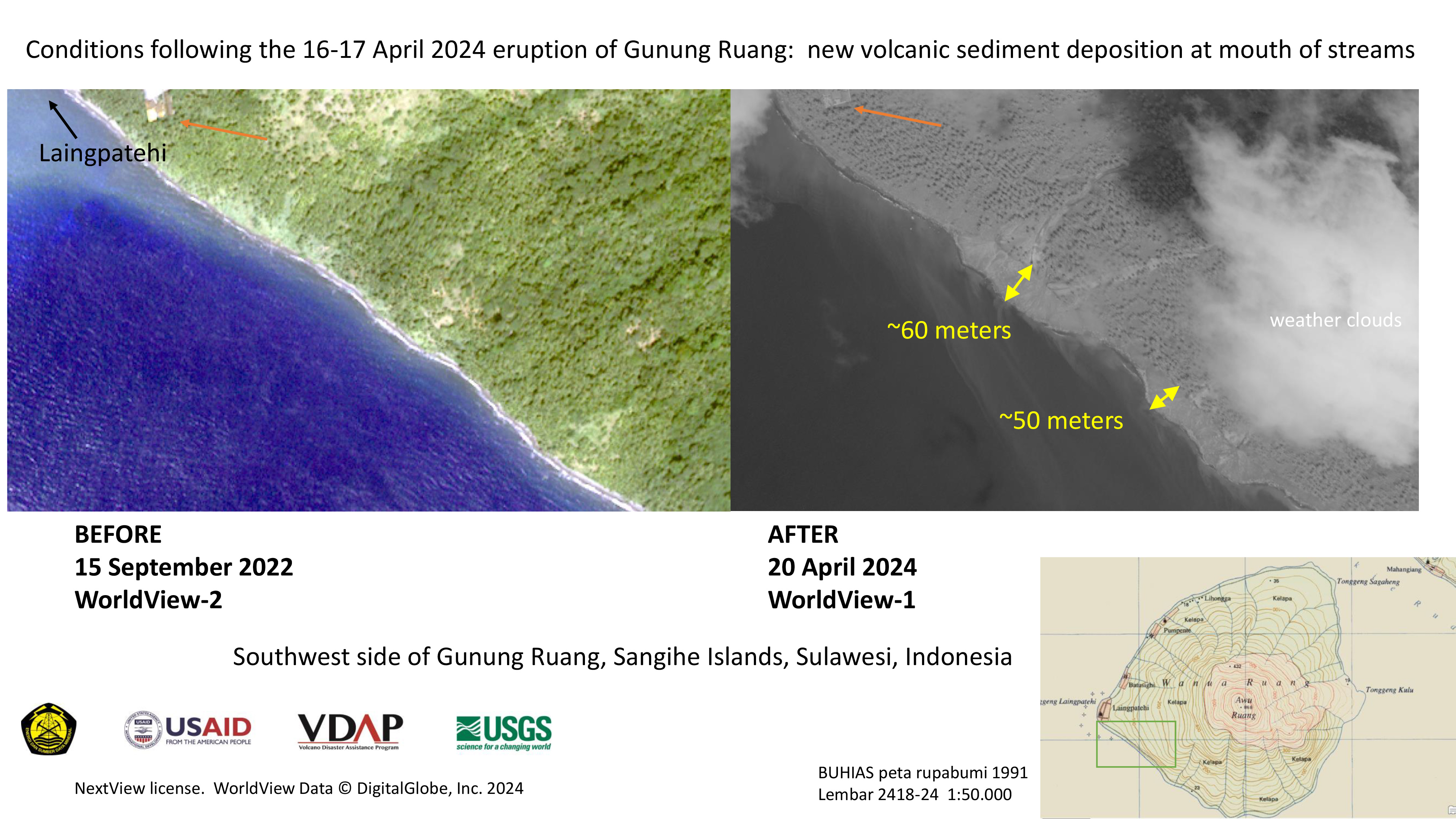
Preliminary assessment of volcanic impact to Gunung Ruang, Indonesia: southwest coast
Авторские права: © 2024 DigitalGlobe, Inc., Longmont CO USA 80503. DigitalGlobe and the DigitalGlobe logos are trademarks of DigitalGlobe, Inc. The use and/or dissemination of this data and/or of any product in any way derived there from are restricted. Unauthorized use and/or dissemination is prohibited
Map produced by Ministry of Energy and Mineral Resources of Indonesia
Information about the Product
Получено: WorldView-1: 20/04/2024
WorldView-2: 15/09/2022
Источник: WorldView-1 / WorldView-2
Категория: Delineation Map
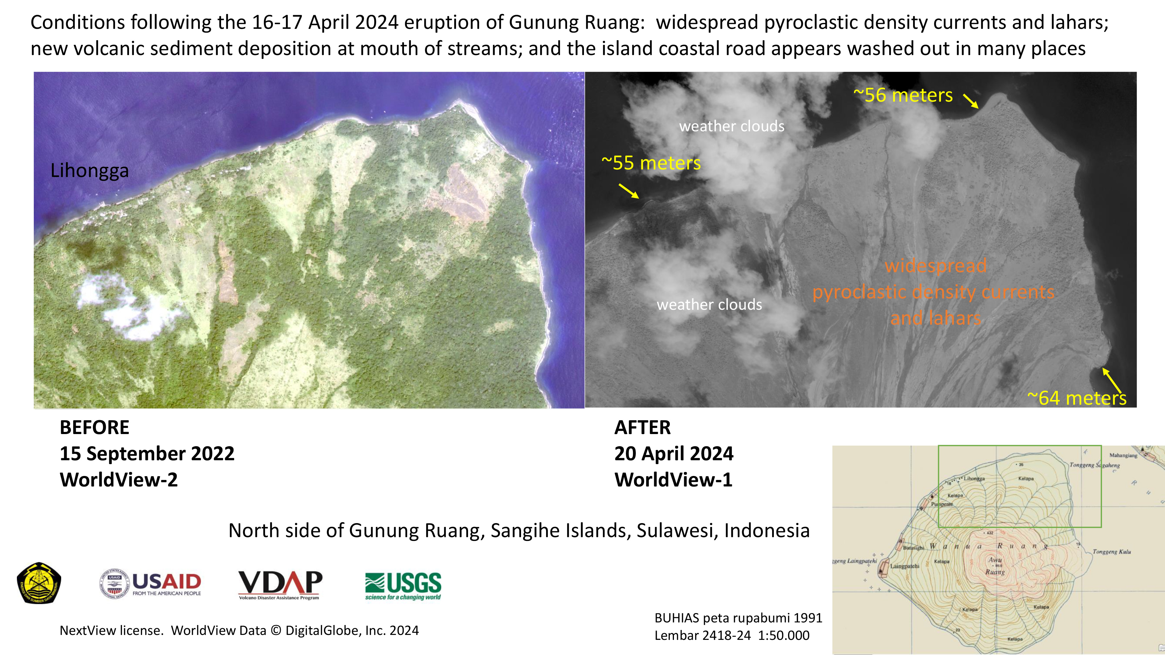
Preliminary assessment of volcanic impact to Gunung Ruang, Indonesia: north coast
Авторские права: © 2022 DigitalGlobe, Inc., Longmont CO USA 80503. DigitalGlobe and the DigitalGlobe logos are trademarks of DigitalGlobe, Inc. The use and/or dissemination of this data and/or of any product in any way derived there from are restricted. Unauthorized use and/or dissemination is prohibited
Map produced by Ministry of Energy and Mineral Resources of Indonesia
Information about the Product
Получено: WorldView-2: 15/09/2022
WorldView-1: 20/04/2024
Источник: WorldView-2 / WorldView-1
Категория: Delineation Map
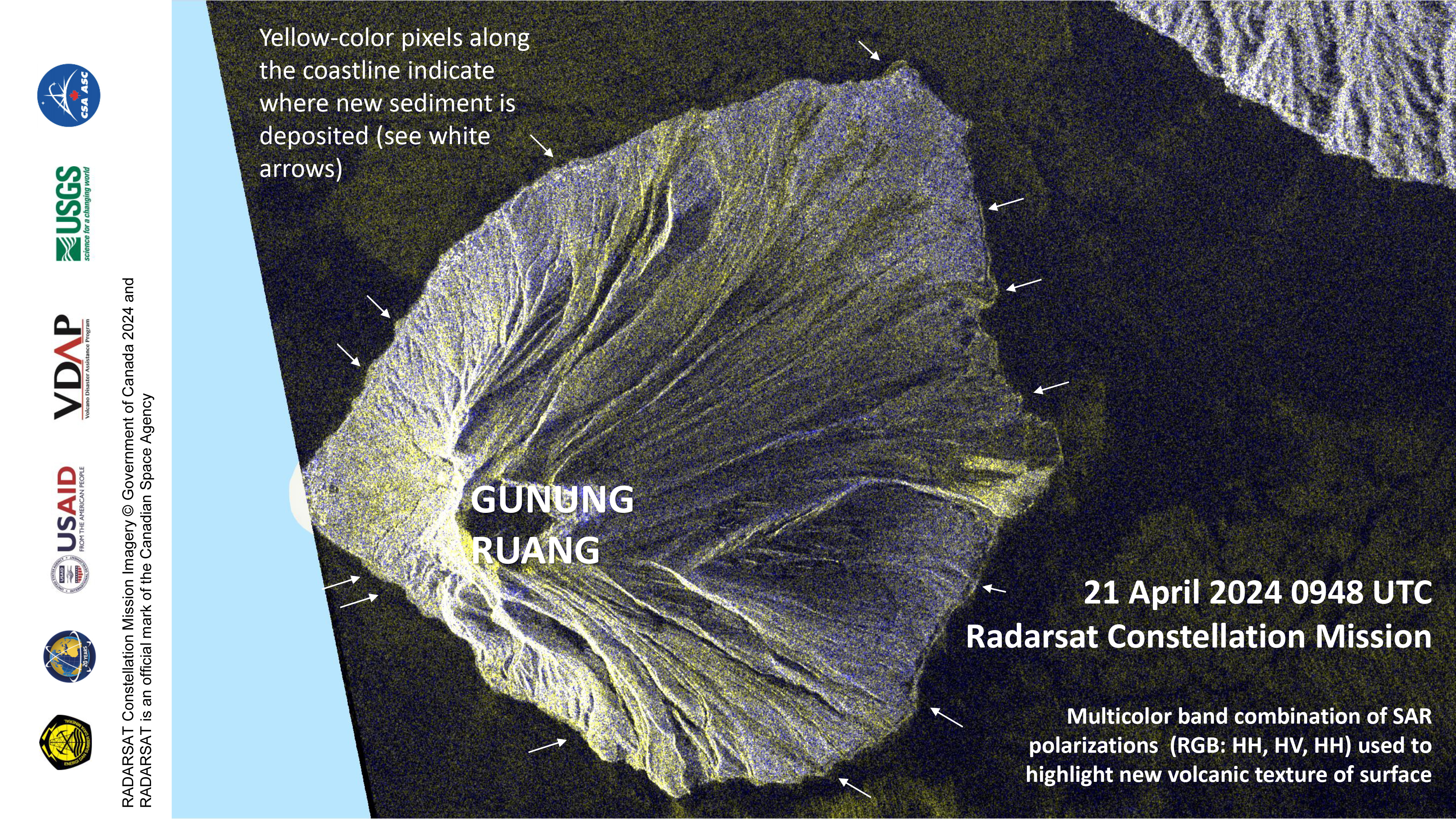
Preliminary map of pyroclastic flows on Gunung Ruang, Indonesia
Авторские права: RADARSAT Constellation Mission Imagery © Government of Canada (2024) - RADARSAT is an official mark of the Canadian Space Agency
Map produced by Ministry of Energy and Mineral Resources of Indonesia
Information about the Product
Получено: 21/04/2024
Источник: RCM
Категория: Delineation Map

Preliminary assessment of Gunung Ruang across the island following the 16-17 April 2024 eruption
Авторские права: RADARSAT Constellation Mission Imagery © Government of Canada (2024) - RADARSAT is an official mark of the Canadian Space Agency
Map produced by Ministry of Energy and Mineral Resources of Indonesia
Information about the Product
Получено: 21/04/2024
Источник: RCM
Категория: Delineation Map
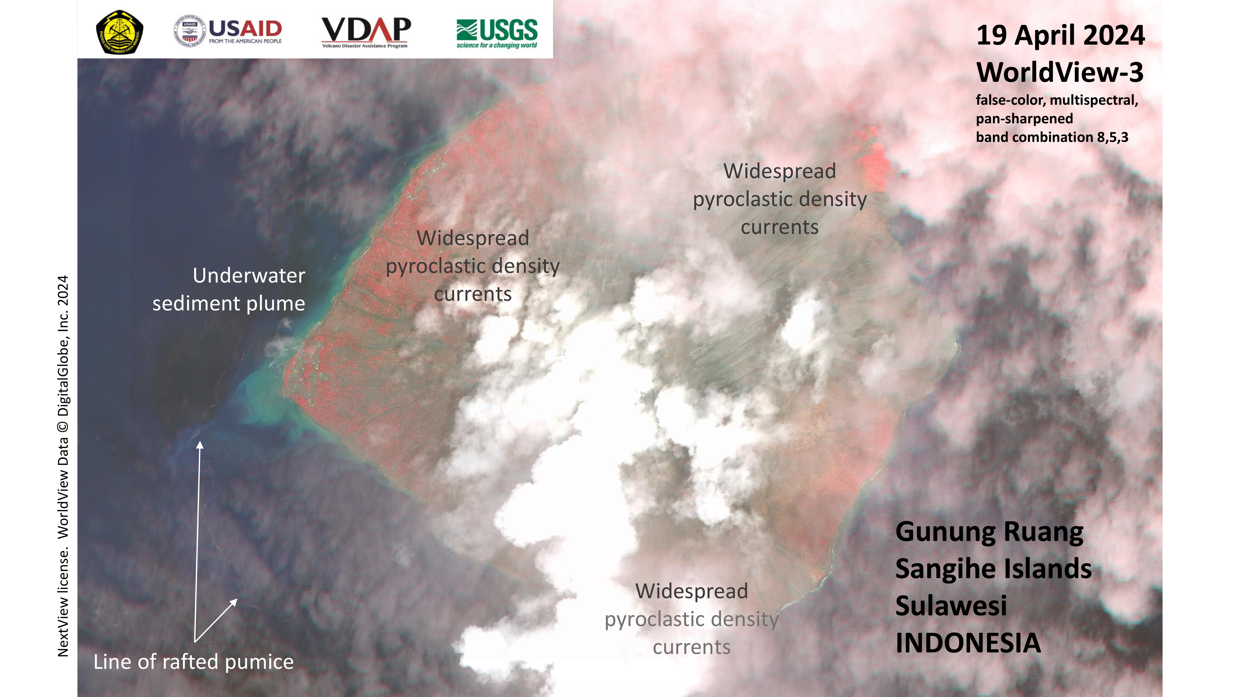
Preliminary assessment of volcanic impact to Gunung Ruang, Indonesia
Авторские права: © (2024) DigitalGlobe, Inc., Longmont CO USA 80503. DigitalGlobe and the DigitalGlobe logos are trademarks of DigitalGlobe, Inc. The use and/or dissemination of this data and/or of any product in any way derived there from are restricted. Unauthorized use and/or dissemination is prohibited
Map produced by Ministry of Energy and Mineral Resources of Indonesia
Information about the Product
Получено: 19/04/2024
Источник: WorldView-3
Категория: Delineation Map

Preliminary assessment of volcanic impact to Gunung Ruang, Indonesia: Laingpatehi
Авторские права: © 2024 DigitalGlobe, Inc., Longmont CO USA 80503. DigitalGlobe and the DigitalGlobe logos are trademarks of DigitalGlobe, Inc. The use and/or dissemination of this data and/or of any product in any way derived there from are restricted. Unauthorized use and/or dissemination is prohibited
Map produced by Ministry of Energy and Mineral Resources of Indonesia
Information about the Product
Получено: 19/04/2024
Источник: WorldView-3
Категория: Delineation Map

Preliminary assessment of volcanic impact to Gunung Ruang, Indonesia: north Laingpatehi
Авторские права: © 2024 DigitalGlobe, Inc., Longmont CO USA 80503. DigitalGlobe and the DigitalGlobe logos are trademarks of DigitalGlobe, Inc. The use and/or dissemination of this data and/or of any product in any way derived there from are restricted. Unauthorized use and/or dissemination is prohibited
Map produced Ministry of Energy and Mineral Resources of Indonesia
Information about the Product
Получено: 19/04/2024
Источник: WorldView-3
Категория: Delineation Map
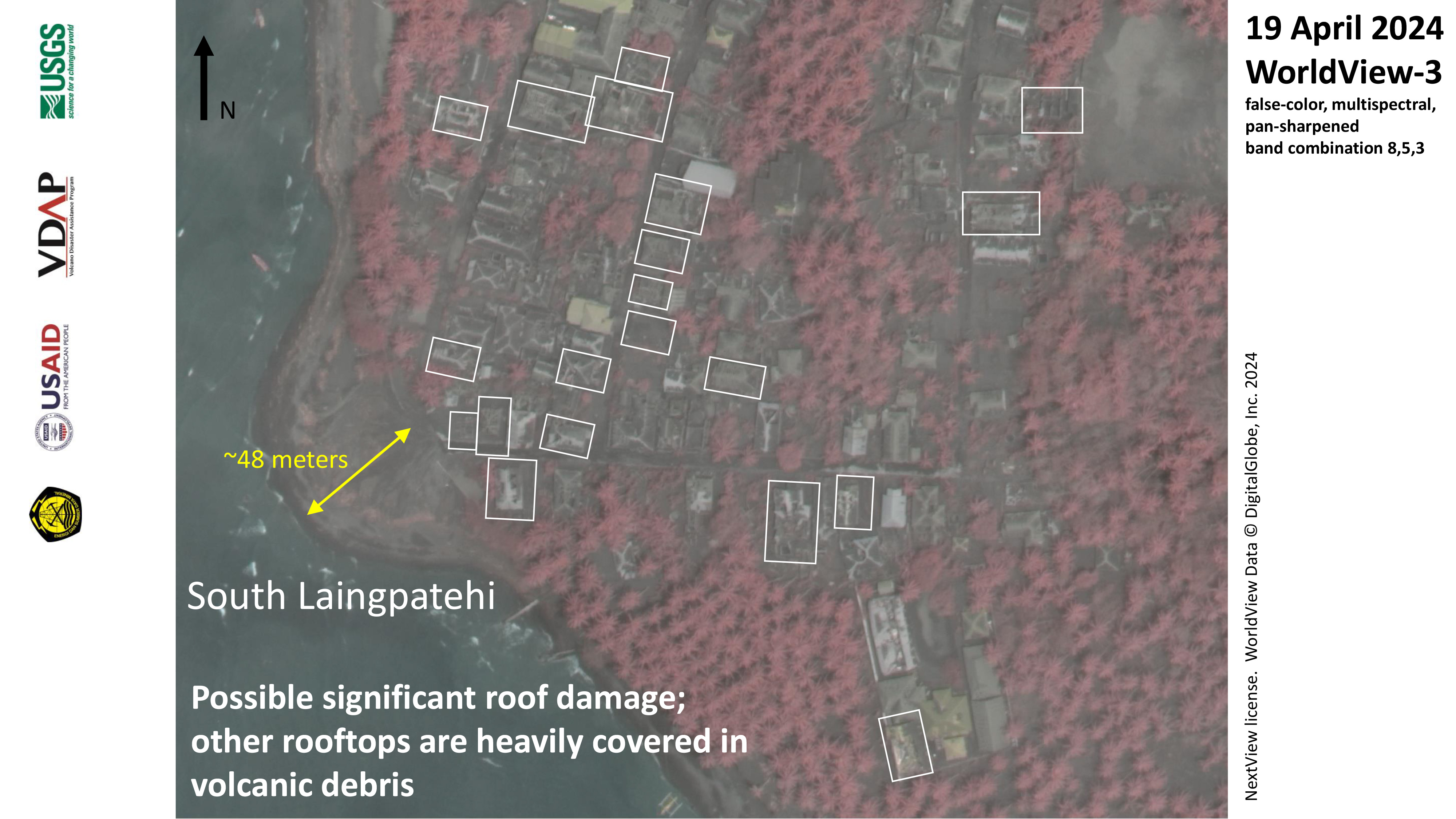
Preliminary assessment of volcanic impact to Gunung Ruang, Indonesia: south Laingpatehi
Авторские права: © 2024 DigitalGlobe, Inc., Longmont CO USA 80503. DigitalGlobe and the DigitalGlobe logos are trademarks of DigitalGlobe, Inc. The use and/or dissemination of this data and/or of any product in any way derived there from are restricted. Unauthorized use and/or dissemination is prohibited
Map produced by Ministry of Energy and Mineral Resources of Indonesia
Information about the Product
Получено: 19/04/2024
Источник: WorldView-3
Категория: Delineation Map
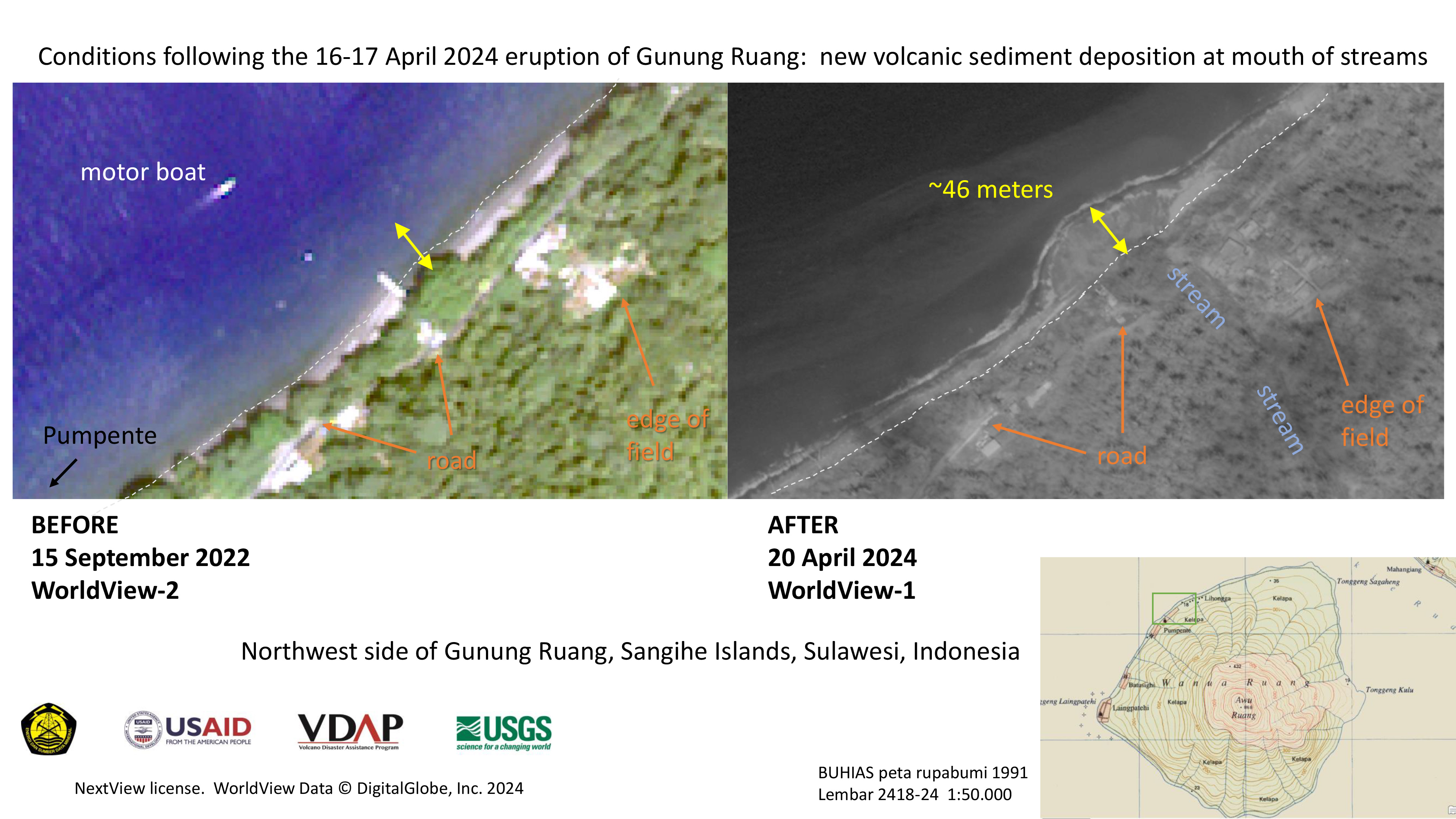
Preliminary assessment of volcanic impact to Gunung Ruang, Indonesia: near Pumpente on northwest shore
Авторские права: © 2022 DigitalGlobe, Inc., Longmont CO USA 80503. DigitalGlobe and the DigitalGlobe logos are trademarks of DigitalGlobe, Inc. The use and/or dissemination of this data and/or of any product in any way derived there from are restricted. Unauthorized use and/or dissemination is prohibited
Map produced by Ministry of Energy and Mineral Resources of Indonesia
Information about the Product
Получено: WorldView-2: 15/09/2022
WorldView-1: 20/04/2024
Источник: WorldView-2 / WorldView-1
Категория: Delineation Map

Preliminary assessment of volcanic impact to Gunung Ruang, Indonesia: northwest coast
Авторские права: © 2022 DigitalGlobe, Inc., Longmont CO USA 80503. DigitalGlobe and the DigitalGlobe logos are trademarks of DigitalGlobe, Inc. The use and/or dissemination of this data and/or of any product in any way derived there from are restricted. Unauthorized use and/or dissemination is prohibited
Map produced by Ministry of Energy and Mineral Resources of Indonesia
Information about the Product
Получено: WorldView-2: 22/09/2022
WorldView-1: 20/04/2024
Источник: WorldView-2 / WorldView-1
Категория: Delineation Map
 Вернуться к полному архиву активаций
