Свернуть Flooding in Argentina
« Назад

Flooding in Argentina

Charter activations

Flooding in Argentina

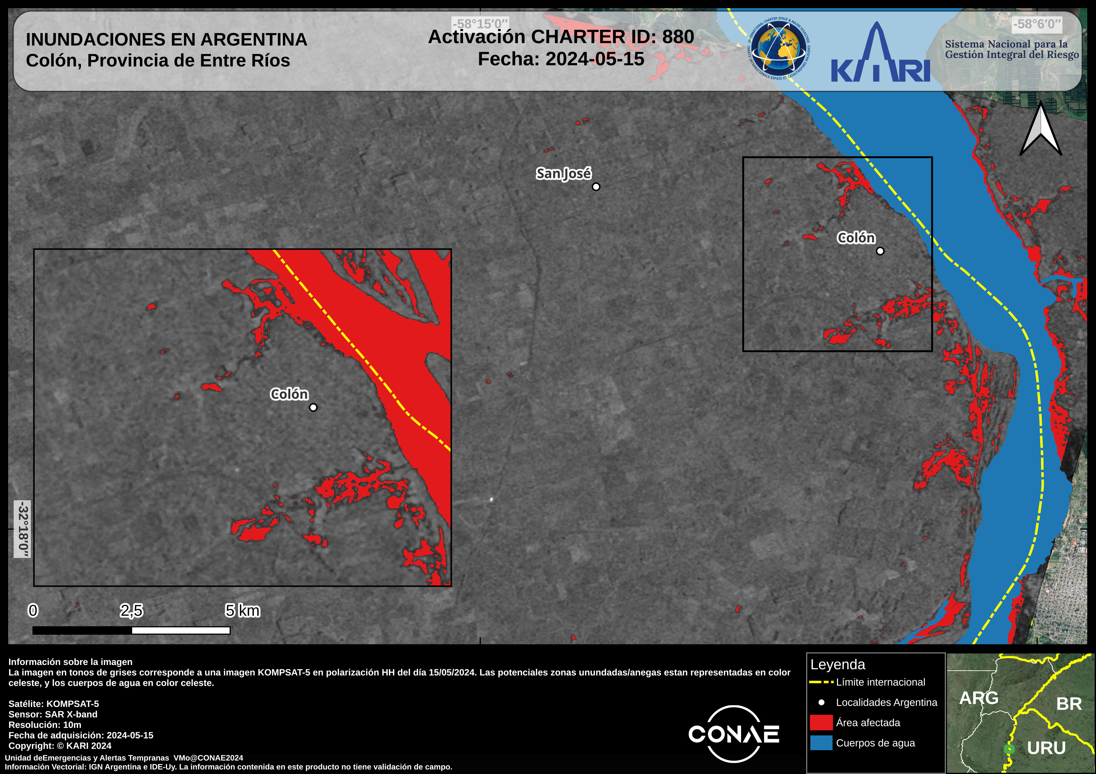
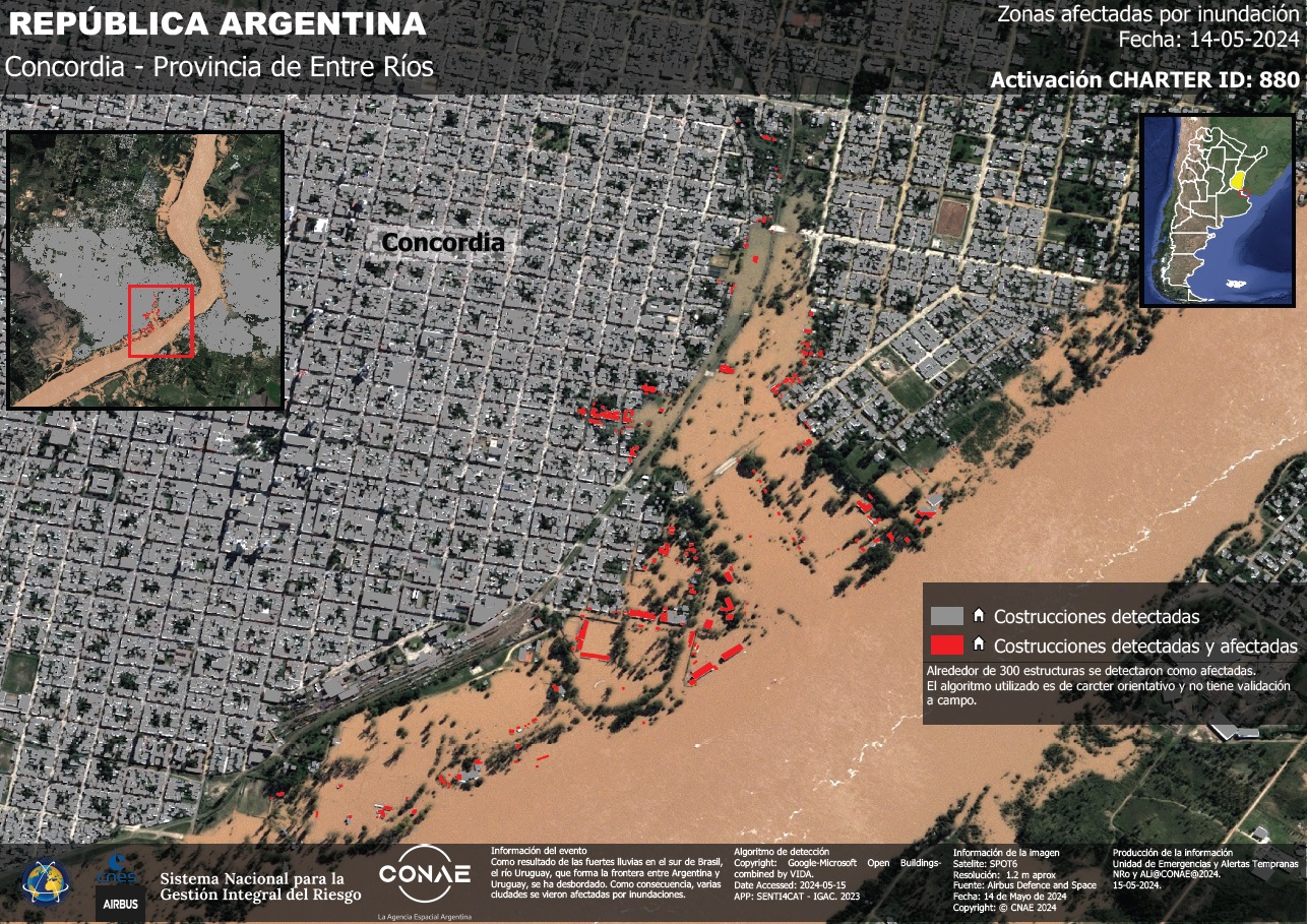
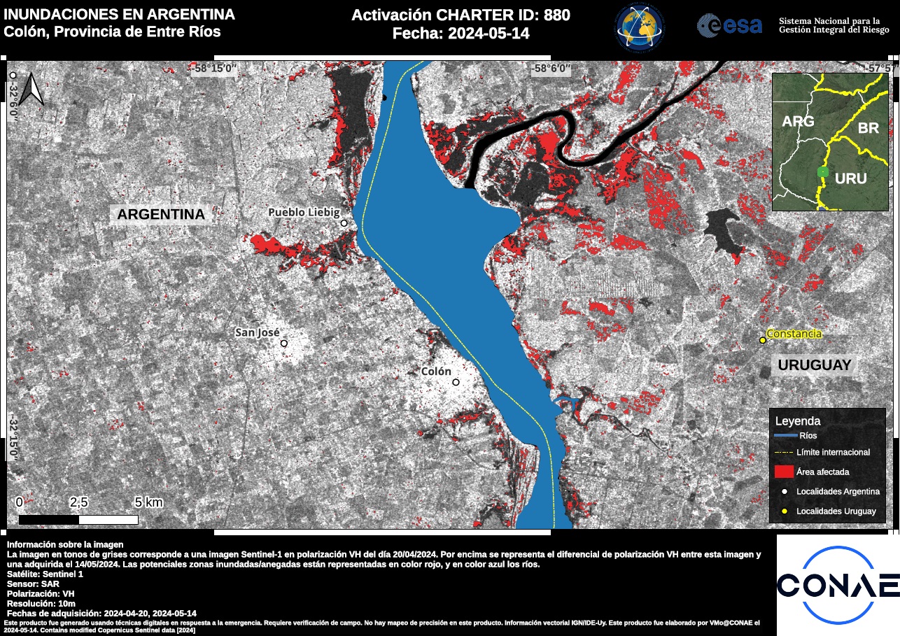
As a result of the heavy rains in southern Brazil, the Uruguay River, which forms the border between Argentina and Uruguay, has flooded. The city of Concordia, Entre Ríos, in Argentina, where the river runs through, has been particularly badly affected with approximately 500 people having to be evacuated.

Emergency response operations will continue until flood waters recede. Flooding is likely to impact other locations in close proximity to the Uruguay River and its tributaries. Disruptions to road travel and possibly power supply are possible.

Место события:Argentina
Date of Charter Activation:2024-05-13
Время активации Хартии:19:07
TЧасовой пояс в районе активации Хартии:UTC+02:00
Запрос на активацию поступил от:SIFEM – DNPC Argentina - SINAGIR
Номер активации:880
Менеждер проекта от:Andres Lighezzolo (CONAE)

Products

Areas affected by flooding of the Uruguay River in the city of Colón - Entre Ríos Province.

Авторские права: © CONAE (2024)
Map produce by CONAE

Information about the Product

Получено: 21/05/2024

Источник: SAOCOM

Категория: Delineation Map

Areas affected by flooding of the Uruguay River in the city of Concordia - Entre Ríos Province.

Авторские права: © CONAE (2024)
Map produced by CONAE

Information about the Product

Получено: 21/05/2024

Источник: SAOCOM

Категория: Delineation Map

Areas affected by flooding of the Uruguay River in the city of Concepción del Uruguay - Entre Ríos Province.

Авторские права: © CONAE (2024)
Map produced by CONAE

Information about the Product

Получено: 21/05/2024

Источник: SAOCOM

Категория: Delineation Map

Areas affected by flooding of the Uruguay River in the city of Concepción del Uruguay - Entre Ríos Province.

Авторские права: © CONAE (2024)
Map produced by CONAE

Information about the Product

Получено: 18/05/2024

Источник: Saocom

Категория: Delineation Map

Areas affected by flooding of the Uruguay River in the city of Colón - Entre Ríos Province.

Авторские права: © CONAE (2024)
Map produced by CONAE

Information about the Product

Получено: 18/05/2024

Источник: Saocom

Категория: Delineation Map

Areas affected by flooding of the Uruguay River in the city of Concordia - Entre Ríos Province.

Авторские права: Includes material © AIRBUS DS (2024)
Map produced by CONAE

Information about the Product

Получено: 18/05/2024

Источник: SPOT6

Категория: Delineation Map

Areas affected by flooding of the Uruguay River in the city of Concordia - Entre Ríos Province.

Авторские права: Includes material © AIRBUS DS (2024)
Map produced by CONAE

Information about the Product

Получено: 18/05/2024

Источник: SPOT6

Категория: Reference Map

Areas affected by flooding of the Uruguay River in the city of Colón - Entre Ríos Province.

Авторские права: Includes material © AIRBUS DS (2024)
Map produced by CONAE

Information about the Product

Получено: 18/05/2024

Источник: SPOT6

Категория: Delineation Monitoring Maps

Areas affected by flooding of the Uruguay River in the city of Concordia - Entre Ríos Province.

Авторские права: © KARI (2024).
Map produced by CONAE

Information about the Product

Получено: 15/05/2024

Источник: KOMPSAT-5

Категория: Delineation Map

Areas affected by flooding of the Uruguay River in the city of Concepción del Uruguay - Entre Ríos Province.

Авторские права: © KARI (2024).
Map produced by CONAE

Information about the Product

Получено: 15/05/2024

Источник: KOMPSAT-5

Категория: Delineation Map

Areas affected by flooding of the Uruguay River in the city of Colón - Entre Ríos Province.

Авторские права: © KARI (2024).
Map produced by CONAE

Information about the Product

Получено: 15/05/2024

Источник: KOMPSAT-5

Категория: Delineation Map

Areas affected by flooding of the Uruguay River in the city of Concordia - Entre Ríos Province

Авторские права: © Planet Labs Inc. (2024)
Map produced by CONAE

Information about the Product

Получено: 14/05/2024

Источник: PlanetScope

Категория: Delineation Monitoring Maps

Areas affected by flooding of the Uruguay River in the city of Concordia - Entre Ríos Province

Авторские права: © Planet Labs Inc. (2024)
Map produced by CONAE

Information about the Product

Получено: 03/05/2024, 14/05/2024

Источник: PlanetScope

Категория: Delineation Map

Areas affected by flooding of the Uruguay River in the city of Concepción del Uruguay - Entre Ríos Province.

Авторские права: © NTs OMZ, All Rights Reserved
Map produced by CONAE

Information about the Product

Получено: 15/05/2024

Источник: KANOPUS_V

Категория: Delineation Map

Areas affected by flooding of the Uruguay River in the city of Concordia - Entre Ríos Province.

Авторские права: © CONAE (2024)
Map produced by CONAE

Information about the Product

Получено: 15/05/2024

Источник: Saocom

Категория: Delineation Map

Areas affected by flooding of the Uruguay River in the city of Concepción del Uruguay - Entre Ríos Province.

Авторские права: © CONAE (2024)
Map produced by CONAE

Information about the Product

Получено: 15/05/2024

Источник: Saocom 1B

Категория: Delineation Map

Areas affected by flooding of the Uruguay River in the city of Colón in Entre Ríos Province, Argentina.

Авторские права: © CONAE (2024)
Map produced by CONAE

Information about the Product

Получено: 15/05/2024

Источник: SAOCOM

Категория: Delineation Map

Areas affected by flooding of the Uruguay River in the city of Concordia - Entre Ríos Province.

Авторские права: Includes material © AIRBUS DS (2024)
MAp produced by CONAE

Information about the Product

Получено: 14/05/2024

Источник: SPOT6

Категория: Delineation Map

Areas affected by flooding of the Uruguay River in the city of Gualeguaychú - Entre Ríos Province Argentina and Costa del Río - Uruguay

Авторские права: Contains modified Copernicus Sentinel data (2024)
Map produced by CONAE

Information about the Product

Получено: 14/05/2024

Источник: Sentinel-1

Категория: Grading Map

Areas affected by flooding of the Uruguay River in the city of Colón - Entre Ríos Province.

Авторские права: Contains modified Copernicus Sentinel data (2024)
Map produced by CONAE

Information about the Product

Получено: 14/05/2024

Источник: Sentinel-1

Категория: Grading Map

Areas affected by flooding of the Uruguay River in the city of Colón - Entre Ríos Province.

Авторские права: Contains modified Copernicus Sentinel data (2024)
Map produced by CONAE

Information about the Product

Получено: 14/05/2024

Источник: Sentinel-1

Категория: Delineation Map

Areas affected by flooding of the Uruguay River in the city of Concordia - Entre Ríos Province.

Авторские права: Contains modified Copernicus Sentinel data (2024)
Map produced by CONAE

Information about the Product

Получено: 14/05/2024

Источник: Sentinel-1

Категория: Grading Map

Areas affected by flooding of the Uruguay River in the city of Concordia - Entre Ríos Province.

Авторские права: Includes material © AIRBUS DS (2024)
Map produced by CONAE

Information about the Product

Получено: 14/05/2024

Источник: SPOT

Категория: Grading Map

Вернуться к полному архиву активаций