Свернуть Последняя Активация

Charter activations

Typhoon Molave in Vietnam

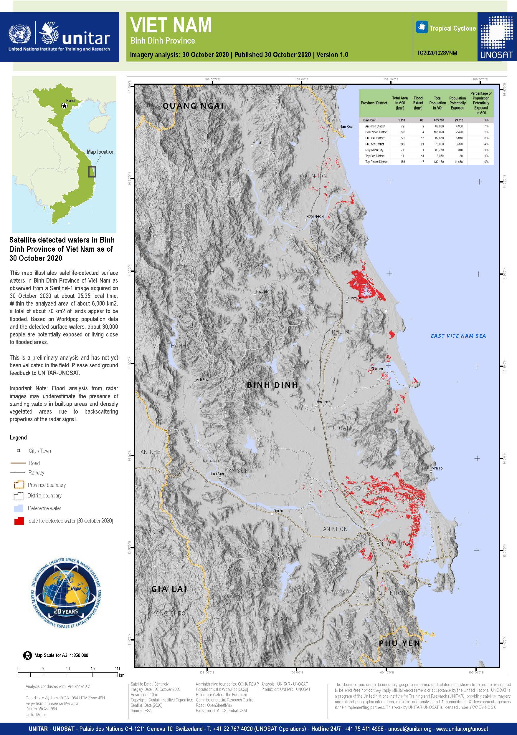
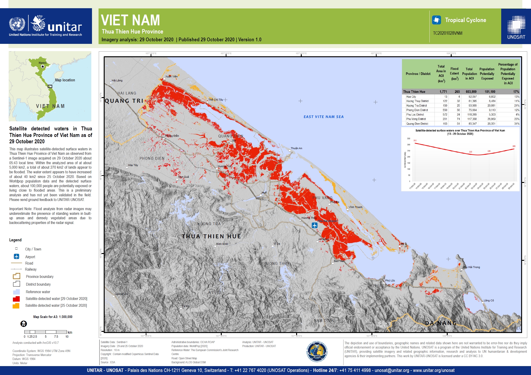
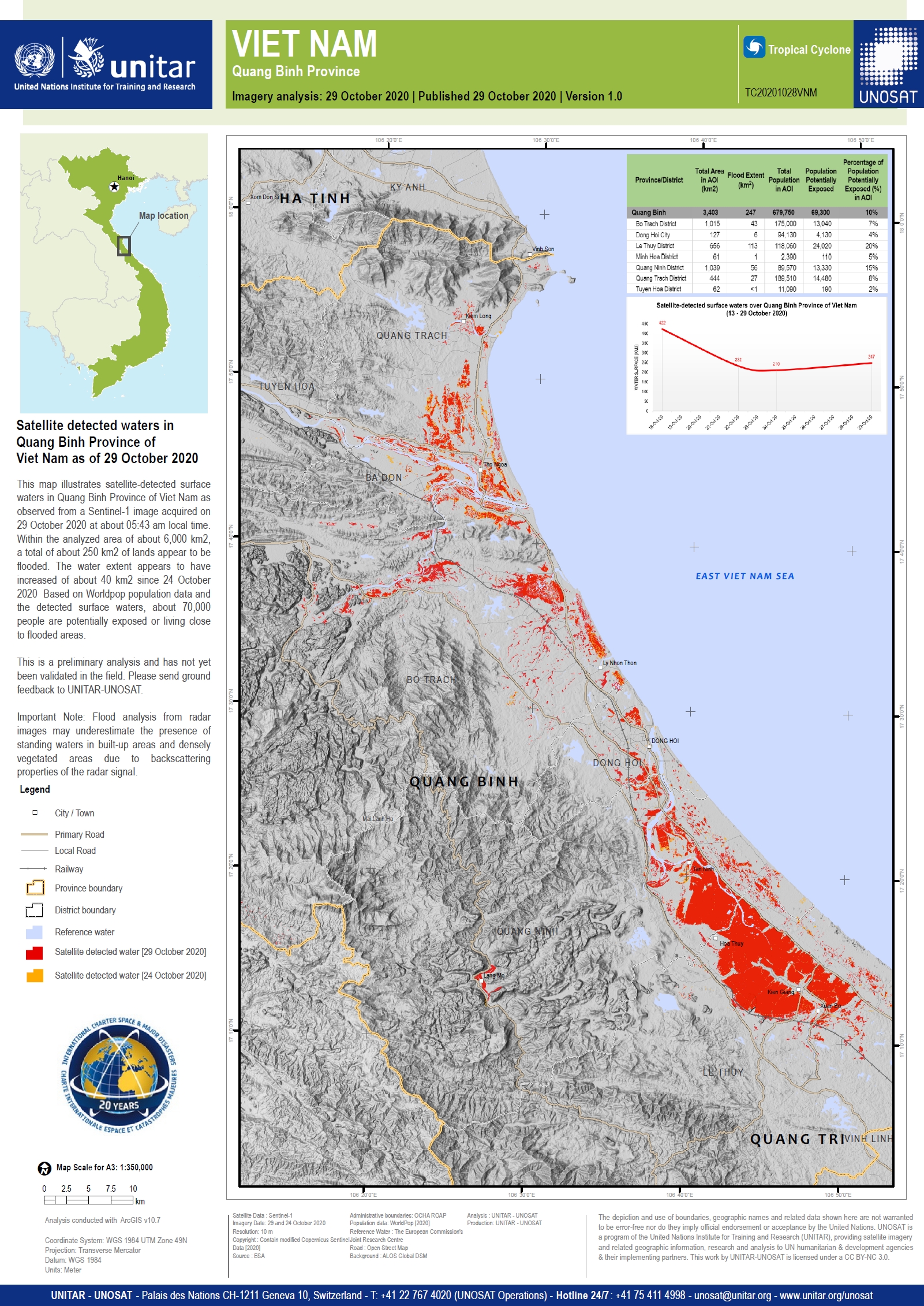
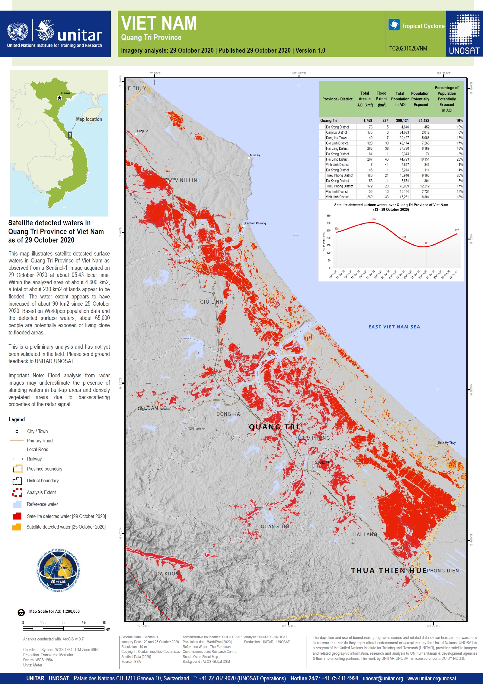
Typhoon Molave made landfall in central Quang Nam, Quang Ngai and Binh Dinh provinces with wind speeds of over 100 mph and heavy rainfall. Molave hit as a Category 2 Atlantic hurricane and is impacting areas of Vietnam already affected by severe flooding.

Vietmanese authorities are planning to evacuate over a million people and the military have been mobilised to provide search and rescue assistance.

Molave is the fourth storm system to make landfall in Vietnam in a month. The president of Vietnam's Red Cross reported recent events as the worst in decades. The damage brought by the storms has affected peoples livelihoods as many homes and crops have been destroyed, while the area is still suffering the impact of the Covid-19 pandemic.

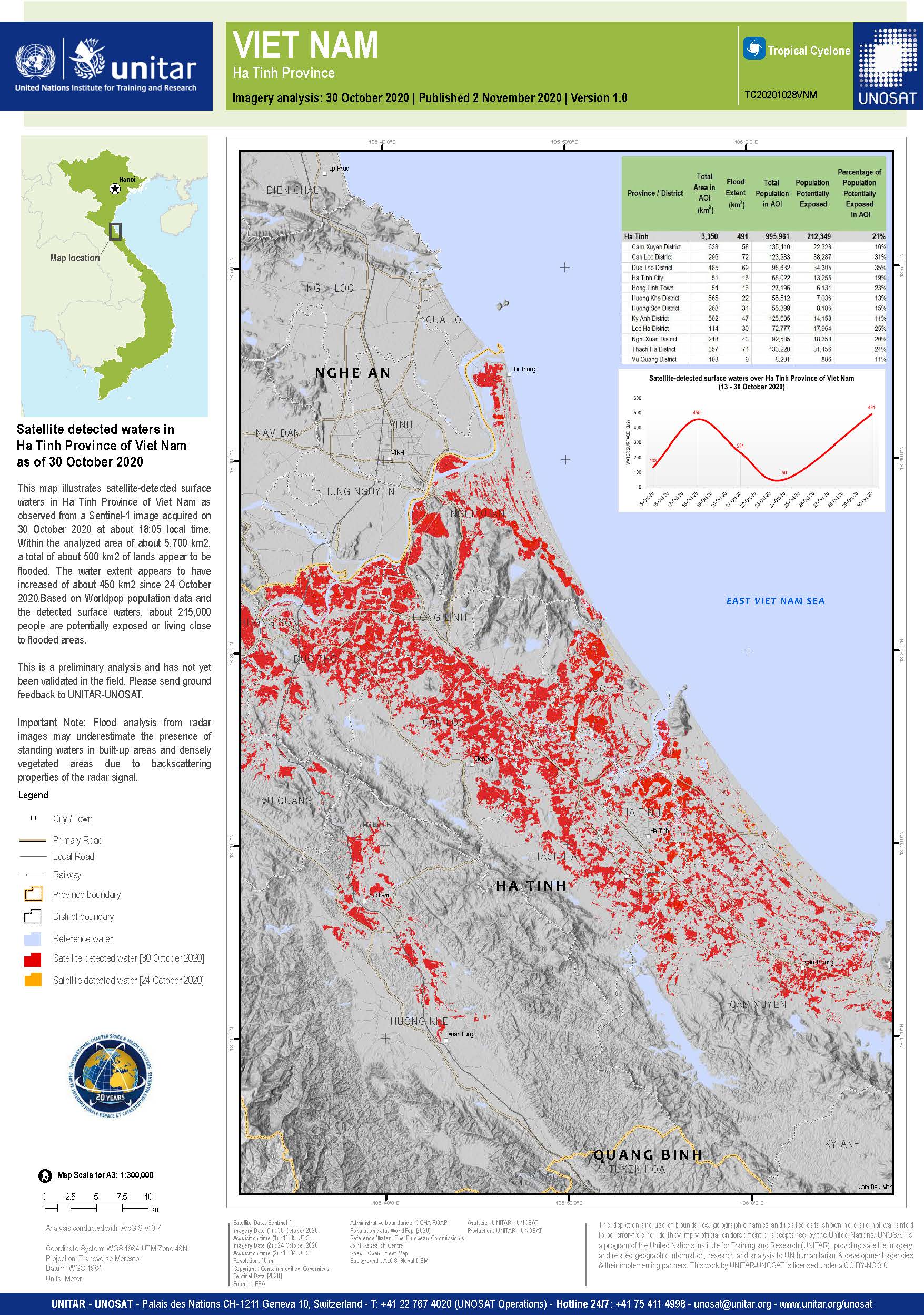
Nghe An, Ha Tinh and Quang Binh provinces have been told to prepare for prolonged downpours over the coming days, where over 700mm of rain is predicted.

Тип события:Cyclone
Место события:Vietnam
Date of Charter Activation:2020-10-28
Время активации Хартии:20:17
TЧасовой пояс в районе активации Хартии:UTC+07:00
Запрос на активацию поступил от:UNITAR on behalf of United Nations Office for the Coordination of Humanitarian Affairs (OCHA)
Номер активации:681
Менеждер проекта от:UNITAR/UNOSAT

Products

Satellite detected waters in Thua Thien Hue Province of Vietnam as of 10 November 2020

Авторские права: Contains modified Copernicus Sentinel data (2020)
Map produced by UNITAR / UNOSAT

Information about the Product

Получено: Sentinel-1: 09/11/2020

Источник: Sentinel-1

Satellite detected waters in Ha Tinh Province of Vietnam as of 9 November 2020

Авторские права: Contains modified Copernicus Sentinel data (2020)
Maps produced by UNITAR/UNOSAT

Information about the Product

Получено: 08/11/2020

Источник: Sentinel-1

Satellite detected waters in Nghe An Province of Vietnam as of 9 November 2020

Авторские права: Contains modified Copernicus Sentinel data (2020)
Maps produced by UNITAR/UNOSAT

Information about the Product

Получено: 08/11/2020

Источник: Sentinel-1

Satellite detected waters in Thua Thien Hue Province of Vietnam as of 4 November 2020

Авторские права: Contains modified Copernicus Sentinel data (2020)
Map produced by UNITAR / UNOSAT

Information about the Product

Получено: Sentinel -1: 03/11/2020

Источник: Sentinel -1

Satellite detected waters in Ha Tinh Province of Vietnam as of 3 November 2020

Авторские права: © CONAE (2020)
Map produced by UNITAR / UNOSAT

Information about the Product

Получено: Saocom 1: 03/11/2020

Источник: Saocom 1A

Satellite detected waters in Nghe An Province of Vietnam as of 31 October 2020

Авторские права: Contains modified Copernicus Sentinel data (2020)
Map produced by UNITAR / UNOSAT

Information about the Product

Получено: 30/10/2020

Источник: Sentinel-1

Satellite detected waters in Ha Tinh Province of Vietnam as of 30 October 2020

Авторские права: Contains modified Copernicus Sentinel data (2020)
Map produced by UNITAR / UNOSAT

Information about the Product

Получено: 30/10/2020

Источник: Sentinel-1

Preliminary satellite-derived flood assessment, Quang Binh, Quang Nam & Quang Ngai provinces, Vietnam

Download the full report

Авторские права: Includes Pleiades material © CNES (2020), Distribution Airbus DS.
Map produced by UNITAR / UNOSAT

Information about the Product

Получено: Pleiades: 01/11/2020 - 02/11/2020

Источник: Pleiades

Satellite detected waters in Quang Ngai Province of Vietnam as of 30 October 2020

Авторские права: Contains modified Copernicus Sentinel data (2020)
Map produced by UNITAR / UNOSAT

Information about the Product

Получено: Sentinel-1: 29/10/2020

Источник: Sentinel-1

Satellite detected waters in Da Nang City of Vietnam as of 30 October 2020

Авторские права: Contains modified Copernicus Sentinel data (2020)
Map produced by UNITAR / UNOSAT

Information about the Product

Получено: Sentinel-1: 29/10/2020

Источник: Sentinel-1

Satellite detected waters in Binh Dinh Province of Vietnam as of 30 October 2020

Авторские права: Contains modified Copernicus Sentinel data (2020)
Map produced by unitar - UNOSAT

Information about the Product

Получено: Sentinel-1: 29/10/2020

Источник: Sentinel-1

Satellite detected waters in Quang Nam Province of Vietnam as of 30 October 2020

Авторские права: Contains modified Copernicus Sentinel data (2020)
Map produced by unitar - UNOSAT

Information about the Product

Получено: Sentinel-1: 29/10/2020

Источник: Sentinel-1

Satellite detected waters in Thua Thien Hue Province of Vietnam as of 29 October 2020

Авторские права: Contains modified Copernicus Sentinel data (2020)
Map produced by UNITAR/UNOSAT

Information about the Product

Получено: 28/10/2020

Источник: Sentinel-1

Preliminary satellite-derived flood assessment, Quang Binh, Quang Tri, Quang Nam and Quang Ngai provinces, Vietnam

Download the full report

Авторские права: Includes Pleiades material © CNES (2020), Distribution Airbus DS.
Map produced by UNITAR/UNOSAT

Information about the Product

Получено: 29/10/2020

Источник: Pleiades

Satellite detected waters in Quang Binh Province of Vietnam as of 29 October 2020

Авторские права: Contains modified Copernicus Sentinel data (2020)
Map produced by UNITAR/UNOSAT

Information about the Product

Получено: 28/10/2020

Источник: Sentinel-1

Satellite detected waters in Quang Tri Province of Vietnam as of 29 October 2020

Авторские права: Contains modified Copernicus Sentinel data (2020)
Map produced by UNITAR/UNOSAT

Information about the Product

Получено: 28/10/2020

Источник: Sentinel-1

Вернуться к полному архиву активаций