 English
 Spanish
 French
 Chinese
 Russian
 Portuguese
 Последняя Активация
Charter activations
Flood in Morocco
Torrential downpours have hit North Africa's normally arid mountains and deserts causing flooding that has killed nearly two dozen people in Morocco and Algeria and destroyed homes and critical infrastructure.
In rural areas where infrastructure has historically been lacking, over 50 homes collapsed, several people were missing, drinking water and electrical infrastructure were damaged and damage to major roads, bridges and railway lines has also been reported
Large numbers of civil protection and military officers have been deployed to help with emergency response efforts and rescue families stuck in their homes.
In Morocco, officials said the two days of storms surpassed historic averages, in some cases exceeding the annual average rainfall. The downpours affected some of the regions that experienced a deadly earthquake one year ago.
| Тип события: | Flood |
| Место события: | Morocco |
| Date of Charter Activation: | 2024-09-13 |
| Время активации Хартии: | 19:55 |
| TЧасовой пояс в районе активации Хартии: | UTC+02:00 |
| Запрос на активацию поступил от: | UNOOSA/UN-SPIDER on behalf of Royal Centre for Spatial Teletection (CRTS) of the Kingdom of Morocco |
| Номер активации: | 913 |
| Менеждер проекта от: | Alexander Ariza (UNSPIDER) |
| act-value-adders: | Centre Royal de Télédétection Spatiale Hassan Arid (Centre Royal de Télédétection Spatiale) ESA PLES Meera AlShamsi (MBRSC) |
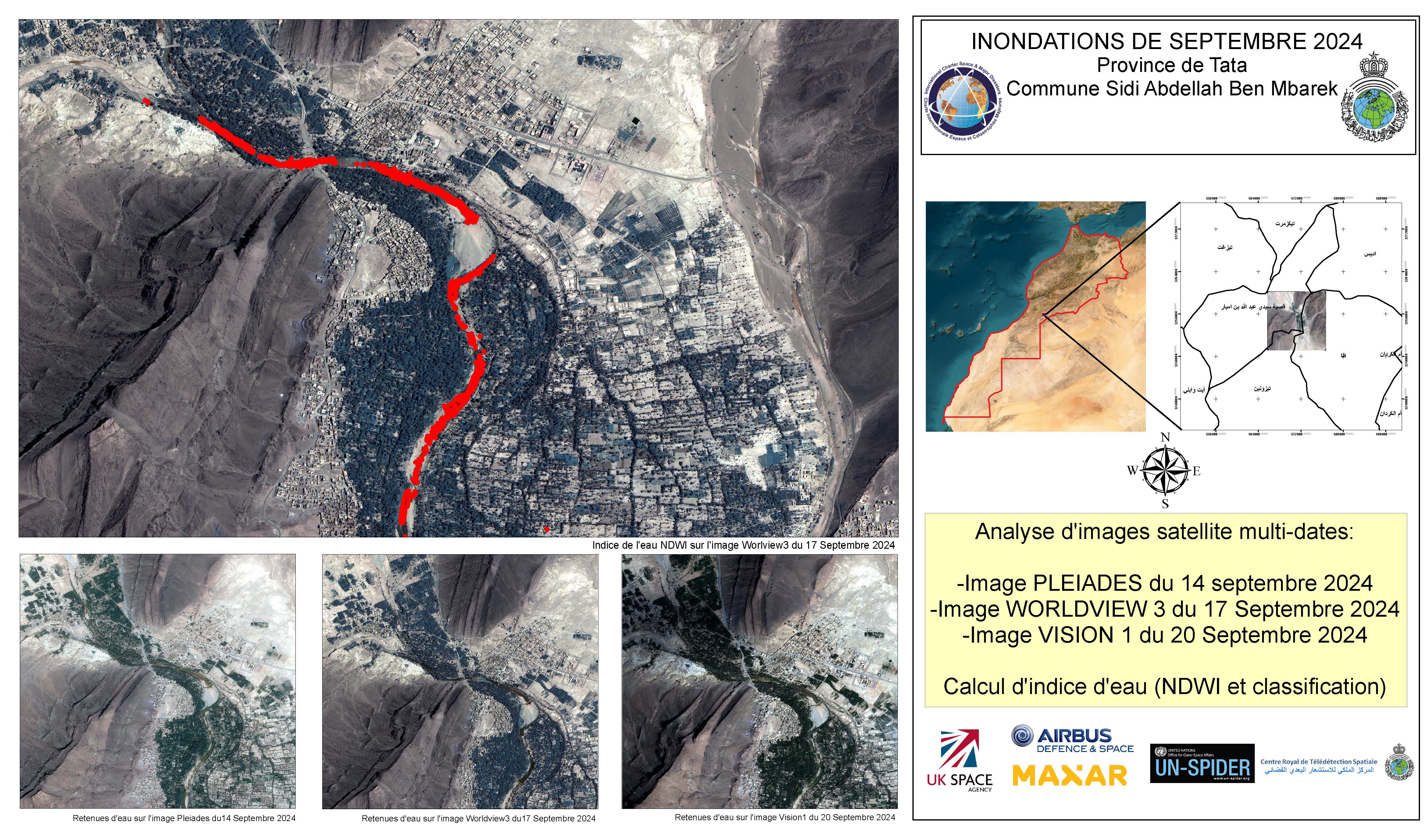
Products


Areas affected by flooding in the province of Zagora
Авторские права: Includes Pleiades material © CNES (2024), Distribution Airbus DS.
Contains modified Copernicus Sentinel data (2024)
Map produced by UN-SPIDER
Information about the Product
Получено: Pleiades: 14/09/2024
Sentinel-1: 12/09/2024
Источник: Pleiades, Sentinel-1
Категория: Delineation Map


Flooding in the the commune of Tamanrt and Douar Agrd in the Tata.
Авторские права: Includes Pleiades material © CNES (2024), Distribution Airbus DS.
© (2024) DigitalGlobe, Inc., Longmont CO USA 80503. DigitalGlobe and the DigitalGlobe logos are trademarks of DigitalGlobe, Inc. The use and/or dissemination of this data and/or of any product in any way derived there from are restricted. Unauthorized use and/or dissemination is prohibited
Map produced by UN-SPIDER
Information about the Product
Получено: WorldView-2: 01/09/2024, Pleiades: 14/09/2024
Источник: Pleiades / WorldView-2
Категория: Grading Map

Areas affected by flooding in the Province of Figuig - Talsint
Авторские права: Contains modified Copernicus Sentinel data (2024)
Includes Pleiades material © CNES (2024), Distribution Airbus DS.
Map produced by UN-SPIDER
Information about the Product
Получено: Sentinel-1: 11/09/202, Pleiades: 14/09/2024
Источник: Sentinel-1 / Pleiades
Категория: Delineation Map
 Вернуться к полному архиву активаций
