 English
 Spanish
 French
 Chinese
 Russian
 Portuguese
 Последняя Активация
Charter activations
Hurricane Matthew in Haiti
Hurricane Matthew, one of the most powerful Atlantic hurricanes in recent years, is causing havoc as it tears through the Caribbean. It has claimed over 170 lives in Haiti and affected tens of thousands of people.
Matthew, a Category Four storm, made landfall near Les Anglais on Haiti's west coast on 4 October. It brought winds in excess of 230km/h (145 mph) and heavy rain which has caused flooding. Tens of thousands of homes were destroyed, and some villages and towns were entirely destroyed. Thousands of people have been left homeless and while many survivors are being provided with tents and relief centres are being established, there are reports of hundreds of people seeking shelter in nearby caves while they wait for aid to arrive. It is estimated that more than a million people are affected.
Southern Haiti has also been left isolated after the La Digue Bridge - which connects the region to the capital city of Port-au-Prince - collapsed in the storm. The port of Les Cayes in the nation's southern region has reportedly suffered "catastrophic" damage and the entire town of 70,000 people has been inundated. With the primary access route severed, it is not known when the people affected in the southern region may receive aid from elsewhere in the country.
Famine poses an additional concern in the wake of the disaster. Many crops were destroyed by Hurricane Matthew, and the interim president of Haiti has stated that the county could be facing a famine in the next few months unless the situation changes.
Cases of cholera have risen since the storm, with more than 200 reported since Matthew hit the island. Doctors fear that there may be an epidemic without adequate supplies of vaccines and clean water.
The disaster has been described as the worst that Haiti has suffered since the devastating earthquake in 2010, from which the island nation was still recovering.
Hurricane Matthew has affected 16 countries in the Caribbean. While Haiti has suffered the worst of the damage, it also impacted the neighbouring Dominican Republic and moved north to affect Cuba, the Bahamas and the United States.
| Тип события: | Ocean Storm - Hurricane |
| Место события: | Haiti |
| Date of Charter Activation: | 03 October 2016 |
| Время активации Хартии: | 22:00:00 |
| TЧасовой пояс в районе активации Хартии: | UTC+02:00 |
| Запрос на активацию поступил от: | -USGS on behalf of Pacific Disaster Center -COGIC -UNITAR-UNOSAT on behalf of UNOCHA |
| Менеждер проекта от: | Pacific Disaster Center |
Products
Preliminary damage assessment report of Grand Anse, South and Nippes in Haiti
Download the full report
Авторские права: Report produced by UNITAR/UNOSAT
Information about the Product
Получено: Pre-disaster: 08/12/2014, 28/11/2014, 01/05/2015, 09/05/2015, 14/06/2015, 16/06/2015, 17/10/2015, 17/07/2016
Post-disaster: 07/10/2016, 09/10/2016, 12/10/2016, 17/10/2016, 09/11/2016
Источник: Pleiades / WorldView-1, -2 and -3
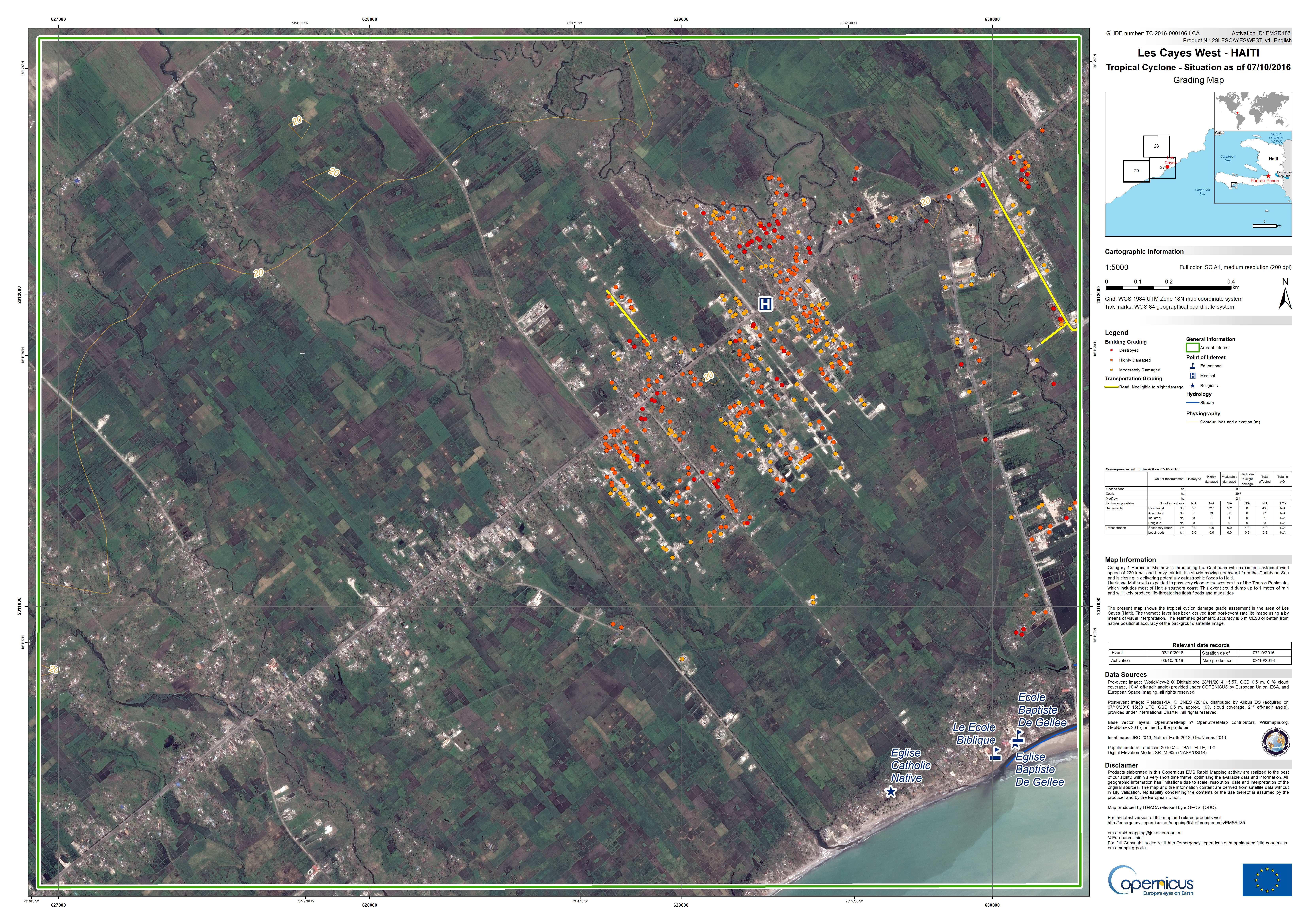
Situation in Les Cayes West, Haiti on 07/10/2016
Авторские права: WorldView-2 © DigitalGlobe 2016
Pleiades © CNES 2016 - Distribution: Airbus Defence and Space, all rights reserved
Map produced by ITHACA
Information about the Product
Получено: Pre-disaster: 28/11/2014
Post-disaster: 07/10/2016
Источник: WorldView-2 / Pleiades
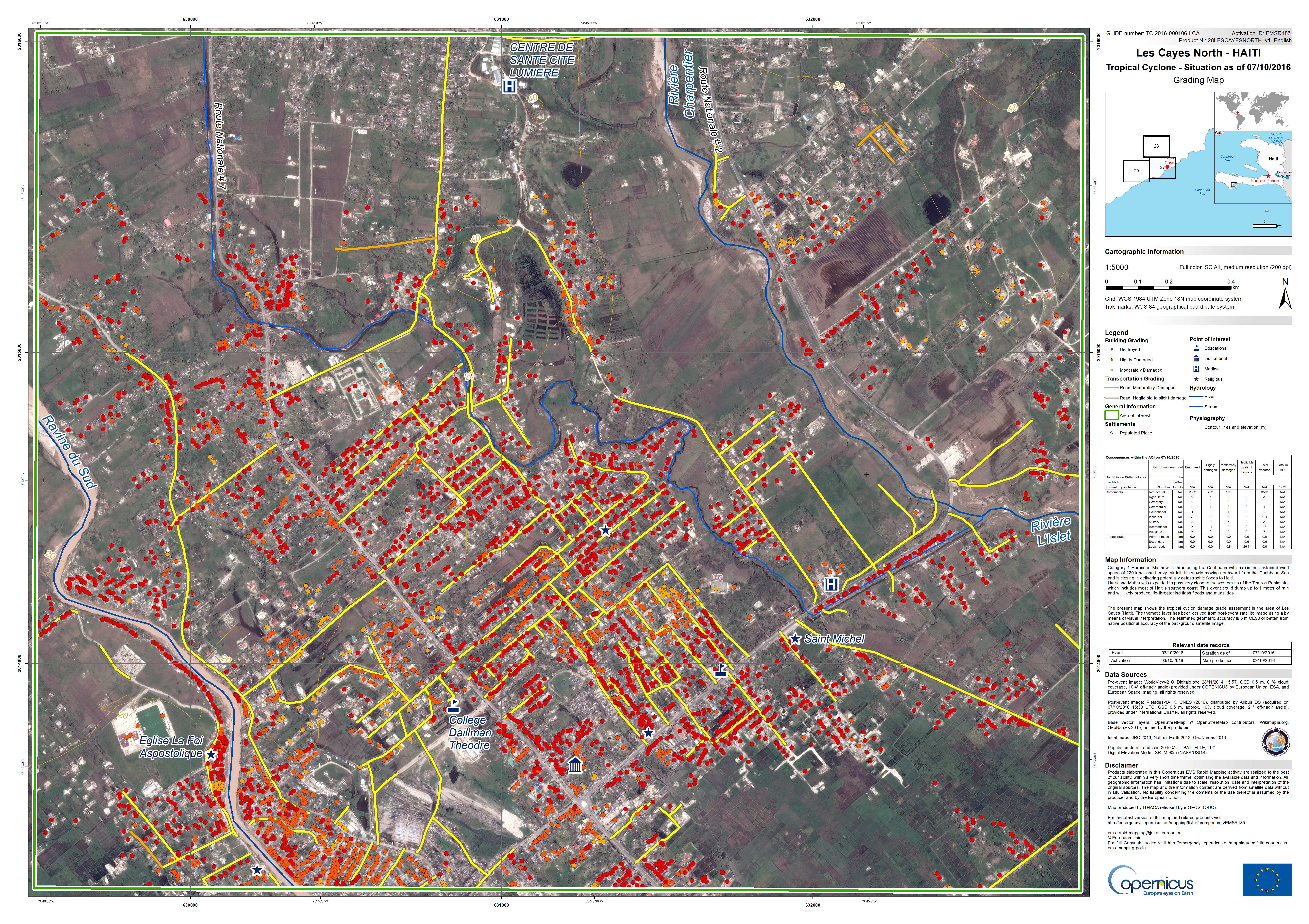
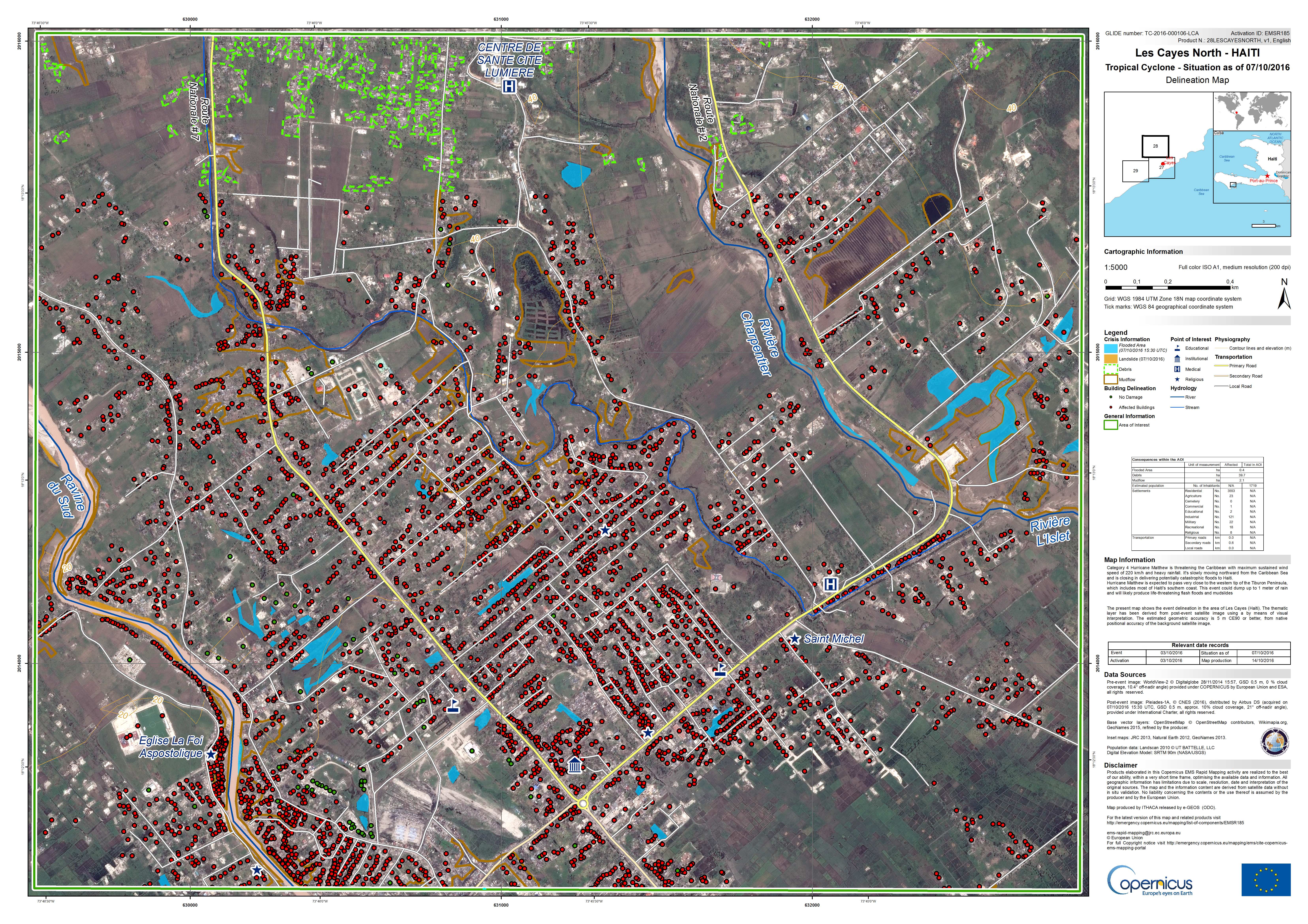
Situation in Les Cayes North, Haiti on 07/10/2016
Авторские права: WorldView-2 © DigitalGlobe 2016
Pleiades © CNES 2016 - Distribution: Airbus Defence and Space, all rights reserved
Map produced by ITHACA
Information about the Product
Получено: Pre-disaster: 28/11/2014
Post-disaster: 07/10/2016
Источник: WorldView-2 / Pleiades
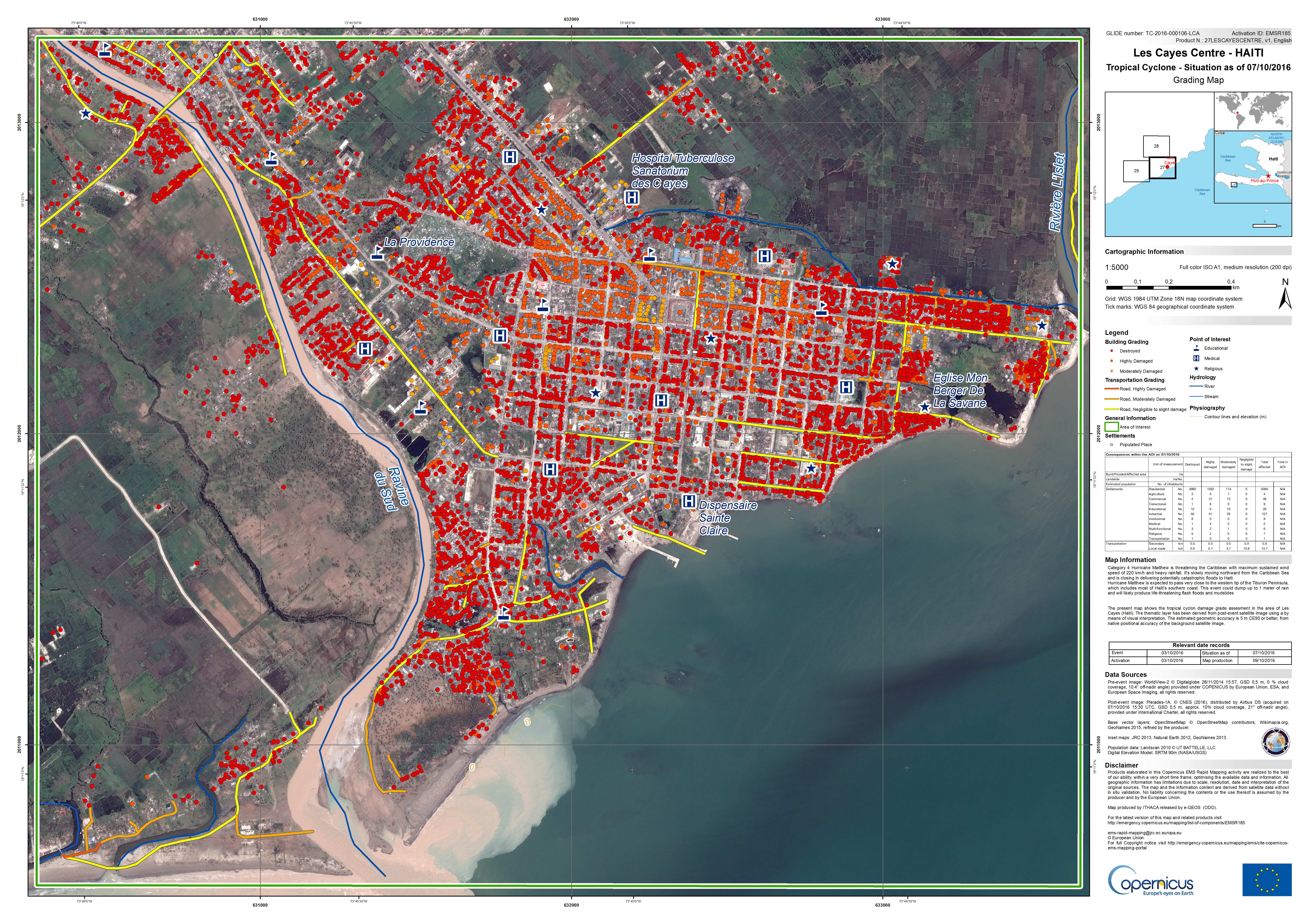
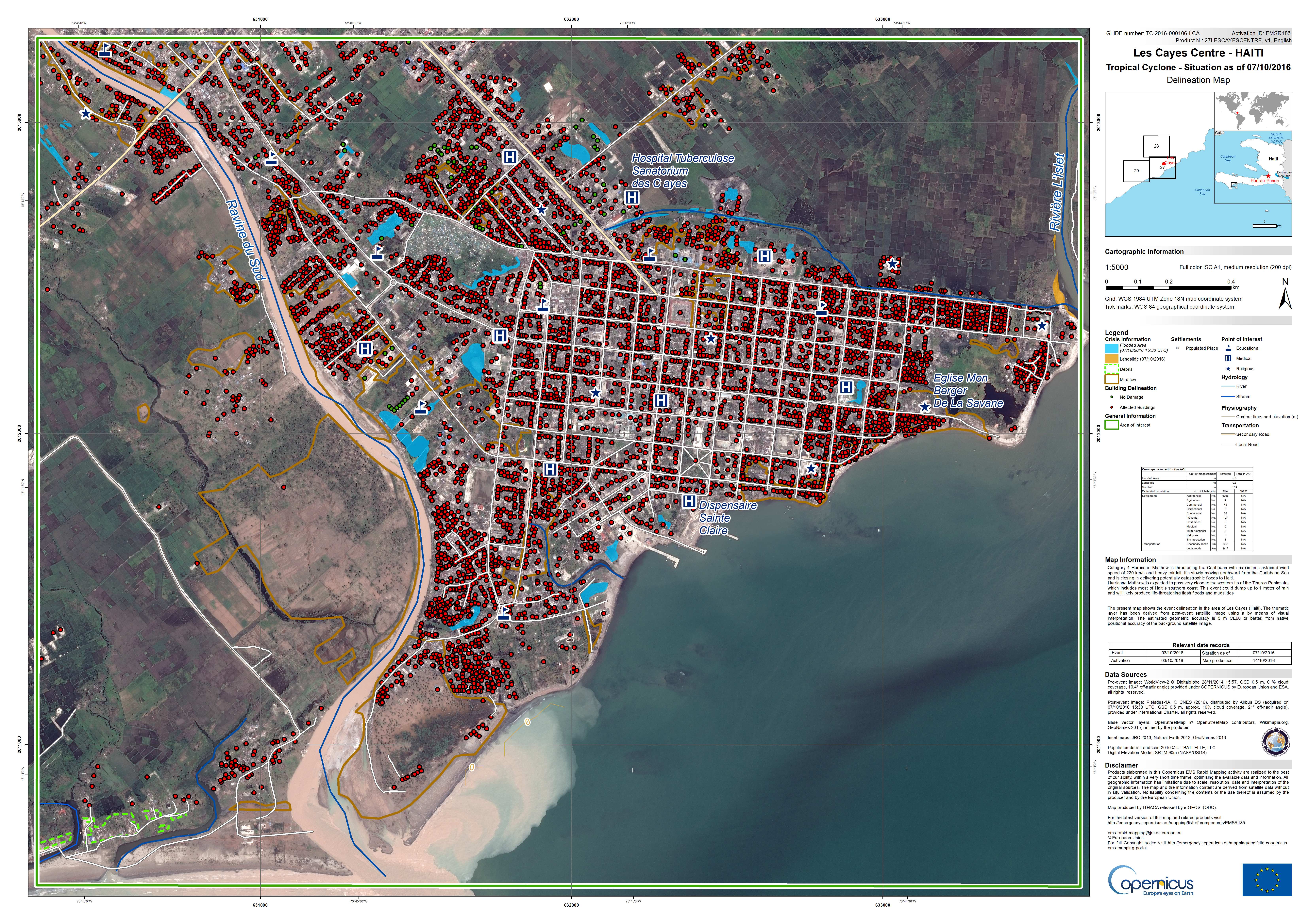
Situation in Les Cayes Centre, Haiti on 07/10/2016
Авторские права: WorldView-2 © DigitalGlobe 2016
Pleiades © CNES 2016 - Distribution: Airbus Defence and Space, all rights reserved
Map produced by ITHACA
Information about the Product
Получено: Pre-disaster: 28/11/2014
Post-disaster: 07/10/2016
Источник: WorldView-2 / Pleiades
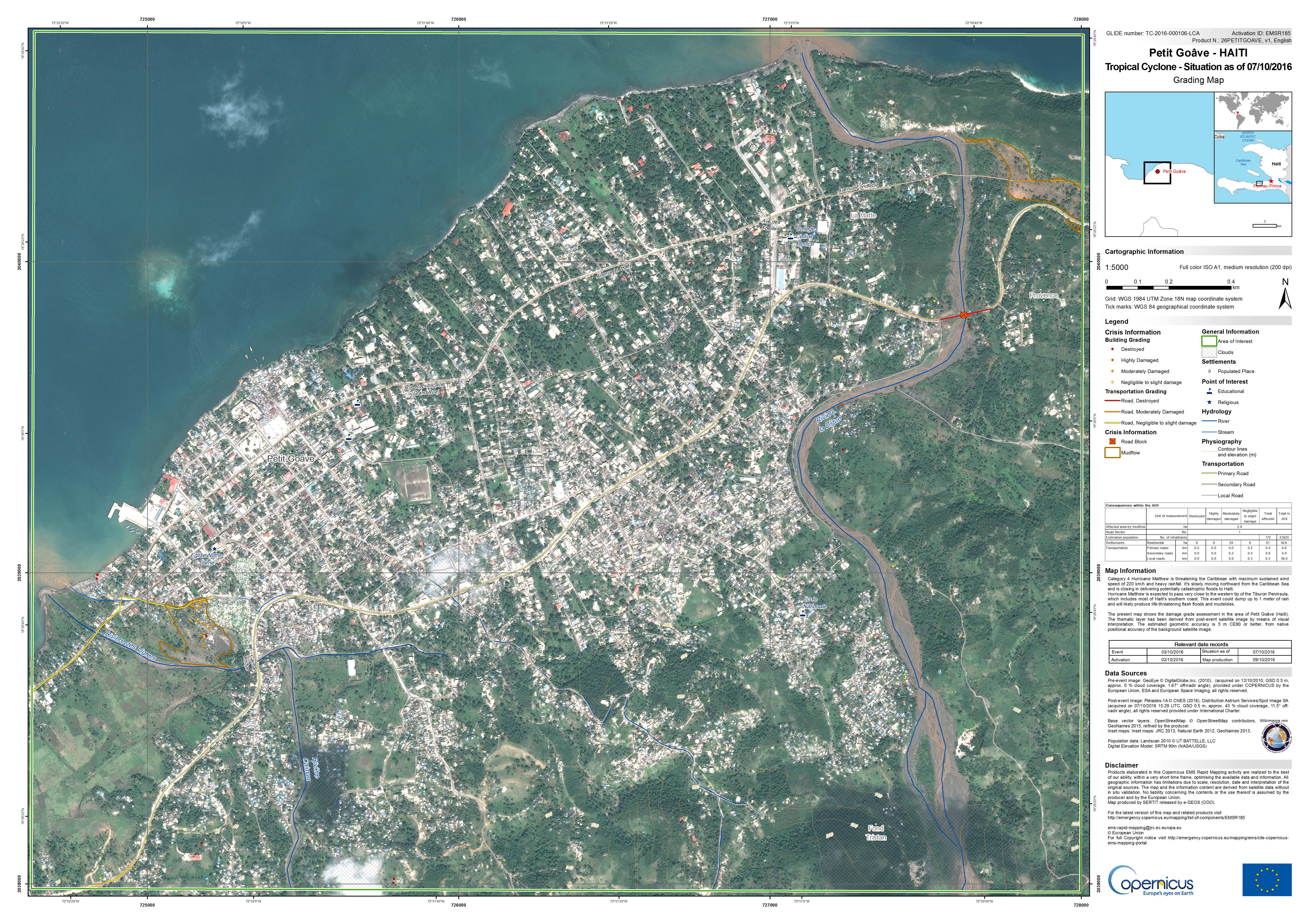
Situation in Petit Goave, Haiti on 07/10/2016
Авторские права: GeoEye © DigitalGlobe 2016
Pleiades © CNES 2016 - Distribution: Airbus Defence and Space, all rights reserved
Map produced by SERTIT
Information about the Product
Получено: Pre-disaster: 12/10/2010
Post-disaster: 07/10/2016
Источник: GeoEye / Pleiades

Situation in Grand Goave, Haiti on 07/10/2016
Авторские права: WorldView-2 © DigitalGlobe 2016
Pleiades © CNES 2016 - Distribution: Airbus Defence and Space, all rights reserved
Map produced by SERTIT
Information about the Product
Получено: Pre-disaster: 12/10/2010
Post-disaster: 07/10/2016
Источник: WorldView-2 / Pleiades
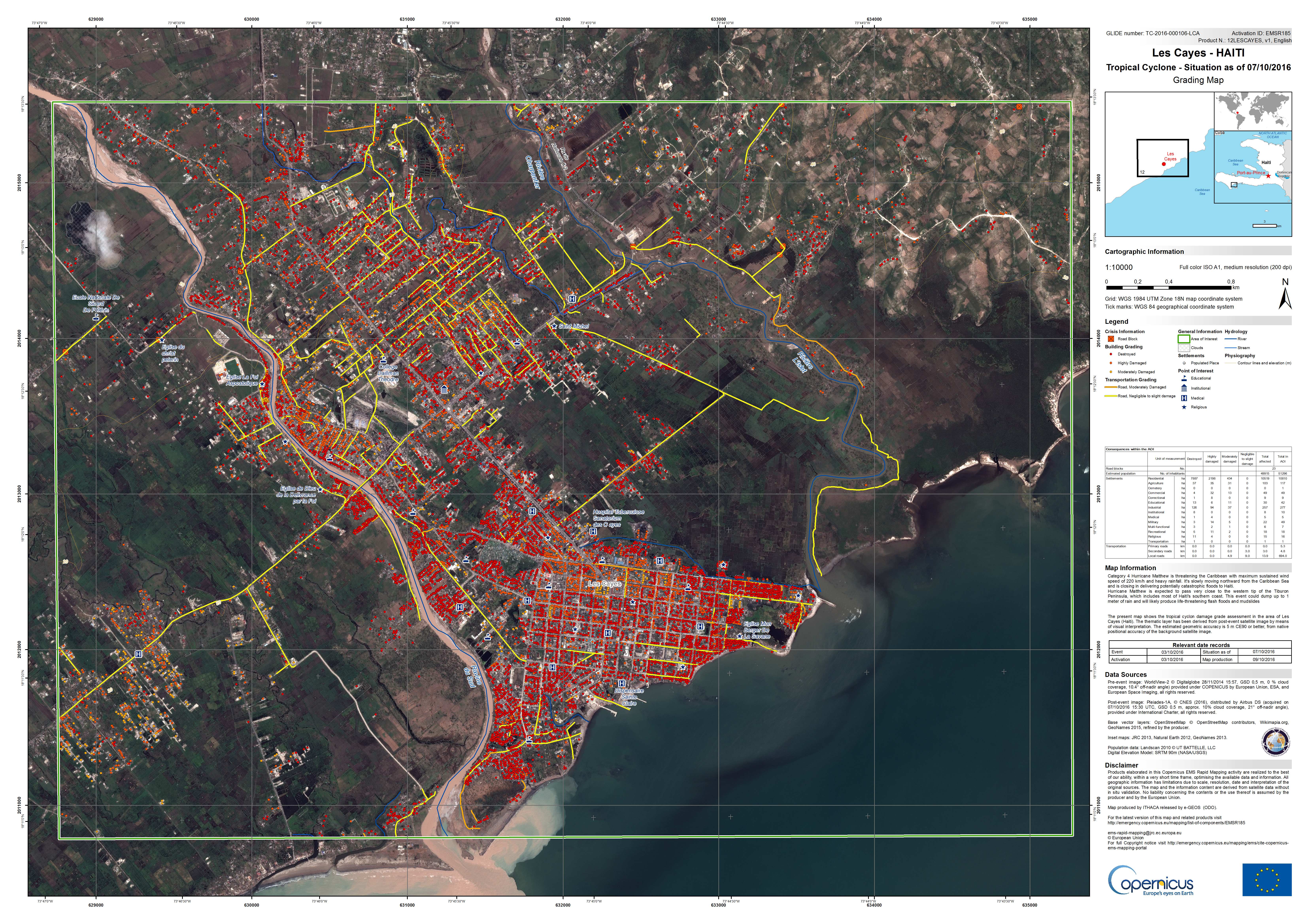
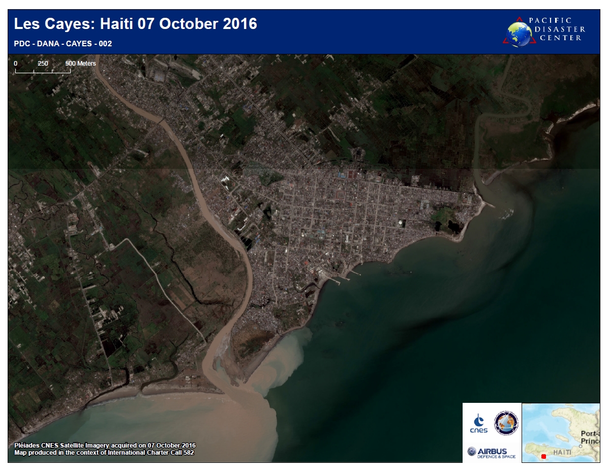
Situation in Les Cayes, Haiti on 07/10/2016
Авторские права: WorldView-2 © DigitalGlobe 2016
Pleiades © CNES 2016 - Distribution: Airbus Defence and Space, all rights reserved
Map produced by ITHACA
Information about the Product
Получено: Pre-disaster: 28/11/2014
Post-disaster: 07/10/2016
Источник: WorldView-2 / Pleiades
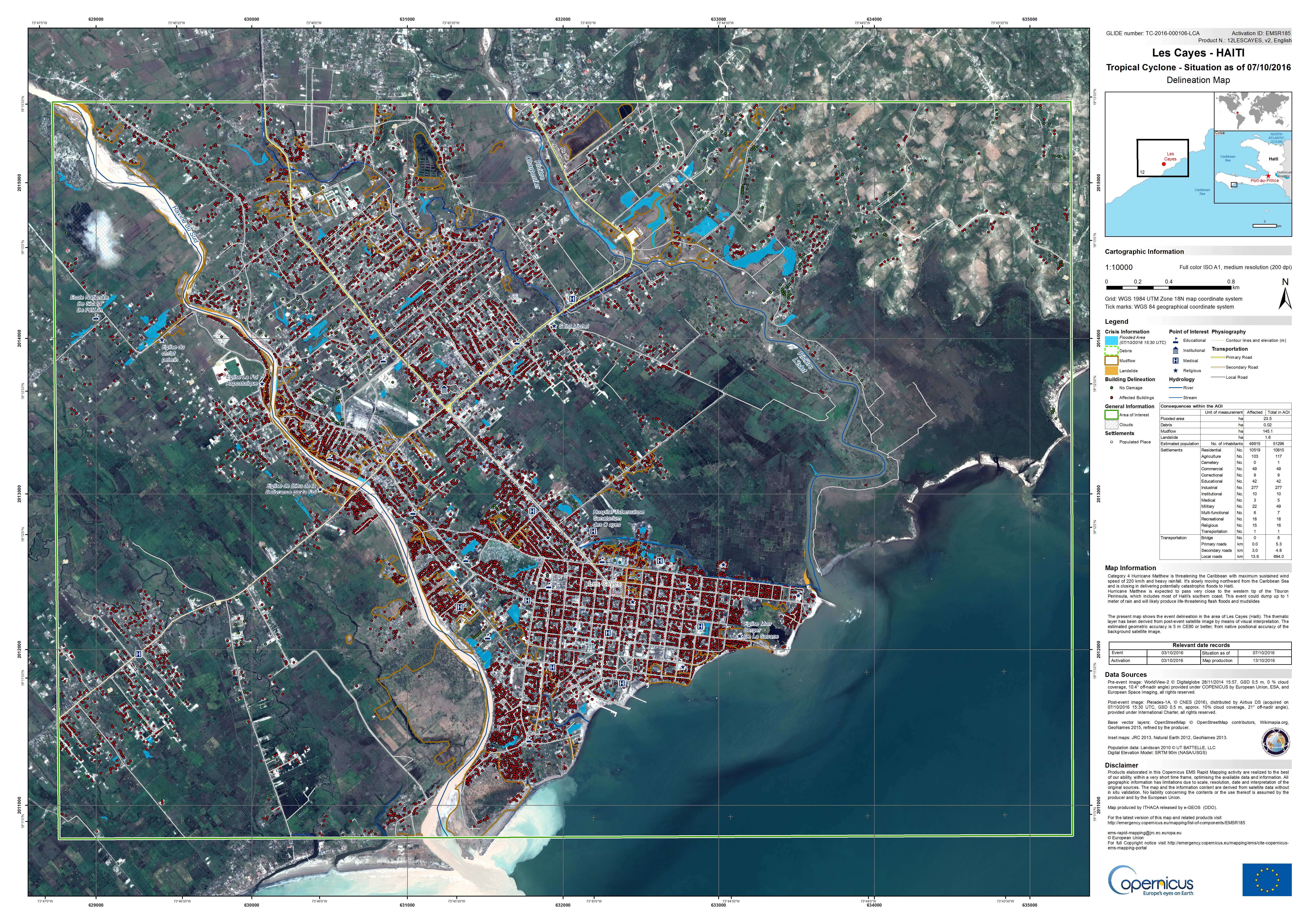

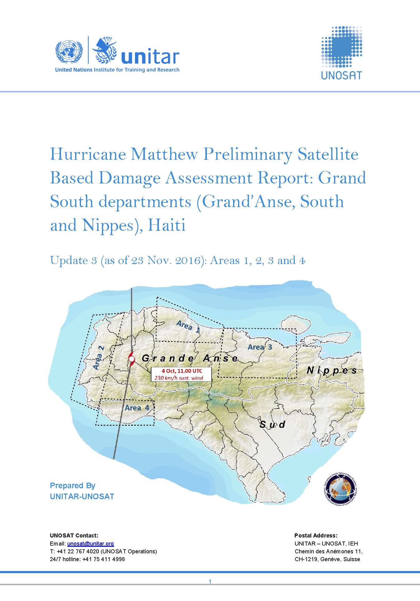
Hurricane Matthew Preliminary Satellite Based Damage Assessment Report: Grand South departments (Grand'Anse, South and Nippes), Haiti
Download the full report
Авторские права: Report produced by: UNITAR/UNOSAT
Information about the Product
Получено: Pleiades: 12/10/2016 / WorldView-1: 08/12/2014, 01/05/2015, 09/05/2015 and 16/06/2015 / WorldView-2: 9/10/2016 & 17/10/2016 / WorldView-3: 17/10/2015
Источник: Pleiades / WorldView-1 / WorldView-2 / Worldview-3
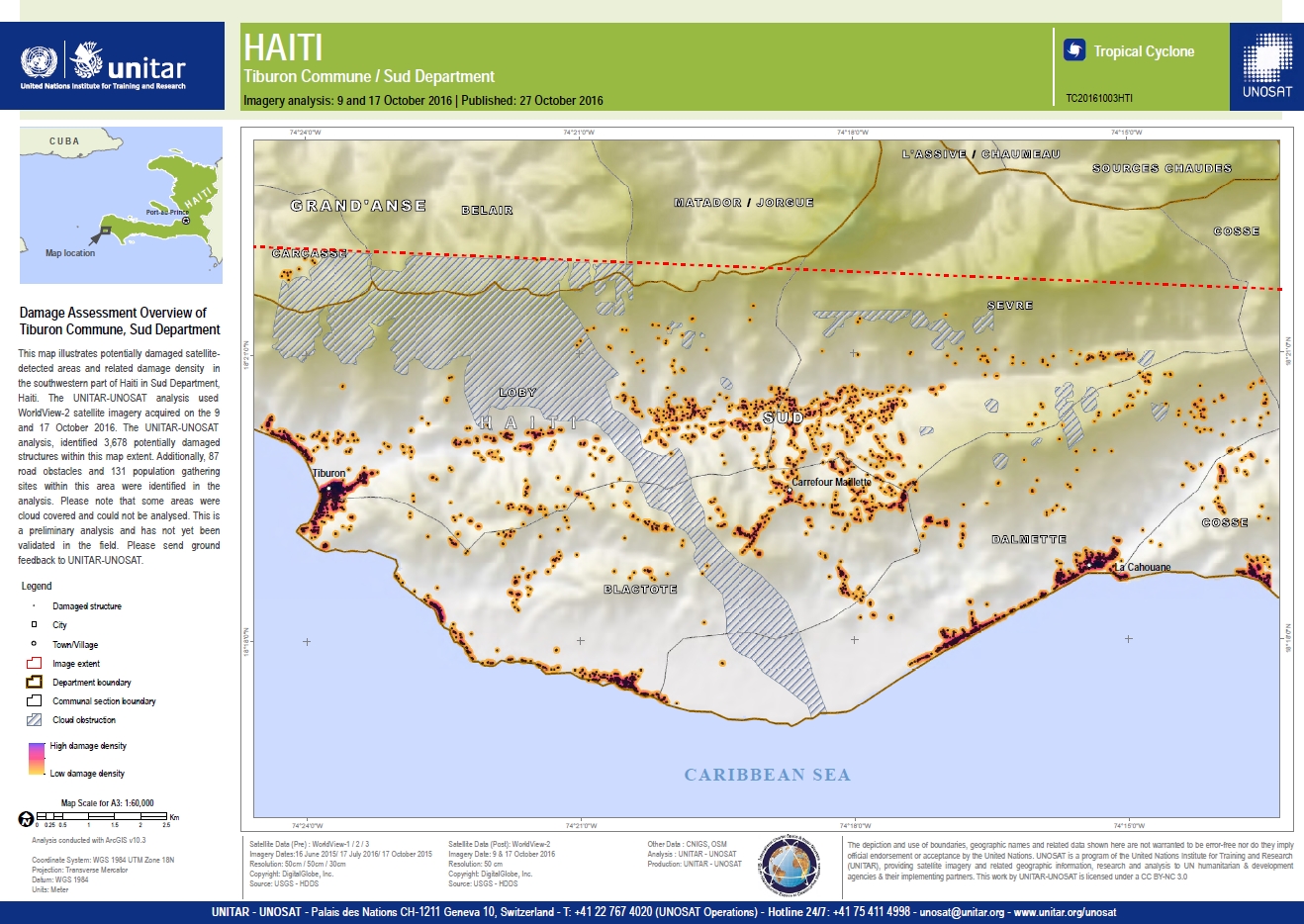
Damage assessment overview of Tiburon Commune, Sud Department
Авторские права: Worldview © DigitalGlobe 2016
Map produced by UNITAR/UNOSAT
Information about the Product
Получено: WorldView-1 / 2 / 3: 16/06/2015, 17/07/2016, 17/10/2015
WorldView-2: 09/10/2016 and 17/10/2016
Источник: WorldView-1, 2 and 3
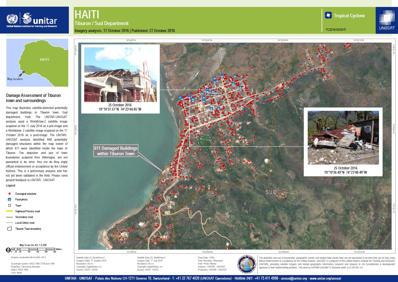
Damage assessment of Tiburon town and surroundings
Авторские права: WorldView-2 © DigitalGlobe 2016
Map produced by UNITAR/UNOSAT
Information about the Product
Получено: Pre-disaster: 17/07/2016
Post-disaster: 17/10/2016
Источник: WorldView-2
Hurricane Matthew preliminary satellite damage report - Grand'Anse Département, Haiti - Update 1
Download the full report
Авторские права: Report created by UNITAR/UNOSAT
Information about the Product
Источник: Pleiades: 07/10/2016 and 12/10/2016
WorldView-1: 01/05/2015, 09/05/2015 and 08/12/2014
WorldView-2: 17/07/2016
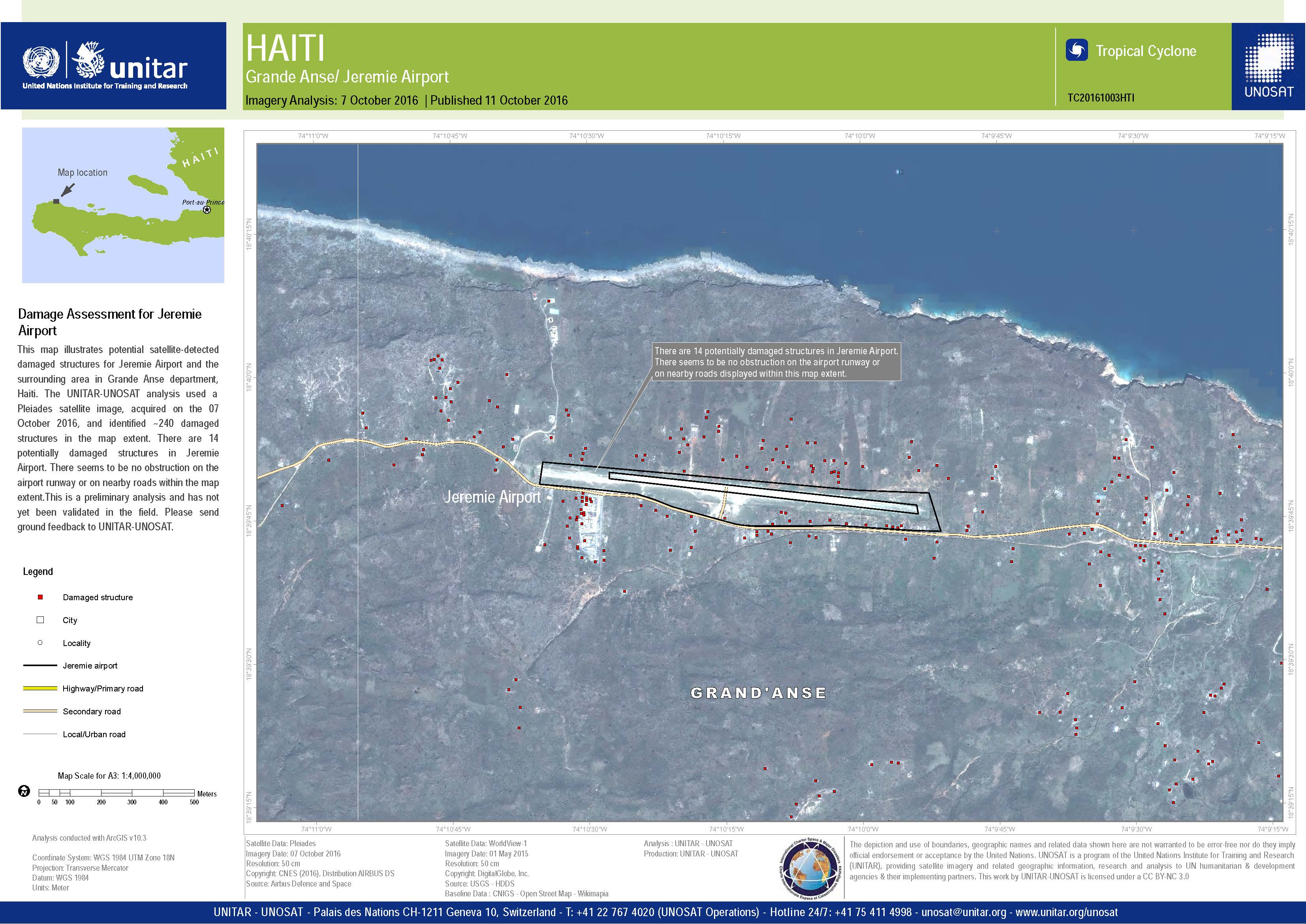
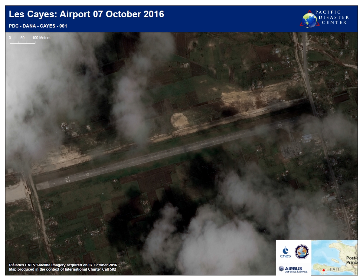
Damage assessment for Jeremie Airport
Авторские права: Pleiades © CNES 2016 - Distribution: Airbus Defence and Space, all rights reserved
Map produced by UNITAR/UNOSAT
Information about the Product
Получено: 07/10/2016
Источник: Pleiades
Hurricane Matthew preliminary satellite damage report - Grand'Anse Département, Haiti
Download the full report
Авторские права: Report produced by UNITAR/UNOSAT
Information about the Product
Получено: Pleiades: 07/10/2016
WorldView-1: 01/05/2015 and 08/12/2014
Источник: Pleiades / WorldView-1

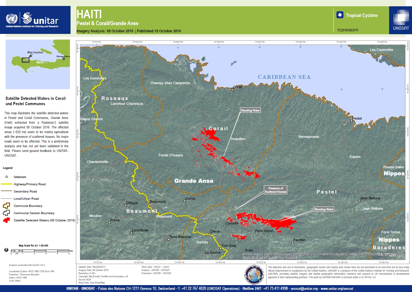
Satellite detected waters in Corail and Pestel Communes, Grande Anse, Haiti
Авторские права: RADARSAT-2 Data and Products © MacDonald, Dettwiler and Associates Ltd. (2016) - All Rights Reserved. RADARSAT is an official trademark of the Canadian Space Agency.
Map produced by UNITAR/UNOSAT
Information about the Product
Получено: 08/10/2016
Источник: RADARSAT-2

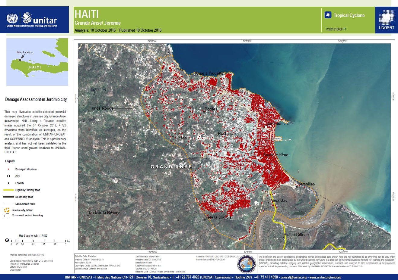
Damage assessment in Jeremie City
Авторские права: Worldview-1 © DigitalGlobe 2016
Pleiades © CNES 2016 - Distribution: Airbus Defence and Space, all rights reserved
Map produced by UNITAR/UNOSAT
Information about the Product
Получено: WorldView-1: 01/05/2015
Pleiades: 07/10/2016
Источник: WorldView-1 / Pleiades
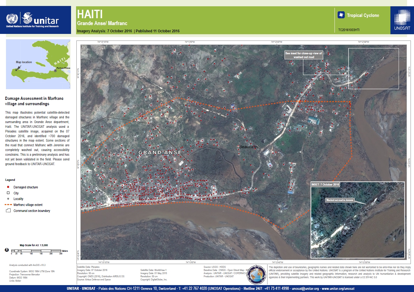
Damage assessment in Marfranc village and surroundings
Авторские права: Worldview-1 © DigitalGlobe 2016
Pleiades © CNES 2016 - Distribution: Airbus Defence and Space, all rights reserved
Map produced by UNITAR/UNOSAT
Information about the Product
Получено: WorldView-1: 01/05/2015
Pleiades: 07/10/2016
Источник: WorldView-1 / Pleiades
Damage assessment of Grande Anse and Jeremie Airport, Haiti
Авторские права: Worldview-1 © DigitalGlobe 2016
Pleiades © CNES 2016 - Distribution: Airbus Defence and Space, all rights reserved
Map produced by UNITAR/UNOSAT
Information about the Product
Получено: WorldView-1: 01/05/2015
Pleiades: 07/10/2016
Источник: WorldView-1 / Pleiades


Situation map as of 07 Oct 2016, Les Cayes West, Haiti
Авторские права: WorldView-2 © DigitalGlobe 2016
Pleiades © CNES 2016 - Distribution: Airbus Defence and Space, all rights reserved
Map produced by ITHACA
Information about the Product
Получено: Worldview-2: 28/11/2014
Pleiades: 07/10/2016
Источник: Worldview-2 / Pleiades-1A
Situation map as of 07 Oct 2016, Les Cayes North, Haiti
Авторские права: WorldView-2 © DigitalGlobe 2016
Pleiades © CNES 2016 - Distribution: Airbus Defence and Space, all rights reserved
Map produced by ITHACA
Information about the Product
Получено: Worldview-2: 28/11/2014
Pleiades: 07/10/2016
Источник: Worldview-2 / Pleiades-1A
Situation map as of 07 Oct 2016, Les Cayes Centre, Haiti
Авторские права: WorldView-2 © DigitalGlobe 2016
Pleiades © CNES 2016 - Distribution: Airbus Defence and Space, all rights reserved
Map produced by SERTIT
Information about the Product
Получено: Worldview-2: 28/11/2014
Pleiades: 07/10/2016
Источник: Worldview-2 / Pleiades-1A
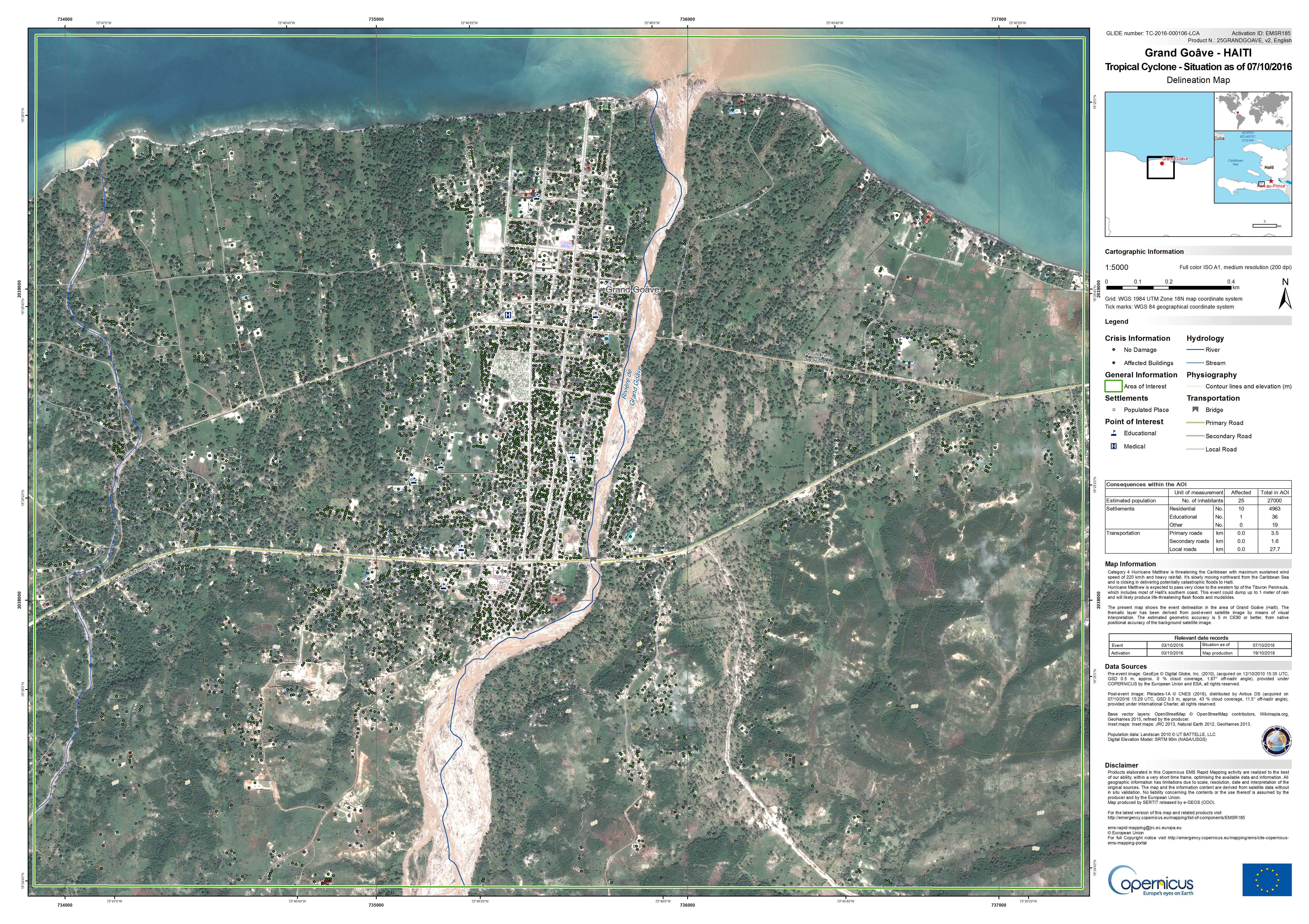
Situation map as of 07 Oct 2016, Grand Goâve, Haiti
Авторские права: GeoEye © DigitalGlobe 2016
Pleiades © CNES 2016 - Distribution: Airbus Defence and Space, all rights reserved
Map produced by SERTIT
Information about the Product
Получено: GeoEye: 12/10/2010
Pleiades: 07/10/2016
Источник: GeoEye / Pleiades
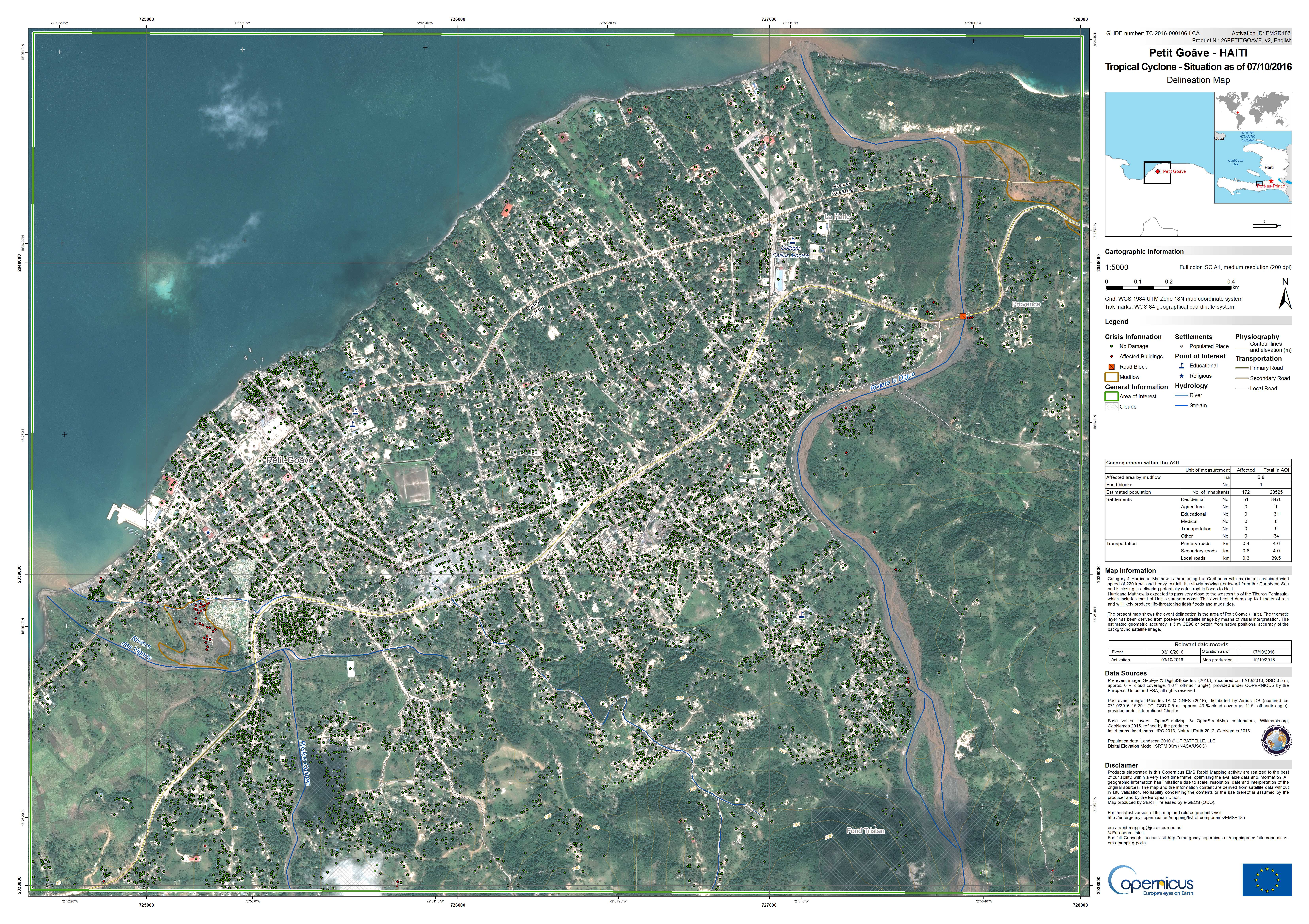
Situation map as of 07 Oct 2016, Petit-Goâve, Haiti
Авторские права: GeoEye © DigitalGlobe 2016
Pleiades © CNES 2016 - Distribution: Airbus Defence and Space, all rights reserved
Map produced by SERTIT
Information about the Product
Получено: Pre-disaster: 12/10/2010
Post-disaster: 07/10/2016
Источник: GeoEye / Pleiades
 Вернуться к полному архиву активаций

