 English
 Spanish
 French
 Chinese
 Russian
 Portuguese
 Latest Activation
Charter activations
Tropical Cyclone Mocha in Myanmar
Cyclone Mocha crashed ashore in Myanmar on 14 May 2023 at about 1:30pm (07:00 GMT). One of the most powerful storms to ever hit the region crossed the coast of northwestern Rakhine State, south of the Bangladesh border, uprooting trees, bringing down pylons and cables, and creating a tidal surge that inundated streets in the low-lying region.
Rescuers evacuated many people trapped by seawater 3.6 metres (12ft) deep along western Myanmar's coast and high winds crumpled cell phone towers during the day, cutting off communications.
At its peak intensity Saturday night and into early Sunday morning, Cyclone Mocha contained 200 mph maximum sustained winds, putting it at number two on the list of all-time strongest storms in the Bay of Bengal.
Cyclones - the equivalent of hurricanes in the North Atlantic or typhoons in the Northwest Pacific - are a regular occurance on the coast of the northern Indian Ocean where tens of millions of people live.
In May 2008, Cyclone Nargis left at least 138,000 dead or missing in Myanmar, in the country's worst natural disaster.
Related News and Resources
| Tipo de evento: | Ocean storm |
| Local do evento: | Myanmar |
| Data da Ativação da Carta: | 2023-05-11 |
| Tempo de Ativação da Carta: | 18:45 |
| Zona de Tempo da Ativação da Carta: | UTC+09:00 |
| Requisitante da Carta: | ADRC on behalf of AHA Center UNITAR on behalf of United Nations Office for the Coordination of Humanitarian Affairs (UNOCHA) | Regional Office for Asia and the Pacific |
| ID da Ativação: | 818 |
| Gerenciamento de projeto: | Angsana Chaksan (Geoinformatics Center – Asian Institute of Technology (GIC-AIT)) |
| act-value-adders: | LONGFEI LIU (NDRCC) Suwanan Sateiandee (UNOSAT) |
Products

An Assessment of Damage in Thaung Da Rar, Htee Swea and Nwar Hla Kyaw Villages, Rathedaung Town, Rakhine State, Myanmar
Direitos autorais: Includes Pleiades material © CNES (2022), Distribution Airbus DS.
Map produced by GIC - The Asian Institute of Technology.
Information about the Product
Adquirida: 19/05/2023, 28/10/2022
Fonte: Pleiades
Categoria: Grading Map

An Assessment of Damage in Sa Par Htar and La Mone Taing Villages, Rathedaung Town, Rakhine State, Myanmar
Direitos autorais: Includes Pleiades material © CNES (2023), Distribution Airbus DS.
Map produced by GIC - The Asian Institute of Technology.
Information about the Product
Adquirida: 28/10/2022, 18/05/2023, 19/05/2023 and 21/05/2023
Fonte: Pleiades
Categoria: Grading Map

An Assessment of Damage in Bar Ta Lay and Lay Gwa Son Villages, Rathedaung Town, Rakhine State, Myanmar
Direitos autorais: Includes Pleiades material © CNES (2022), Distribution Airbus DS.
Map produced by GIC - The Asian Institute of Technology.
Information about the Product
Adquirida: 28/10/2022, 18/05/2023
Fonte: Pleiades
Categoria: Grading Map

An Assessment of Damage in the Kyein Thar, Soe May and Pyaing Taung Villages, Rathedaung Town, Rakhine State, Myanmar
Direitos autorais: Includes Pleiades material © CNES (2022), Distribution Airbus DS.
Map produced by GIC - The Asian Institute of Technology.
Information about the Product
Adquirida: 28/10/2022 and 18/05/2023
Fonte: Pleiades
Categoria: Grading Map

An Assessment of Damage in the Htun Ya Wai and Pauk Taw Gyi Villages, Rathedaung Town, Rakhine State, Myanmar
Direitos autorais: Includes Pleiades material © CNES (2023), Distribution Airbus DS.
Map produced by GIC - The Asian Institute of Technology.
Information about the Product
Adquirida: 28/10/2022, 18/05/2023 and 19/05/2023
Fonte: Pleiades
Categoria: Grading Map

An Assessment of Damage in the Pyar Chaung Gyi and Pauk Taw Villages, Rathedaung Town, Rakhine State, Myanmar
Direitos autorais: Includes Pleiades material © CNES (2022), Distribution Airbus DS.
Map produced by GIC - The Asian Institute of Technology.
Information about the Product
Adquirida: 28/10/2022, 19/05/2023 and 21/05/2023
Fonte: Pleiades
Categoria: Grading Map

An Assessment of Damage in Nga Tauk Tu Chay Village, Rathedaung Town, Rakhine State, Myanmar
Direitos autorais: Includes Pleiades material © CNES (2022), Distribution Airbus DS.
Map produced by GIC - The Asian Institute of Technology.
Information about the Product
Adquirida: 28/10/2022, 18/05/2023 and 19/05/2023
Fonte: Pleiades
Categoria: Grading Map
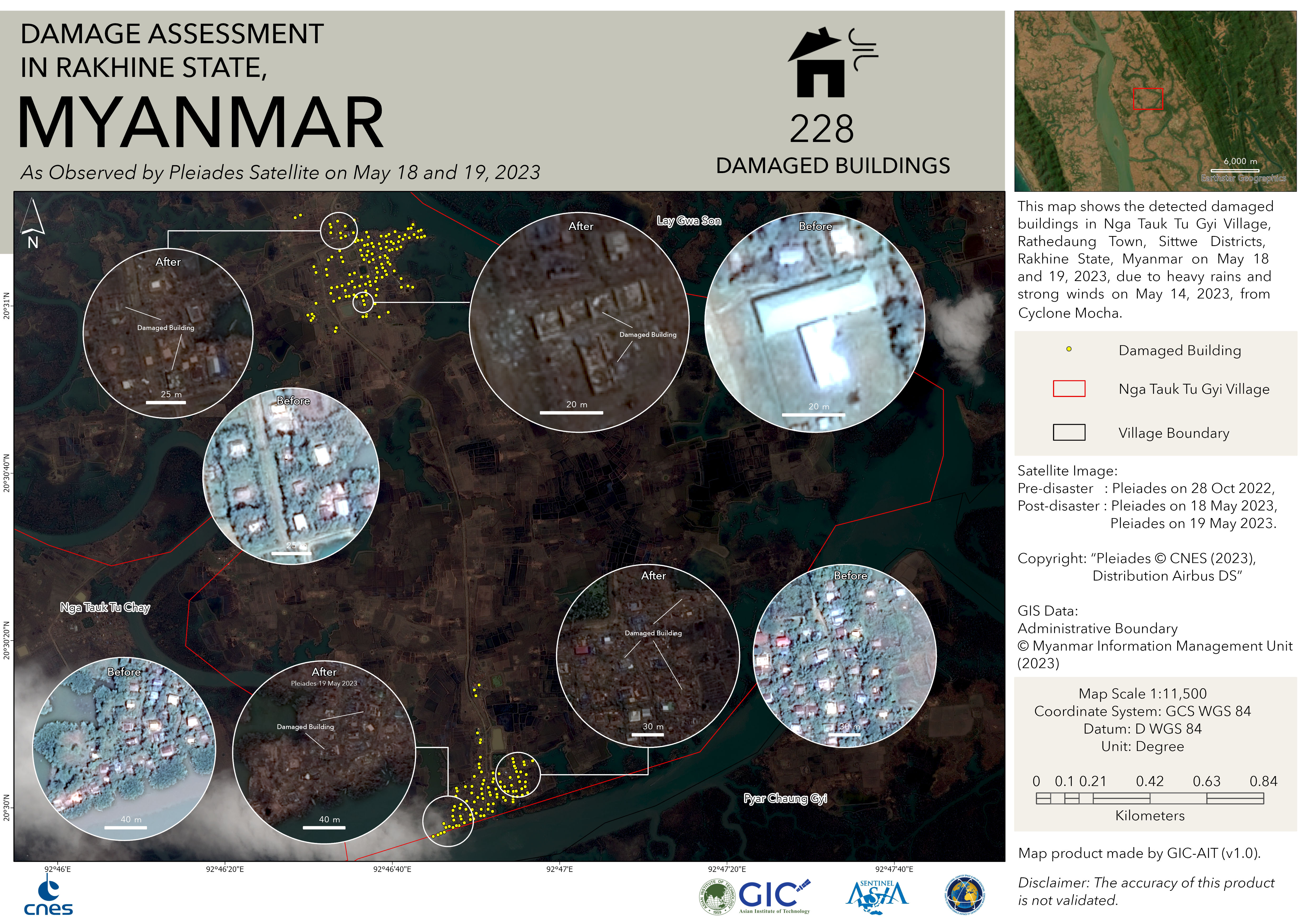
An Assessment of Damage in Nga Tauk Tu Gyi Village, Rathedaung Town, Rakhine State, Myanmar
Direitos autorais: Includes Pleiades material © CNES (2023), Distribution Airbus DS.
Map produced by GIC - The Asian Institute of Technology.
Information about the Product
Adquirida: 28/10/2022, 18/05/2023, 19/05/2023
Fonte: Pleiades
Categoria: Grading Map

An Assessment of Damage in Kha Naung Gyi Village, Rathedaung Town, Rakhine State, Myanmar
Direitos autorais: Includes Pleiades material © CNES (2022), Distribution Airbus DS.
Map produced by GIC - The Asian Institute of Technology.
Information about the Product
Adquirida: 19/05/2023, 28/10/2022
Fonte: Pleiades
Categoria: Grading Map

An Assessment of Damage in Rathedaung Town, Rakhine State, Myanmar
Direitos autorais: Includes Pleiades material © CNES (2022), Distribution Airbus DS.
Map produced by GIC - The Asian Institute of Technology.
Information about the Product
Adquirida: 28/10/2022, 19/05/2023
Fonte: Pleiades
Categoria: Grading Map

Flooded Land Type Areas in Rathedaung, Myanmar
Direitos autorais: © (2023) DigitalGlobe, Inc., Longmont CO USA 80503. DigitalGlobe and the DigitalGlobe logos are trademarks of DigitalGlobe, Inc. The use and/or dissemination of this data and/or of any product in any way derived there from are restricted. Unauthorized use and/or dissemination is prohibited
Map produced by AIR, CAS and NDRCC
Information about the Product
Adquirida: WorldView-3: 03/01/2023, 17/02/2023
WorldView-2: 22/05/2023
Fonte: WorldView-2 / WorldView-3
Categoria: Reference Map

An Assessment of Damage in Pauktaw Town, Rakhine State, Myanmar
Direitos autorais: Includes Pleiades material © CNES (2022), Distribution Airbus DS.
Map produced by GIC - The Asian Institute of Technology.
Information about the Product
Adquirida: 10/11/2022, 17/05/2023
Fonte: Pleiades
Categoria: Grading Map

An Assessment of Damage in Ponnagyun Town, Rakhine State, Myanmar
Direitos autorais: Includes Pleiades material © CNES (2022), Distribution Airbus DS.
Map produced by GIC - The Asian Institute of Technology.
Information about the Product
Adquirida: 10/11/2022, 17/05/2023
Fonte: Pleiades
Categoria: Grading Map

Flooded Areas in Rakhine, Myanmar due to Tropical Cyclone Mocha
Download the Full Report
Direitos autorais: © CNSA/CRESDA (2023)
Maps produced by the National Disaster Reduction Center of China.
Information about the Product
Adquirida: 20/05/2023
Fonte: GF-1
Categoria: Delineation Map

 Voltar ao arquivo completo da Ativação

