 English
 Spanish
 French
 Chinese
 Russian
 Portuguese
 Latest Activation
Charter activations
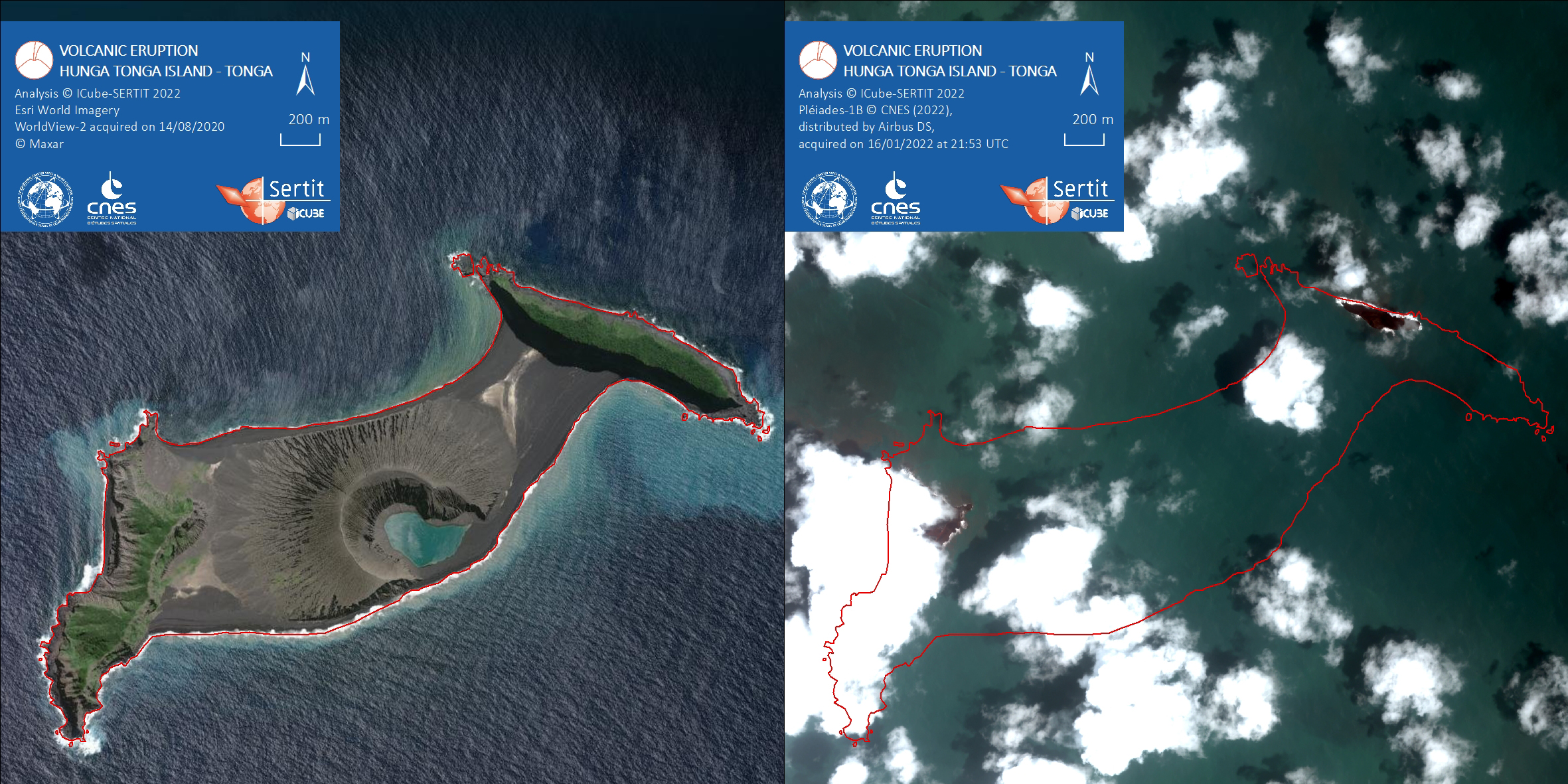
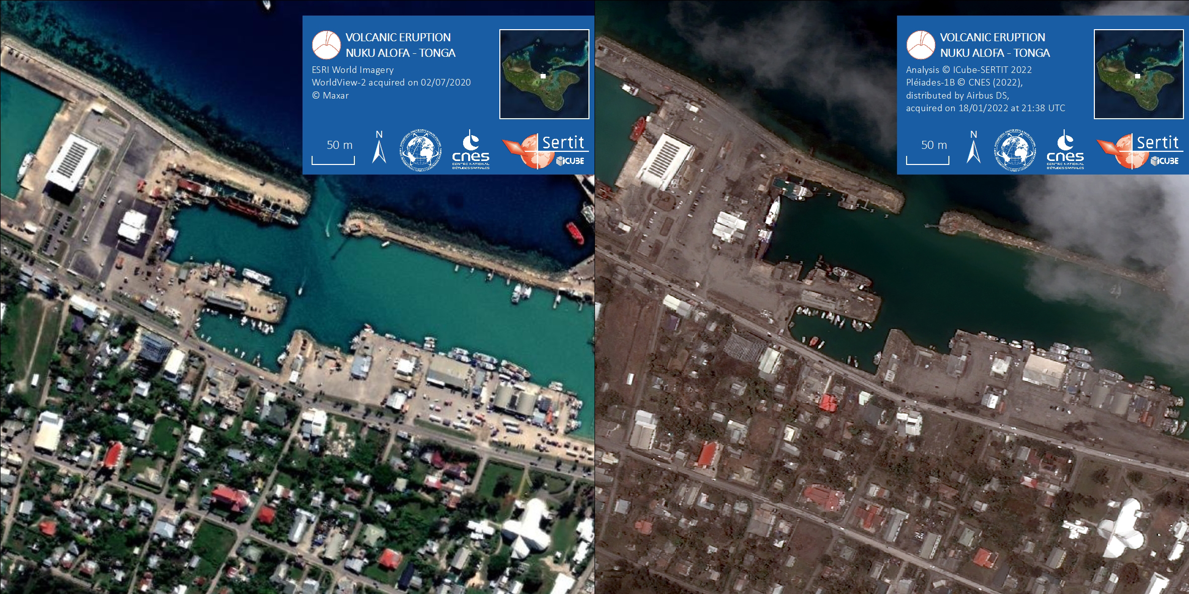
Volcanic eruption in Tonga and the Pacific
An underwater volcano in the South Pacific erupted violently causing tsunamis to hit Hawaii, Japan, and Tonga's largest island, Tongatapu sending waves flooding into the capital.
The Hunga-Tonga-Hunga-Ha'apai volcano, about 30 kilometers (18.6 miles) southeast of Tonga's Fonuafo'ou island, first erupted on Friday 14 Janurary and a second time on Saturday 15 January around 5:26 p.m. local time, according to media reports. The eruptions sent a plume of ash, gas and steam 20 kilometers (12.4 miles) into the air,
Satellite imagery showed a massive ash cloud and shockwaves spreading from the eruption. Ash was falling from the sky in the Tonga capital, Nuku'alofa, Saturday evening and phone connections were down. The eruption was likely the biggest recorded anywhere on the planet in more than 30 years, according to experts.
Related News and Resources
| Local do evento: | Tonga |
| Data da Ativação da Carta: | 2022-01-15 |
| Tempo de Ativação da Carta: | 16:35 |
| Zona de Tempo da Ativação da Carta: | UTC+01:00 |
| Requisitante da Carta: | UNITAR on behalf of United Nations Office for the Coordination of Humanitarian Affairs (OCHA) | Regional Office for Asia and the Pacific |
| ID da Ativação: | 744 |
| Gerenciamento de projeto: | UNITAR |
Products

The impact of Tonga volcanic eruption on the vegetation of the surrounding islands
Download full report
Direitos autorais: © Planet Labs Inc. (2022)
map produced by CNES
Information about the Product
Adquirida: 14/01/2022, 16/01/2022
Fonte: PlanetScope
Categoria: Delineation Map
Preliminary analysis of InSAR displacements for the Tonga 2022 eruption
Download full report
Direitos autorais: Contains modified Copernicus Sentinel data (2022)
Map produced by British Geological Survey
Information about the Product
Adquirida: Sentinel-1: 22/12/2021, 03/01/2022
Sentinel-2: 28/11/2021, 17/01/2022
Fonte: Sentinel-1, Sentinel-2
Categoria: Delineation Map

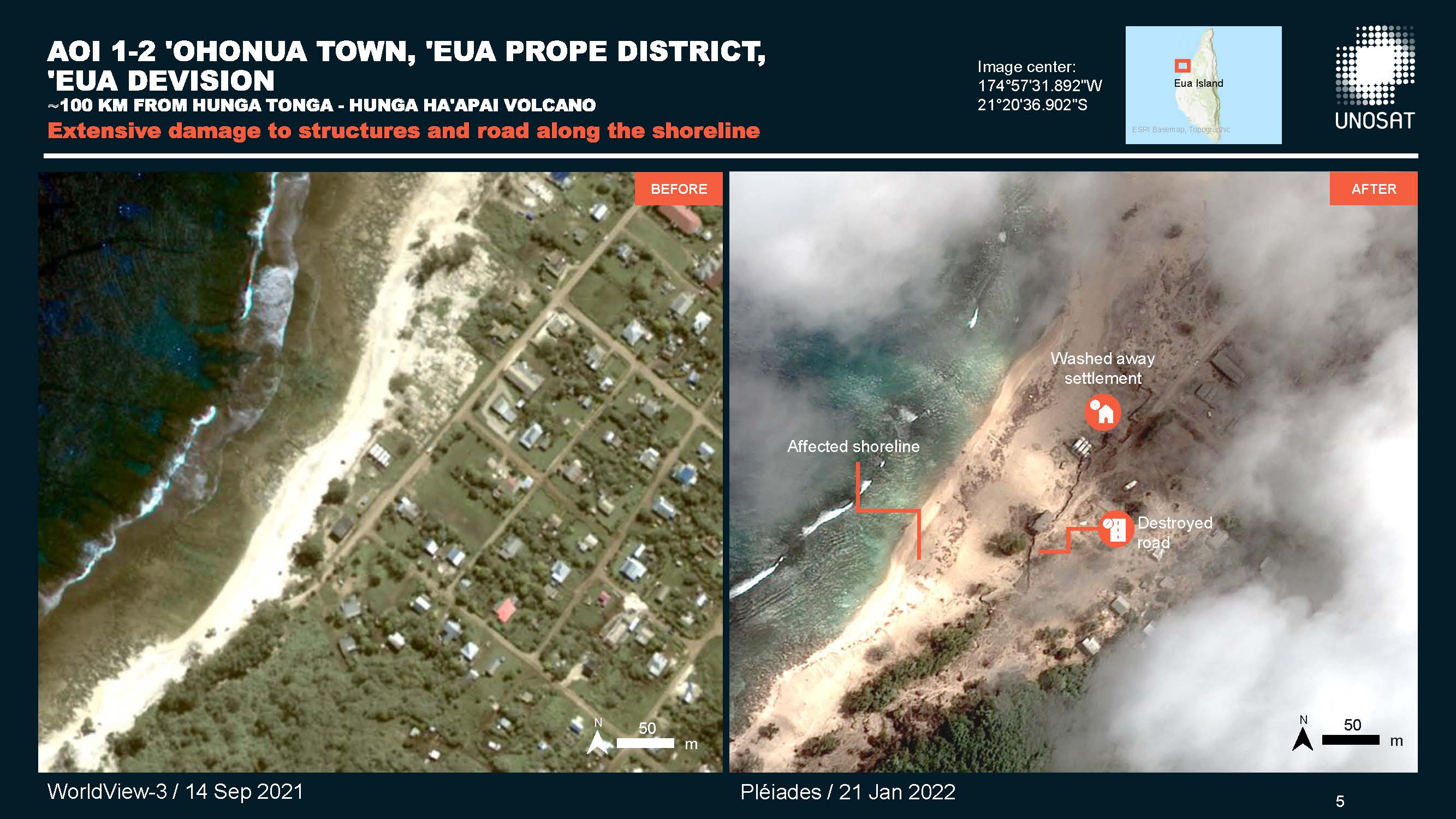
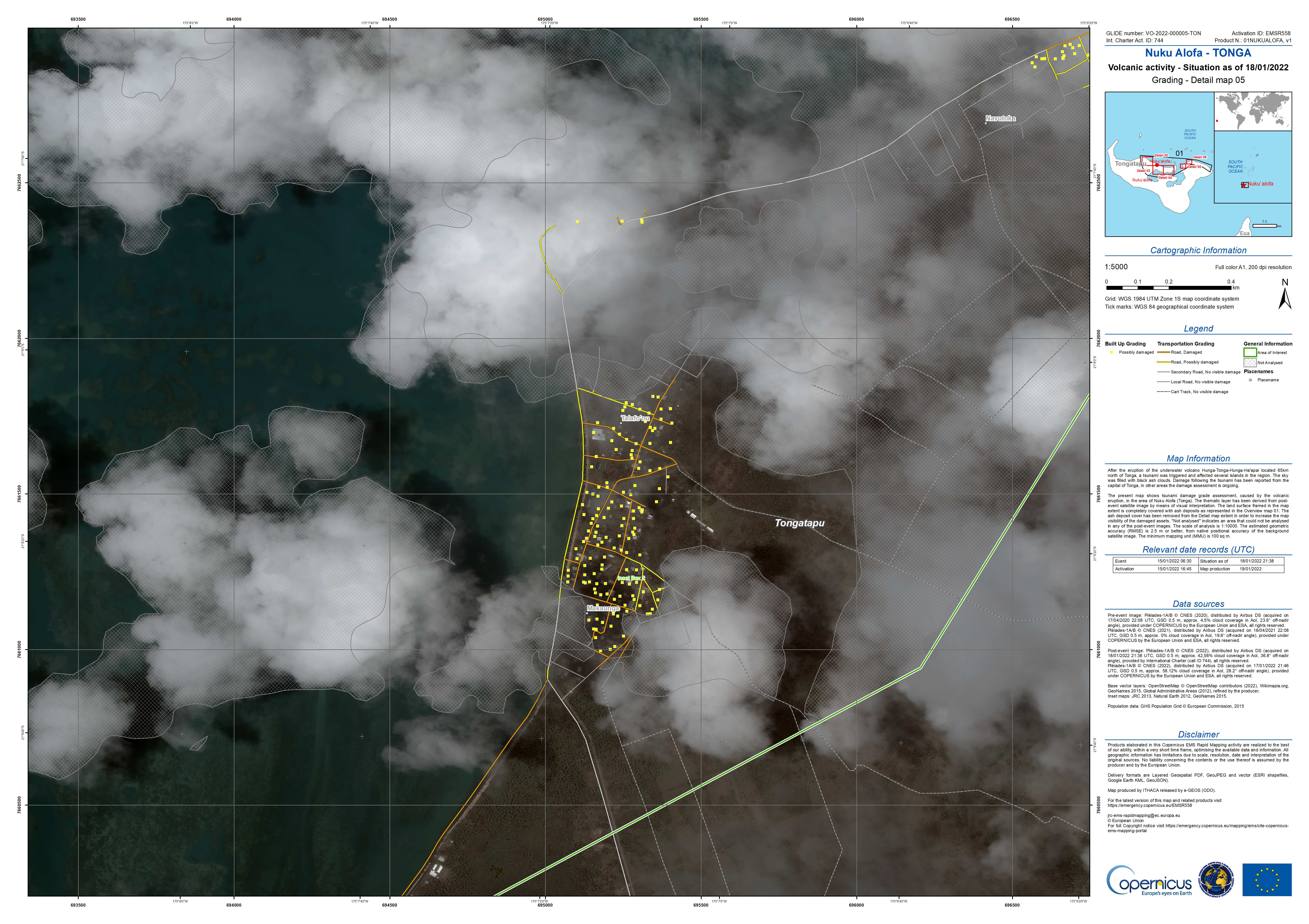
Damage assessment in 'Ohonua town, 'Eua Prope district, 'Eua division, Tonga
Direitos autorais: Includes Pleiades material © CNES (2022), Distribution Airbus DS.
WorldView-3 © (2021) DigitalGlobe, Inc., Longmont CO USA 80503. DigitalGlobe and the DigitalGlobe logos are trademarks of DigitalGlobe, Inc. The use and/or dissemination of this data and/or of any product in any way derived there from are restricted. Unauthorized use and/or dissemination is prohibited.
Map produced by UNITAR/UNOSAT
Information about the Product
Adquirida: Pleiades: 19/01/2022 and 20/01/2022
WorldView-3: 14/09/2021
Fonte: Pleiades / WorldView-3
Categoria: Grading Map
Damage Assessment, of 'Eua Island, Tonga, following Hunga Tonga-Hunga Ha'apai volcanic eruption
Download the full report
Direitos autorais: Contains modified Copernicus Sentinel data (2022)
WorldView-3 © (2021) DigitalGlobe, Inc., Longmont CO USA 80503. DigitalGlobe and the DigitalGlobe logos are trademarks of DigitalGlobe, Inc. The use and/or dissemination of this data and/or of any product in any way derived there from are restricted. Unauthorized use and/or dissemination is prohibited.
Includes Pleiades material © CNES (2022), Distribution Airbus DS.
Report produced by UNITAR/UNOSAT
Information about the Product
Adquirida: Sentinel-2: 14/01/2022 and 19/01/2022
WorldView-3: 14/09/2021
Pleiades: 20/01/2022
Fonte: Sentinel-2 / WorldView-3 / Pleiades
Categoria: Grading Map

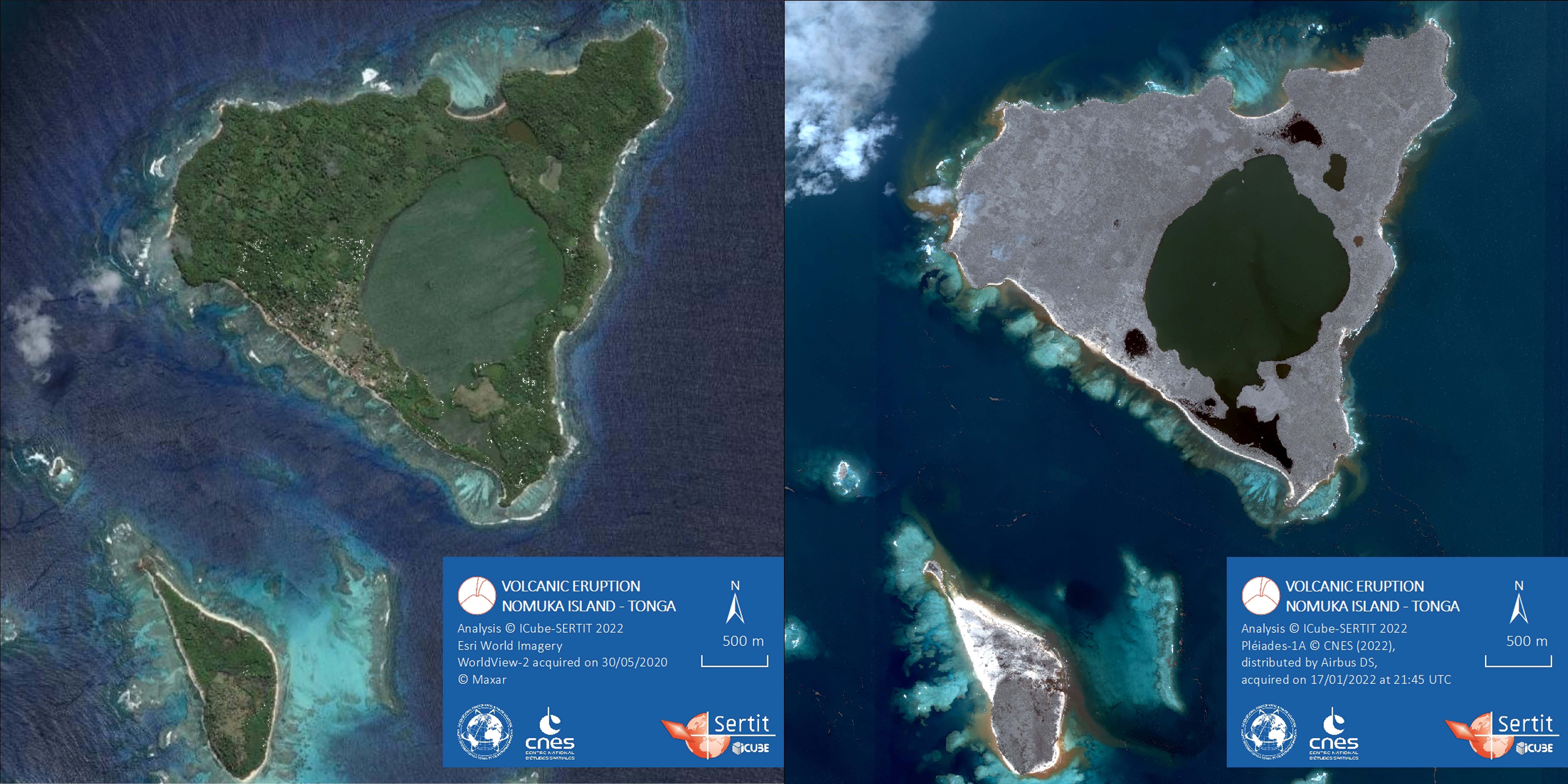
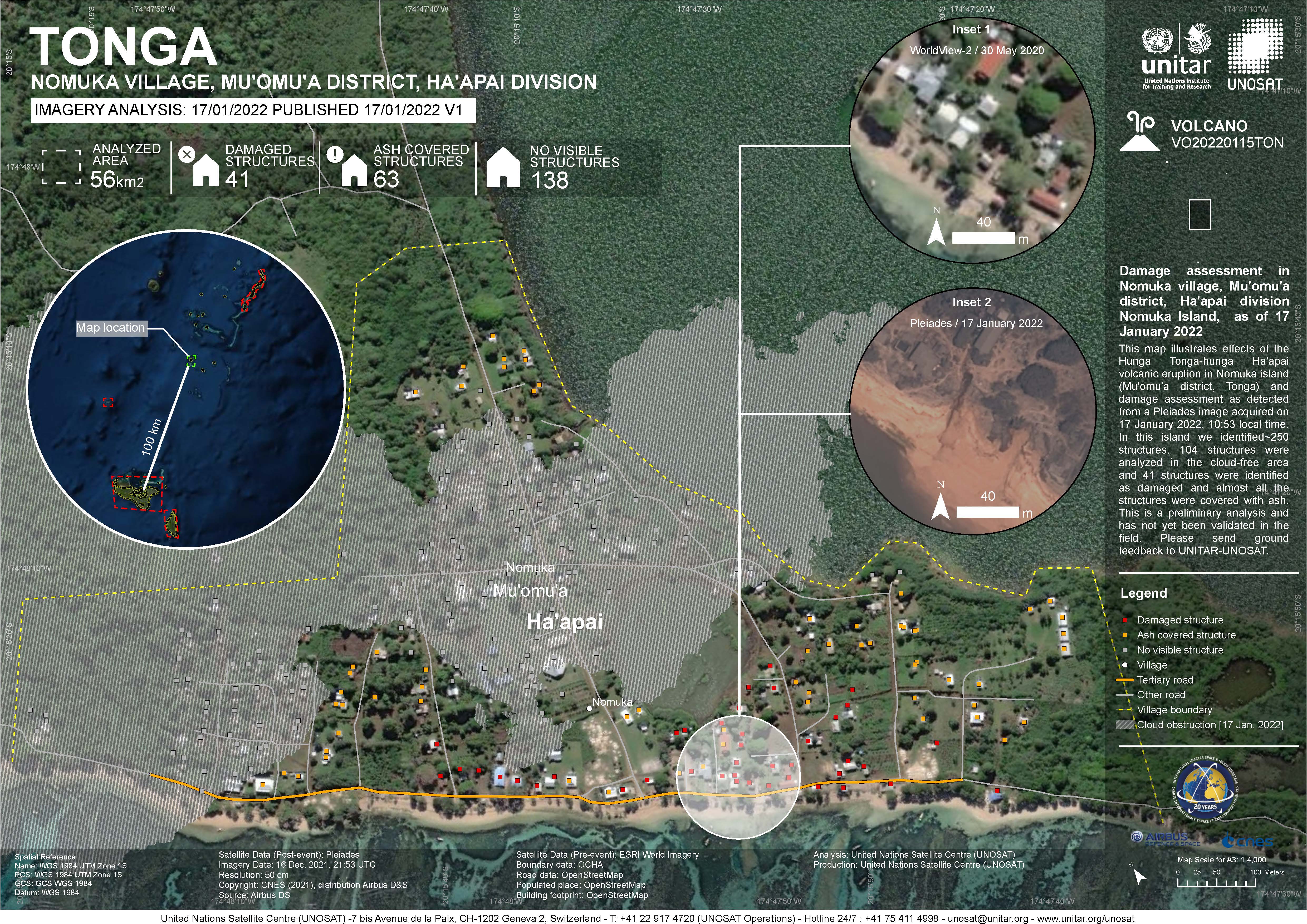
Damage assessment in Nomuka Island, Mu'omu'a district, Ha'apai division,Tonga
Direitos autorais: WorldView-2 © (2022) DigitalGlobe, Inc., Longmont CO USA 80503. DigitalGlobe and the DigitalGlobe logos are trademarks of DigitalGlobe, Inc. The use and/or dissemination of this data and/or of any product in any way derived there from are restricted. Unauthorized use and/or dissemination is prohibited.
Includes Pleiades material © CNES (2022), Distribution Airbus DS.
Map produced by UNITAR / UNOSAT
Information about the Product
Adquirida: WorldView-2: 13/11/2021
Pleiades: 17/01/2022
Fonte: WorldView-2, Pleiades
Categoria: Reference Map

Damage assessment in Mango Island, Mu'omu'a district, Ha'apai division, Tonga
Direitos autorais: WorldView-2 © (2022) DigitalGlobe, Inc., Longmont CO USA 80503. DigitalGlobe and the DigitalGlobe logos are trademarks of DigitalGlobe, Inc. The use and/or dissemination of this data and/or of any product in any way derived there from are restricted. Unauthorized use and/or dissemination is prohibited
KOMPSAT-3 © KARI (2022).
Kanopus-V © NTs OMZ (2022), All Rights Reserved
Map produced by UNITAR / UNOSAT
Information about the Product
Adquirida: WorldView-2: 21/11/2021
KOMPSAT-3: 18/01/2022
Kanopus-V: 18/01/2022
Fonte: WorldView-2, KOMPSAT-3, Kanopus-V
Categoria: Gradient Monitoring Maps


Damage assessment in Mango Island, Mu'omu'a district, Ha'apai division, Tonga
Direitos autorais: Kanopus-V © NTs OMZ (2022), All Rights Reserved
KOMPSAT-3 © KARI (2022).
WorldView-2 © (2022) DigitalGlobe, Inc., Longmont CO USA 80503. DigitalGlobe and the DigitalGlobe logos are trademarks of DigitalGlobe, Inc. The use and/or dissemination of this data and/or of any product in any way derived there from are restricted. Unauthorized use and/or dissemination is prohibited.
Map produced by UNITAR / UNOSAT
Information about the Product
Adquirida: WorldView-2: 21/11/2021
Kanopus-V: 18/01/2022
KOMPSAT-3: 18/01/2022
Fonte: Kanopus-V, KOMPSAT-3, WorldView-2
Categoria: Reference Map


Preliminary Satellite Derived Damage Assessment - Volcanic Eruption and induced tsunami in Mango Island Tonga
Download the full report
Direitos autorais: Kanopus-V © NTs OMZ (2022), All Rights Reserved
WorldView-2 © (2022) DigitalGlobe, Inc., Longmont CO USA 80503. DigitalGlobe and the DigitalGlobe logos are trademarks of DigitalGlobe, Inc. The use and/or dissemination of this data and/or of any product in any way derived there from are restricted. Unauthorized use and/or dissemination is prohibited
KOMPSAT-3 © KARI (2022).
Map produced by UNITAR / UNOSAT
Information about the Product
Adquirida: Kanopus-V: 17/01/2022
KOMPSAT-3: 18/01/2022
WorldView-2: 21/11/2021
Fonte: Kanopus-V, WorldView-2 / KOMPSAT-3
Categoria: Grading Map

Satellite-Derived Damage Observation by Volcanic Eruption and induced tsunami, Hunga Tonga-hunga Ha'apai Volcano
Download the full report
Direitos autorais: WorldView-2 © (2020) DigitalGlobe, Inc., Longmont CO USA 80503. DigitalGlobe and the DigitalGlobe logos are trademarks of DigitalGlobe, Inc. The use and/or dissemination of this data and/or of any product in any way derived there from are restricted. Unauthorized use and/or dissemination is prohibited
JILIN-1 © CGSTL (2022)
GF-1 © CNSA/CRESDA (2022)
Contains modified Copernicus Sentinel data (2022)
Map produced by CASC and Second Institute of Oceanography, MNR, China
Information about the Product
Adquirida: WorldView-2: 14/05/2020
GF-1: 16/01/2022
JILIN-1: 17/01/2022
Sentinel-2: 17/01/2022
Fonte: WorldView-2, JILIN-1, GF-1 (Gaofen-1), Sentinel-2
Categoria: Reference Map
Volcanic Eruption of the 15 January 2022 and induced tsunami, Hunga Tonga-hunga Ha'apai Volcano- Preliminary Satellite-Derived Assessment Download the full report
Direitos autorais: Contains modified Copernicus Sentinel data (2021)
Includes Pleiades material © CNES (2022), Distribution Airbus DS.
Map produced by UNITAR / UNOSAT
Information about the Product
Adquirida: Sentinel-2: 08/12/2021
Pleiades: 16/01/2022
Fonte: Sentinel-2, Pleiades
Categoria: Reference Map
 Voltar ao arquivo completo da Ativação

