 English
 Spanish
 French
 Chinese
 Russian
 Portuguese
 Latest Activation
Charter activations
Flood in Brazil
Heavy rain caused flooding in the state of Rio de Janeiro, Brazil. Officials stated the rate of rainfall - as much as 655 millimeters in 48 hours - was record-breaking for the region.
At least 16 casualties were reported, in Angra dos Reis, Paraty, and Mesquita.
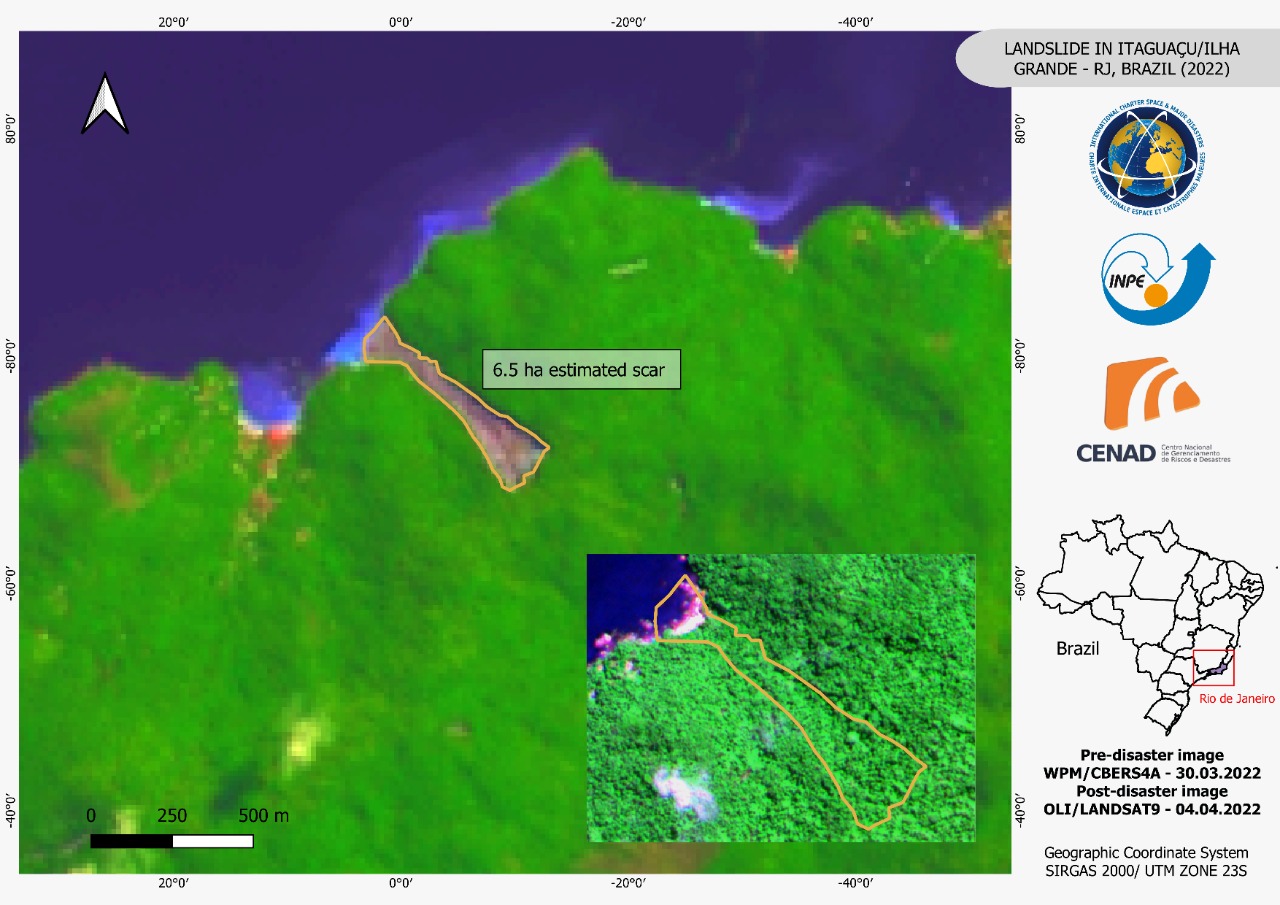
In Angra dos Reis, a landslide destroyed several homes leaving eight dead. Ilha Grande was also affected badly, where landslides hit several areas and Praia de Itaguaçu was submerged.
A state of emergency was declared on 2 April, and first responders began a search in the affected areas. Landslides made this difficult in some locations, as roads were blocked by debris.
| Tipo de evento: | Flood and landslide |
| Local do evento: | Brazil |
| Data da Ativação da Carta: | 2022-04-05 |
| Tempo de Ativação da Carta: | 11:01 |
| Zona de Tempo da Ativação da Carta: | UTC-03:00 |
| Requisitante da Carta: | CENAD |
| ID da Ativação: | 754 |
| Gerenciamento de projeto: | CENAD |
Products
Carried Sediments in Monsuaba beach / Angra Dos Reis, Brazil
Direitos autorais: Includes Pleiades material © CNES (2022), Distribution Airbus DS.
Google Maps - Satellite (Maxar Technologies)
Map produced by CENAD
Information about the Product
Adquirida: Google Satellite (Maxar Technologies): 16/08/2021
Pleiades: 08/04/2022
Fonte: Pleiades / Google (Maxar Technologies)
Categoria: Reference Map
Landslides in Garatucaia/Angra Dos Reis - Rio De Janiro Brazil
Direitos autorais: Google Satellite (Maxar Technologies)
Includes Pleiades material © CNES (2022), Distribution Airbus DS.
Map produced by CENAD
Information about the Product
Adquirida: Google (Maxar Technologies): 16/08/2021
Pleiades: 08/04/2022
Fonte: Pleiades / Google Satellite (Maxar Technologies)
Categoria: Reference Map
Landslides in "Praia de Ponta Negra" Paraty - Rio de Janeiro - Brazil
Direitos autorais: Esri, Maxar, GeoEye, Earthstar Geographics, CNES/Airbus DS, USDA, USGS, AeroGRID, IGN, and the GIS User Community
Includes Pleiades material © CNES (2022), Distribution Airbus DS.
Map produced by CENAD
Information about the Product
Adquirida: Pre-disaster imagery: 22/02/2022
Pleiades: 10/04/2022
Fonte: Pleiades
Categoria: Delineation Map
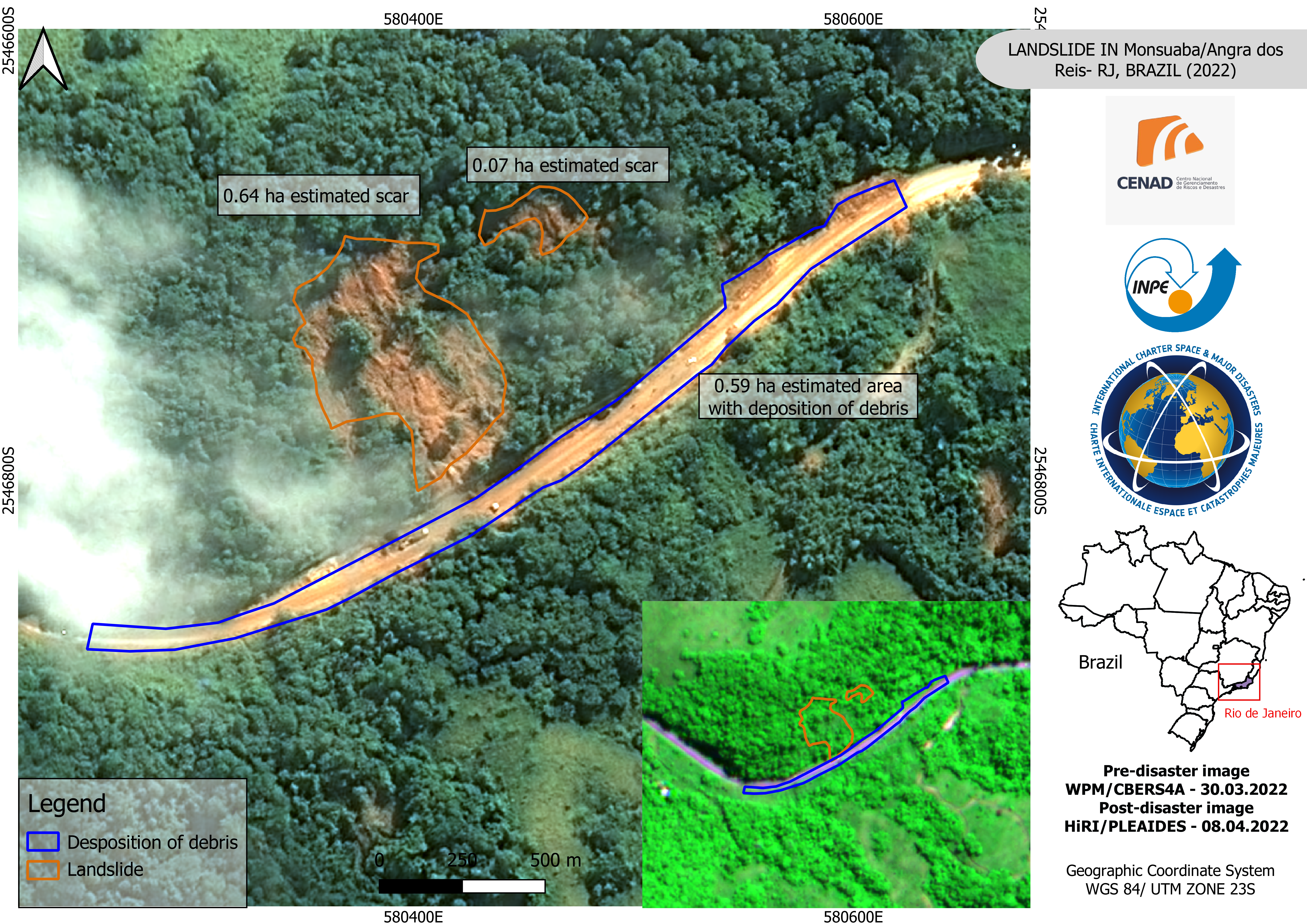
Landslide in Monsuaba/Angra dos Reis - RJ, Brazil (2022)
Direitos autorais: Includes Pleiades material © CNES (2022), Distribution Airbus DS.
copyright (2022) INPE
Map produced by CENAD
Information about the Product
Adquirida: CBERS-4: 30/03/2022
Pleiades: 08/04/2022
Fonte: Pleiades / CBERS-4
Categoria: Delineation Map
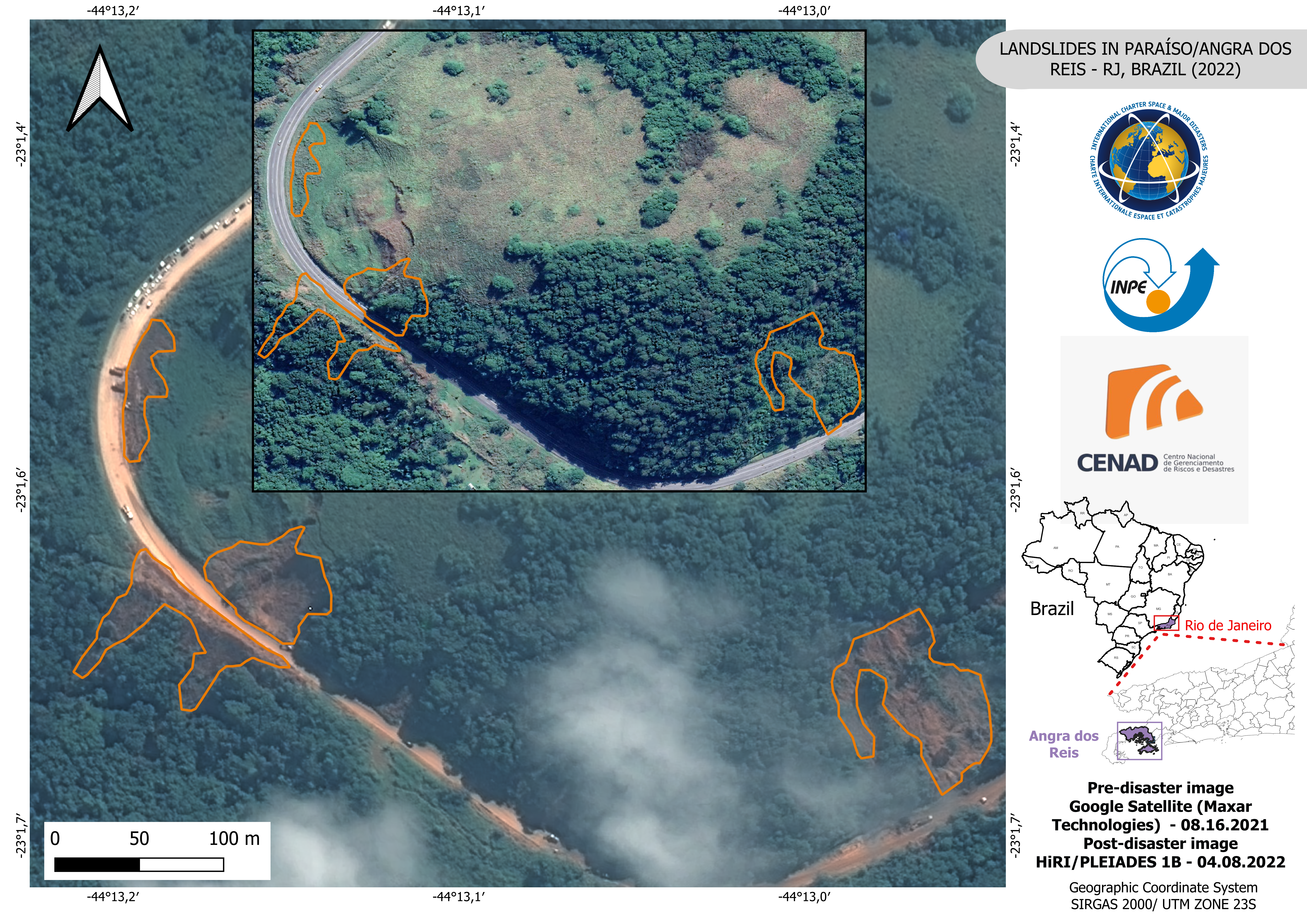
Landslides in Paraíso/Angra dos Reis - RJ, Brazil
Direitos autorais: Includes Pleiades material © CNES (2022), Distribution Airbus DS.
Google Satellite (Maxar Technologies)
Map produced by CENAD
Information about the Product
Adquirida: Google Satellite (Maxar Technologies): 16/08/2021
Pleiades: 08/04/2022
Fonte: Pleiades / Google Satellite (Maxar Technologies)
Categoria: Reference Map

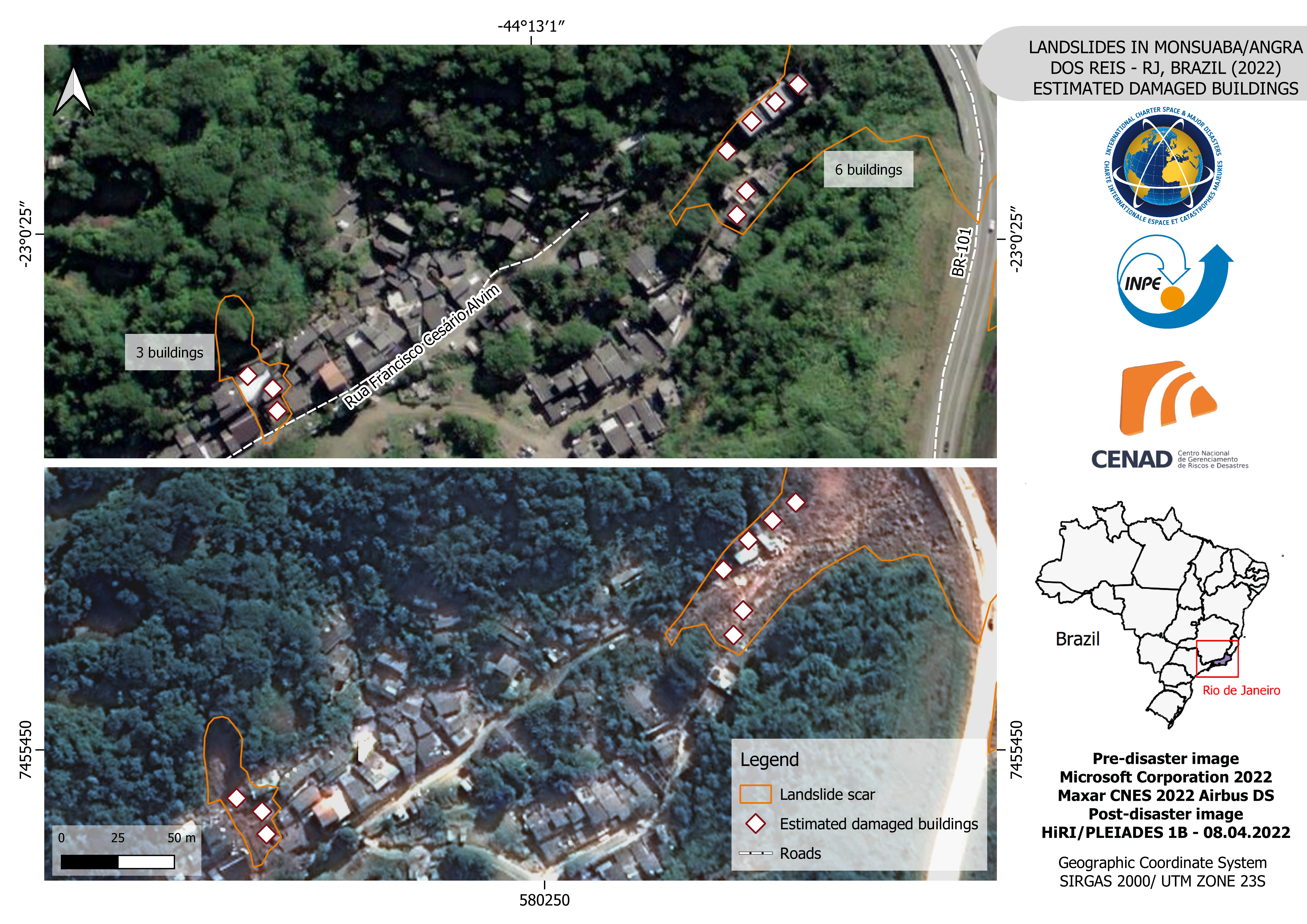
Landslides in Monsuaba neighborhood, Angra dos Reis - RJ, Brazil
Direitos autorais: Includes Pleiades material © CNES (2022), Distribution Airbus DS.
copyright (2022) INPE
Map produced by CENAD
Information about the Product
Adquirida: CBERS-4: 30/03/2022
Pleiades: 08/04/2022
Fonte: Pleiades / CBERS-4
Categoria: Delineation Map
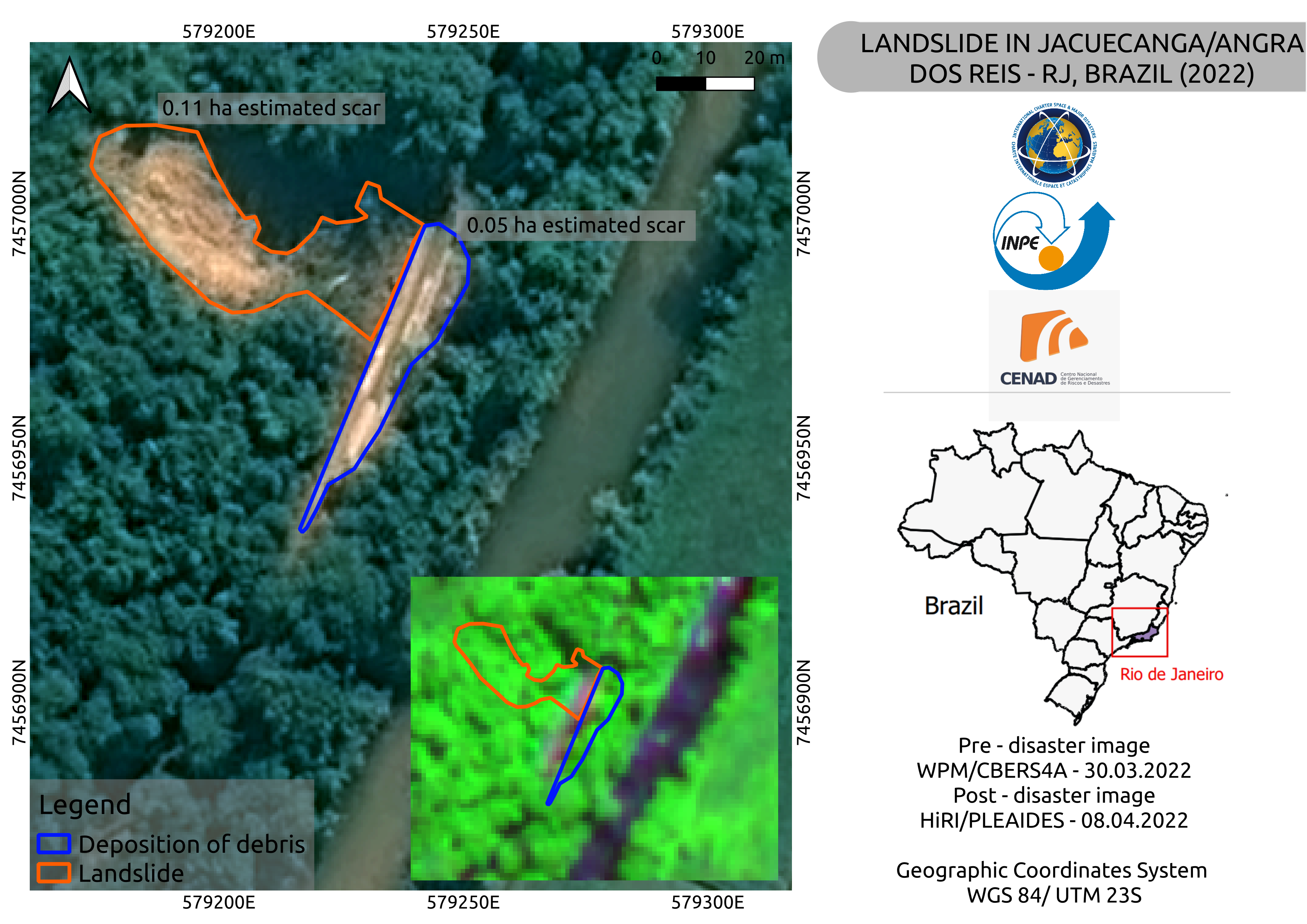
Landslide in Jacuecanga/Angra dos reis - RJ/ Brazil
Direitos autorais: Includes Pleiades material © CNES (2022), Distribution Airbus DS.
Copyright (2022) INPE
Map produced by CENAD
Information about the Product
Adquirida: CBERS-4: 30/03/2022
Pleiades: 07/04/2022
Fonte: Pleiades / CBERS-4
Categoria: Delineation Map
 Voltar ao arquivo completo da Ativação

