 English
 Spanish
 French
 Chinese
 Russian
 Portuguese
 Latest Activation
Charter activations
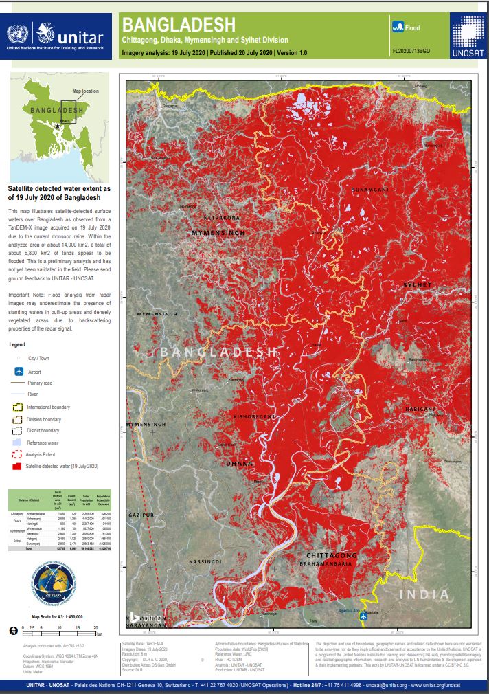
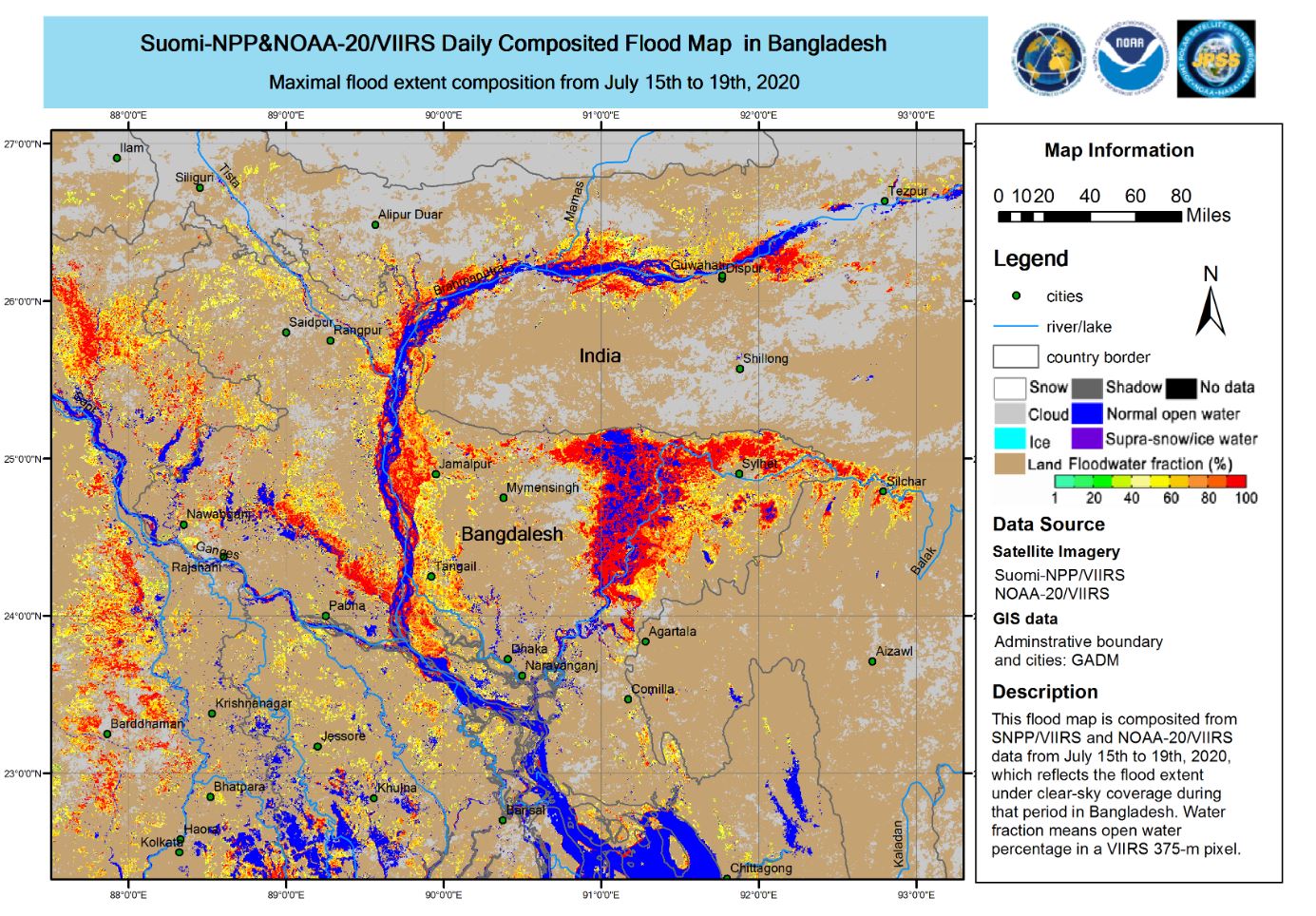
Flood in Bangladesh
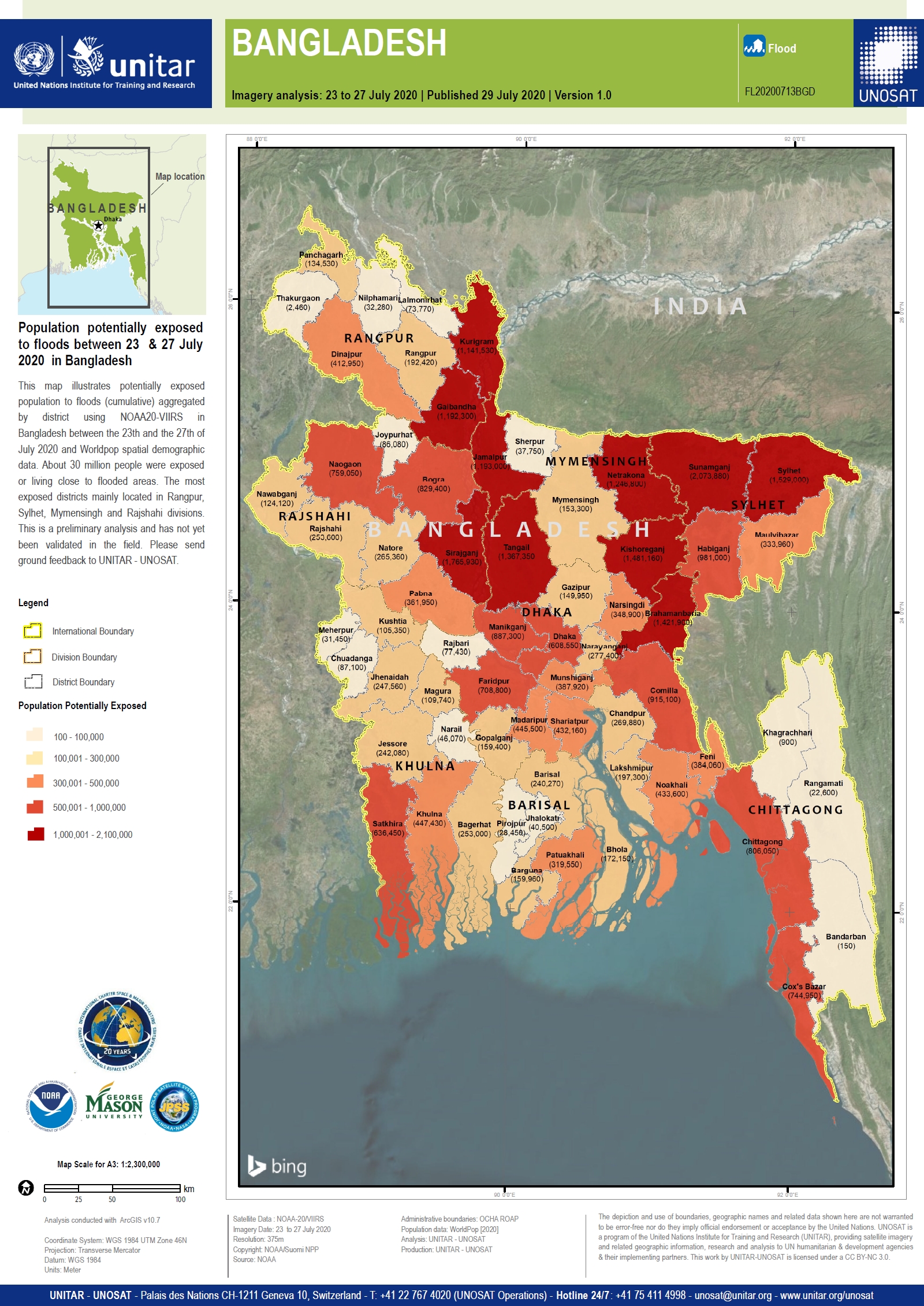
The heaviest rains in a decade have left a third of Bangladesh underwater affecting millions of people. The rains have swollen two main Himalayan river systems - the Brahmaputra and the Ganges - that flow through India and Bangladesh.
The Brahmaputra river is almost 40cm higher than normal and threatening to burst its banks in a number of locations. 15,000 people have already evacuated from flooded areas, and if rivers continue to swell the number of evacuations would increase dramatically.
Weather forecasts for the next 10 days are for further heavy rain. Officials in Bangladesh expecting the situation to worsen, as Covid-19 and weather conditions affect relief efforts.
| Local do evento: | Bangladesh |
| Data da Ativação da Carta: | 2020-07-13 |
| Tempo de Ativação da Carta: | 15:24 |
| Zona de Tempo da Ativação da Carta: | UTC+02:00 |
| Requisitante da Carta: | UNITAR on behalf of United Nations Office for the Coordination of Humanitarian Affairs (OCHA) |
| ID da Ativação: | 660 |
| Gerenciamento de projeto: | UNITAR/UNOSAT |
Products
Preliminary satellite-derived flood assessment Rangpur and Mymensingh divisions, Bangladesh
Download full report
Direitos autorais: © (2020) DigitalGlobe, Inc., Longmont CO USA 80503. DigitalGlobe and the DigitalGlobe logos are trademarks of DigitalGlobe, Inc. The use and/or dissemination of this data and/or of any product in any way derived there from are restricted. Unauthorized use and/or dissemination is prohibited
Report produced by UNITAR/UNOSAT
Information about the Product
Adquirida: 03/08/2020
Fonte: WorldView-2


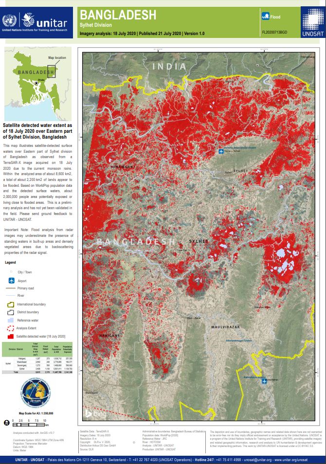

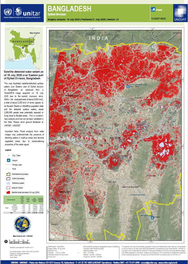

Satellite detected water extent as of 18 July 2020 over Mymensingh, Rajshahi and Rangpur Divisions, Bangladesh
Direitos autorais: Contains modified Copernicus Sentinel data (2020)
© DLR e.V. (2020), Distribution Airbus DS Geo GmbH
Information about the Product
Adquirida: Sentinel-1A: 13/07/2020
TANDEM-X: 18/07/2020
Fonte: SENTINEL-1A / TANDEM_X
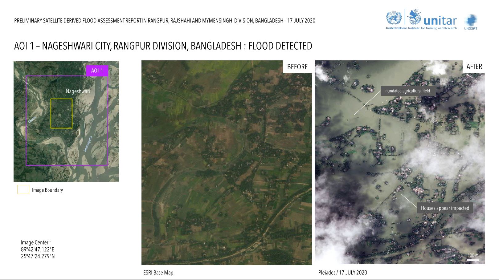
Preliminary Satellite Derived Flood Assessment in Rangpur, Rajshahi and Mymensingh Divisions, Bangladesh
Download the full report
Direitos autorais: Includes Pleiades material © CNES (2020), Distribution Airbus DS.
report prepared by UNOSAT
Information about the Product
Adquirida: PLEIADES_1A: 17/07/2020
Fonte: PLEIADES_1A

 Voltar ao arquivo completo da Ativação

