 English
 Spanish
 French
 Chinese
 Russian
 Portuguese
 Latest Activation
Charter activations
Flooding in Brazil
Heavy rainfall in Brazil has caused flooding in Acre State, affecting almost 40,000 people.
The flooding started on 25 February, and now affects 17 of the state's 22 municipalities. Days of torrential rain have caused water levels to rise to record levels in some areas, with the Acre River reaching 15.56 m. Other rivers affected include the Purus, Tarauacá, and Juruá, which are causing floods in the cities of Rio Branco, Xapuri, Santa Rosa do Purus, Jordão, and Marechal Taumaturgo, among others.
75% of the municipality of Brasiléia is flooded, and the city of Brasiléia is unreachable by road. It is estimated that 80% of Jordão is affected by the Tarauacá River flooding. The floods have caused difficulty in delivering relief to affected areas, flooding roads and damaging bridges. Thousands of people lost power supplies, and some hospitals have also been flooded, causing further difficulty in emergency response. It is estimated that 18,000 people have been left homeless by the extensive flooding.
Forecasters expect the rain to continue into March, worsening the situation.
| Tipo de evento: | Flood |
| Local do evento: | Brazil |
| Data da Ativação da Carta: | 2024-02-29 |
| Tempo de Ativação da Carta: | 10:08 |
| Zona de Tempo da Ativação da Carta: | UTC-03:00 |
| Requisitante da Carta: | CENAD on behalf of CENAD |
| ID da Ativação: | 865 |
| Gerenciamento de projeto: | Pedro Youssef (CENAD) |
| act-value-adders: | Serviço Geológico Brasileiro - SGB Luis Henrique Marques da Rosa Buani (CENAD) Artur Matos (SGB - Serviço Geológico Brasileiro) NOAA VA (NOAA) SERTIT Rapid Mapping Service INPE |
Products


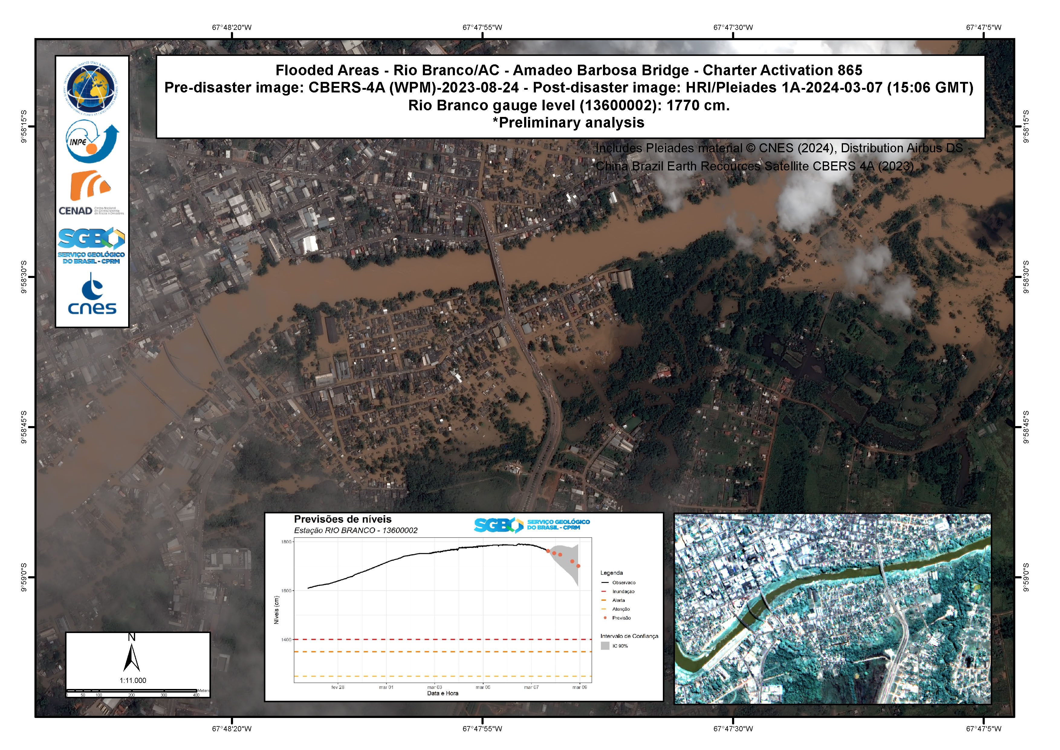
Before and After Comparison of Flooding in Rio Branco, Taquari and Ayrton Senna Localities, State of Acre, Brazil
Direitos autorais: CBERS-4 © INPE (2024)
Includes Pleiades material © CNES (2024), Distribution Airbus DS.
Map produced by Servicio Geológico do Brasil - CPRM.
Information about the Product
Adquirida: CBERS-4: 24/08/2023
Pleiades: 07/03/2024
Fonte: CBERS-4 and Pleiades
Categoria: Delineation Map

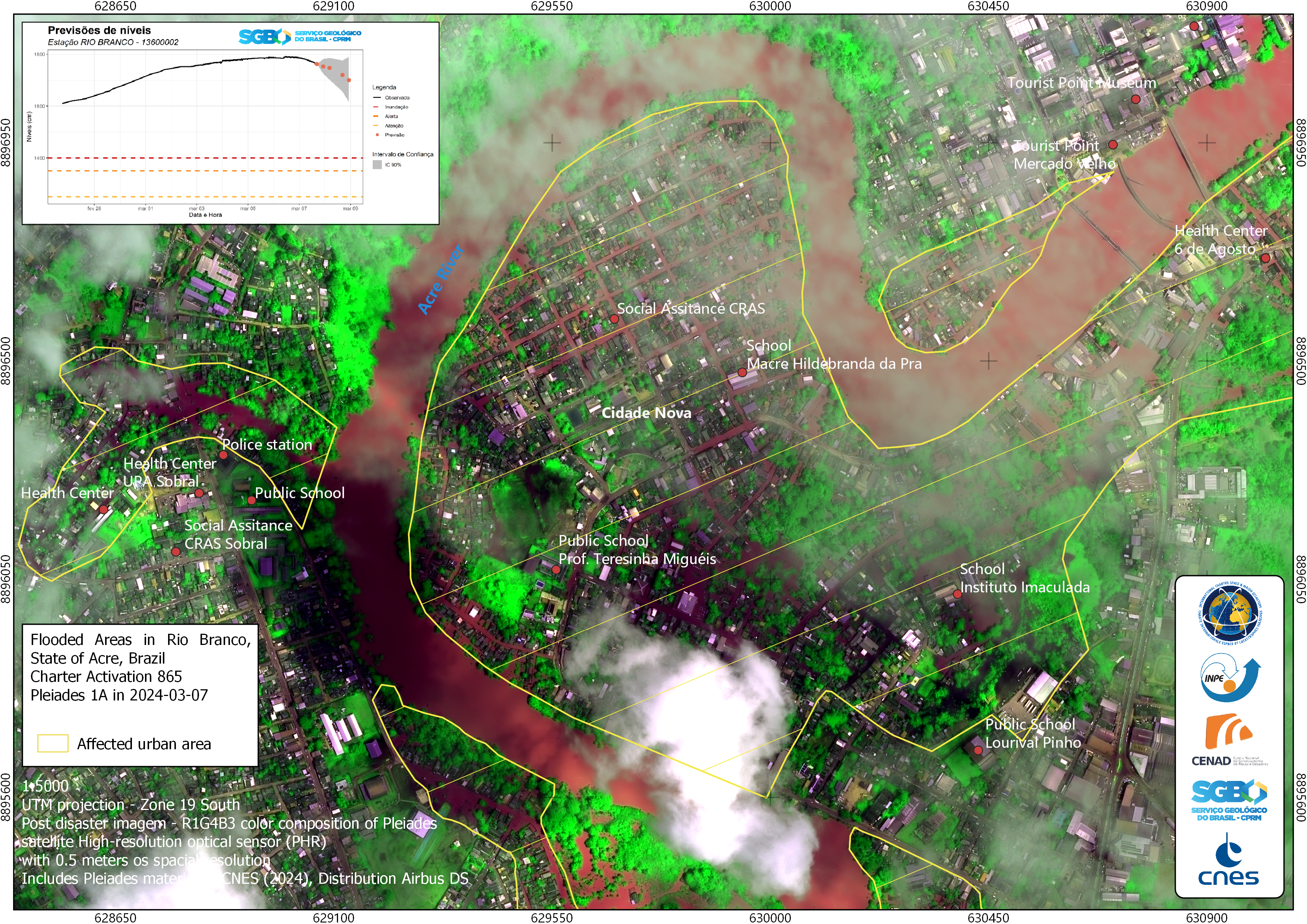
Before and after perspective of flooding in Rio Branco, Cidade Nova, State of Acre, Brazil
Direitos autorais: CBERS-4 © INPE (2024)
Includes Pleiades material © CNES (2024), Distribution Airbus DS.
Map produced by Servicio Geológico do Brasil - CPRM.
Information about the Product
Adquirida: CBERS-4: 24/08/2023
Pleiades: 07/03/2024
Fonte: CBERS-4 and Pleiades
Categoria: Delineation Map

Flooded Areas - Rio Branco/AC: 6 de Agosto neighborhood / Aeroporto Velho
Direitos autorais: Includes Pleiades material © CNES (2024), Distribution Airbus DS.
Map produced by Servicio Geológico do Brasil - CPRM.
Information about the Product
Adquirida: 07/03/2024
Fonte: Pleiades
Categoria: Delineation Map


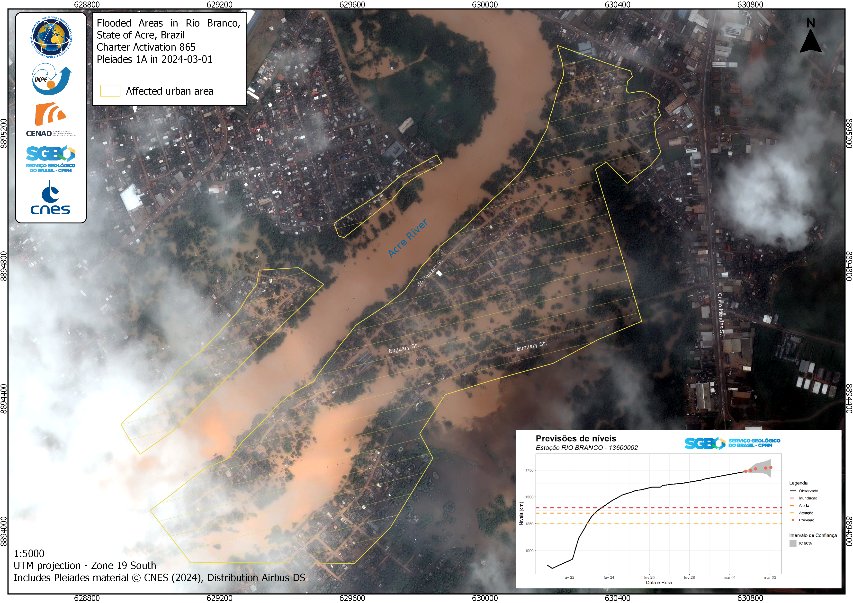
A Map showing the Before and After of Flooding in Rio Branco City Center in the State of Acre, Brazil
Direitos autorais: Includes Pleiades material © CNES (2024), Distribution Airbus DS.
Map produced by Servicio Geológico do Brasil - CPRM.
Information about the Product
Adquirida: PLEIADES_1A: 07/03/2024
Fonte: PLEIADES_1A
Categoria: Delineation Map


 Voltar ao arquivo completo da Ativação

