Minimizar Latest Activation

Charter activations

Earthquake, Tsunami in Southern Asia

A high-magnitude earthquake, 9.0 on the Richter scale, struck southern Asia at 00:58 UTC, 6:58 AM local time. The epicentre was 320 km west of Medan, just off the west coast of the Indonesian island of Sumatra. The earthquake was followed by tsunamis that killed nearly a quarter of a million people, mostly in Indonesia, Sri Lanka, and India. The coastal regions of India, Sri Lanka, Thailand, Indonesia, Maldives, Malaysia, and Myanmar were all severely affected. Bangladesh, the Seychelles, Somalia, Kenya, and Tanzania also suffered damage and loss of life.

Tipo de evento:Earthquake, tsunami
Local do evento:India; Sri Lanka, Thailand, Indonesia, Maldives, Malaysia, Myanmar (Burma)
Data da Ativação da Carta:26/12/2004
Requisitante da Carta:ISRO
Gerenciamento de projeto:ISRO, NRSA; UNOOSA, CNES

Products

Direitos autorais: Courtesy National Remote Sensing Agency, Govt. of India

Information about the Product

Fonte: IRS-P6 AWiFs imagery 18/12/2004-28/12/2004, before and after

Before and after tsunami satellite images, Little Nicobar Kola Auva Nicobar Islands

Direitos autorais: Courtesy National Remote Sensing Agency, Govt. of India

Information about the Product

Adquirida: 21/12/04, 31/12/04

Fonte: IRS-P6 AWiFS data, 21/12/04, and Radarsat SAR data, 31/12/04

Before and after tsunami satellite images, Nicobar

Direitos autorais: Courtesy National Remote Sensing Agency, Govt. of India

Information about the Product

Adquirida: 21/12/04, 26/12/04, 04/01/05

Fonte: IRS-P6 AWiFS data, 21/12/04, 26/12/04, and IRS-P6 LISS-III data, 04/01/05

Direitos autorais: Courtesy National Remote Sensing Agency, Govt. of India

Information about the Product

Fonte: IRS-P6 AWiFs imagery 18/12/2004-28/12/2004, before and after

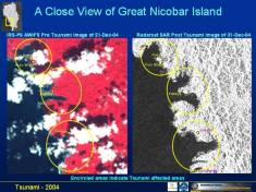
Before and after tsunami satellite images, Great Nicobar Nicobar Islands

Direitos autorais: Courtesy National Remote Sensing Agency, Govt. of India

Information about the Product

Adquirida: 21/12/04, 31/12/04

Fonte: IRS-P6 AWiFS data, 21/12/04, and Radarsat SAR data, 31/12/04

Before and after tsunami satellite images, Camorta

Direitos autorais: Courtesy National Remote Sensing Agency, Govt. of India

Information about the Product

Adquirida: 21/12/04, 26/12/04, 04/01/05

Fonte: IRS-P6 AWiFS data, 21/12/04, 26/12/04, and IRS-P6 LISS-III data, 04/01/05

Direitos autorais: Courtesy National Remote Sensing Agency, Govt. of India

Information about the Product

Fonte: IRS-P6 AWiFs imagery 18/12/2004-28/12/2004, before and after

Before and after tsunami satellite images, Great Nicobar Pulo Kunji Nicobar Islands

Direitos autorais: Courtesy National Remote Sensing Agency, Govt. of India

Information about the Product

Adquirida: 21/12/04, 31/12/04

Fonte: IRS-P6 AWiFS data, 21/12/04, and Radarsat SAR data, 31/12/04

Before and after tsunami satellite images, Camorta

Direitos autorais: Courtesy National Remote Sensing Agency, Govt. of India

Information about the Product

Adquirida: 21/12/04, 26/12/04, 04/01/05

Fonte: IRS-P6 AWiFS data, 21/12/04, 26/12/04, and IRS-P6 LISS-III data, 04/01/05

Post-tsunami satellite map, IRS Before After Tsunami Karaikal India

Direitos autorais: Map produced 02/01/2005 by UNOSAT

Information about the Product

Adquirida: 02/01/2005

Fonte: IRS-P6 AWiFS data

Direitos autorais: Courtesy National Remote Sensing Agency, Govt. of India

Information about the Product

Fonte: IRS-P6 AWiFs imagery 18/12/2004-27/12/2004, before and after

Before and after tsunami satellite images, Great Nicobar Kopenheat Nicobar Islands

Direitos autorais: Courtesy National Remote Sensing Agency, Govt. of India

Information about the Product

Adquirida: 21/12/04, 31/12/04

Fonte: IRS-P6 AWiFS data, 21/12/04, and Radarsat SAR data, 31/12/04

Before and after tsunami satellite images, Nancowry

Direitos autorais: Courtesy National Remote Sensing Agency, Govt. of India

Information about the Product

Adquirida: 21/12/04, 26/12/04, 04/01/05

Fonte: IRS-P6 AWiFS data, 21/12/04, 26/12/04, and IRS-P6 LISS-III data, 04/01/05

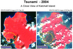
Before and after tsunami satellite images, Katchall

Direitos autorais: Courtesy National Remote Sensing Agency, Govt. of India

Information about the Product

Adquirida: 21/12/04, 26/12/04, 04/01/05

Fonte: IRS-P6 AWiFS data, 21/12/04, 26/12/04, and IRS-P6 LISS-III data, 04/01/05

Direitos autorais: Courtesy National Remote Sensing Agency, Govt. of India.

Information about the Product

Fonte: IRS-1D LISS-III imagery, 21/12/2004, IRS-1C LISS-III imagery, 30/12/2004, Car Nicobar Island

Regional Topographic map, with affected areas, population density and digital elevation model

Information about the Product

Fonte: UNJLC

Before and after tsunami satellite images, Male, Maldives

Direitos autorais: Courtesy National Remote Sensing Agency, Govt. of India

Information about the Product

Adquirida: 03/01/05

Fonte: IRS-P6 LISS-IV MX data, 09/02/04, IRS 1D PAN, 03/01/05

Before and after tsunami satellite images, Pumpukar Surroundings Tamil Nadu

Direitos autorais: Courtesy National Remote Sensing Agency, Govt. of India

Information about the Product

Adquirida: 01/01/05

Fonte: Envisat SAR data, 29/12/04 and 01/01/05

Direitos autorais: Courtesy National Remote Sensing Agency, Govt. of India.

Information about the Product

Fonte: IRS-1D LISS-III imagery, 21/12/2004, IRS-1C LISS-III imagery, 30/12/2004, Car Nicobar Island

Regional Topographic map, with affected areas, population density and digital elevation model.

Information about the Product

Fonte: UNJLC

Before and after tsunami satellite images, Huhule, Maldives

Direitos autorais: Courtesy National Remote Sensing Agency, Govt. of India

Information about the Product

Adquirida: 03/01/05

Fonte: IRS-P6 LISS-IV MX data, 09/02/04, IRS 1D PAN, 03/01/05

Before and after tsunami satellite images, Great Nicobar Patitiya Nicobar Islands

Direitos autorais: Courtesy National Remote Sensing Agency, Govt. of India

Information about the Product

Adquirida: 21/12/04, 31/12/04

Fonte: IRS-P6 AWiFS data, 21/12/04, and Radarsat SAR data, 31/12/04

Direitos autorais: Courtesy National Remote Sensing Agency, Govt. of India.

Information about the Product

Fonte: IRS-1D LISS-III imagery, 21/12/2004, IRS-1C LISS-III imagery, 30/12/2004, Car Nicobar Island

Topographic map of Sumatra, with affected areas, population density and digital elevation model.

Information about the Product

Fonte: UNJLC.

Before and after tsunami satellite images, Tamil Nadu Coast Tamil Nadu

Direitos autorais: Courtesy National Remote Sensing Agency, Govt. of India

Information about the Product

Adquirida: 29/12/04

Fonte: IRS-P6 LISS-III data, 15/08/04 and Envisat SAR data, 29/12/04

Before and after tsunami satellite images, Great Nicobar Pulobaha Nicobar Islands

Direitos autorais: Courtesy National Remote Sensing Agency, Govt. of India

Information about the Product

Adquirida: 21/12/04, 31/12/04

Fonte: IRS-P6 AWiFS data, 21/12/04, and Radarsat SAR data, 31/12/04

Direitos autorais: Courtesy National Remote Sensing Agency, Govt. of India

Information about the Product

Fonte: IRS-P4 OCM, IRS-P6 AWiFs imagery 26/12/2004

Carte topographique régionale, montrant des zones touchées, densité de la population et modèle numérique du terrain.

Information about the Product

Fonte: Centre de logistique des Nations Unies.

Potential land affected by Tsunami over the whole area.

Direitos autorais: European Commission, Joint Research Institute. Regional land cover map generated by a partnership coordinated by JRC, part of Global Land Cover 2000 project.

Before and after tsunami satellite images, Pondicherry Tamil Nadu

Direitos autorais: Courtesy National Remote Sensing Agency, Govt. of India

Information about the Product

Adquirida: 29/12/04

Fonte: IRS-P6 LISS-III data, 15/08/04 and Envisat SAR data, 29/12/04

Post-tsunami satellite map, IRS Before After Tsunami Agasympalli India

Direitos autorais: Map produced 02/01/2005 by UNOSAT

Information about the Product

Adquirida: 02/01/2005

Fonte: IRS-P6 AWiFS data

Direitos autorais: Courtesy National Remote Sensing Agency, Govt. of India.

Information about the Product

Fonte: IRS-1D LISS-III imagery, 21/12/2004, IRS-1C LISS-III imagery, 30/12/2004, Car Nicobar Island

Before and after tsunami satellite images, Cuddalore Tamil Nadu

Direitos autorais: Courtesy National Remote Sensing Agency, Govt. of India

Information about the Product

Adquirida: 29/12/04

Fonte: IRS-P6 LISS-III data, 15/08/04 and Envisat SAR data, 29/12/04

Post-tsunami satellite map, IRS Before After Tsunami Chennai Indiar

Direitos autorais: Map produced 02/01/2005 by UNOSAT

Information about the Product

Adquirida: 02/01/2005

Fonte: IRS-P6 AWiFS data

Direitos autorais: Courtesy National Remote Sensing Agency, Govt. of India.

Information about the Product

Fonte: IRS-1D LISS-III imagery, 21/12/2004, IRS-1C LISS-III imagery, 30/12/2004, Car Nicobar Island

Before and after tsunami satellite images, Tarangambadi Surroundings Tamil Nadu

Direitos autorais: Courtesy National Remote Sensing Agency, Govt. of India

Information about the Product

Adquirida: 01/01/05

Fonte: Envisat SAR data, 29/12/04 and 01/01/05

Before and after tsunami satellite images, Tirumullaivasal Tamil Nadu

Direitos autorais: Courtesy National Remote Sensing Agency, Govt. of India

Information about the Product

Adquirida: 29/12/04

Fonte: IRS-P6 LISS-III data, 15/08/04 and Envisat SAR data, 29/12/04

Post-tsunami satellite map, IRS Before After Tsunami North Camorta Nicobar

Direitos autorais: Map produced 02/01/2005 by UNOSAT

Information about the Product

Adquirida: 02/01/2005

Fonte: IRS-P6 AWiFS data

Direitos autorais: Courtesy National Remote Sensing Agency, Govt. of India

Information about the Product

Fonte: IRS-P6 AWiFs imagery 21/12/2004-26/12/2004, before and after tsunami

Potential population affected by Tsunami over the whole area.

Direitos autorais: Population density data from Landscan 2002 Elevation data from SRTM (NASA)

Information about the Product

Fonte: European Commission, Joint Research Institute.

Before and after tsunami satellite images, Pumpukar Tamil Nadu

Direitos autorais: Courtesy National Remote Sensing Agency, Govt. of India

Information about the Product

Adquirida: 29/12/04

Fonte: IRS-P6 LISS-III data, 15/08/04 and Envisat SAR data, 29/12/04

Post-tsunami satellite map, IRS Before After Tsunami North Center Nicobar

Direitos autorais: Map produced 02/01/2005 by UNOSAT

Information about the Product

Adquirida: 02/01/2005

Fonte: IRS-P6 AWiFS data

Direitos autorais: Courtesy National Remote Sensing Agency, Govt. of India.

Information about the Product

Fonte: IRS-P6 AWiFs imagery 21/12/2004-26/12/2004, before and after tsunami

Before and after tsunami satellite images, Tarangambadi Tamil Nadu

Direitos autorais: Courtesy National Remote Sensing Agency, Govt. of India

Information about the Product

Adquirida: 29/12/04

Fonte: IRS-P6 LISS-III data, 15/08/04 and Envisat SAR data, 29/12/04

Post-tsunami satellite map, IRS Before After Tsunami North Katchall Nicobar

Direitos autorais: Map produced 02/01/2005 by UNOSAT

Information about the Product

Adquirida: 02/01/2005

Fonte: IRS-P6 AWiFS data

Direitos autorais: Courtesy National Remote Sensing Agency, Govt. of India

Information about the Product

Fonte: IRS-P6 AWiFs imagery 21/12/2004-26/12/2004, before and after tsunami

Before and after tsunami satellite images, Karaikal Tamil Nadu

Direitos autorais: Courtesy National Remote Sensing Agency, Govt. of India

Information about the Product

Adquirida: 29/12/04

Fonte: IRS-P6 LISS-III data, 15/08/04 and Envisat SAR data, 29/12/04

Post-tsunami satellite map, IRS Before After Tsunami Trinkat Nicobar

Direitos autorais: Map produced 02/01/2005 by UNOSAT

Information about the Product

Adquirida: 02/01/2005

Fonte: IRS-P6 AWiFS data

Direitos autorais: Courtesy National Remote Sensing Agency, Govt. of India

Information about the Product

Fonte: IRS-P6 AWiFs imagery 21/12/2004-26/12/2004, before and after tsunami

Regional map of countries most affected by the Tsunami. Show zones under 30 meters elevation.

Information about the Product

Fonte: UNOSAT, USGS, NASA (SRTM30/ETOPO2/MODIS), Global Insight.

Before and after tsunami satellite images, Nagappattinam Tamil Nadu

Direitos autorais: Courtesy National Remote Sensing Agency, Govt. of India

Information about the Product

Adquirida: 29/12/04

Fonte: IRS-P6 LISS-III data, 15/08/04 and Envisat SAR data, 29/12/04

Post-tsunami satellite map, Malacca Nicobar

Direitos autorais: Map produced 01/01/2005 by UNOSAT

Information about the Product

Adquirida: 01/01/2005

Fonte: Landsat ETM, 08/08/1999 and SPOT 5 data, 2.5 m resolution, 29/12/2004

Direitos autorais: Courtesy National Remote Sensing Agency, Govt. of India

Information about the Product

Fonte: IRS-P6 AWiFs imagery 21/12/2004-26/12/2004, before and after tsunami

Before and after tsunami satellite images, Nagappattinam Surroundings Tamil Nadu

Direitos autorais: Courtesy National Remote Sensing Agency, Govt. of India

Information about the Product

Adquirida: 29/12/04

Fonte: IRS-P6 LISS-III data, 15/08/04 and merged image IRS LISS-III, 15/08/04 and Envisat SAR data, 29/12/04
Post-tsunami satellite map, Maldives Dhigafinolhu

Direitos autorais: Map produced 31/12/2004 by UNOSAT

Information about the Product

Adquirida: 31/12/2004

Fonte: SPOT 5 data, 2.5 m resolution.

Direitos autorais: Courtesy National Remote Sensing Agency, Govt. of India

Information about the Product

Fonte: IRS-P6 L4 MX imagery 12/01/2004-27/12/2004, before and after tsunami

Before and after tsunami satellite images, Vedaranniyam Tamil Nadu

Direitos autorais: Courtesy National Remote Sensing Agency, Govt. of India

Information about the Product

Adquirida: 29/12/04

Fonte: IRS-P6 LISS-III data, 15/08/04 and Envisat SAR data, 29/12/04

Post-tsunami satellite map, Maldives Gulhi

Direitos autorais: Map produced 31/12/2004 by UNOSAT

Information about the Product

Adquirida: 31/12/2004

Fonte: SPOT 5 data, 2.5 m resolution.

Direitos autorais: Courtesy National Remote Sensing Agency, Govt. of India

Information about the Product

Fonte: IRS-P6 L4 MX imagery 12/01/2004-27/12/2004, before and after tsunami

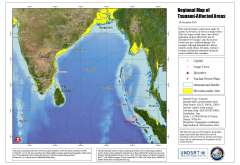
Regional map of tsunami-affected areas, scale: 1:12,000,000

Elevation data: SRTM (3 arc seconds). Shows coastal areas under 20 meters elevation. Map produced 28/12/2004 by UNOSAT.

Information about the Product

Fonte: GLCF, NASA, USGS. MODIS-Terra Mosaic SRTM (3 arc seconds). Shows coastal areas under 20 meters elevation. Map produced 28/12/2004 by UNOSAT.

Before and after tsunami satellite images, Vedaranniyam Surroundings Tamil Nadu

Direitos autorais: Courtesy National Remote Sensing Agency, Govt. of India

Information about the Product

Adquirida: 29/12/04

Fonte: IRS-P6 LISS-III data, 15/08/04 and Envisat SAR data, 29/12/04

Post-tsunami satellite map, Maldives Guralahu

Direitos autorais: Map produced 31/12/2004 by UNOSAT

Information about the Product

Adquirida: 31/12/2004

Fonte: SPOT 5 data, 2.5 m resolution.

Before and after tsunami satellite images, Pumpukar Surroundings Tamil Nadu

Direitos autorais: Courtesy National Remote Sensing Agency, Govt. of India

Information about the Product

Adquirida: 01/01/05

Fonte: Envisat SAR data, 29/12/04 and 01/01/05

Post-tsunami satellite map, Maldives Mafushi

Direitos autorais: Map produced 31/12/2004 by UNOSAT

Information about the Product

Adquirida: 31/12/2004

Fonte: SPOT 5 data, 2.5 m resolution.

Direitos autorais: Courtesy National Remote Sensing Agency, Govt. of India

Information about the Product

Fonte: IRS-P6 L4 MX imagery 12/01/2004-27/12/2004, before and after tsunami

Before and after tsunami satellite images, Karaikal Surroundings Tamil Nadu

Direitos autorais: Courtesy National Remote Sensing Agency, Govt. of India

Information about the Product

Adquirida: 01/01/05

Fonte: Envisat SAR data, 29/12/04 and 01/01/05

Before and after tsunami satellite images, Kerala

Direitos autorais: Courtesy National Remote Sensing Agency, Govt. of India

Information about the Product

Adquirida: 27/12/04

Fonte: IRS-1D LISS data, 19/12/04 and 27/12/04

Direitos autorais: Courtesy National Remote Sensing Agency, Govt. of India.

Information about the Product

Fonte: IRS-1D LISS-III imagery, 21/12/2004, IRS-1C LISS-III imagery, 30/12/2004, Car Nicobar Island

Before and after tsunami satellite images, Nagappattinam Surroundings Tamil Nadu

Direitos autorais: Courtesy National Remote Sensing Agency, Govt. of India

Information about the Product

Adquirida: 01/01/05

Fonte: Envisat SAR data, 29/12/04 and 01/01/05

Before and after tsunami satellite images, Tottapalli, Kerala

Direitos autorais: Courtesy National Remote Sensing Agency, Govt. of India

Information about the Product

Adquirida: 27/12/04

Fonte: IRS-1D LISS data, 19/12/04 and 27/12/04

Direitos autorais: Courtesy National Remote Sensing Agency, Govt. of India.

Information about the Product

Fonte: IRS-1D LISS-III imagery, 21/12/2004, IRS-1C LISS-III imagery, 30/12/2004, Car Nicobar Island

Before and after tsunami satellite images, Nagappattinam Surroundings Tamil Nadu

Direitos autorais: Courtesy National Remote Sensing Agency, Govt. of India

Information about the Product

Adquirida: 01/01/05

Fonte: Envisat SAR data, 29/12/04 and 01/01/05

Before and after tsunami satellite images, Paravur, Kerala

Direitos autorais: Courtesy National Remote Sensing Agency, Govt. of India

Information about the Product

Adquirida: 27/12/04

Fonte: IRS-1D LISS data, 19/12/04 and 27/12/04

Direitos autorais: Courtesy National Remote Sensing Agency, Govt. of India

Information about the Product

Fonte: IRS-P6 L4 MX imagery 12/01/2004-27/12/2004, before and after tsunami

Before and after tsunami satellite images, View Of Nicobar Islands

Direitos autorais: Courtesy National Remote Sensing Agency, Govt. of India

Information about the Product

Adquirida: 21/12/04, 26/12/04, 31/12/04

Fonte: IRS-P6 AWiFS data, 21/12/04, 26/12/04, and Radarsat SAR data, 31/12/04

Before and after tsunami satellite images, Chirayinkil, Kerala

Direitos autorais: Courtesy National Remote Sensing Agency, Govt. of India

Information about the Product

Adquirida: 27/12/04

Fonte: IRS-1D LISS data, 19/12/04 and 27/12/04

Direitos autorais: Courtesy National Remote Sensing Agency, Govt. of India

Information about the Product

Fonte: IRS-P6 AWiFs imagery 18/12/2004

Before and after tsunami satellite images, Little Nicobar Pulo Milo Nicobar Islands

Direitos autorais: Courtesy National Remote Sensing Agency, Govt. of India

Information about the Product

Adquirida: 21/12/04, 31/12/04

Fonte: IRS-P6 AWiFS data, 21/12/04, and Radarsat SAR data, 31/12/04

Before and after tsunami satellite images, Trinkat

Direitos autorais: Courtesy National Remote Sensing Agency, Govt. of India

Information about the Product

Adquirida: 21/12/04, 26/12/04, 04/01/05

Fonte: IRS-P6 AWiFS data, 21/12/04, 26/12/04, and IRS-P6 LISS-III data, 04/01/05

Voltar ao arquivo completo da Ativação