 English
 Spanish
 French
 Chinese
 Russian
 Portuguese
 Latest Activation
Charter activations
Earthquake in Mexico
A powerful 7.1 magnitude earthquake struck central Mexico on 19 September. The epicentre of the powerful earthquake was approximately 3 miles east-northeast of San Juan Raboso and 34 miles south-southwest of the city of Puebla, and 75 miles from Mexico City.
The capital city was particularly affected by the earthquake, where almost half of the casualties took place. Many people were trapped under collapsed buildings and rescuers have spent days searching for survivors. The President reported that several children were killed and many more went missing as a result of a school collapse.
Emergency workers, military personnel, and volunteers are searching through rubble to recover survivors. Over 2 million people in the capital were left without electricity and phone lines.
In addition to Mexico City, the states of Morelos, Puebla, Guerrero and Oaxaca have also been affected and a second 6.1 magnitude earthquake occurred in Oaxaca on 23 September, further disrupting rescue operations.
Earlier in September an 8.1 magnitude earthquake struck off the southern coast of Mexico, killing 90 people, but it is believed that there is no connection between these two earthquakes.
| Tipo de evento: | Earthquake |
| Local do evento: | Mexico |
| Data da Ativação da Carta: | 2017-09-20 |
| Tempo de Ativação da Carta: | 03:00 |
| Zona de Tempo da Ativação da Carta: | UTC+02:00 |
| Requisitante da Carta: | UNITAR-UNOSAT on behalf of UNOCHA |
| ID da Ativação: | 555 |
| Gerenciamento de projeto: | UNITAR / UNOSAT |
Products

Damage assessment of Cuautepec Madero
Direitos autorais: WorldView-2 © DigitalGlobe Inc.
Map produced by Autonomous University of the State of Mexico
Information about the Product
Adquirida: 26/09/2017
Fonte: WorldView-2
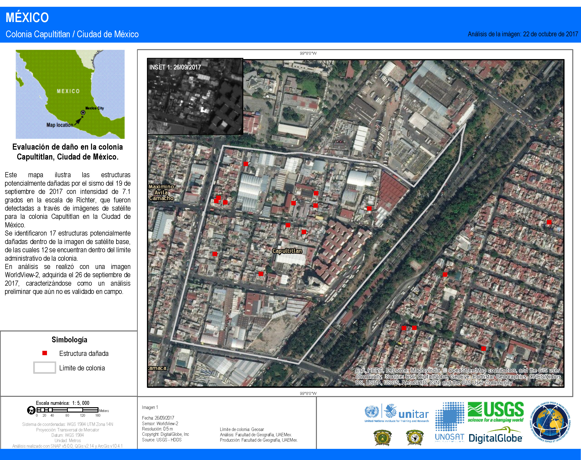
Damage assessment of Capultitlan
Direitos autorais: WorldView-2 © DigitalGlobe Inc.
Map produced by Autonomous University of the State of Mexico
Information about the Product
Adquirida: 26/09/2017
Fonte: WorldView-2
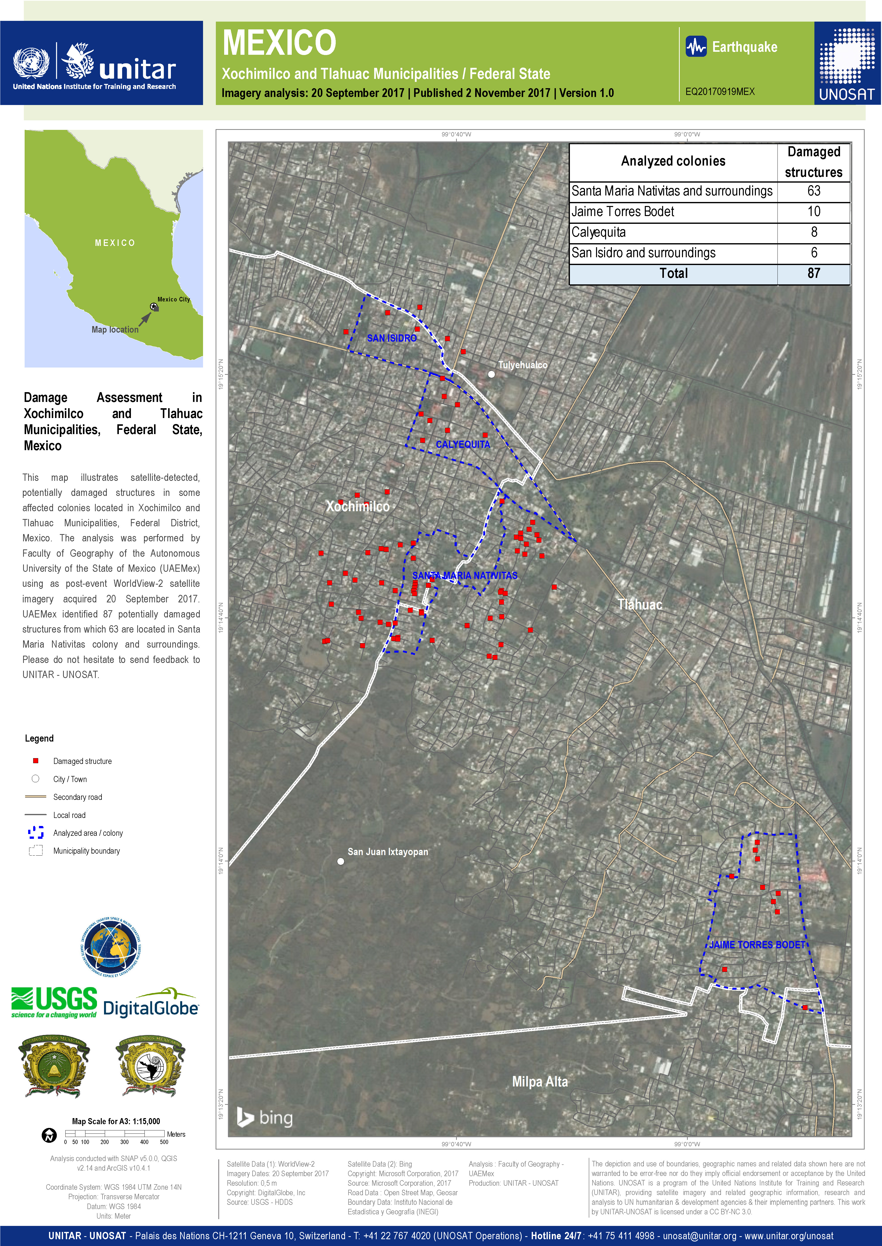
Damage assessment of Xochimilco and Tlahua Municipalities
Direitos autorais: WorldView-2 © DigitalGlobe Inc.
Map produced by UNITAR/UNOSAT based on results provided by the Autonomous University of the State of Mexico
Information about the Product
Adquirida: 20/09/2017
Fonte: WorldView-2
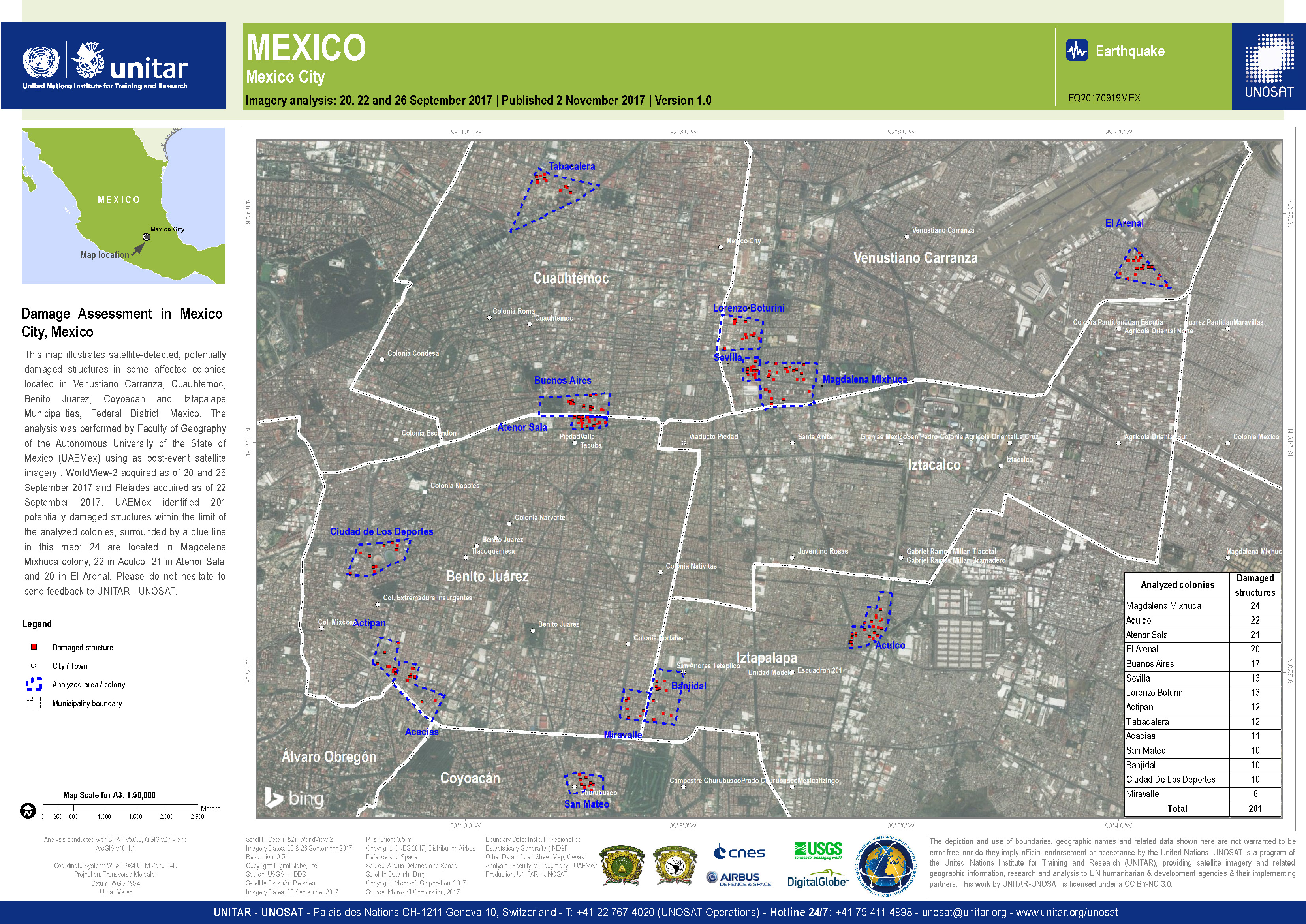
Damage assessment of Mexico City
Direitos autorais: WorldView-2 © DigitalGlobe Inc.
Pleiades © CNES (2017) - Distribution: Airbus Defence and Space, all rights reserved
Map produced by UNITAR/UNOSAT based on results provided by the Autonomous University of the State of Mexico
Information about the Product
Adquirida: WorldView-2: 20/09/2017 and 26/09/2017
Pleiades: 22/09/2017
Fonte: WorldView-2 / Pleiades
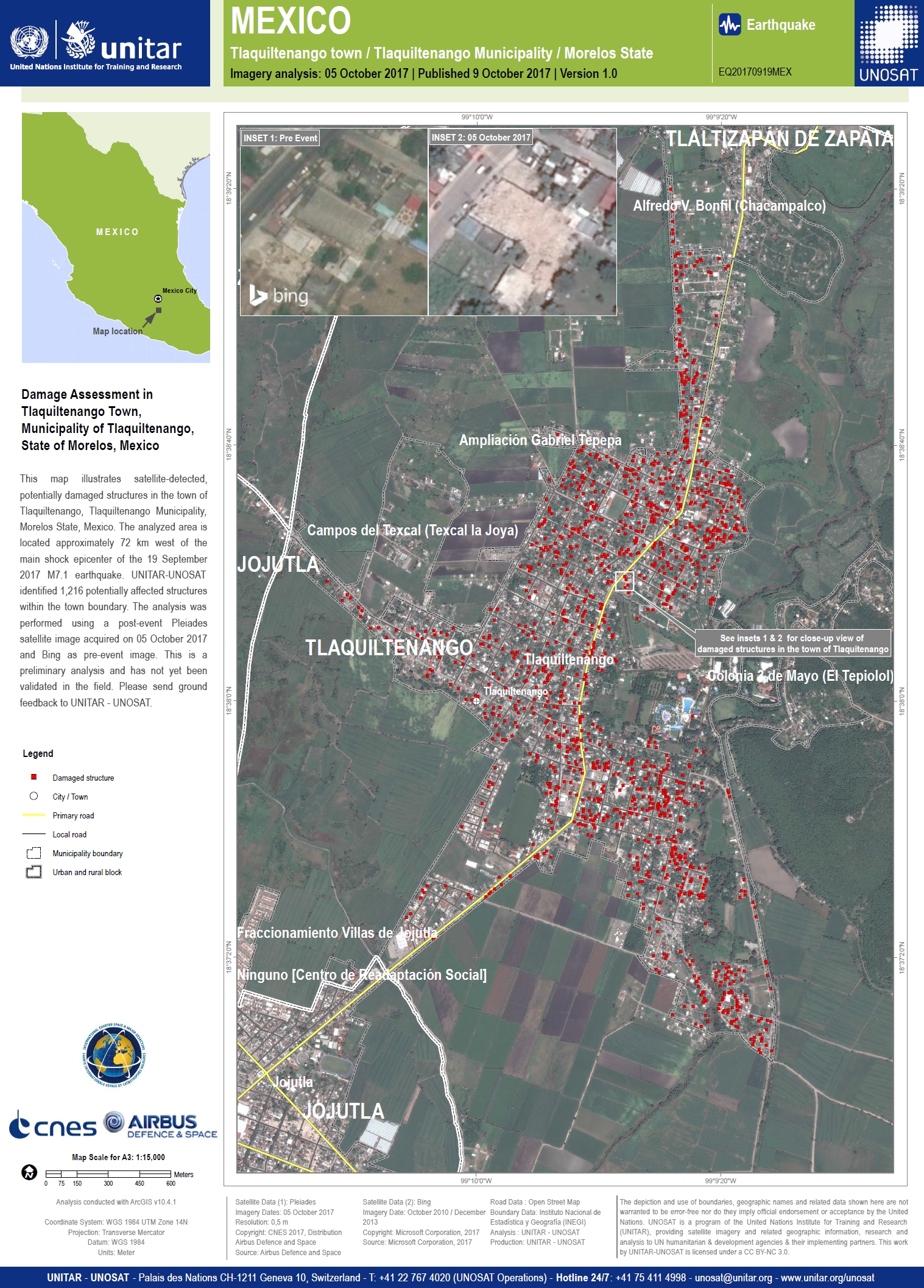
Damage Assessment in Tlaquiltenango Town, State of Morelos
Direitos autorais: Pleiades © CNES (2017) - Distribution: Airbus Defence and Space, all rights reserved
Map produced by UNITAR / UNOSAT
Information about the Product
Adquirida: 05/10/2017
Fonte: Pleiades
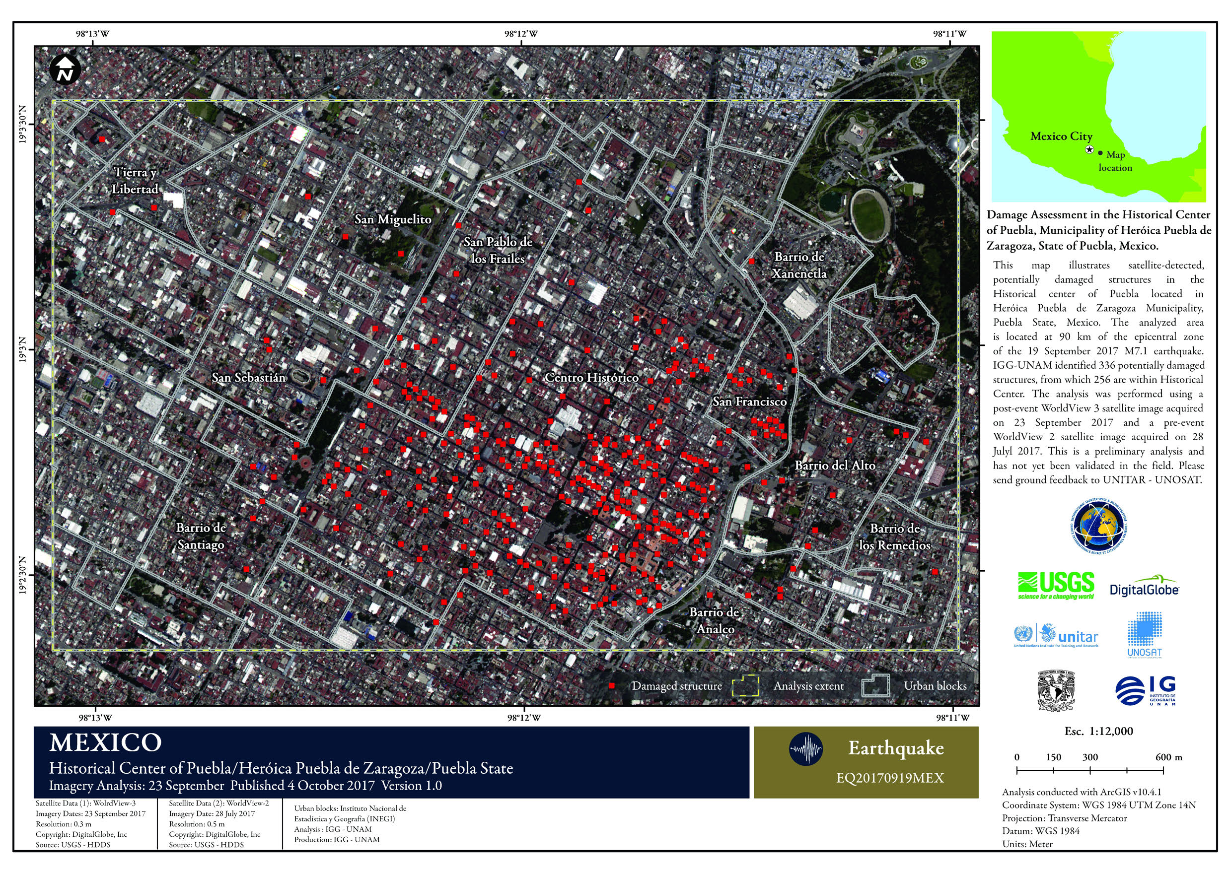
Damage assessment of the Historical Center of Puebla
Direitos autorais: WorldView-3 and 2 © DigitalGlobe Inc.
Map produced by IGG-UNAM
Information about the Product
Adquirida: WorldView-3: 23/09/2017
WorldView-2: 28/07/2017
Fonte: WorldView-3 / WorldView-2

Damage assessment in the south west of Cuauhtemoc Municipality, Federal District
Direitos autorais: WorldView-2 © DigitalGlobe Inc
Map produced by UNITAR/UNOSAT
Information about the Product
Adquirida: 26/09/2017
Fonte: WorldView-2

Damage assessment in Jojutla town, State of Morelos
Direitos autorais: Pleiades © CNES (2017) - Distribution: Airbus Defence and Space, all rights reserved
Map produced by UNITAR / UNOSAT
Information about the Product
Adquirida: 03/10/2017
Fonte: Pleiades
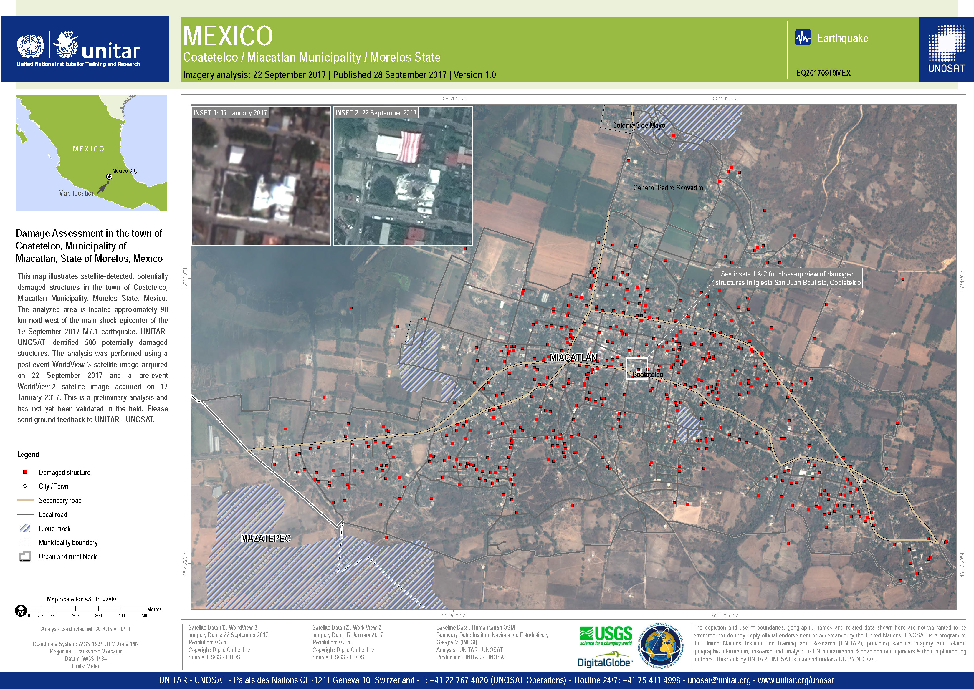
Damage assessment of Coatetelco in Morelos State
Direitos autorais: WorldView-3 and 2 © DigitalGlobe Inc.
Map produced by UNITAR/UNOSAT
Information about the Product
Adquirida: Pre-disaster: 17/01/2017
Post-disaster: 22/09/2017
Fonte: WorldView-3 / WorldView-2

Damage assessment in the Central West Cuernavaca City, Municipality of Cuernavaca, State of Morelos
Direitos autorais: WorldView-3 and 2 © DigitalGlobe Inc.
Map produced by UNITAR/UNOSAT
Information about the Product
Adquirida: Pre-disaster: 13/02/2017
Post-disaster: 22/09/2017
Fonte: WorldView-3 / WorldView-2
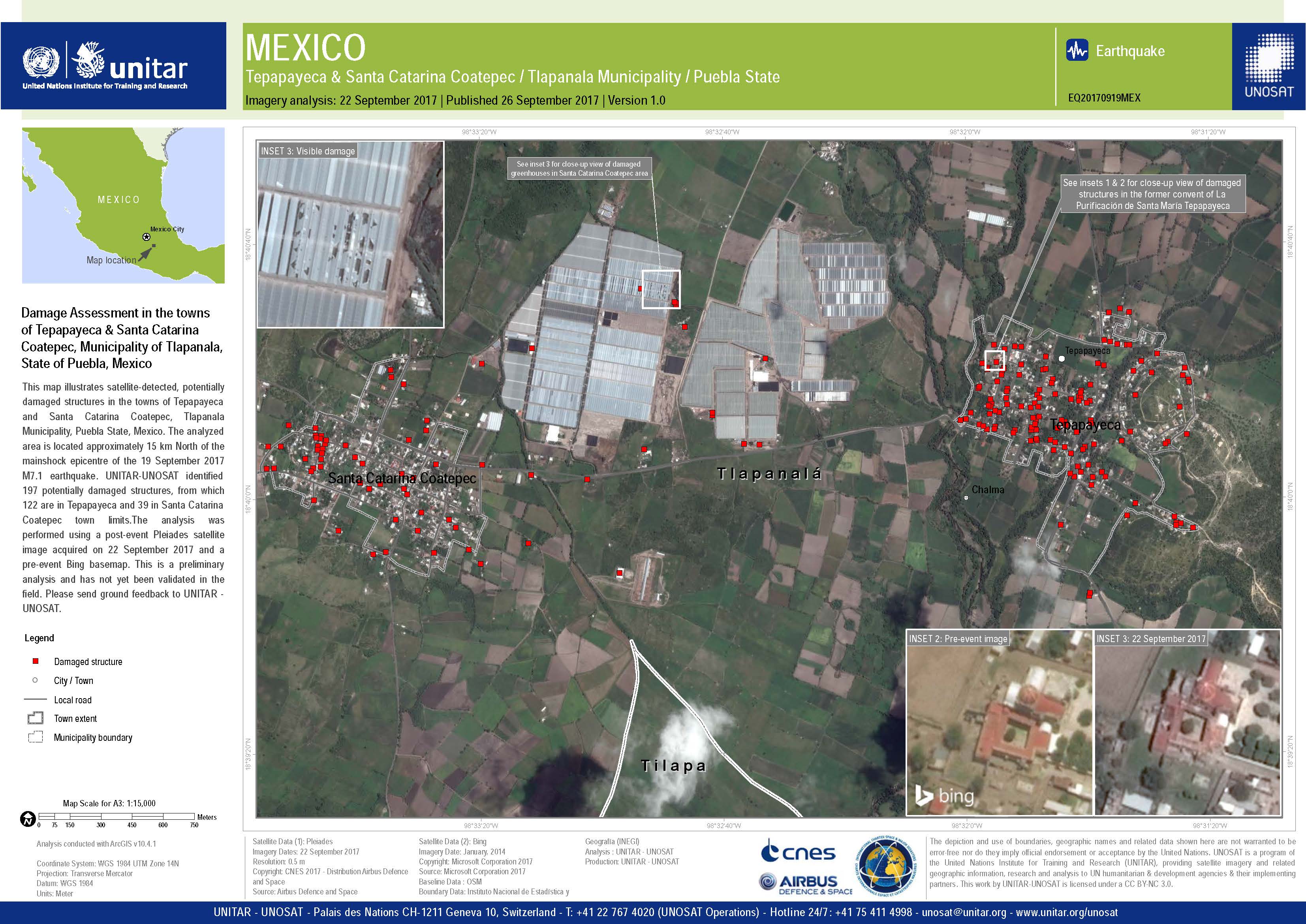
Damage assessment in the towns of Tepapayeca & Santa Catarina Coatepec, Municipality of Tlapanala, State of Puebla
Direitos autorais: Pleiades © CNES (2017) - Distribution: Airbus Defence and Space, all rights reserved
Map produced by UNITAR/UNOSAT
Information about the Product
Adquirida: 22/09/2017
Fonte: Pleiades

Damage assessment of La Galarza, in Puebla State
Direitos autorais: Pleiades © CNES (2017) - Distribution: Airbus Defence and Space, all rights reserved
Map produced by UNITAR/UNOSAT
Information about the Product
Adquirida: 22/09/2017
Fonte: Pleiades

Damage assessment of Ayutla and San Nicolas Tolentino, in Puebla State
Direitos autorais: Pleiades © CNES (2017) - Distribution: Airbus Defence and Space, all rights reserved
WorldView-2 © DigitalGlobe Inc.
Map produced by UNITAR/UNOSAT
Information about the Product
Adquirida: Pleiades: 22/09/2017
WorldView-2: 11/04/2017
Fonte: Pleiades / WorldView-2

Damage assessment of Atzala, in Puebla State
Direitos autorais: Pleiades © CNES (2017) - Distribution: Airbus Defence and Space, all rights reserved
WorldView-2 © DigitalGlobe Inc.
Map produced by UNITAR/UNOSAT
Information about the Product
Adquirida: Pleiades: 23/09/2017
WorldView-2: 11/04/2017
Fonte: Pleiades / WorldView-2
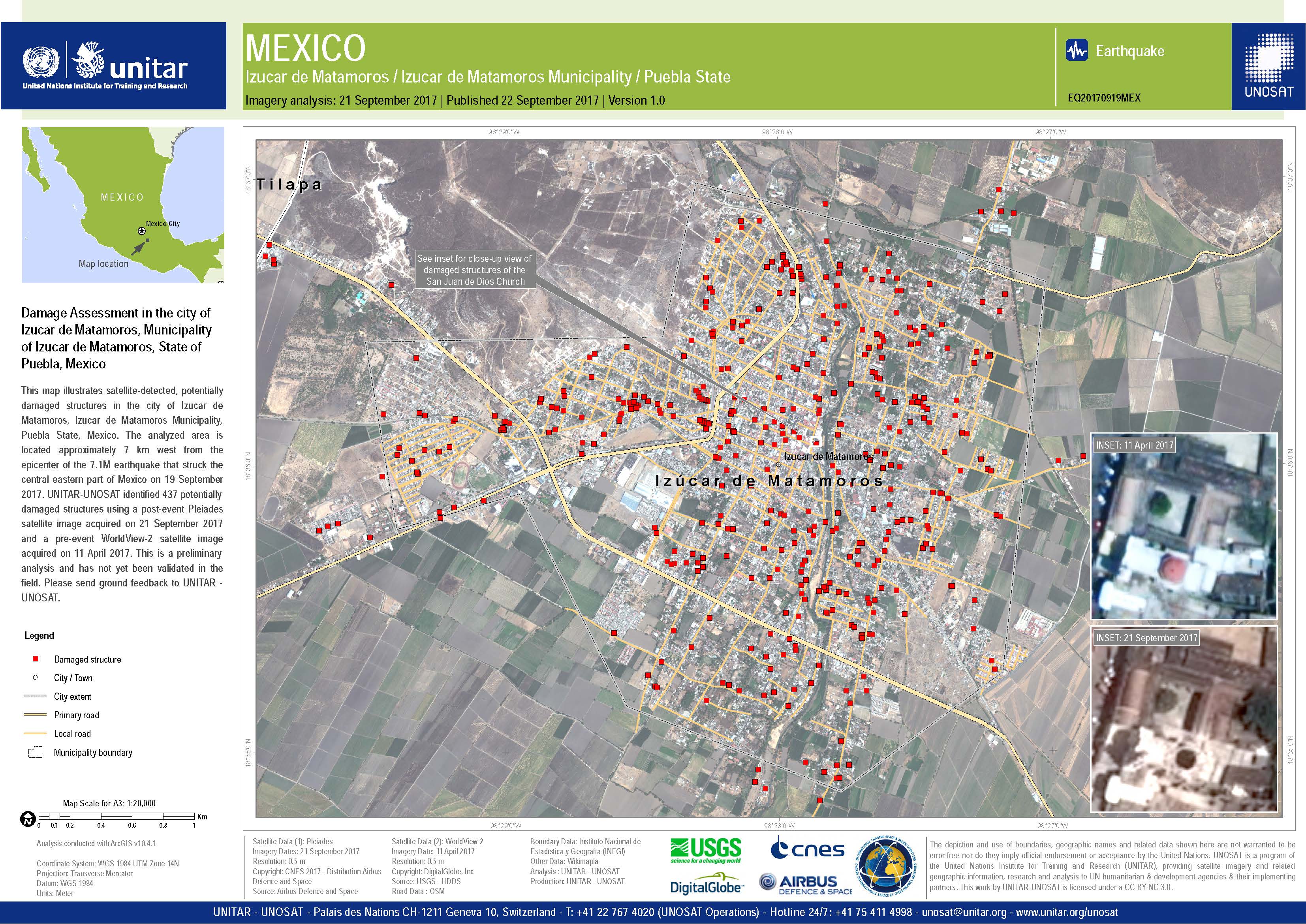
Damage Assessment in the city of Izucar de Matamoros, in Puebla State
Direitos autorais: Pleiades © CNES (2017) - Distribution: Airbus Defence and Space, all rights reserved
WorldView-2 © DigitalGlobe Inc.
Map produced by UNITAR/UNOSAT
Information about the Product
Adquirida: Pleiades: 21/09/2017
WorldView-2: 11/04/2017
Fonte: Pleiades / WorldView-2
 Voltar ao arquivo completo da Ativação

