 English
 Spanish
 French
 Chinese
 Russian
 Portuguese
 Latest Activation
Charter activations
Hurricane Maria in the Caribbean
Hurricane Maria, a Category Five storm, is moving through the Caribbean Islands. The storm follows in the wake of Hurricane Irma and has affected some of the same countries, with devastating results to some of the islands.
Category 5 is the highest grade on the Saffir-Simpson Hurricane Scale, and indicates a storm that could cause catastrophic damage.
Maria made landfall in Dominica on 19 September with the giant storm totally engulfing the island. It left 15 dead, and authorities have reported devastation to the island with estimates indicating that as many as 90% of the buildings on the island suffered some damage. Reports indicate that some villages are isolated due to the floods, and can only be reached by helicopters or boats.
The unexpected arrival of Hurricane Maria, so soon after Irma, affected relief supplies set aside in Dominica. The country had avoided major damage from the storm, and so shared relief supplies with their worst-affected neighbours in the Caribbean.
The powerful storm has also affected Puerto Rico and the Virgin Islands and a state of emergency was declared in the Antilles Islands.
| Tipo de evento: | Ocean Storm - Hurricane |
| Local do evento: | Caribbean |
| Data da Ativação da Carta: | 2017-09-19 |
| Tempo de Ativação da Carta: | 00:30 |
| Zona de Tempo da Ativação da Carta: | UTC+02:00 |
| Requisitante da Carta: | UNITAR-UNOSAT on behalf of UNOCHA / FCSS |
| ID da Ativação: | 552 |
| Gerenciamento de projeto: | UNITAR/UNOSAT |
Products
Inventory of landslides and flooded areas in Dominica
Direitos autorais: Pleiades © CNES (2017) - Distribution: Airbus Defence and Space, all rights reserved
Map produced by UNITAR / UNOSAT
Information about the Product
Adquirida: Pleiades: 18/09/2017
Fonte: Pleiades
Damage assessment in St. Andrew and St. David, Dominica
Direitos autorais: Pleiades © CNES (2017) - Distribution: Airbus Defence and Space, all rights reserved
WorldView-2/3 © DigitalGlobe Inc.
KOMPSAT-3 © KARI 2017
Map produced by UNITAR/UNOSAT
Information about the Product
Adquirida: Pleiades: 20/09/2017, 21/09/2017 and 23/09/2017
WorldView-2/3: 22/09/2017 and 23/09/2017
KOMPSAT-3: 05/05/2015
Fonte: Pleiades / WorldView-2 / KOMPSAT-3
Damage assessment in St. Patrick, St. Mark, St. George, St. Luke, St. David & St. Paul Parishes, Dominica
Direitos autorais: Pleiades © CNES (2017) - Distribution: Airbus Defence and Space, all rights reserved
WorldView-2 © DigitalGlobe Inc.
KOMPSAT-3 © KARI 2017
Map produced by UNITAR/UNOSAT
Information about the Product
Adquirida: Pleiades: 20/09/2017 and 23/09/2017
WorldView-2: 22/09/2017
KOMPSAT-3: 05/05/2015
Fonte: Pleiades / WorldView-2 / KOMPSAT-3

Damage assessment in St. Patrick and St. David Parishes, Dominica
Direitos autorais: Pleiades © CNES (2017) - Distribution: Airbus Defence and Space, all rights reserved
WorldView-2 © DigitalGlobe Inc.
KOMPSAT-3 © KARI 2017
Map produced by UNITAR/UNOSAT
Information about the Product
Adquirida: Pleiades: 20/09/2017 and 23/09/2017
WorldView-2: 22/09/2017
KOMPSAT-3: 05/05/2015
Fonte: Pleiades / WorldView-2 / KOMPSAT-3

Damage assessment in St. Andrew, St. Joseph and St. David Parishes, Dominica
Direitos autorais: Pleiades © CNES (2017) - Distribution: Airbus Defence and Space, all rights reserved
WorldView-3 © DigitalGlobe Inc.
KOMPSAT-3 © KARI 2017
Map produced by UNITAR/UNOSAT
Information about the Product
Adquirida: Pleiades: 23/09/2017
WorldView-3: 01/10/2017
KOMPSAT-3: 05/05/2015
Fonte: Pleiades / WorldView-3 / KOMPSAT-3
Damage Density in St. Luke, St. Mark, St. Georges and St. Patrick Parishes, Dominica
Direitos autorais: Pleiades © CNES (2017) - Distribution: Airbus Defence and Space, all rights reserved
KOMPSAT-3 © KARI 2017
Map produced by UNITAR/UNOSAT
Information about the Product
Adquirida: KOMPSAT-3: 05/05/2015
Pleiades: 20/09/2017 and 23/09/2017
Fonte: Pleiades / KOMPSAT-3
Damage assessment in St. Luke, St. Mark, St. Georges and St. Patrick Parishes, Dominica
Direitos autorais: Pleiades © CNES (2017) - Distribution: Airbus Defence and Space, all rights reserved
KOMPSAT-3 © KARI 2017
Map produced by UNITAR/UNOSAT
Information about the Product
Adquirida: KOMPSAT-3: 05/05/2015
Pleiades: 20/09/2017 and 23/09/2017
Fonte: Pleiades / KOMPSAT-3
Damage assessment in Southern Dominica
Direitos autorais: Pleiades © CNES (2017) - Distribution: Airbus Defence and Space, all rights reserved
Map produced by UNITAR/UNOSAT
Information about the Product
Adquirida: 23/09/2017
Fonte: Pleiades
Damage assessment in Pointe Michel, Saint Luke Parish, Dominica
Direitos autorais: Pleiades © CNES (2017) - Distribution: Airbus Defence and Space, all rights reserved
KOMPSAT-3 © KARI
Map produced by UNITAR/UNOSAT
Information about the Product
Adquirida: Pleiades: 23/09/2017
KOMPSAT-3: 05/05/2015
Fonte: Pleiades / KOMPSAT-3
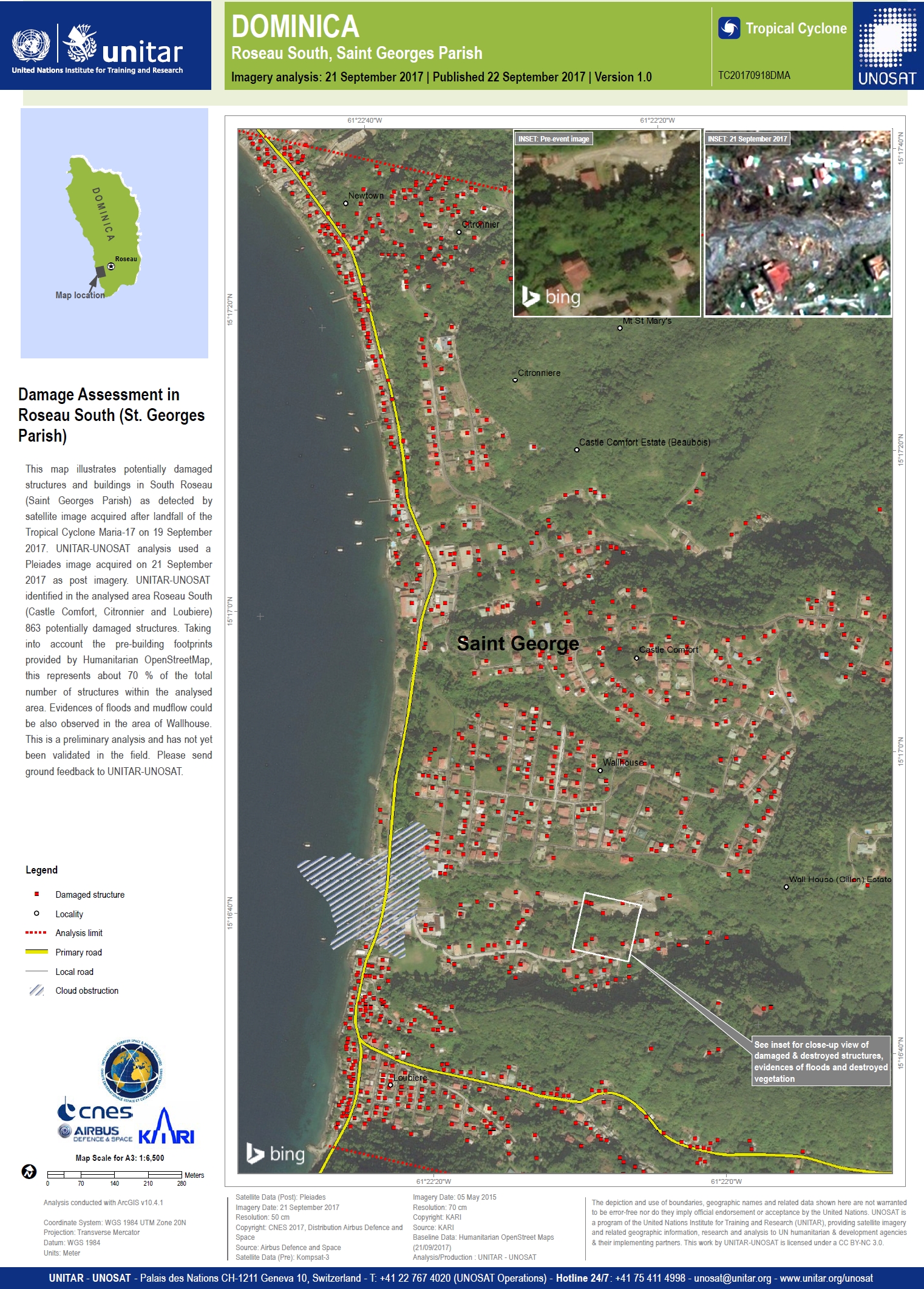
Damage assessment in South Roseau, Saint Georges Parish, Dominica
Direitos autorais: Pleiades © CNES (2017) - Distribution: Airbus Defence and Space, all rights reserved
KOMPSAT-3 © KARI
Map produced by UNITAR/UNOSAT
Information about the Product
Adquirida: Pleiades: 21/09/2017
KOMPSAT-3: 05/05/2015
Fonte: Pleiades / KOMPSAT-3
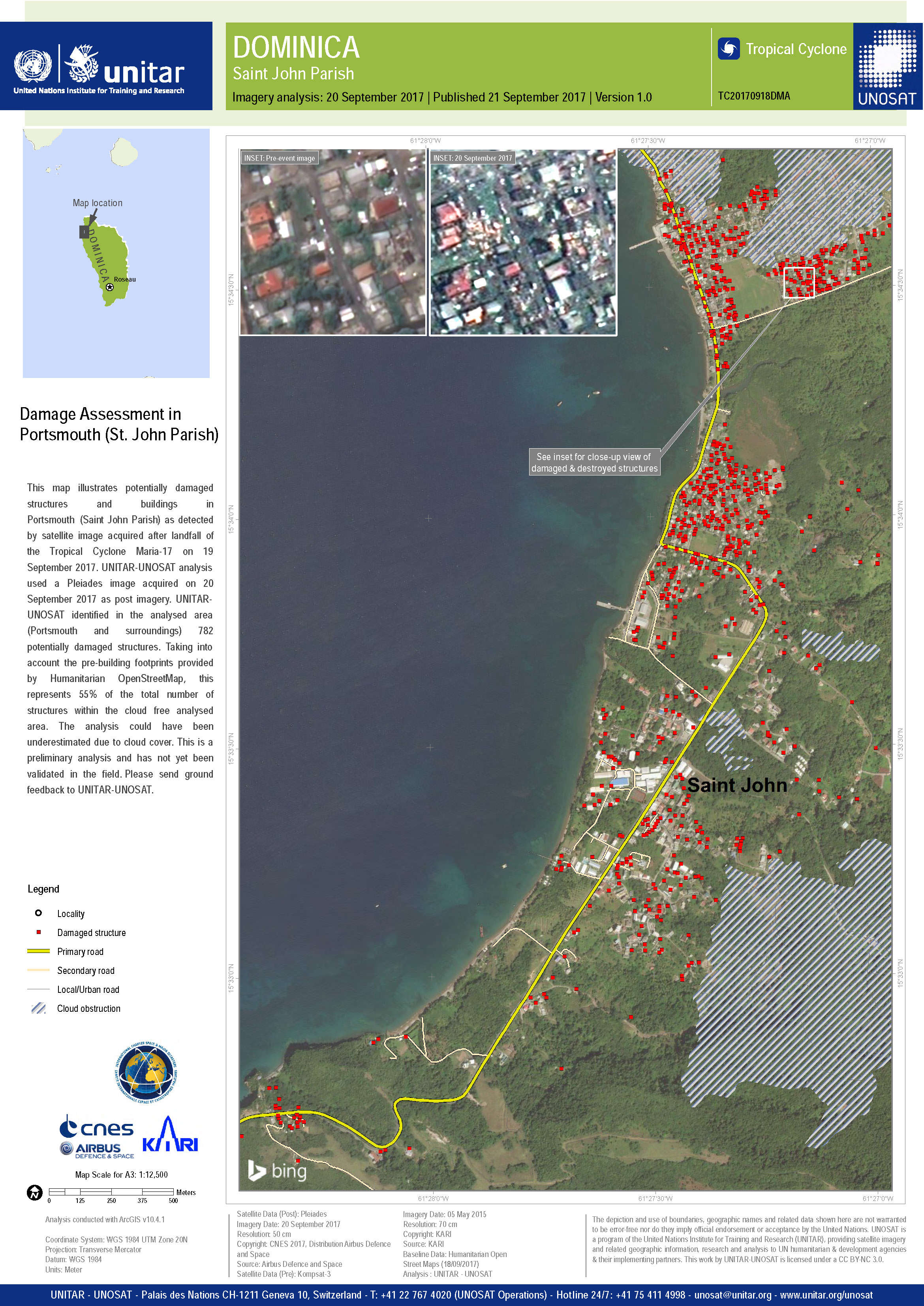
Damage assessment in Saint John Parish of Portsmouth, Dominica
Direitos autorais: Pleiades © CNES (2017) - Distribution: Airbus Defence and Space, all rights reserved
KOMPSAT-3 © KARI
Map produced by UNITAR/UNOSAT
Information about the Product
Adquirida: Pleiades: 20/09/2017
KOMPSAT-3: 05/05/2015
Fonte: Pleiades / KOMPSAT-3
 Voltar ao arquivo completo da Ativação
