 English
 Spanish
 French
 Chinese
 Russian
 Portuguese
 最新宪章启动
Charter activations
Flash Flooding in The Democratic Republic of the Congo
On Thursday 4 May 2023, torrential rain triggered landslides and caused extreme flooding which devastated two villages in the eastern region of the Democratic Republic of the Congo.
The rainfall in Kalehe territory in South Kivu province caused rivers to break their banks, inundating the villages of Bushushu and Nyamukubi. More than 400 people were killed making it one of the deadliest natural disasters in the country's recent history. Additionally, 3000 families lost their homes and both villages were unrecognisable after the disaster.
United Nations climates experts have stated that the high intensity and frequency of rainfall in Africa is due to rising temperatures. According to the UNDP, there has been a 134% increase in climate-fueled, flood-related disasters between 2000 and 2023.
Floods and landslides are not uncommon in South Kivu, which shares a border with Rwanda. Heavy rains also triggered flooding and landslides in Rwanda in early May, killing at least 130 people and destroying more than 5,000 homes.
| 事件地点: | Congo, The Democratic Republic Of The |
| 启动宪章的日期: | 2023-05-08 |
| 宪章启动时间: | 11:16 |
| 宪章启动时区: | UTC+02:00 |
| 宪章要求者: | UNITAR on behalf of UNOCHA |
| 启动ID: | 817 |
| 项目经理: | Teodoro Hunger (UNITAR/UNOSAT) |
Products

Preliminary satellite-derived landslide assessment - Kabare & Bukavu territory, Sud-Kivu Province, Democratic Republic of the Congo
Download full Report
版权: Includes Pleiades material © CNES (2023), Distribution Airbus DS.
Report produced by UNITAR / UNOSAT
Information about the Product
已获得: 12/05/2023
源: Pleiades
类别: Reference Map

Preliminary Satellite-Derived Landslide Assessment Report, Kalehe Territory, Sud-Kivu Province and Masisi Territory, Nord-Kivu Province, Democratic Republic of the Congo
Download full report
版权: Includes Pleiades material © CNES (2023), Distribution Airbus DS.
Report prepared by UNITAR / UNOSAT
Information about the Product
已获得: 10/05/2023
源: Pleiades
类别: Reference Map

Damage assessment in Nyabibwe Town, Kalehe Territory, Sud-Kivu Province, DR. of the Congo
版权: © (2023) DigitalGlobe, Inc., Longmont CO USA 80503. DigitalGlobe and the DigitalGlobe logos are trademarks of DigitalGlobe, Inc. The use and/or dissemination of this data and/or of any product in any way derived there from are restricted. Unauthorized use and/or dissemination is prohibited
Includes Pleiades material © CNES (2023), Distribution Airbus DS.
Map produced by UNITAR / UNOSAT
Information about the Product
已获得: WorldView-2: 10/04/2023
Pleiades: 09/05/2023
源: WorldView-2 / Pleiades
类别: Grading Map

Damage assessment in Chabondo village, Kalehe Territory, Sud-Kivu Province, DR. of the Congo
版权: Includes Pleiades material © CNES (2023), Distribution Airbus DS.
© (2023) DigitalGlobe, Inc., Longmont CO USA 80503. DigitalGlobe and the DigitalGlobe logos are trademarks of DigitalGlobe, Inc. The use and/or dissemination of this data and/or of any product in any way derived there from are restricted. Unauthorized use and/or dissemination is prohibited
Map produced by UNITAR / UNOSAT
Information about the Product
已获得: Pleiades: 09/05/2023
WorldView-2: 10/04/2023
源: Pleiades / WorldView-2
类别: Grading Map

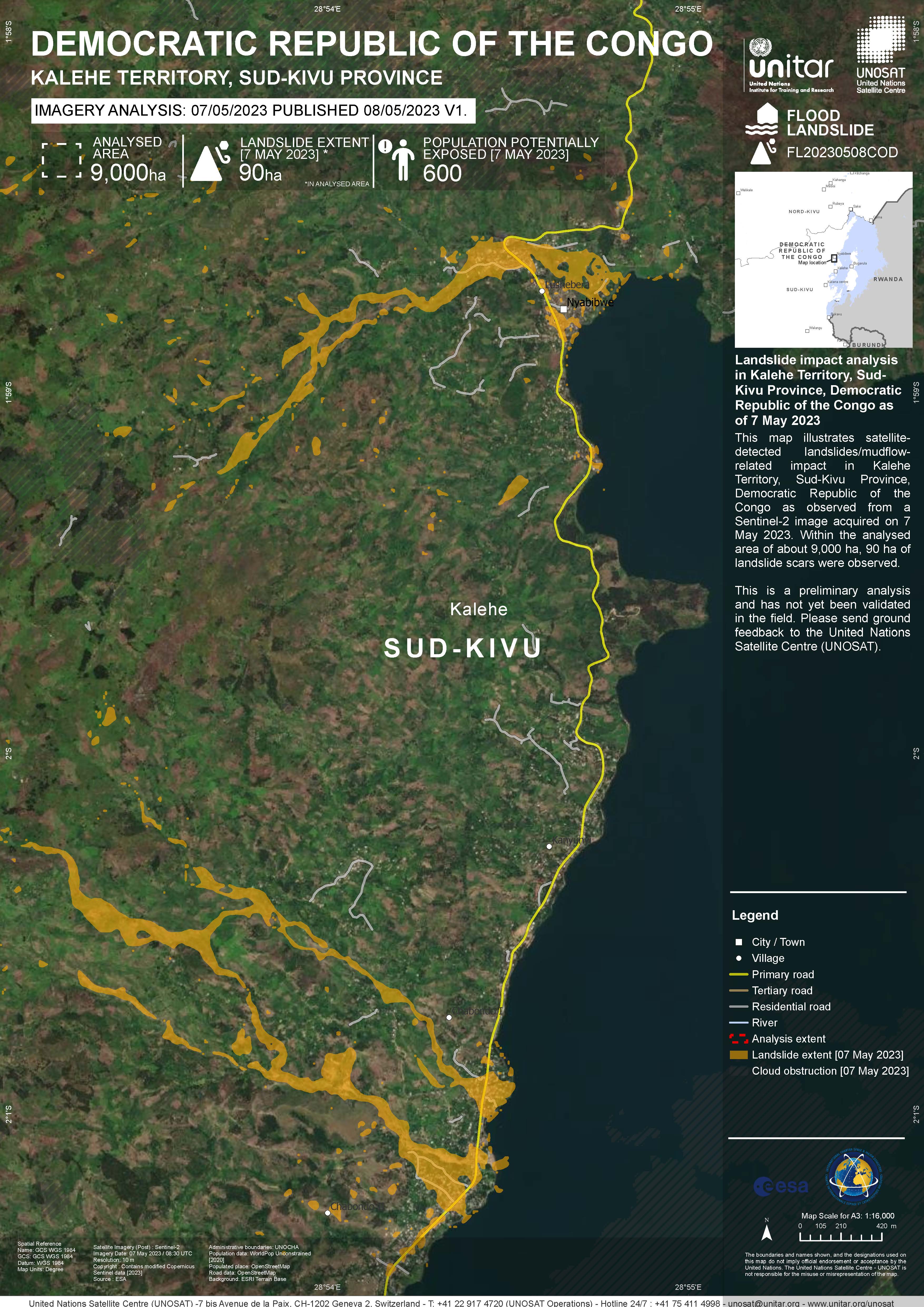
Landslide impact analysis in Kalehe Territory, Sud-Kivu Province, Democratic Republic of the Congo
版权: Contains modified Copernicus Sentinel data (2023)
Includes Pleiades material © CNES (2023), Distribution Airbus DS.
Map produced by UNITAR / UNOSAT
Information about the Product
已获得: Sentinel-2: 07/05/2023
Pleiades: 09/05/2023
源: Sentinel-2 / Pleiades
类别: Reference Map
 返回完整的响应档案

