 English
 Spanish
 French
 Chinese
 Russian
 Portuguese
 Dernière activation
Charter activations
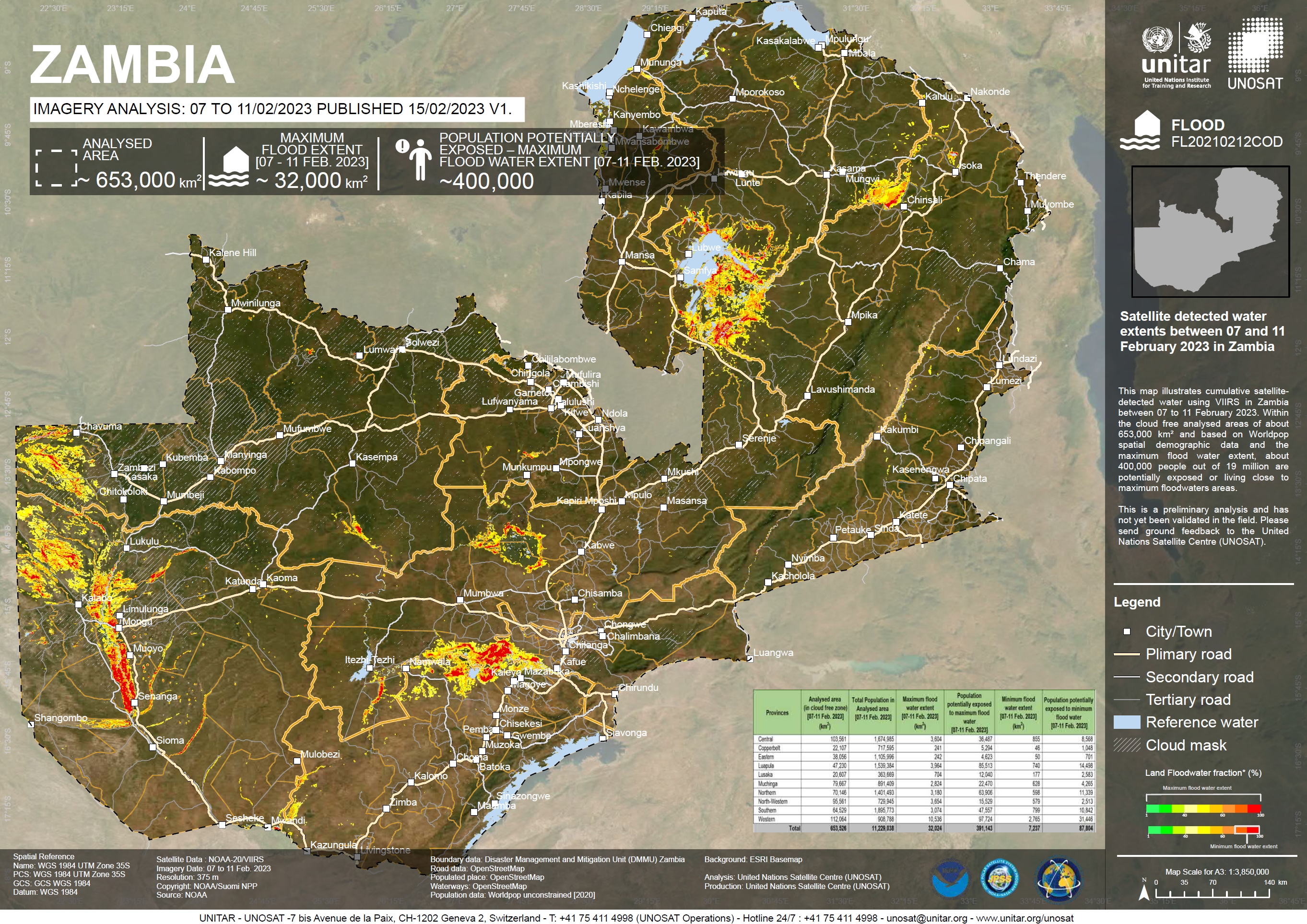
Flooding in Zambia
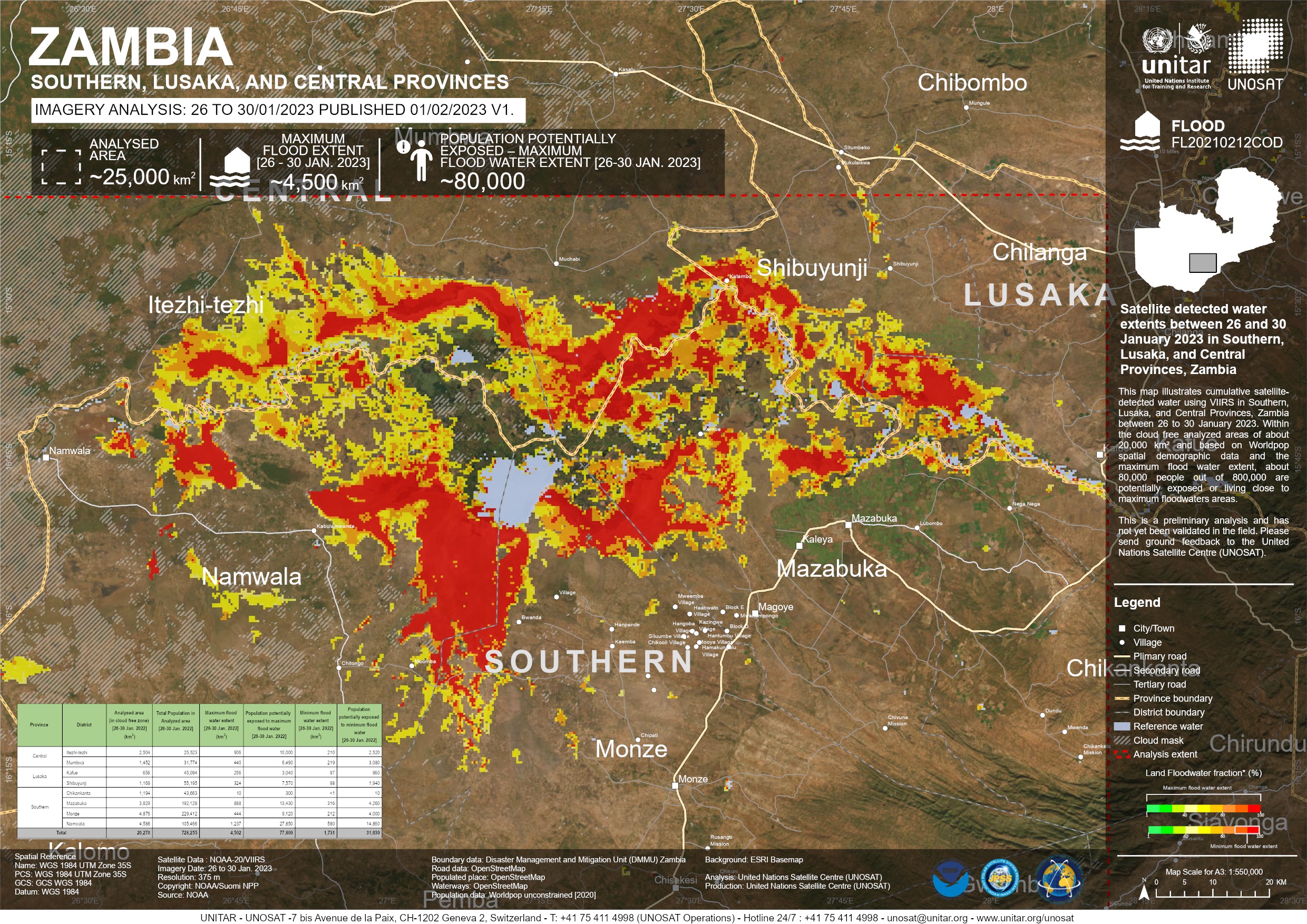
Zambia is experiencing severe flooding in Southern, Central, Lusaka provinces, thousands of people have been affected with the worst impacted areas being the districts of Luapula, Kapompo, Lukulu, Senanga, Kitwe, Mambwe, and Solwezi.
The Water Resources Management Authority (WARMA) has been issuing flood warnings since mid-January. Some rivers are expected to be high or experience a second peak well into February, including the Luapala river in Milenge district, the Kafue river in Kitwe district, and the Zambezi river in Lukulu and Senanga districts.
An estimated 15,000 people from 3,500 households were affected by flooding in Southern Province in January last year.
Related News and Resources| Location of Event: | Zambia |
| Date of Charter Activation: | 2023-01-30 |
| Time of Charter Activation: | 10:39 |
| Time zone of Charter Activation: | UTC+01:00 |
| Charter Requestor: | UNOOSA/UN-SPIDER on behalf of Disaster Management and Mitigation Unit (DMMU) of the Office of the Vice President of Zambia |
| Activation ID: | 796 |
| Project Management: | Giriraj Amarnath (International Water Management Institute) |
| act-value-adders: | Suwanan Sateiandee (UNITAR) |
Products
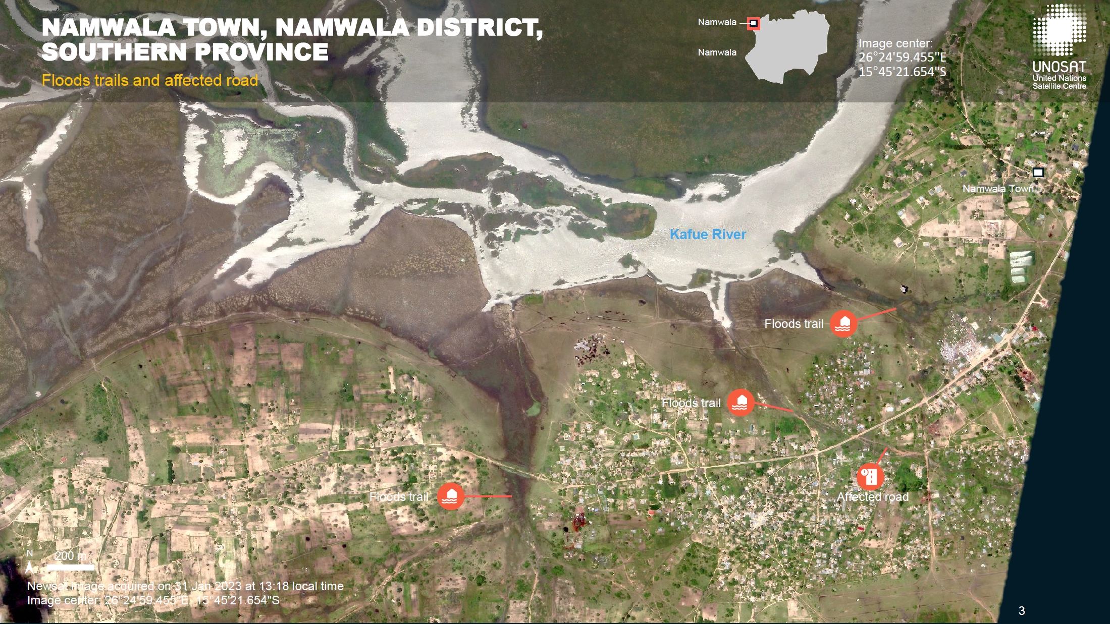
Preliminary Satellite-derived Flood Assessment, Namwala Town, Namwala District, Southern Province, Zambia
Download the Full Report
Copyright: NewSat © Satellogic (2023)
Contains modified Copernicus Sentinel data (2023)
Report produced by UNOSAT/UNITAR.
Information about the Product
Acquired: Sentinel-2 : 03/12/2022
NewSat: 31/01/2023
Source: NewSat and Sentinel-2
Category: Reference Map
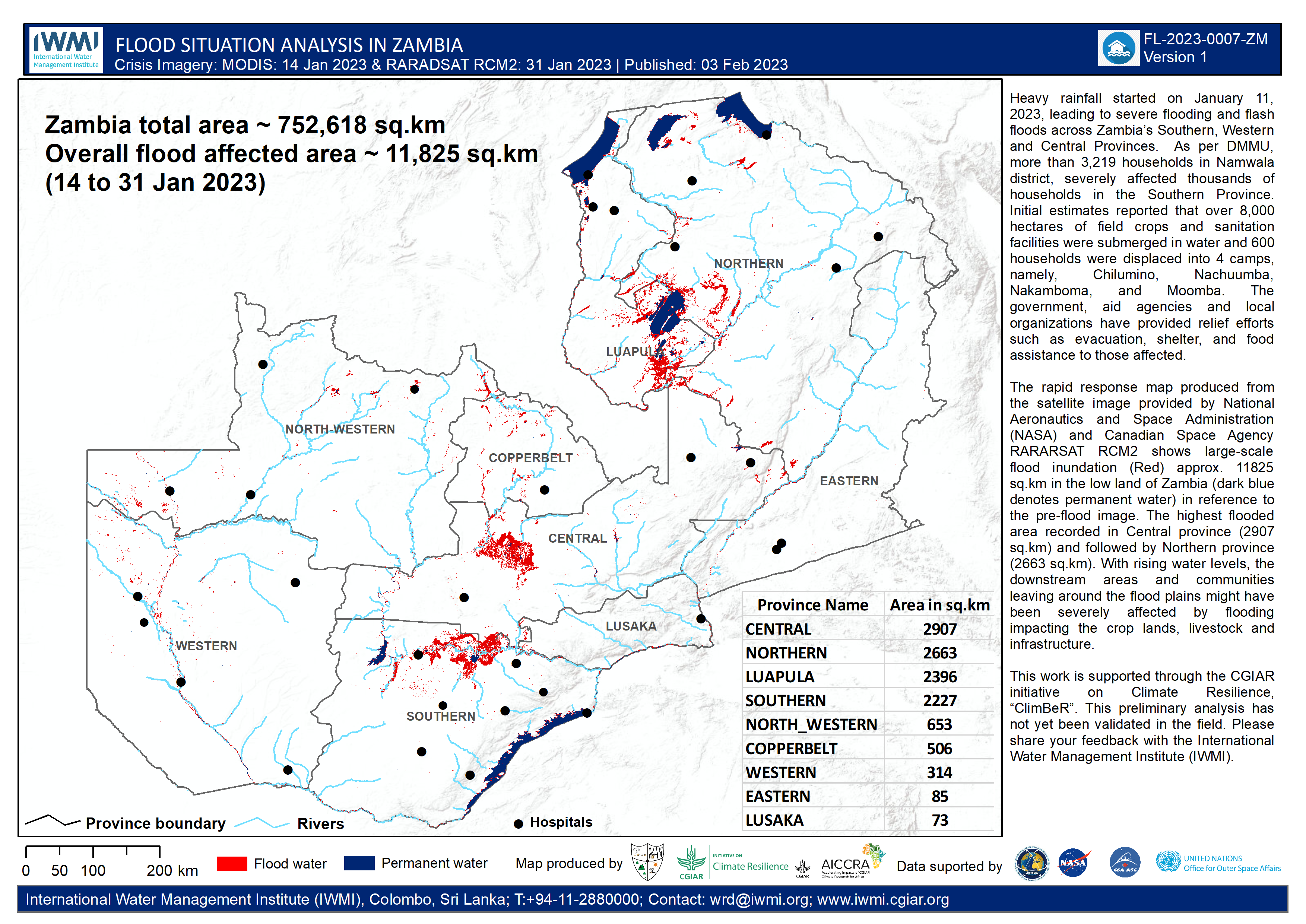
Flood situation analysis in Zambia
Copyright: RADARSAT Constellation Mission Imagery © Government of Canada (2023) - RADARSAT is an official mark of the Canadian Space Agency.
Map produced by IWMI and CGIAR Climate Resilience Initiative and Accelerating the Impact of CGIAR Climate Research for Africa (AICCRA).
Information about the Product
Acquired: 31/01/2023
Source: RCM
Category: Reference Map
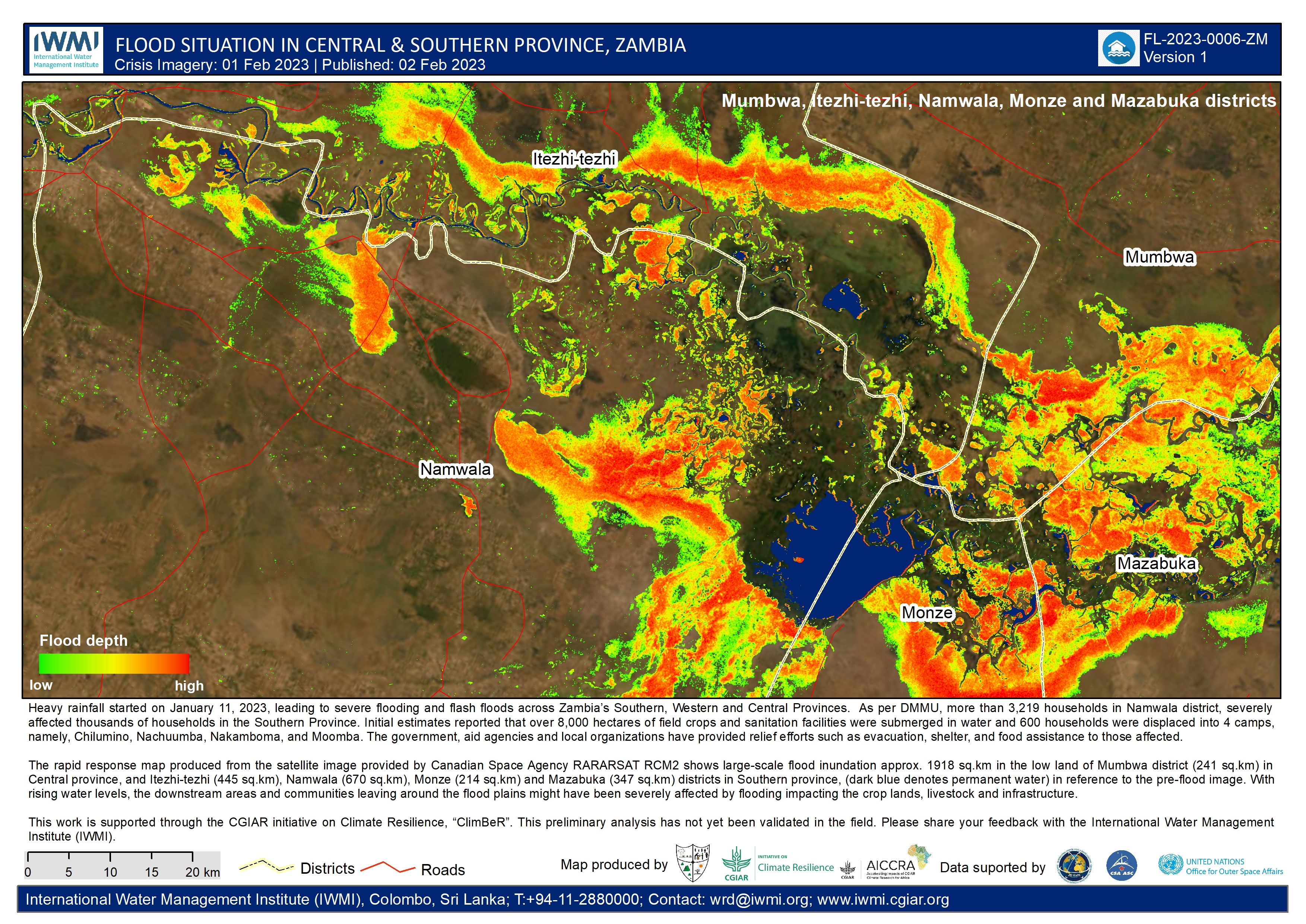
Flood inundation depth in the Central and Southern Provinces, Zambia
Copyright: RADARSAT Constellation Mission Imagery © Government of Canada (2023)
RADARSAT is an official mark of the Canadian Space Agency.
Map produced by IWMI and CGIAR Climate Resilience Initiative and Accelerating the Impact of CGIAR Climate Research for Africa (AICCRA).
Information about the Product
Acquired: 01/02/2023
Source: RCM
Category: Reference Map
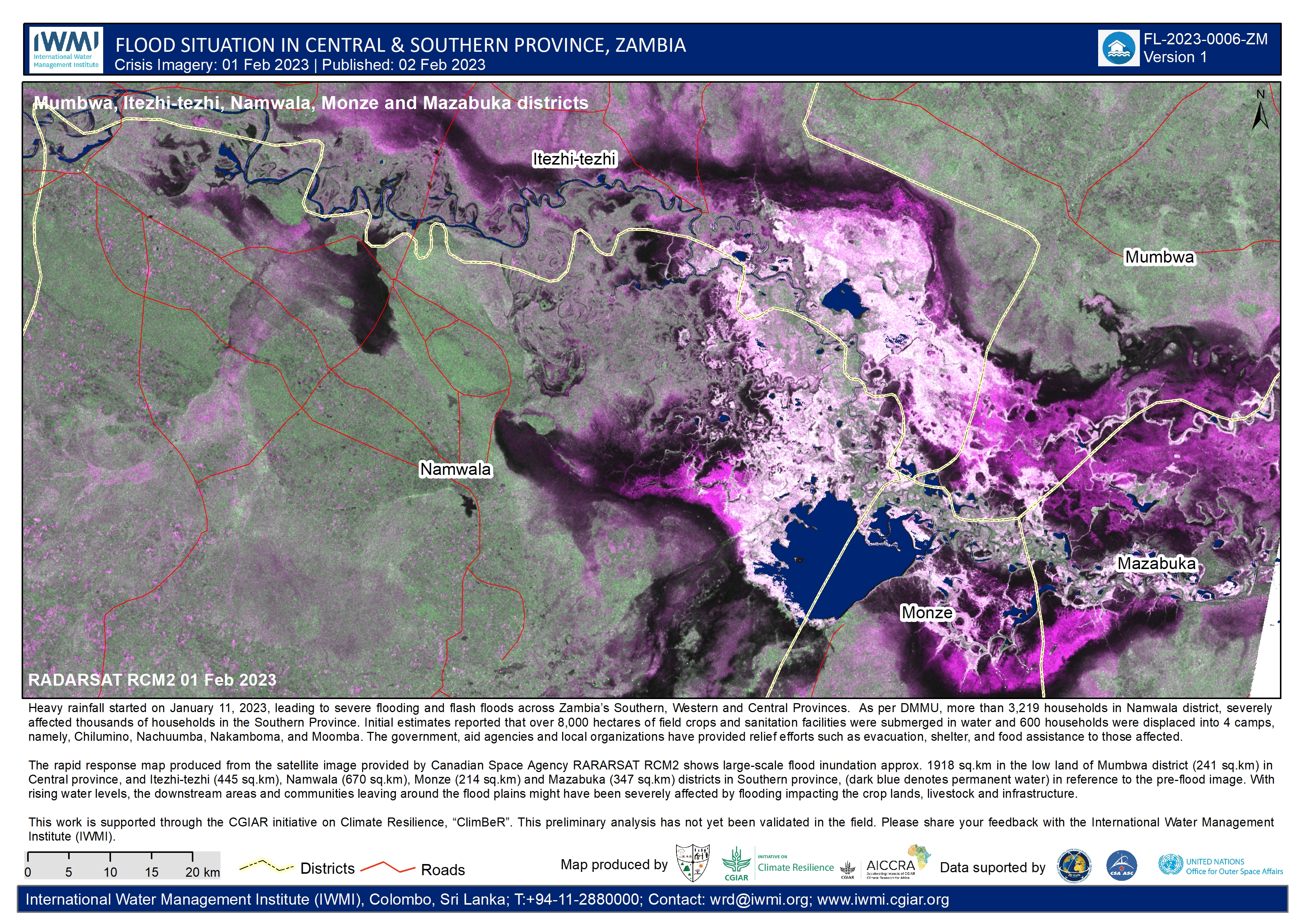
Flood situation in the Central and Southern Provinces, Zambia
Copyright: RADARSAT Constellation Mission Imagery © Government of Canada (2023)
RADARSAT is an official mark of the Canadian Space Agency.
Map produced by IWMI and CGIAR Climate Resilience Initiative and Accelerating the Impact of CGIAR Climate Research for Africa (AICCRA).
Information about the Product
Acquired: 01/02/2023
Source: RCM
Category: Reference Map
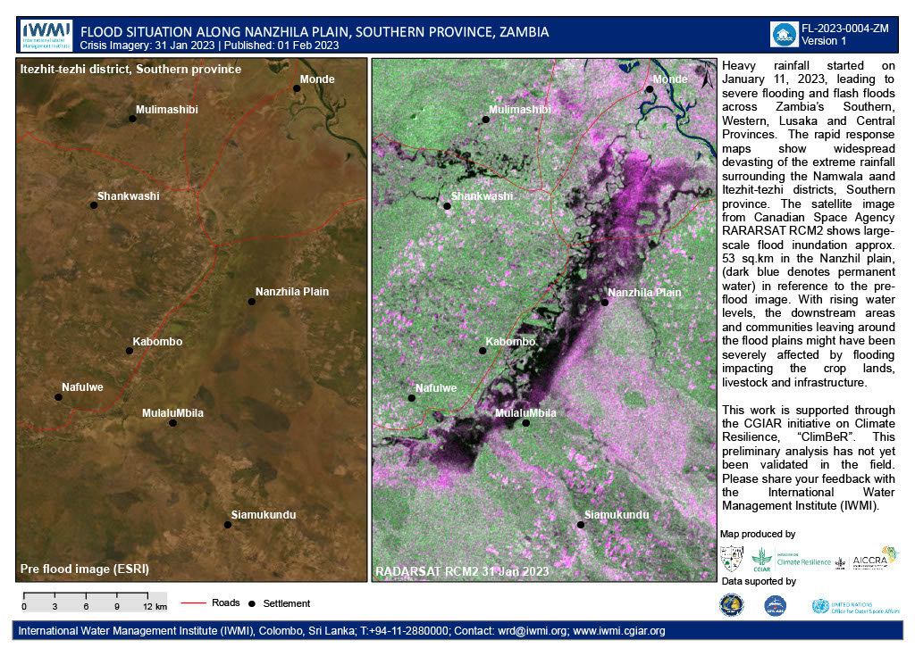
Flood situation along the Nanzhila plain, Southern Province, Zambia
Copyright: RADARSAT Constellation Mission Imagery © Government of Canada (2023) - RADARSAT is an official mark of the Canadian Space Agency.
Map produced by IWMI and CGIAR Climate Resilience Initiative and Accelerating the Impact of CGIAR Climate Research for Africa (AICCRA).
Information about the Product
Acquired: 31/01/2023
Source: RCM
Category: Reference Map
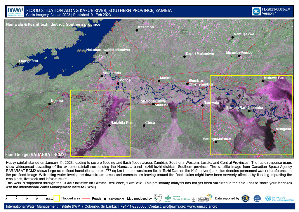
Flood situation along the Kafue river, Southern Province, Zambia
Copyright: RADARSAT Constellation Mission Imagery © Government of Canada (2023) - RADARSAT is an official mark of the Canadian Space Agency.
Map produced by IWMI and CGIAR Climate Resilience Initiative and Accelerating the Impact of CGIAR Climate Research for Africa (AICCRA).
Information about the Product
Acquired: 31/01/2023
Source: RCM
Category: Reference Map
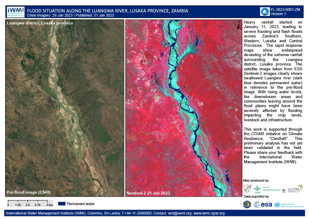
Flood situation along the Luangwa river, Lusaka province, Zambia
Copyright: Contains modified Copernicus Sentinel data (2023)
Map produced by IWMI and CGIAR Climate Resilience Initiative and Accelerating the Impact of CGIAR Climate Research for Africa (AICCRA).
Information about the Product
Acquired: 29/02/2023
Source: Sentinel-2
Category: Reference Map
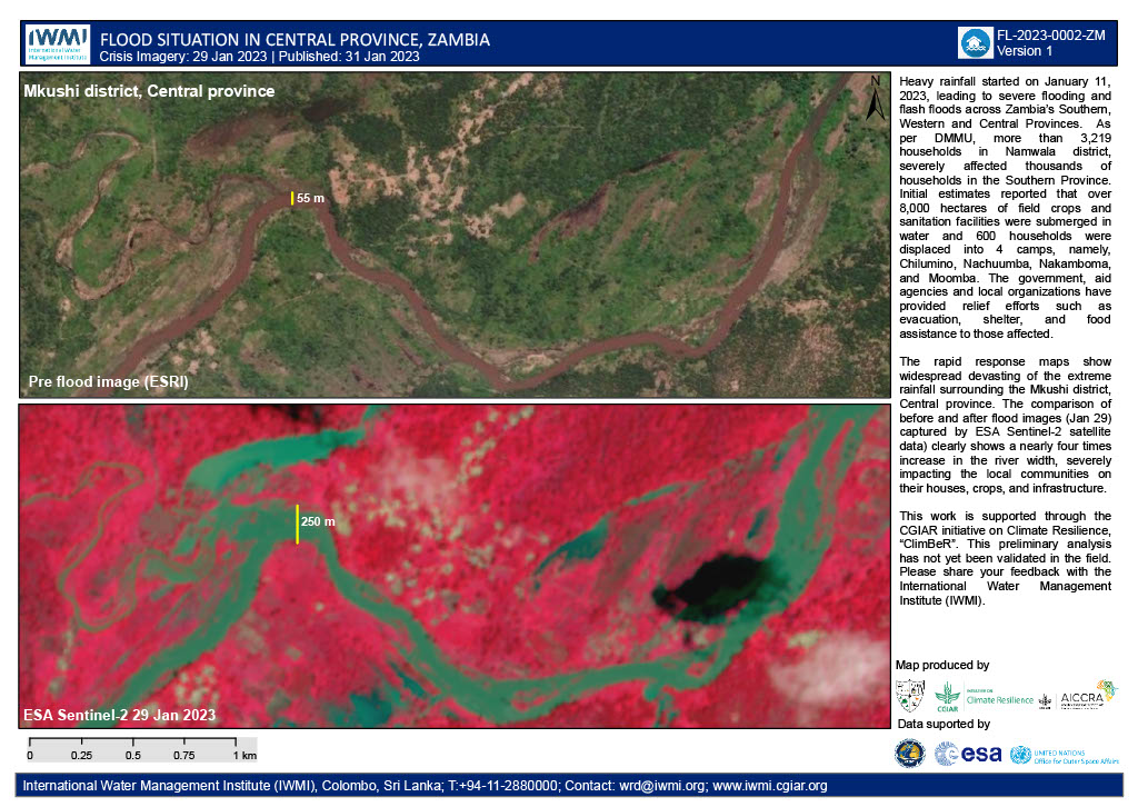
Areas affected by flooding in the Mkush district, Central Province, Zambia
Copyright: Contains modified Copernicus Sentinel data (2023)
Map produced by IWMI and CGIAR Climate Resilience Initiative and Accelerating the Impact of CGIAR Climate Research for Africa (AICCRA).
Information about the Product
Acquired: 29/01/2023
Source: Sentinel-2
Category: Reference Map
 Back to the full activation archive

