 English
 Spanish
 French
 Chinese
 Russian
 Portuguese
 Dernière activation
Charter activations
Tropical Cyclone Seroja in Timor-leste
Tropical Cyclone Seroja passed close to the coast of Timor-Leste on 4 April 2021, and the slow-moving storm brought heavy rain that caused floods and landslides.
27 people were killed in the landslides and floods, and approximately 10,000 people were affected, with at least 8 still missing. Most of the damage occurred in Dili municipality, in which the capital city of Dili is located. Dili hosts the highest population in the country and the city experienced extensive flooding, which the Prime Minister described as one of the most devastating incidents the nation has experienced in the past 40 years.
The flood waters swept many homes away and caused damage to roads, making travel within the city difficult.
The storm also caused a loss of power throughout the country and damaged the nation's pharmacy containing storage of their COVID-19 vaccines.
| Type of Event: | Floods, landslides, cyclone |
| Location of Event: | Timor-leste |
| Date of Charter Activation: | 2021-04-07 |
| Time of Charter Activation: | 16:23 |
| Time zone of Charter Activation: | UTC+02:00 |
| Charter Requestor: | UNITAR on behalf of UN Resident Coordinator Office - Timor Leste ADRC |
| Activation ID: | 701 |
| Project Management: | UNITAR/UNOSAT |
Products


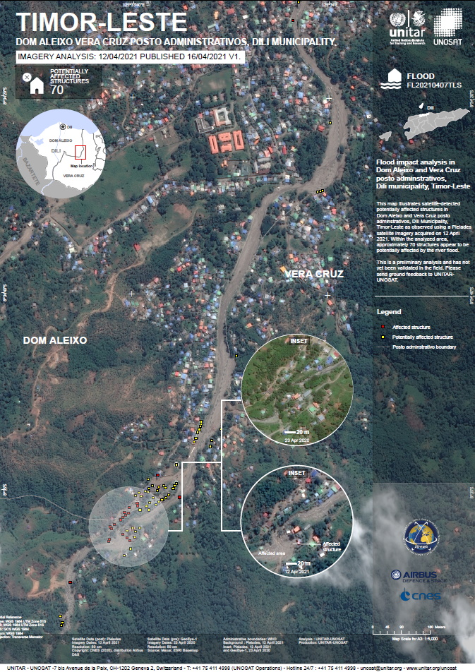
Flood impact analysis in Dom Aleixo and Ver Cruz post adminstrativos, Dili municipality, Timor-Leste
Copyright: Includes Pleiades material © CNES (2021), Distribution Airbus DS.
GeoEye-1 © DigitalGlobe Inc.
Map produced by UNITAR/UNOSAT
Information about the Product
Acquired: GeoEye: 23/04/2020
Pleiades: 12/04/2021
Source: Pleiades / GeoEye
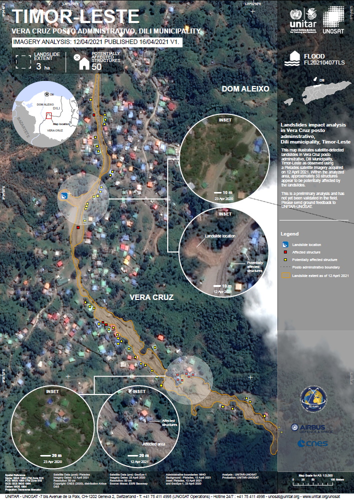
Landslides impact analysis in Vera Cruz posto adminstrativo, Dili municipality, Timor-Leste
Copyright: Includes Pleiades material © CNES (2021), Distribution Airbus DS.
GeoEye-1 © DigitalGlobe Inc.
Map produced by UNITAR/UNOSAT
Information about the Product
Acquired: GeoEye: 23/04/2020
Pleiades: 12/04/2021
Source: Pleiades / GeoEye
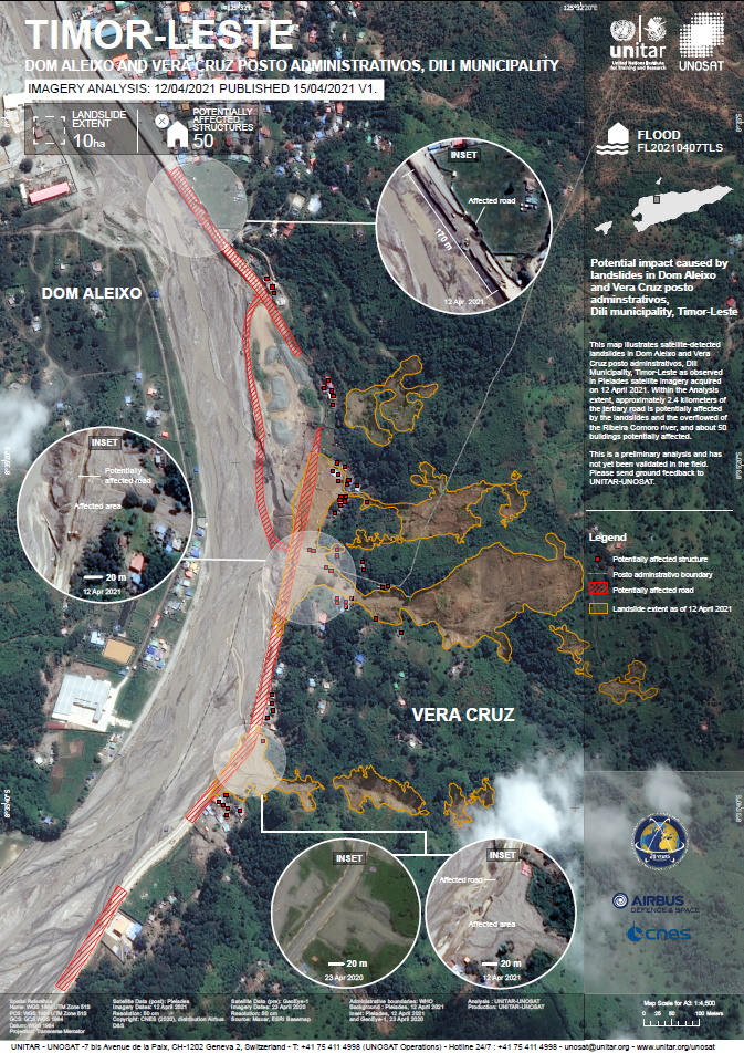
Potential impact caused by landslides in Dom Aleixo and Vera Cruz posto adminstrativos, Dili municipality, Timor-Leste
Copyright: Includes Pleiades material © CNES (2021), Distribution Airbus DS.
GeoEye-1 © DigitalGlobe Inc.
Map produced by UNITAR/UNOSAT
Information about the Product
Acquired: GeoEye: 23/04/2020
Pleiades: 12/04/2021
Source: GeoEye / Pleiades
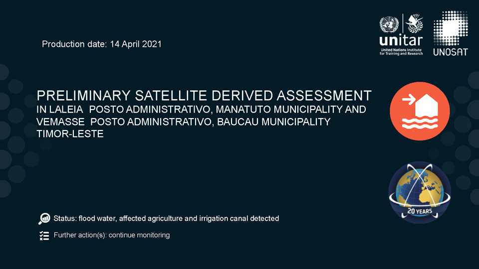
Preliminary satellite derived assessment of Manuatuto and Baucau Municipality, Timor-Leste
Download the full report
Copyright: © (2021) DigitalGlobe, Inc., Longmont CO USA 80503. DigitalGlobe and the DigitalGlobe logos are trademarks of DigitalGlobe, Inc. The use and/or dissemination of this data and/or of any product in any way derived there from are restricted. Unauthorized use and/or dissemination is prohibited
Report produced by UNITAR/UNOSAT
Information about the Product
Acquired: 10/04/2021
Source: WorldView-2
Preliminary satellite derived flood assessment of Ermera, Bobonaro and Covalima Municipalities
Download the full report
Copyright: © Planet Labs Inc. (2021)
Report produced by UNITAR/UNOSAT
Information about the Product
Acquired: 12/04/2021
Source: PlanetScope
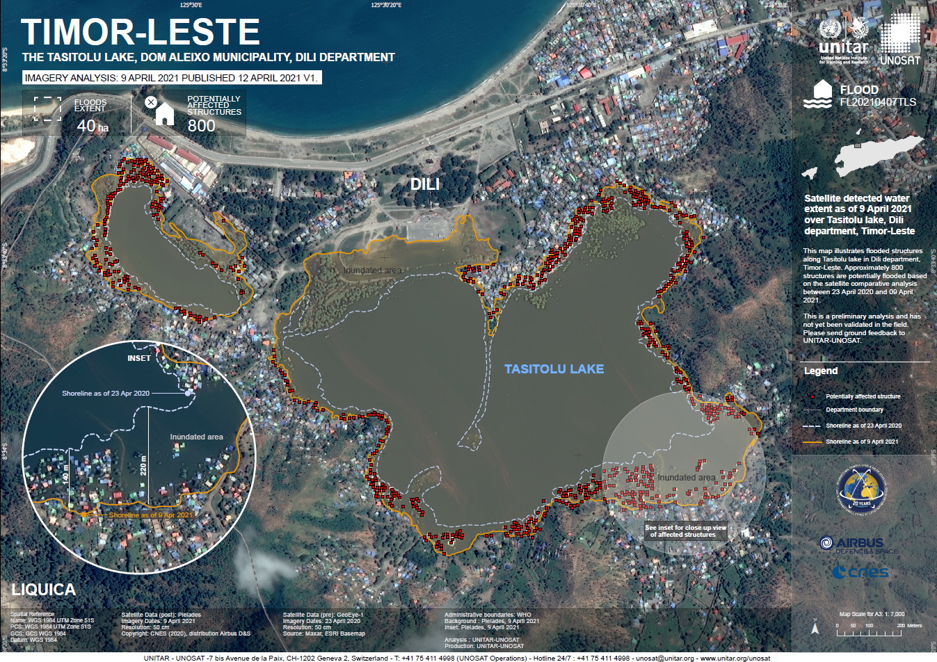
Preliminary Satellite-Derived Flood Assessment in Dili and Liquica Departments, Timor-Leste
Download the full report
Copyright: Includes Pleiades material © CNES (2021), Distribution Airbus DS.
Report produced by UNITAR/UNOSAT
Information about the Product
Acquired: 08/04/2021
Source: Pleiades

 Back to the full activation archive
