Minimiser Dernière activation

Charter activations

Earthquake in Japan

A magnitude 7.6 earthquake struck Japan on 1 January, leaving 48 dead and destroying hundreds of buildings.

7.6 is a major earthquake on the Richter scale, and the initial earthquake was followed by many smaller tremors, reaching as high as 4.9 magnitude.

The earthquake occurred at 07:10 UTC, in the Noto Peninsula of Ishikawa Prefecture. Hundreds of buildings were destroyed by the earthquake or by fires that followed. Roads and power infrastructure were also damaged, leaving over 30,000 people without power and affecting rescue efforts.

Rescue operations continued since the earthquake, and over 57,000 people were evacuated. The death toll risked to rise in the aftermath as the search continued, but thousands of emergency responders worked through the debris to find any survivors.

The area was put on alert for the impact of further tremors and tsunami warnings were in place following the earthquake, but were later lifted.

Type of Event:Earthquake
Location of Event:Japan
Date of Charter Activation:2024-01-02
Time of Charter Activation:13:25
Time zone of Charter Activation:UTC+09:00
Charter Requestor:ADRC
Activation ID:857
Project Management:Masahiko Nagai (Yamaguchi University)
act-value-adders:University of Tokyo
Fumio YAMAZAKI (Chiba University)
Tokyo Denki University
Kohki ITOH (JAXA)
Hitoshi Taguchi (National Research Institute for Earth Science and Disaster Resilience (NIED))
Hiromichi FUKUI (Chubu University)
Yuzo SUGA (Hiroshima Institute of Technology)
Shiro KAWAKITA (JAXA)
Tsuyoshi Eguchi (Yamaguchi University)
Atsuko NONOMURA (Kagawa University)

Products

Landslide Damage along Prefectural Road 38 due to the Noto Peninsula Earthquake, Japan

Copyright: © 2004 GeoEye NextView License
Map produced by Yamaguchi University.

Information about the Product

Acquired: 02/01/2024

Source: GeoEye-1

Category: Delineation Map

Landslide Damage in Niemachi due to the Noto Peninsula Earthquake, Japan

Copyright: © 2004 GeoEye NextView License
Map produced by Yamaguchi University.

Information about the Product

Acquired: 02/01/2024

Source: GeoEye-1

Category: Delineation Map

Areas affected by Flooding and Landslides in Wajima City, Ishikawa Prefecture, Japan

Copyright: © 2004 GeoEye NextView License
Map produced by Chiba University.

Information about the Product

Acquired: 02/01/2024

Source: GeoEye-1

Category: Delineation Monitoring Maps

Collapsed Cliffs on Mitsuke Island, Suzu City, Ishikawa Prefecture, Japan

Copyright: © 2004 GeoEye NextView License
Map produced by Chiba University.

Information about the Product

Acquired: 02/01/2024

Source: GeoEye-1

Category: Delineation Monitoring Maps

Areas affected by Landslides and Debris Flows in Japan

Copyright: © 2004 GeoEye NextView License
Map produced by Kagawa University.

Information about the Product

Acquired: 02/01/2024

Source: GeoEye-1

Category: Grading Map

Areas affected by Landslides on the slope near the Haseno domon shin-tunnel, Japan

Copyright: © 2004 GeoEye NextView License
Map produced by Kagawa University.

Information about the Product

Acquired: 02/01/2024

Source: GeoEye-1

Category: Reference Map

Areas affected by fire on the Noto Peninsula in Japan

Copyright: © 2004 GeoEye NextView License
Map produced by Chiba University.

Information about the Product

Acquired: 02/01/2024

Source: GeoEye-1

Category: Delineation Map

Landslide Occurrence in Mauramachi, Ishikawa, Japan

Copyright: © 2004 GeoEye NextView License
Map produced by Yamaguchi University.

Information about the Product

Acquired: 02/01/2024

Source: GeoEye-1

Category: Delineation Map

Areas affected by Landslides after the Noto Peninsula Earthquake, Japan

Copyright: © 2004 GeoEye NextView License
Map produced by Kagawa University.

Information about the Product

Acquired: 02/01/2024

Source: GeoEye-1

Category: Reference Map

Landslides after the Noto Peninsula Earthquake in the Northern City of Suzu, Japan

Copyright: © 2004 GeoEye NextView License
Map produced by IDEAS (International Digital Applied Services Research Group).

Information about the Product

Acquired: 02/01/2024

Source: GeoEye-1

Category: Delineation Map

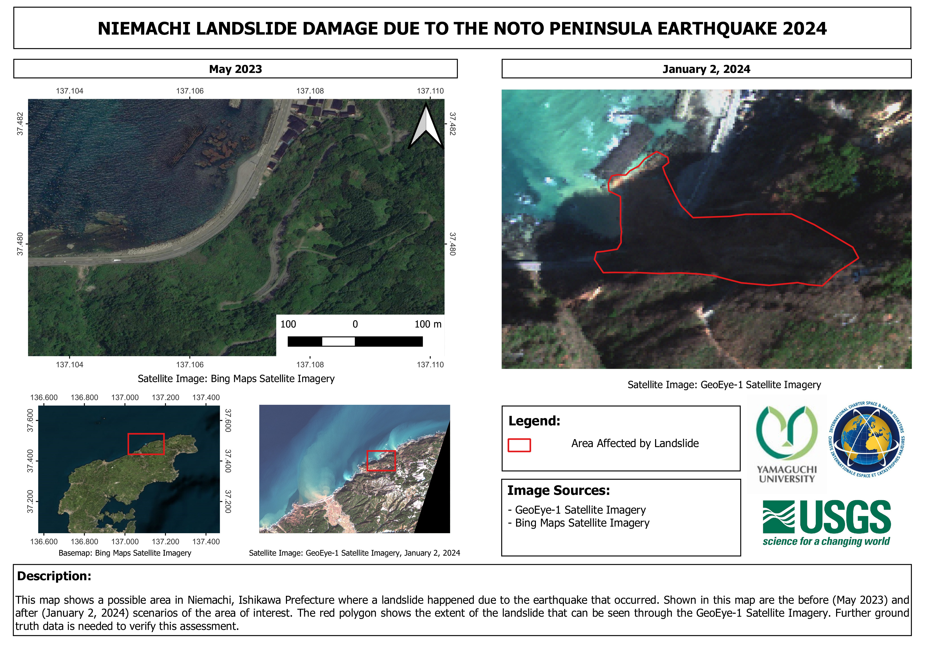
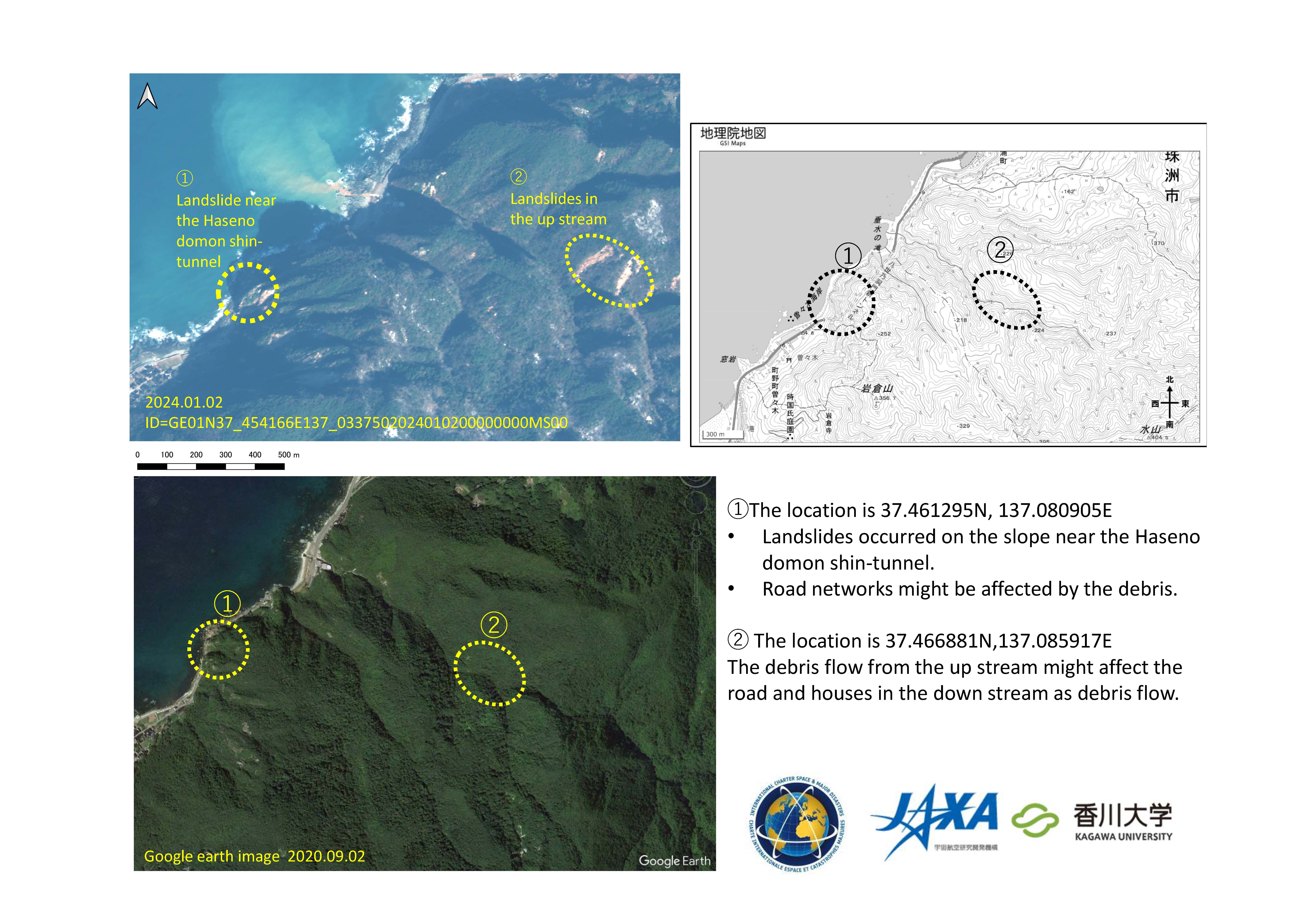
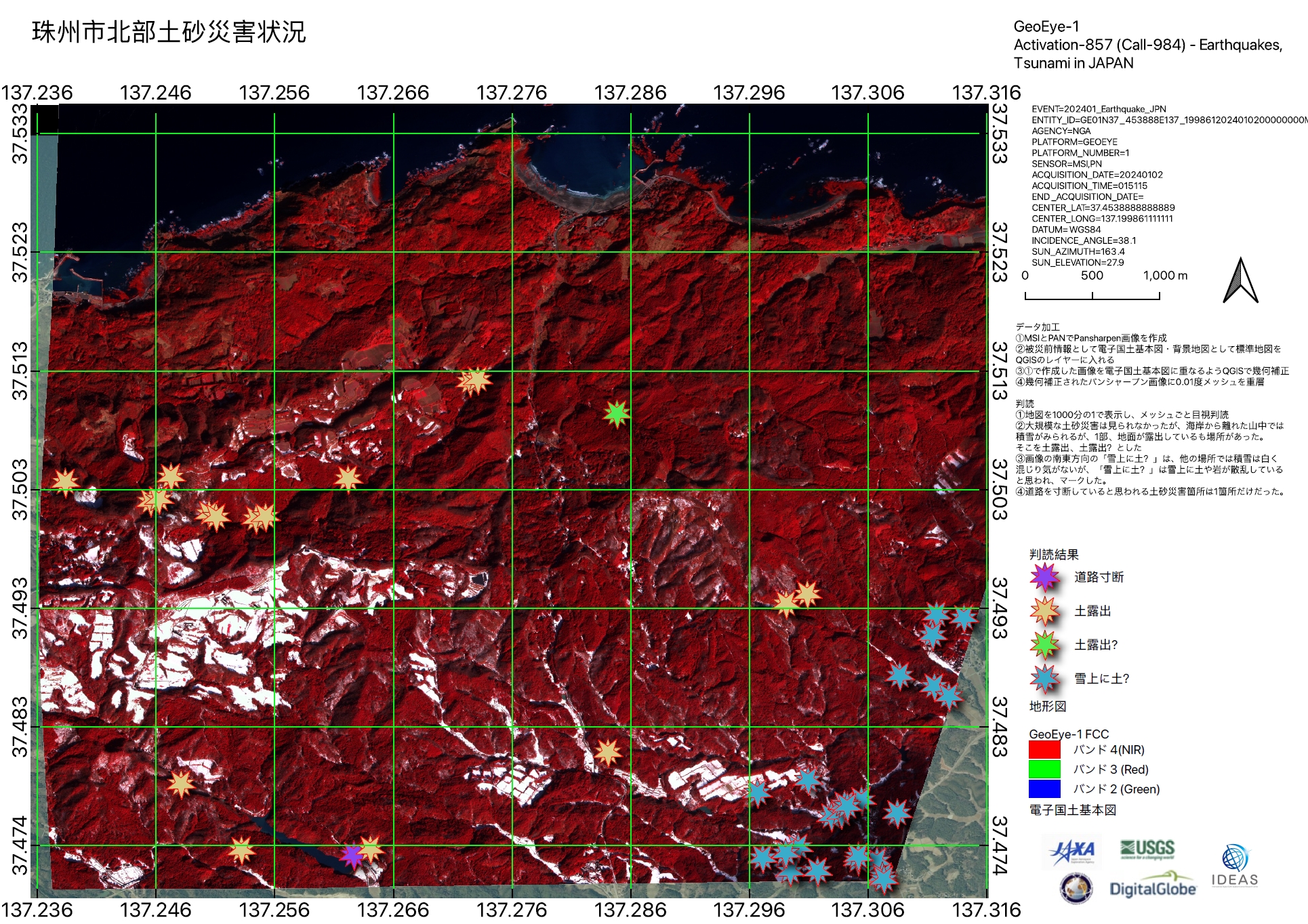
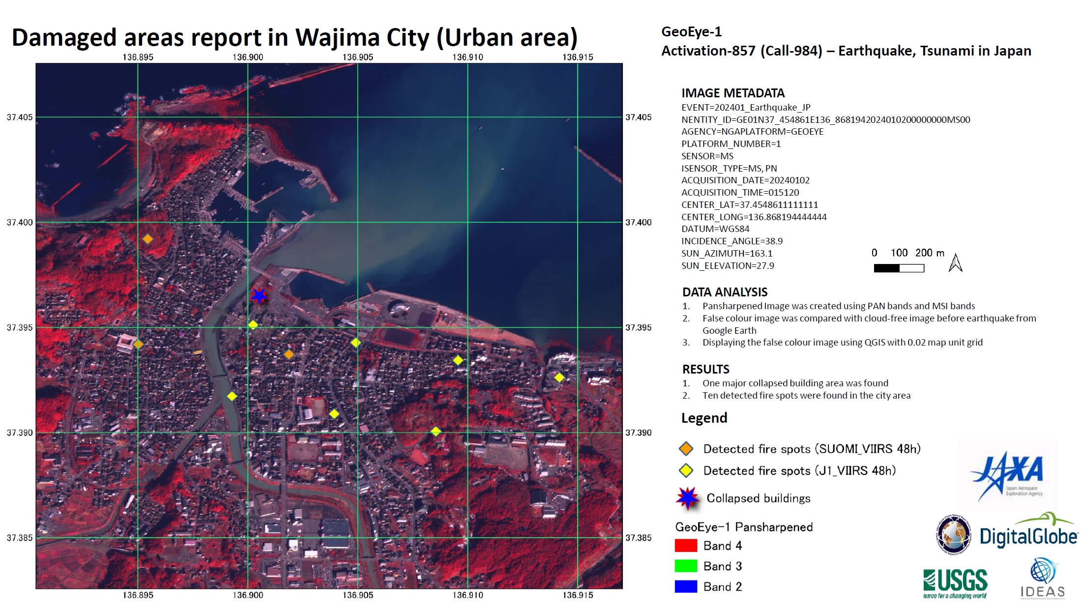
Post-Earthquake Damage, including Landslides and Fires, detected in Wajima city, Japan

Download the Full Report

Copyright: © 2004 GeoEye NextView License
Report produced by JAXA.

Information about the Product

Acquired: 02/01/2024

Source: GeoEye-1

Category: Delineation Map

Areas affected by earthquake-induced landslides in Japan

Copyright: © 2004 GeoEye NextView License
Map produced by Hiroshima Institute of Technology.

Information about the Product

Acquired: 02/01/2024

Source: GeoEye-1

Category: Delineation Map

Areas affected by earthquake-induced landslides in Japan

Copyright: © 2004 GeoEye NextView License
Map produced by Hiroshima Institute of Technology.

Information about the Product

Acquired: 02/01/2024

Source: GeoEye-1

Category: Delineation Map

Areas affected by earthquake-induced landslides in Suzu-City, Japan

Copyright: © 2004 GeoEye NextView License
Map produced by Hiroshima Institute of Technology.

Information about the Product

Acquired: 02/01/2024

Source: GeoEye-1

Category: Delineation Map

Detection of Landslides due to earthquakes in Noto, Japan

Copyright: Includes material © AIRBUS DS (2024)
Map produced by The "Center for Research and Application of Satellite Remote Sensing" in Yamaguchi University, Japan.

Information about the Product

Acquired: 04/01/2024

Source: SPOT-6

Category: Reference Map

Landslide caused by 2024 Noto Peninsula Earthquake, Japan

Copyright: © 2004 GeoEye NextView License
Map produced by Hiroshima Institute of Technology.

Information about the Product

Acquired: 02/01/2024

Source: GeoEye-1

Category: Delineation Map

Back to the full activation archive