Minimizar Última Activación

Charter activations

Flood in Vietnam

Tropical storms have brought heavy rainfall and high wind speeds causing severe flooding across Vietnams central provinces. At least 23 people have been killed and 14 people are reported missing.

Local authorities have evacuated 46,000 people from the worst affected areas. Over 100,000 homes have been flooded. The national disaster management authority also reported damage to roads and bridges and over 584 hectares of crops are indundated.

Weather forecasts have predicted further heavy rainfall in the coming days as Storm Nangka makes landfall. Nangka is expected to bring 400mm of rainfall adding to already high water levels.

News and resources:

Type of Event:Floods
Location of Event:Vietnam
Date of Charter Activation:2020-10-15
Time of Charter Activation:17:12
Time zone of Charter Activation:UTC+02:00
Charter Requestor:UNITAR on behalf of United Nations Office for the Coordination of Humanitarian Affairs (OCHA)
Activation ID:680
Project Management:UNITAR/UNOSAT

Products

Satellite detected waters in Quang Tri Province of Vietnam as of 25 October 2020

Copyright: Contains modified Copernicus Sentinel data (2020)
Maps produced by UNITAR/UNOSAT

Information about the Product

Acquired: 24/10/2020

Source: Sentinel-1

Satellite detected waters in Thua Thien Hue Province of Vietnam as of 25 October 2020

Copyright: Contains modified Copernicus Sentinel data (2020)
Map produced by UNITAR/UNOSAT

Information about the Product

Acquired: 24/10/2020

Source: Sentinel-1

Preliminary satellite-derived flood assessment Dong Hoi City, Bo Trach and Quang Ninh District, Quang Binh Province, Vietnam

Download the full report

Copyright: Includes Pleiades material © CNES (2020), Distribution Airbus DS.
Report produced by UNITAR/UNOSAT

Information about the Product

Acquired: 23/10/2020

Source: Pleiades
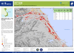
Satellite detected waters in Thua Thien Hue Province of Vietnam as of 22 October 2020

Copyright: Contains modified Copernicus Sentinel data (2020)
Map produced by UNITAR/UNOSAT

Information about the Product

Acquired: 22/10/2020

Source: Sentinel-1

Satellite detected waters in Quang Tri Province of Vietnam as of 22 October 2020

Copyright: Contains modified Copernicus Sentinel data (2020)
Map produced by UNITAR/UNOSAT

Information about the Product

Acquired: 22/10/2020

Source: Sentinel-1

VIIRS 1-day flood extent from NOAA-20 / Suomi NPP over Vietnam

Copyright: NOAA - NOAA-20/Suomi NPP
Map produced by NOAA / JPSS

Information about the Product

Acquired: 22/10/2020

Source: NOAA / Suomi NPP

Satellite detected waters in Quang Nam Province of Vietnam as of 20 October 2020

Copyright: © KARI (2020)
Map produced by UNITAR/UNOSAT

Information about the Product

Acquired: 20/10/2020

Source: KOMPSAT-5

Satellite detected waters in Northern of Quang Binh province of Vietnam as of 19 October 2020

Copyright: © KARI (2020)
Map produced by UNITAR - UNOSAT

Information about the Product

Acquired: 19/10/2020

Source: KOMPSAT-5

Satellite detected waters in Quang Binh Province of Vietnam as of 22 October 2020

Copyright: Contains modified Copernicus Sentinel data (2020)
Map produced by UNITAR - UNOSAT

Information about the Product

Acquired: 22/10/2020

Source: Sentinel-1

Satellite detected waters in Ha Tinh and Nghe An Provinces of Vietnam as of 21 October 2020

Copyright: Contains modified Copernicus Sentinel data (2020)
Map produced by UNITAR/UNOSAT

Information about the Product

Acquired: 21/10/2020

Source: Sentinel-1

Satellite detected waters in Ha Tinh and Nghe An Provinces of Vietnam as of 18 October 2020

Copyright: Contains modified Copernicus Sentinel data (2020)
Map produced by UNITAR/UNOSAT

Information about the Product

Acquired: 18/10/2020

Source: Sentinel-1

Satellite detected waters in Quang Tri Province, Vietnam

Copyright: Contains modified Copernicus Sentinel data (2020)
Map produced by UNITAR/UNOSAT

Information about the Product

Acquired: 18/10/2020

Source: Sentinel-1

Satellite detected waters in Quang Binh Province, Vietnam

Copyright: © DLR e.V. (2020), Distribution Airbus DS Geo GmbH
Map produced by UNITAR/UNOSAT

Information about the Product

Acquired: 18/10/2020

Source: TerraSAR-X

Satellite detected waters in Quang Nam Province of Vietnam as of 17 October 2020

Copyright: RADARSAT Constellation Mission Imagery © Government of Canada (2020) - RADARSAT is an official mark of the Canadian Space
© Contains modified Copernicus Sentinel data (2020) Agency
Map produced by UNITAR/UNOSAT

Information about the Product

Acquired: RCM: 17/10/2020
Sentinel-1: 13/10/2020

Source: RCM / Sentinel-1

Satellite detected waters in Quang Ngai Province of Vietnam as of 17 October 2020

Copyright: Contains modified Copernicus Sentinel data (2020)
Map produced by UNITAR/UNOSAT

Information about the Product

Acquired: 17/10/2020

Source: Sentinel-1

Satellite detected waters in Ha Tinh Province of Vietnam on 15 October 2020

Copyright: Contains modified Copernicus Sentinel data (2020)
Map produced by UNITAR/UNOSAT

Information about the Product

Acquired: 15/10/2020

Source: Sentinel-1

Back to the full activation archive