 English
 Spanish
 French
 Chinese
 Russian
 Portuguese
 Última Activación
Charter activations
Flood in Malawi
Ongoing torrential weather has been causing flooding in Malawi throughout January 2015.
It's estimated that 75,000 people have been forced from their homes by the disaster, and at least fifty have died.
The flooding has impacted half of Malawi; 15 of the nation's 28 districts. Malawi's president has declared a national state of disaster and appealed for aid from other countries, stating that the scale of the flooding was more than they could manage alone.
The disaster has also taken a toll on Malawi's crops, damaging or destroying fields with the rising flood waters. Malawi is dependent on their agriculture and there are concerns for the nation's future food supply following this disaster.
Some communities have also been left isolated by the flooding, as the flood waters have cut off access to roads and railway lines.
| Type of Event: | Floods |
| Location of Event: | Malawi |
| Date of Charter Activation: | 08 January 2015 |
| Time of Charter Activation: | 16:26:00 |
| Time zone of Charter Activation: | UTC+01:00 |
| Charter Requestor: | Department of Disaster Management Affairs of Malawi |
| Project Management: | DLR |
Products

Bajar Shire Inundaciones en Nsanje, Malawi
Copyright: RADARSAT-2 de datos y productos © MacDonald, Dettwiler y Asociados SA (2015) - Todos los derechos reservados. RADARSAT es una marca oficial de la Agencia Espacial Canadiense.
Mapa producido por Malawi Department of Surveys, Ministry of Lands
Information about the Product
Acquired: 13/01/2015
Source: RADARSAT-2
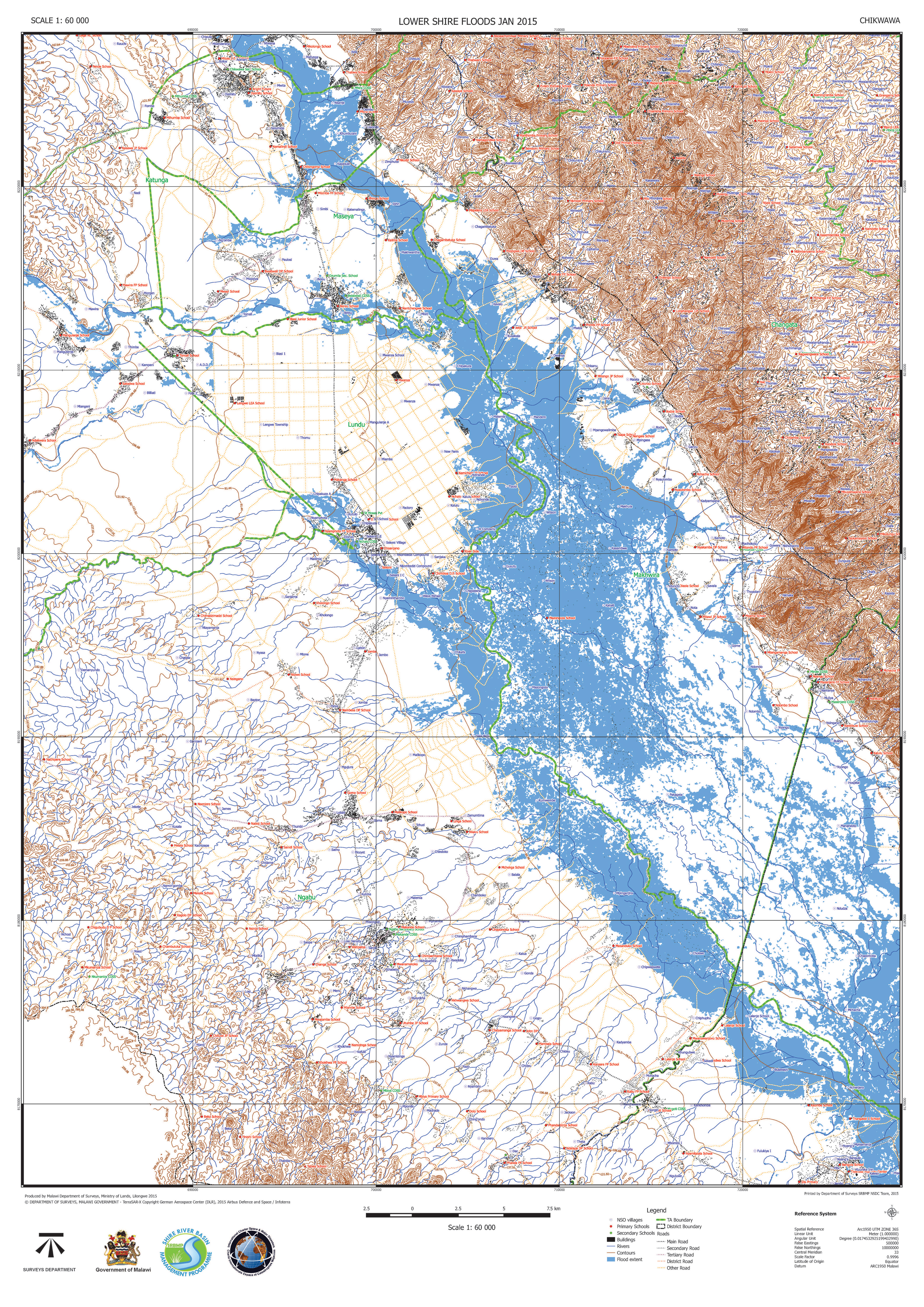
Bajar Shire Inundaciones en Chikwawa, Malawi
Copyright: RADARSAT-2 de datos y productos © MacDonald, Dettwiler y Asociados SA (2015) - Todos los derechos reservados. RADARSAT es una marca oficial de la Agencia Espacial Canadiense.
Mapa producido por Malawi Department of Surveys, Ministry of Lands
Information about the Product
Acquired: 13/01/2015
Source: RADARSAT-2

Detalle mapa - situación de las inundaciones en Bangula, Malawi
Copyright: RADARSAT-2 de datos y productos © MacDonald, Dettwiler y Asociados SA (2015) - Todos los derechos reservados. RADARSAT es una marca oficial de la Agencia Espacial Canadiense.
Landsat 8 de datos y productos © USGS (2015) - Todos los derechos reservados
Mapa producido por DLR/ZKI
Information about the Product
Acquired: RADARSAT-2: 13/01/2015
Landsat 8: 13/12/2014
Source: RADARSAT-2 / Landsat 8

Monitoreo mapa - situación de inundación en la región sur de Malawi
Copyright: RADARSAT-2 de datos y productos © MacDonald, Dettwiler y Asociados SA (2015) - Todos los derechos reservados. RADARSAT es una marca oficial de la Agencia Espacial Canadiense.
TerraSAR-X © German Aerospace Center (DLR), 2015 Airbus Defence and Space / Infoterra GmbH
Landsat 8 de datos y productos © USGS (2015) - Todos los derechos reservados
Mapa producido por DLR/ZKI
Information about the Product
Acquired: RADARSAT-2: 13/01/2015
TerraSAR-X: 10/01/2015
Landsat 8: 13/12/2014
Source: RADARSAT-2 / TerraSAR-X / Landsat 8

Mapa resumen - situación de las inundaciones en la región sur de Malawi
Copyright: TerraSAR-X © German Aerospace Center (DLR), 2015 Airbus Defence and Space / Infoterra GmbH
Landsat 8 de datos y productos © USGS (2015) - Todos los derechos reservados
Mapa producido por DLR/ZKI
Information about the Product
Acquired: TerraSAR-X: 10/01/2015
Landsat 8: 13/12/2014
Source: TerraSAR-X / Landsat 8
 Back to the full activation archive

