Charter activations
Flood in Indonesia
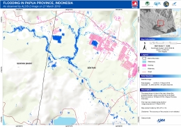
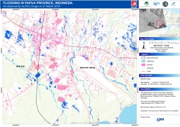
Indonesia's easternmost province of Papua experienced torrential rains which caused widespread flash flooding and triggered landslides affecting mountainside villages. 112 people are reported to have been killed with hundreds more injured.
4000 people have been displaced as flood waters forced people to flee their homes to seek higher ground. The worst landslides occurred in the city of Jayapura.
In Sentani a river burst its banks sweeping away people, their homes and other debris as the area received 18 inches of rainfall in three days.
Rescue teams have been evacuating residents and taking them to government shelters. The military and ambulance vehicles have been moving hundreds of casualties to hospitals and shelters.
Related News and Resources
| Type of Event: | Floods |
| Location of Event: | Indonesia |
| Date of Charter Activation: | 2019-03-19 |
| Time of Charter Activation: | 17:27 |
| Time zone of Charter Activation: | UTC+09:00 |
| Charter Requestor: | ADRC on behalf of LAPAN |
| Activation ID: | 600 |
| Project Management: | AIT |
Products

Flooding at Sentani, Indonesia
Copyright: RADARSAT-2 Data and Products © Maxar Technologies Ltd. (2019) - All Rights Reserved. RADARSAT is an official trademark of the Canadian Space Agency.
Map produced by Geoinformatics Center, AIT
Information about the Product
Acquired: Pre-disaster: 22/04/2017
Post-disaster: 19/03/2019
Source: RADARSAT-2
 Back to the full activation archive

 English
 Spanish
 French
 Chinese
 Russian
 Portuguese


