 English
 Spanish
 French
 Chinese
 Russian
 Portuguese
 最新宪章启动
Charter activations
马达加斯加气旋
3月15日,气旋Indiala以超过230公里/小时的速度在马达加斯加东北沿海地区登陆。到达内陆后,暴雨和125公里/小时的大风对当地造成了巨大破坏。到3月23日,救援机构和马达加斯加官方报道称大约有7.5-22.5万人遭受洪水和山体滑坡灾害,在戴安娜、萨瓦、索非亚和Analajirofo(马鲁安采特拉、Antalaga、Ananalava和安班扎等城镇)地区预计有1.5万人无家可归。水稻和香草作物损毁严重。
| 事件类型: | 气旋 |
| 事件地点: | 马达加斯加 |
| 启动宪章的日期: | 2007年3月23日 |
| 宪章要求者: | UNOOSA代表UNDP |
| 项目经理: | UNOSAT |
Products

Tropical cyclone Indiala, Vangaindrano 28/03/2007 Scale 1:200,000
版权: CSA 2000-2007, USGS 2001 in the framework of GMES RESPOND
Information about the Product
已获得: 28/03/2007 Flood extent derived from Radarsat-1 satellite imagery (23 March 2000 and 28 March 2007) over natural colour mosaic of Landsat 7 ETM+ images, acquired in April 2001 and September 2001.
源: RADARSAT-1, Landsat-7 ETM+, resolution 12.5m.

Tropical cyclone Indiala, Midongy 28/03/2007 Scale 1:75,000
版权: CSA 2000-2007, USGS 2001 in the framework of GMES RESPOND
Information about the Product
已获得: 28/03/2007 Flood space map 28 March 2007, Radarsat-1 satellite imagery; colour composition of archived (23 March 2000) and post-cyclone (28 March 2007) Radarsat-1 imagery.
源: RADARSAT-1, Landsat-7 ETM+, resolution 12.5m.
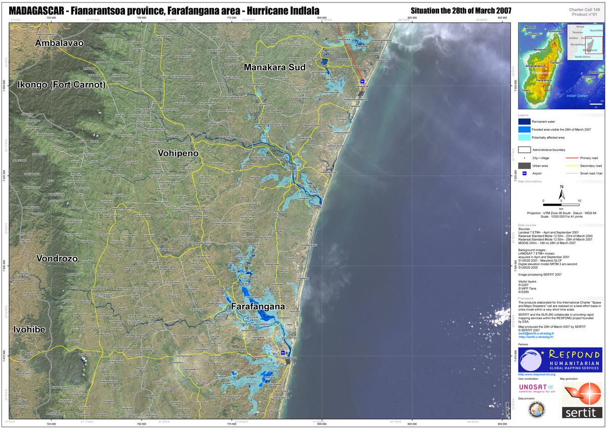
Tropical cyclone Indiala, Farafangana 28/03/2007 Scale 1:200,000
版权: CSA 2000-2007, USGS 2001 in the framework of GMES RESPOND
Information about the Product
已获得: 28/03/2007 Landsat-7 mosaic background image, Radarsat-1 standard mode 23-28 March 2007, showing flood extent
源: RADARSAT-1, Landsat-7 ETM+, resolution 12.5m.
 返回完整的响应档案

