 English
 Spanish
 French
 Chinese
 Russian
 Portuguese
 Latest Activation
Charter activations
Flooding in the Federated States Of Micronesia
Multiple states (in the Federated States of Micronesia) have experienced substantial coastal flooding from a combination of King tides, La Nina elevated sea levels, and strong northerly winds. There have been reports of substantial damage and a second event is expected with another bout of high tides.
The region consists of multiple atolls and islands, with multiple islets within each atoll. Many are very remote, taking a day or two to reach by boat. They are inhabited, and some settlements rely on subsistence agriculture harvested from neighboring islets.
Roads by Amata Kabua International Airport in Majuro was down to single lane traffic Monday afternoon as heavy equipment operators moved up and down the long roadway clearing rocks and debris that blocked the road from inrushing tidal water. Waves washing over boulder barriers caused flooding on the roads half a meter deep before receding.
The Hawaii-based, US government-funded Pacific Islands Ocean Observing System website forecasts tides to begin dropping in the coming days.
| Type of Event: | Flood |
| Location of Event: | Micronesia, Federated States Of |
| Date of Charter Activation: | 2021-12-08 |
| Time of Charter Activation: | 20:34 |
| Time zone of Charter Activation: | UTC-06:00 |
| Charter Requestor: | USGS |
| Activation ID: | 740 |
| Project Management: | USGS |
Products

Damange Assessment of Eastern Uman Island, Chuuk State
Copyright: © (2021) DigitalGlobe, Inc., Longmont CO USA 80503. DigitalGlobe and the DigitalGlobe logos are trademarks of DigitalGlobe, Inc. The use and/or dissemination of this data and/or of any product in any way derived there from are restricted. Unauthorized use and/or dissemination is prohibited
Map produced by USGS
Information about the Product
Acquired: 04/11/2021, 23/12/2021
Source: Worldview-2
Category: Grading Map

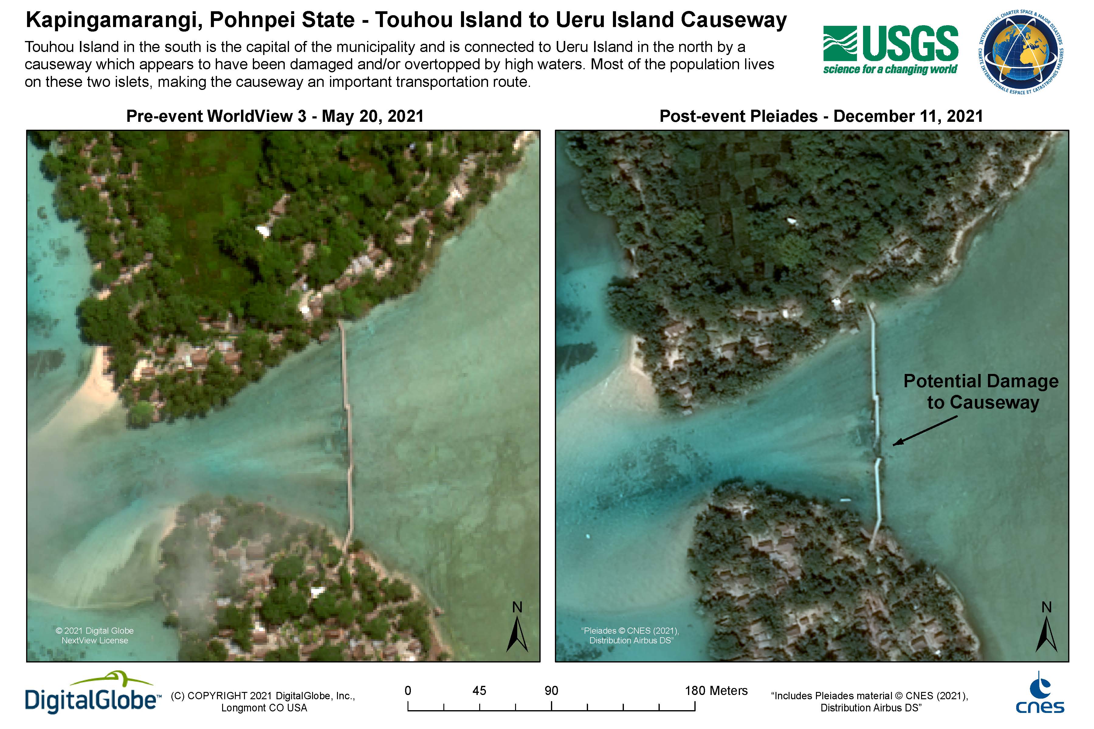
Kapingamarangi, Pohnpei State
Copyright: WorldView-3 © (2021) DigitalGlobe, Inc., Longmont CO USA 80503. DigitalGlobe and the DigitalGlobe logos are trademarks of DigitalGlobe, Inc. The use and/or dissemination of this data and/or of any product in any way derived there from are restricted. Unauthorized use and/or dissemination is prohibited
Includes Pleiades material © CNES (2021), Distribution Airbus DS.
Map produced by USGS
Information about the Product
Acquired: WorldView-3: 21/05/2021
Pleiades: 11/12/2021
Source: WorldView-3 / Pleiades
Category: Grading Map
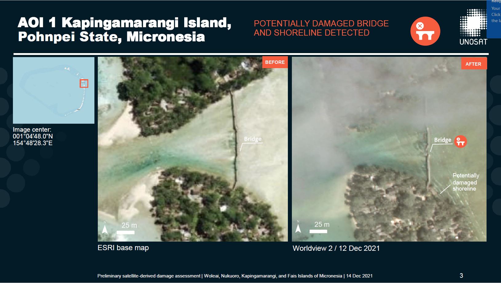
Preliminary damage assessment, Woleai, Nukuoro, Kapingamarangi, and Fais Islands of Micronesia
Download full report
Copyright: WorldView-2 © (2021) DigitalGlobe, Inc., Longmont CO USA 80503. DigitalGlobe and the DigitalGlobe logos are trademarks of DigitalGlobe, Inc. The use and/or dissemination of this data and/or of any product in any way derived there from are restricted. Unauthorized use and/or dissemination is prohibited
Includes Pleiades material © CNES (2021), Distribution Airbus DS.
Report produced by UNITAR / UNOSAT
Information about the Product
Acquired: Pleaides: 10/12/2021
WorldView-2: 12/12/2021
Source: WorldView-2 / Pleiades
Category: Grading Map
 Back to the full activation archive
