 English
 Spanish
 French
 Chinese
 Russian
 Portuguese
 Latest Activation
Charter activations
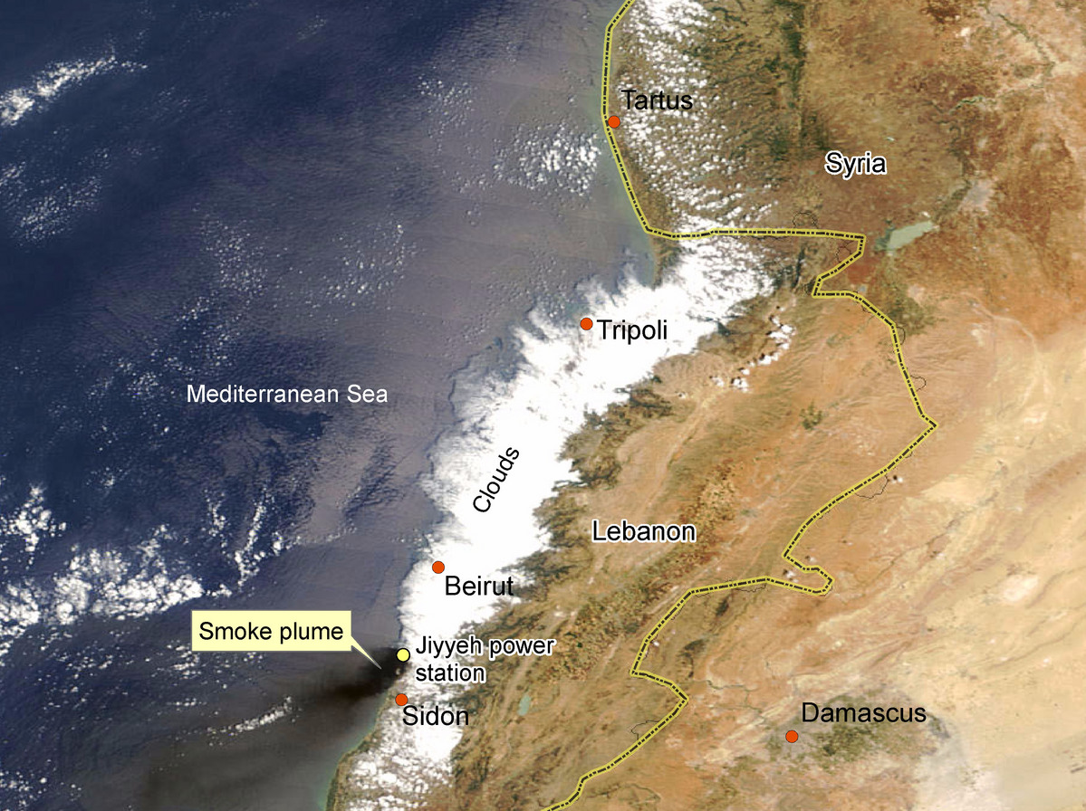
Oil spill off the coast of Lebanon
An estimated 30,000 tonnes of oil leaked into the Mediterranean from the Jiyeh power plant, 20 kilometers south of Beirut. The power plant was hit by Israeli air strikes on 13 and 15 July 2006. By 29 July the leaking oil had polluted a coastal zone some 130 kilometers long, north and south of the Lebanese capital.
| Tipo de evento: | Oil spill |
| Local do evento: | Lebanon |
| Data da Ativação da Carta: | 30/07/2006 |
| Requisitante da Carta: | European Commission Civil Protection Unit |
| Gerenciamento de projeto: | DLR |
Products
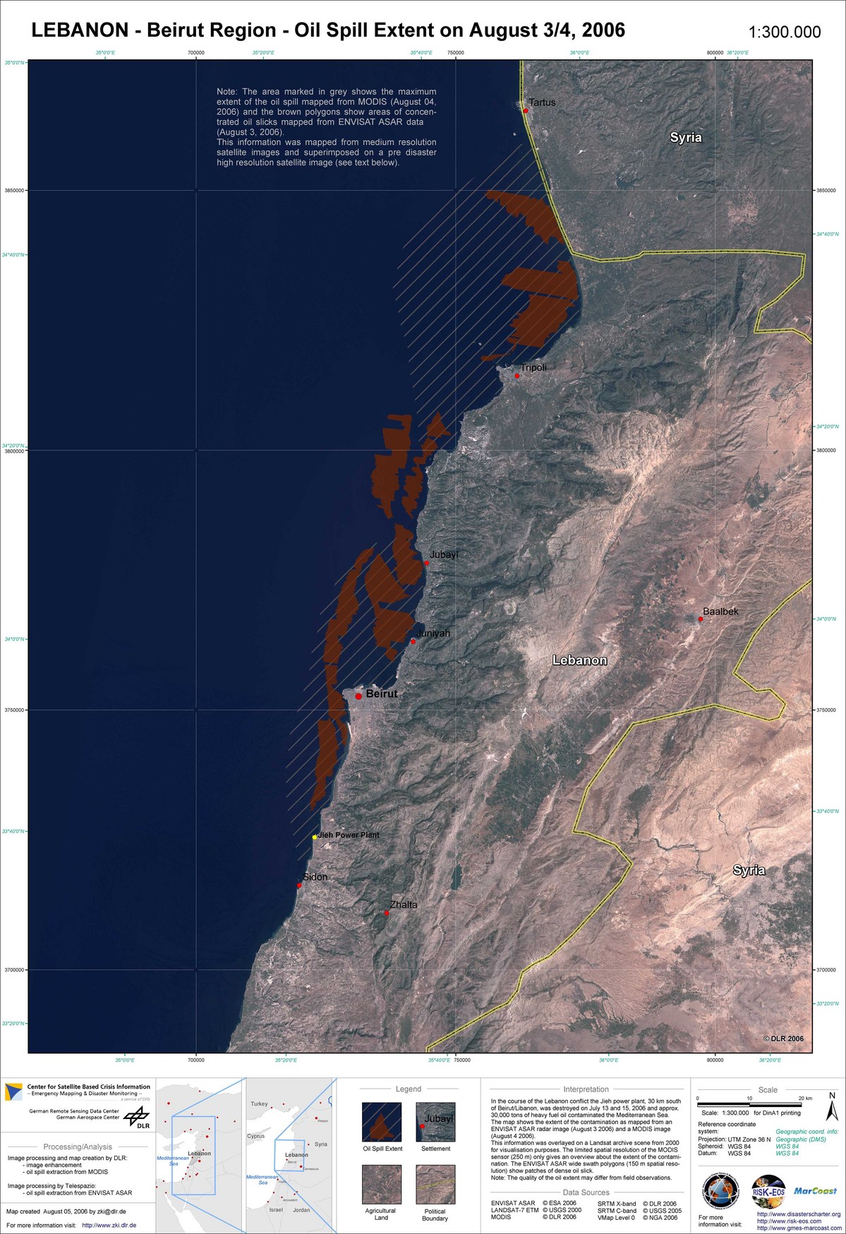
Lebanon Oilspill Overview
Direitos autorais: ESA 2006; NASA 2006; DLR 2006; USGS 2000 Image processing, map created 05/08/2006 by DLR. Image processing and information extraction by Telespazio in the framework of GSE MARCOAST. Analysis and map creation by DLR in the frame of GSE RISK-EOS.
150m (ASAR); 250m (MODIS); 30m (Landsat) resolution
Information about the Product
Adquirida: 03/08/2006, 04/08/2006; 21/07/2000
Fonte:
Envisat ASAR and Terra/Aqua MODIS; Landsat 7 ETM

Lebanon Oilspill Radar Imagery
Direitos autorais: ESA 2006; USGS 2000 Image processing, map created 05/08/2006 by DLR. Image processing and information extraction by Telespazio in the framework of GSE MARCOAST. Analysis and map creation by DLR in the frame of GSE RISK-EOS.
150m (ASAR); 30m (Landsat) resolution
Information about the Product
Adquirida: 21/07/2006, 03/08/2006; 21/07/2000
Fonte:
Envisat ASAR and Landsat 7 ETM

Lebanon Oilspill Annotated MODIS Time Series 04/08/2006
Direitos autorais:
NASA (MODIS Rapid Response System) Image processing, map created 05/08/2006 by DLR. Image processing and information extraction by Telespazio in the framework of GSE MARCOAST. Analysis and map creation by DLR in the frame of GSE RISK-EOS.
250m resolution
Information about the Product
Adquirida: 08/04/2006
Fonte:
Terra/Aqua MODIS

Lebanon Oilspill Annotated MODIS Time Series 01/08/2006
Direitos autorais:
NASA (MODIS Rapid Response System) Image processing, map created 05/08/2006 by DLR. Image processing and information extraction by Telespazio in the framework of GSE MARCOAST. Analysis and map creation by DLR in the frame of GSE RISK-EOS.
250m resolution
Information about the Product
Adquirida: 08/01/2006
Fonte:
Terra/Aqua MODIS

Lebanon Oilspill Annotated MODIS Time Series 23/07/2006
Direitos autorais:
NASA (MODIS Rapid Response System) Image processing, map created 05/08/2006 by DLR. Image processing and information extraction by Telespazio in the framework of GSE MARCOAST. Analysis and map creation by DLR in the frame of GSE RISK-EOS.
250m resolution
Information about the Product
Adquirida: 07/23/2006
Fonte:
Terra/Aqua MODIS

Lebanon Oilspill Annotated MODIS Time Series 19/07/2006
Direitos autorais:
NASA (MODIS Rapid Response System) Image processing, map created 05/08/2006 by DLR. Image processing and information extraction by Telespazio in the framework of GSE MARCOAST. Analysis and map creation by DLR in the frame of GSE RISK-EOS.
250m resolution
Information about the Product
Adquirida: 07/19/2006
Fonte:
Terra/Aqua MODIS
Lebanon Oilspill Annotated MODIS Time Series 16/07/2006
Direitos autorais:
NASA (MODIS Rapid Response System) Image processing, map created 05/08/2006 by DLR. Image processing and information extraction by Telespazio in the framework of GSE MARCOAST. Analysis and map creation by DLR in the frame of GSE RISK-EOS.
250m resolution
Information about the Product
Adquirida: 07/16/2006
Fonte:
Terra/Aqua MODIS

Lebanon Oilspill Overview
Direitos autorais:
ESA 2006; NASA 2006; DLR 2006 Image processing, map created 05/08/2006 by DLR. Image processing and information extraction by Telespazio in the framework of GSE MARCOAST. Analysis and map creation by DLR in the frame of GSE RISK-EOS.
250m (MODIS); 30m (Landsat) resolution
Information about the Product
Adquirida: 01/08/2006; 21/07/2000
Fonte:
Terra/Aqua MODIS; Landsat 7 ETM
 Voltar ao arquivo completo da Ativação

