 English
 Spanish
 French
 Chinese
 Russian
 Portuguese
OrderDesk-production-times-Master.xls
 OrderDesk-production-times-Master.xls
OrderDesk-production-times-Master.xls
授权用户
十年来,宪章成功地将卫星数据用于救灾,宪章正进一步扩大自己的影响力。宪章成员采用了授权用户原则,以进一步加强宪章对全世界灾害管理的贡献。任何国家的灾害管理部门都可以向宪章提交应急响应的请求(必须遵循适当的程序,但受影响的国家不一定是宪章成员)。
授权用户宪章成员以外的国家的国家灾害管理机构可以通过成为授权用户从宪章中获取帮助。
对于有兴趣作为授权用户参与宪章的国家,可以进行授权用户的申请。申请过程将验证申请人是否有能力按照宪章的操作程序,获取和使用宪章的资源来应对灾害。在宪章的授权用户手册中提供有申请表,也包含申请步骤和适用条件的说明。
地图:显示截至2022年2月可直接使用宪章的国家(深蓝色)
上面列出了以下国家:阿尔及利亚、阿根廷、亚美尼亚、澳大利亚、白俄罗斯、玻利维亚、巴西、喀麦隆、加拿大、开曼群岛、智利、中国、哥伦比亚、哥斯达黎加、多米尼加共和国、厄瓜多尔、萨尔瓦多、斯威士兰、埃塞俄比亚、冈比亚、加纳、危地马拉、洪都拉斯、印度、伊拉克、日本、韩国、马达加斯加、马拉维、墨西哥、蒙古、缅甸、新喀里多尼亚、尼加拉瓜、尼日利亚、挪威、巴基斯坦、巴拿马、巴拉圭、秘鲁、俄罗斯、所罗门群岛、南非、斯里兰卡、瑞士、坦桑尼亚、多哥、特立尼达和多巴哥、汤加、突尼斯、土耳其、阿联酋、乌干达、美国、乌拉圭、委内瑞拉和欧盟国家。
今天,宪章有来自83个国家的94个国家用户作为授权用户,他们可以直接提交紧急请求。此外,宪章与亚洲哨兵合作,这是一个在28个国家(91个国家组织)和15个国际组织的基于地球观测的应急反应区域网络,并与UNITAR/UNOSAT和UNOOSA合作,这两个组织活跃在许多国家,他们可以向宪章提交请求以支持联合国的国内救济机构。世界上所有国家都可以采取上述任何一种方式从宪章中受益。自2000年以来,宪章已经进行了870次响应,覆盖了全世界135个国家。
如何成为一个授权用户
如果你想作为授权用户参与宪章,授予你的组织在发生重大灾害时提交卫星图像请求的能力,请填写登记表。.
授权用户向任何国家的灾害管理部门开放注册,只要他们符合标准并遵循为授权用户规定的流程。
授权用户必须
- 是国家灾害管理机构或其在该国的委托机构
- 有能力下载和使用地图
- 能够用英语提交和进行其响应请求
该实体或其委托的机构应具有协调各自国家应急措施的国家授权。宪章提供的材料可以是遥感图像或衍生信息产品,如危机或损害评估地图。在启动请求中需要提供的基本信息包括:灾害发生的日期和时间、灾区的地理信息(纬度/经度)、灾害类型以及与宪章进行沟通的联系人姓名。
一旦你完成了登记表,流程如下。
- 请将登记表连同用户组织的信函提交给负责协调宪章事务的宪章执行秘书 (ExecutiveSecretariat@disasterscharter.org)。
- 该请求将由宪章成员处理,他们可能会要求提供更多信息。
- 国家用户的最终接受须经宪章委员会(宪章的政策机构)批准并通过正式信函发出书面通知。
- 新用户将被要求签署一份文件,具体说明宪章响应请求的流程和联系人。这是必要的,以确保遵守宪章的规则,并避免在紧急情况下的时间和资源损失。
地图:显示截至2022年2月可直接使用宪章的国家(深蓝色)
上面列出了以下国家:阿尔及利亚、阿根廷、亚美尼亚、澳大利亚、白俄罗斯、玻利维亚、巴西、喀麦隆、加拿大、开曼群岛、智利、中国、哥伦比亚、哥斯达黎加、多米尼加共和国、厄瓜多尔、萨尔瓦多、斯威士兰、埃塞俄比亚、冈比亚、加纳、危地马拉、洪都拉斯、印度、伊拉克、日本、韩国、马达加斯加、马拉维、墨西哥、蒙古、缅甸、新喀里多尼亚、尼加拉瓜、尼日利亚、挪威、巴基斯坦、巴拿马、巴拉圭、秘鲁、俄罗斯、所罗门群岛、南非、斯里兰卡、瑞士、坦桑尼亚、多哥、特立尼达和多巴哥、汤加、突尼斯、土耳其、阿联酋、乌干达、美国、乌拉圭、委内瑞拉和欧盟国家。
今天,宪章有来自83个国家的94个国家用户作为授权用户,他们可以直接提交紧急请求。此外,宪章与亚洲哨兵合作,这是一个在28个国家(91个国家组织)和15个国际组织的基于地球观测的应急反应区域网络,并与UNITAR/UNOSAT和UNOOSA合作,这两个组织活跃在许多国家,他们可以向宪章提交请求以支持联合国的国内救济机构。世界上所有国家都可以采取上述任何一种方式从宪章中受益。自2000年以来,宪章已经进行了870次响应,覆盖了全世界135个国家。
1000-2-metadata.csv
 1000-2-metadata.csv
1000-2-product.tif
1000-2-icon.jpg
1000-2-preview-high.jpg
 1000-2-preview-high.jpg
1000-2-preview-medium.jpg
 1000-2-preview-medium.jpg
1000-2-preview-low.jpg
 1000-2-preview-low.jpg
1000-2-preview.jpg
 1000-2-preview.jpg
OrderDesk-production-times-Master.xls
OrderDesk-production-times-Master.xls
OrderDesk-production-times-Master.xls
Mount Ruang volcano eruption in Indonesia
Charter activations
Mount Ruang volcano eruption in Indonesia
Mount Ruang, the southernmost stratovolcano in the Sangihe Islands arc, North Sulawesi, Indonesia had at least five large eruptions on 17 April, causing the Center for Volcanology and Geological Disaster Mitigation to issue its highest-level alert, indicating an active eruption.
Indonesian authorities issued a tsunami alert Wednesday after the eruptions, the worry is that part of the volcano could collapse into the sea and cause a tsunami amid fears of a repeat of the 1871 disaster.
There have been no reports of deaths or injuries so far but residents from nearby areas, including the remote island of Tagulandang, home to around 20,000 have been advised to evacuate and a local provinicial airport has been forced to close.
In 2018 the eruption of Indonesia's Anak Krakatau volcano caused a tsunami along the coasts of Sumatra and Java after parts of the mountain fell into the ocean, killing 430 people.
| 事件地点: | Indonesia |
| 启动宪章的日期: | 2024-04-19 |
| 宪章启动时间: | 10:16 |
| 宪章启动时区: | UTC+09:00 |
| 宪章要求者: | ADRC on behalf of National Research and Innovation Agency (BRIN) |
| 启动ID: | 873 |
| 项目经理: | Virgilius Rivan Seran (National Research and Innovation Agency (BRIN)) |
| act-value-adders: | Julie Griswold (USGS) National Research and Innovation Agency (BRIN) National Agency for Disaster Countermeasure (BNPB) Shiro KAWAKITA (JAXA) Michael Budde (USGS) |
Products


Dimensions of Gunung Ruang's crater prior to the eruption of 16-17 April 2024
版权: BlackSky Technology Inc. (on behalf of itself and its Affiliates, collectively "BlackSky") provides notification that its imagery and logos are trademarked and under copyrights of BlackSky. The further use and/or dissemination of this imagery and/or any product in any way derived there from are restricted without express prior written permission.
Map produced by Ministry of Energy and Mineral Resources of Indonesia
Information about the Product
已获得: 25/02/2024
源: GLOBAL
类别: Reference Map

Preliminary assessment of volcanic impact to Gunung Ruang, Indonesia: summit crater enlargement
版权: © DLR e.V. (2024), Distribution Airbus DS Geo GmbH
Map produced by Ministry of Energy and Mineral Resources of Indonesia
Information about the Product
已获得: 20/04/2024
源: TERRASAR_X
类别: Delineation Map

Preliminary assessment of volcanic impact to Gunung Ruang, Indonesia: southwest coast
版权: © 2024 DigitalGlobe, Inc., Longmont CO USA 80503. DigitalGlobe and the DigitalGlobe logos are trademarks of DigitalGlobe, Inc. The use and/or dissemination of this data and/or of any product in any way derived there from are restricted. Unauthorized use and/or dissemination is prohibited
Map produced by Ministry of Energy and Mineral Resources of Indonesia
Information about the Product
已获得: WORLDVIEW_1: 20/04/2024
WORLDVIEW_2: 15/09/2022
源: WORLDVIEW_1 / WORLDVIEW_2
类别: Delineation Map

Preliminary assessment of volcanic impact to Gunung Ruang, Indonesia: north coast
版权: © 2022 DigitalGlobe, Inc., Longmont CO USA 80503. DigitalGlobe and the DigitalGlobe logos are trademarks of DigitalGlobe, Inc. The use and/or dissemination of this data and/or of any product in any way derived there from are restricted. Unauthorized use and/or dissemination is prohibited
Map produced by Ministry of Energy and Mineral Resources of Indonesia
Information about the Product
已获得: WORLDVIEW_2: 15/09/2022
WORLDVIEW_1: 20/04/2024
源: WORLDVIEW_2 / WORLDVIEW_1
类别: Delineation Map
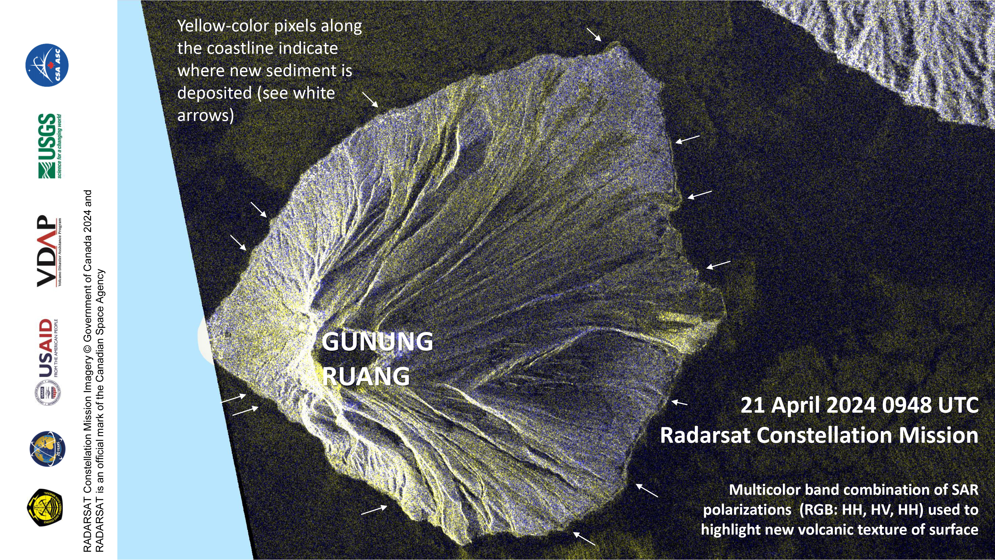
Preliminary map of pyroclastic flows on Gunung Ruang, Indonesia
版权: RADARSAT Constellation Mission Imagery © Government of Canada (2024) - RADARSAT is an official mark of the Canadian Space Agency
Map produced by Ministry of Energy and Mineral Resources of Indonesia
Information about the Product
已获得: 21/04/2024
源: RCM
类别: Delineation Map

Preliminary assessment of volcanic impact to Gunung Ruang, Indonesia
版权: © (2024) DigitalGlobe, Inc., Longmont CO USA 80503. DigitalGlobe and the DigitalGlobe logos are trademarks of DigitalGlobe, Inc. The use and/or dissemination of this data and/or of any product in any way derived there from are restricted. Unauthorized use and/or dissemination is prohibited
Map produced by Ministry of Energy and Mineral Resources of Indonesia
Information about the Product
已获得: 19/04/2024
源: WORLDVIEW-3
类别: Delineation Map

Preliminary assessment of Gunung Ruang across the island following the 16-17 April 2024 eruption
版权: RADARSAT Constellation Mission Imagery © Government of Canada (2024) - RADARSAT is an official mark of the Canadian Space Agency
Map produced by Ministry of Energy and Mineral Resources of Indonesia
Information about the Product
已获得: 21/04/2024
源: RCM
类别: Delineation Map

Preliminary assessment of volcanic impact to Gunung Ruang, Indonesia: Laingpatehi
版权: © 2024 DigitalGlobe, Inc., Longmont CO USA 80503. DigitalGlobe and the DigitalGlobe logos are trademarks of DigitalGlobe, Inc. The use and/or dissemination of this data and/or of any product in any way derived there from are restricted. Unauthorized use and/or dissemination is prohibited
Map produced by Ministry of Energy and Mineral Resources of Indonesia
Information about the Product
已获得: 19/04/2024
源: WORLDVIEW-3
类别: Delineation Map

Preliminary assessment of volcanic impact to Gunung Ruang, Indonesia: north Laingpatehi
版权: © 2024 DigitalGlobe, Inc., Longmont CO USA 80503. DigitalGlobe and the DigitalGlobe logos are trademarks of DigitalGlobe, Inc. The use and/or dissemination of this data and/or of any product in any way derived there from are restricted. Unauthorized use and/or dissemination is prohibited
Map produced Ministry of Energy and Mineral Resources of Indonesia
Information about the Product
已获得: 19/04/2024
源: WORLDVIEW-3
类别: Delineation Map

Preliminary assessment of volcanic impact to Gunung Ruang, Indonesia: south Laingpatehi
版权: © 2024 DigitalGlobe, Inc., Longmont CO USA 80503. DigitalGlobe and the DigitalGlobe logos are trademarks of DigitalGlobe, Inc. The use and/or dissemination of this data and/or of any product in any way derived there from are restricted. Unauthorized use and/or dissemination is prohibited
Map produced by Ministry of Energy and Mineral Resources of Indonesia
Information about the Product
已获得: 19/04/2024
源: WORLDVIEW-3
类别: Delineation Map

Preliminary assessment of volcanic impact to Gunung Ruang, Indonesia: near Pumpente on northwest shore
版权: © 2022 DigitalGlobe, Inc., Longmont CO USA 80503. DigitalGlobe and the DigitalGlobe logos are trademarks of DigitalGlobe, Inc. The use and/or dissemination of this data and/or of any product in any way derived there from are restricted. Unauthorized use and/or dissemination is prohibited
Map produced by Ministry of Energy and Mineral Resources of Indonesia
Information about the Product
已获得: WORLDVIEW-2: 15/09/2022
WORLDVIEW-1: 20/04/2024
源: WORLDVIEW-2 / WORLDVIEW-1
类别: Delineation Map

Preliminary assessment of volcanic impact to Gunung Ruang, Indonesia: northwest coast
版权: © 2022 DigitalGlobe, Inc., Longmont CO USA 80503. DigitalGlobe and the DigitalGlobe logos are trademarks of DigitalGlobe, Inc. The use and/or dissemination of this data and/or of any product in any way derived there from are restricted. Unauthorized use and/or dissemination is prohibited
Map produced by Ministry of Energy and Mineral Resources of Indonesia
Information about the Product
已获得: WORLDVIEW-2: 22/09/2022
WORLDVIEW-1: 20/04/2024
源: WORLDVIEW-2 / WORLDVIEW-1
类别: Delineation Map
 返回完整的响应档案
Areas affected by floods (Madagascar)

Contains modified Copernicus Sentinel data (2024)
Map produced by The Canadian Space Agency
OrderDesk-production-times-Master.xls
Mt. Ruang, North Sulawesi, Indonesia Before and After Eruption
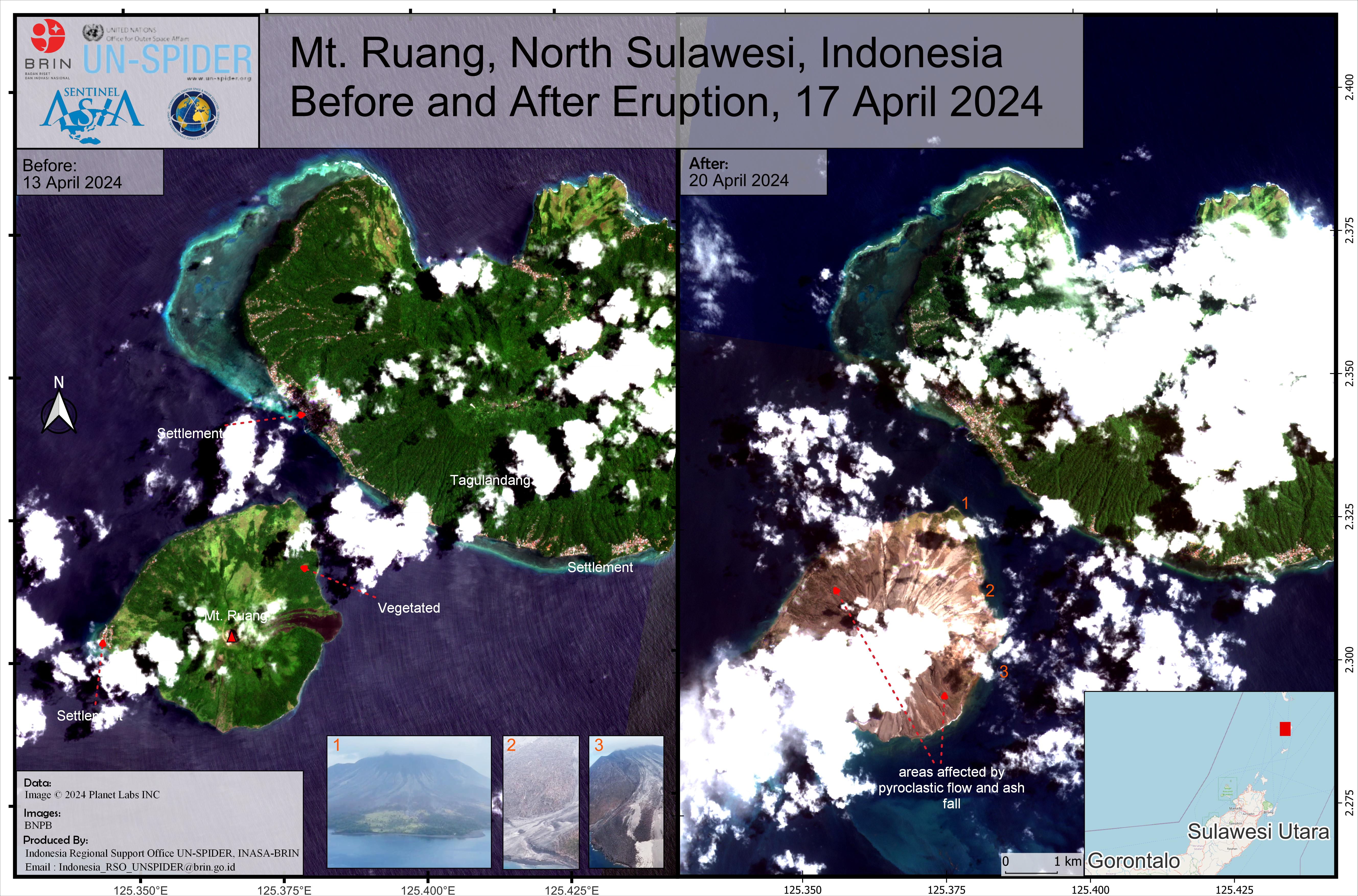
Map produced by UN-SPIDER
 urn_ogc_def_EOP_PHR_1B___CHARTER_ID1001_AOI1_SO24011873-2-01_DS_PHR1B_202404250216286_FR1_PX_E125N02_0509_01316-product.zip
